

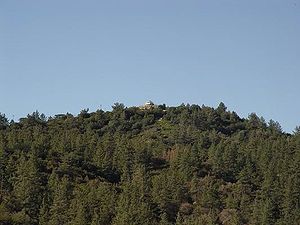
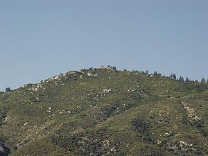
Vetter Mountain
Encyclopedia
Vetter Mountain is located in the San Gabriel Mountains
and within the Angeles National Forest
, Los Angeles County, California
. Elevation 5908 feet.
Named by USFS surveyor
Don McLain (ca. 1933) for Victor P. Vetter (nd.), a dedicated Forest Ranger and fire dispatcher. Vetter won the USFS Bissell Medal for outstanding work in forest conservation (1930).
The Silver Moccasin Trail
crosses the mountain on its eastern slopes.
, a ground mounted BC-3 type cab.
The lookout tower was built in 1937 and remained in service until 1981. Ramona Merwin, a USFS Fire Lookout
staffed the tower from 1953 until its closing. The tower was slated to be moved to the Chilao Visitors Center, but a group of active citizens in cooperation with the Forest Service were able to rebuild, restore, and return the tower to operational service in 1998. The tower was operated by the Angeles National Forest Fire Lookout Association
(ANFFLA) citizen volunteers in cooperation with the USDA Forest Service until it was destroyed by the 2009 Station Fire.
The lookout viewed several segments of the Angeles Crest Highway
, and had a clear view of Mount Wilson
to the south, and Mount Pacifico to the north.
grounds located to northeast face of Vetter Mountain, about 40 minutes drive from the Interstate 210
. The picnic area had about 185 tables and stoves and at one time there was piped water, however Charlton Flats has been closed for several years due to erosion
problems, overuse, and recent bark beetle
tree thining operations.
The original name of the area was Pine Flat when it was renamed to Charlton Flat in honor of the"new" forest service's first Forest Supervisor, Mr. R.H. Charlton. Mr. Charlton served as the Angeles National Forest Supervisor from 1905-1925 (20 years).
San Gabriel Mountains
The San Gabriel Mountains Range is located in northern Los Angeles County and western San Bernardino County, California, United States. The mountain range lies between the Los Angeles Basin and the Mojave Desert, with Interstate 5 to the west and Interstate 15 to the east...
and within the Angeles National Forest
Angeles National Forest
The Angeles National Forest of the U.S. National Forest Service is located in the San Gabriel Mountains of Los Angeles County, southern California. It was established on July 1, 1908, incorporating the first San Bernardino National Forest and parts of the former Santa Barbara and San Gabriel...
, Los Angeles County, California
California
California is a state located on the West Coast of the United States. It is by far the most populous U.S. state, and the third-largest by land area...
. Elevation 5908 feet.
Named by USFS surveyor
Surveying
See Also: Public Land Survey SystemSurveying or land surveying is the technique, profession, and science of accurately determining the terrestrial or three-dimensional position of points and the distances and angles between them...
Don McLain (ca. 1933) for Victor P. Vetter (nd.), a dedicated Forest Ranger and fire dispatcher. Vetter won the USFS Bissell Medal for outstanding work in forest conservation (1930).
The Silver Moccasin Trail
Silver Moccasin Trail
The Silver Moccasin Trail is a trail located in the San Gabriel Mountains, just northeast of Los Angeles. It begins at Chantry Flat Recreation Area above the city of Arcadia, California, traversing upward and down through several canyons and along the high ridges of the Angeles National Forest....
crosses the mountain on its eastern slopes.
Fire Lookout
Vetter Mountain was the site of historic Vetter Mountain Fire lookout towerFire lookout tower
A fire lookout tower, fire tower or lookout tower, provides housing and protection for a person known as a "fire lookout" whose duty it is to search for wildfires in the wilderness...
, a ground mounted BC-3 type cab.
The lookout tower was built in 1937 and remained in service until 1981. Ramona Merwin, a USFS Fire Lookout
Fire lookout
A fire lookout is a person assigned the duty to look for fire from atop a building known as a fire lookout tower. These towers are used in remote areas, normally on mountain tops with high elevation and a good view of the surrounding terrain, to spot smoke caused by a wildfire.Once a possible fire...
staffed the tower from 1953 until its closing. The tower was slated to be moved to the Chilao Visitors Center, but a group of active citizens in cooperation with the Forest Service were able to rebuild, restore, and return the tower to operational service in 1998. The tower was operated by the Angeles National Forest Fire Lookout Association
Angeles National Forest Fire Lookout Association
The Angeles National Forest Fire Lookout Association is a non-profit 501 organization of citizen volunteers dedicated to the preservation, restoration and operation of the fire lookout towers in the Angeles National Forest, Los Angeles County, and other Southern California areas...
(ANFFLA) citizen volunteers in cooperation with the USDA Forest Service until it was destroyed by the 2009 Station Fire.
The lookout viewed several segments of the Angeles Crest Highway
Angeles Crest Highway
The Angeles Crest Highway is a two-lane segment of California State Route 2 in the United States. The road is in length, with its western terminus at the intersection at Foothill Boulevard in La Cañada Flintridge and its eastern terminus at State Route 138 northeast of Wrightwood...
, and had a clear view of Mount Wilson
Mount Wilson (California)
Mount Wilson is one of the better known peaks in the San Gabriel Mountains, part of the Angeles National Forest in Los Angeles County, California. It is the location of the Mount Wilson Observatory and has become the astronomical center of Southern California with and telescopes, and and tall...
to the south, and Mount Pacifico to the north.
Charlton Flats
Charlton Flats is a picnicPicnic
In contemporary usage, a picnic can be defined simply as a pleasure excursion at which a meal is eaten outdoors , ideally taking place in a beautiful landscape such as a park, beside a lake or with an interesting view and possibly at a public event such as before an open air theatre performance,...
grounds located to northeast face of Vetter Mountain, about 40 minutes drive from the Interstate 210
Interstate 210 (California)
Interstate 210 and State Route 210 together form a contiguous highway, called the Foothill Freeway, in the Greater Los Angeles area of the U.S. state of California. The western portion of the route is an auxiliary Interstate Highway, while the eastern portion is a state highway...
. The picnic area had about 185 tables and stoves and at one time there was piped water, however Charlton Flats has been closed for several years due to erosion
Erosion
Erosion is when materials are removed from the surface and changed into something else. It only works by hydraulic actions and transport of solids in the natural environment, and leads to the deposition of these materials elsewhere...
problems, overuse, and recent bark beetle
Bark beetle
A bark beetle is one of approximately 220 genera with 6,000 species of beetles in the subfamily Scolytinae. Traditionally, this was considered a distinct family Scolytidae, but now it is understood that bark beetles are in fact very specialized members of the "true weevil" family...
tree thining operations.
The original name of the area was Pine Flat when it was renamed to Charlton Flat in honor of the"new" forest service's first Forest Supervisor, Mr. R.H. Charlton. Mr. Charlton served as the Angeles National Forest Supervisor from 1905-1925 (20 years).
| Northern Slope Vetter Mountain is between the "Chaparral Chaparral Chaparral is a shrubland or heathland plant community found primarily in the U.S. state of California and in the northern portion of the Baja California peninsula, Mexico... " zone to the South, and the "Montane Forest" to the North. The "Chaparral" zone is found on the hot, dry, south facing slopes of the foothills of the San Gabriel Mountains. Plants are chest height, dense, prickly, and evergreen Evergreen In botany, an evergreen plant is a plant that has leaves in all seasons. This contrasts with deciduous plants, which completely lose their foliage during the winter or dry season.There are many different kinds of evergreen plants, both trees and shrubs... ; typically contains Chamise, Yucca Yucca Yucca is a genus of perennial shrubs and trees in the family Asparagaceae, subfamily Agavoideae. Its 40-50 species are notable for their rosettes of evergreen, tough, sword-shaped leaves and large terminal panicles of white or whitish flowers. They are native to the hot and dry parts of North... , Ceanothus Ceanothus Ceanothus L. is a genus of about 50–60 species of shrubs or small trees in the buckthorn family Rhamnaceae. The genus is confined to North America, the center of its distribution in California, with some species in the eastern United States and southeast Canada, and others extending as far south... , Scrub Oak Scrub Oak Scrub Oak is a general name for several species of small, shrubby oaks, including the following species:*California Scrub Oak *Leather Oak *Coastal Scrub Oak... , Laurel Sumac Malosma Malosma is a plant genus which contains only a single species, Malosma laurina, with the common names Laurel sumac and Lentisco .... , White Sage White sage Salvia apiana is an evergreen perennial shrub that is native to the southwestern United States and northwestern Mexico, found mainly in the coastal sage scrub habitat of Southern California and Baja California, on the western edges of the Mojave and Sonoran deserts.-Description :S... Black Sage Black Sage Salvia mellifera is a small, highly aromatic, evergreen shrub of the genus Salvia native to California, and Baja California, Mexico. It is common in the coastal sage scrub of Southern California and northern Baja California... , Poison Oak Poison oak Poison oak may refer to* Toxicodendron diversilobum, grows on West Coast of North America* Toxicodendron pubescens, grows in the Eastern United Statesdamnnnnn tissss is terribleee... , and in the higher elevations, Manzanita Manzanita Manzanita is a common name for many species of the genus Arctostaphylos. They are evergreen shrubs or small trees present in the chaparral biome of western North America, where they occur from southern British Columbia, Washington to California, Arizona and New Mexico in the United States, and... and Mountain Mahogany. |
 |
| Southern Slope Vetter Mountain is between the "Chaparral Chaparral Chaparral is a shrubland or heathland plant community found primarily in the U.S. state of California and in the northern portion of the Baja California peninsula, Mexico... " zone to the south, and the "Montane Forest" to the north. The Montaine zone contains Bigcone Spruce, Canyon oak, Jeffrey Pine Jeffrey Pine The Jeffrey Pine, Pinus jeffreyi, named in honor of its botanist documenter John Jeffrey, is a North American pine related to Ponderosa Pine.-Distribution and habitat:... , Sugar Pine Sugar Pine Pinus lambertiana, commonly known as the sugar pine or sugar cone pine, is the tallest and most massive pine, with the longest cones of any conifer... , Incense Cedar and White Fir White Fir White Fir is a fir native to the mountains of western North America, occurring at altitudes of 900-3,400 m. It is a medium to large evergreen coniferous tree growing to 25–60 m tall and with a trunk diameter of up to 2 m . It is popular as an ornamental landscaping tree and as a Christmas Tree... . |
 |