

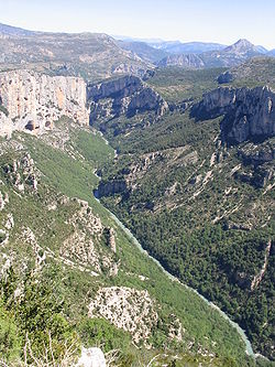
Verdon Gorge
Encyclopedia
Alpes-de-Haute-Provence
Alpes-de-Haute-Provence is a French department in the south of France, it was formerly part of the province of Provence.- History :Nord-de-Provence was one of the 83 original departments created during the French Revolution on 4 March 1790...
), is a river canyon
Canyon
A canyon or gorge is a deep ravine between cliffs often carved from the landscape by a river. Rivers have a natural tendency to reach a baseline elevation, which is the same elevation as the body of water it will eventually drain into. This forms a canyon. Most canyons were formed by a process of...
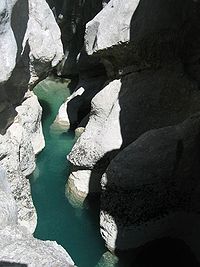
that is often considered to be one of Europe's most beautiful. It is about 25 kilometres long and up to 700 metres deep. It was formed by the Verdon River
Verdon River
The Verdon is a 166 km long river in south-eastern France, left tributary of the Durance. Its source is at an altitude of 2819 m, in the south-western Alps , between the col d'Allos and the Trois Eveches mountain, south of Barcelonnette...
, which is named after its startling turquoise
Turquoise
Turquoise is an opaque, blue-to-green mineral that is a hydrous phosphate of copper and aluminium, with the chemical formula CuAl648·4. It is rare and valuable in finer grades and has been prized as a gem and ornamental stone for thousands of years owing to its unique hue...
-green colour, one of the canyon's most distinguishing characteristics. The most impressive part lies between the towns of Castellane
Castellane
Castellane is a commune in the Alpes-de-Haute-Provence department in southeastern France.-Population:-References:*...
and Moustiers-Sainte-Marie
Moustiers-Sainte-Marie
Moustiers-Sainte-Marie, or simply Moustiers, is a commune in the Alpes-de-Haute-Provence department in southeastern France, a part of the Provence-Alpes-Côte d'Azur region....
, where the river has cut a ravine
Ravine
A ravine is a landform narrower than a canyon and is often the product of streamcutting erosion. Ravines are typically classified as larger in scale than gullies, although smaller than valleys. A ravine is generally a fluvial slope landform of relatively steep sides, on the order of twenty to...
up to 700 metres down through the limestone
Limestone
Limestone is a sedimentary rock composed largely of the minerals calcite and aragonite, which are different crystal forms of calcium carbonate . Many limestones are composed from skeletal fragments of marine organisms such as coral or foraminifera....
mass. At the end of the canyon, the Verdon river flows into the artificial lake of Sainte-Croix-du-Verdon
Sainte-Croix-du-Verdon
Sainte-Croix-du-Verdon is a commune in the Alpes-de-Haute-Provence department in southeastern France.Prior to 16 September 2005, the commune was known as Sainte-Croix-de-Verdon.-Population:-References:*...
(in French: Lac de Sainte-Croix
Lac de Sainte-Croix
The Lake of Sainte-Croix is a man-made lake that was formed by the construction, between 1971 and 1974 of a reinforced concrete arch dam by the name of Dam of Sainte-Croix . The reservoir holds a maximum of 761 million cubic metres of water...
).
Because of its proximity to the French Riviera
French Riviera
The Côte d'Azur, pronounced , often known in English as the French Riviera , is the Mediterranean coastline of the southeast corner of France, also including the sovereign state of Monaco...
, the canyon is very popular with tourists, who can drive around its rim, rent kayak
Kayak
A kayak is a small, relatively narrow, human-powered boat primarily designed to be manually propelled by means of a double blade paddle.The traditional kayak has a covered deck and one or more cockpits, each seating one paddler...
s or hike
Hiking
Hiking is an outdoor activity which consists of walking in natural environments, often in mountainous or other scenic terrain. People often hike on hiking trails. It is such a popular activity that there are numerous hiking organizations worldwide. The health benefits of different types of hiking...
. The limestone walls, which are several hundreds of metres high, attract many rock climbers
Rock climbing
Rock climbing also lightly called 'The Gravity Game', is a sport in which participants climb up, down or across natural rock formations or artificial rock walls. The goal is to reach the summit of a formation or the endpoint of a pre-defined route without falling...
. It is considered an outstanding destination for multi-pitch climbing
Multi-pitch climbing
Multi-pitch climbing is the ascent of climbing routes with one or more stops at a belay station. Each section of actual climbing between stops at the belay stations is called a pitch. The leader ascends the pitch, placing gear and stopping to anchor themselves to the belay station.The reason for...
. There are routes encompassing cracks, pillars and seemingly endless walls. The climbing is generally of a technical nature, and there are over 1,500 routes, ranging from 20m to over 400m.
History
During the Triassic period, the French region of ProvenceProvence
Provence ; Provençal: Provença in classical norm or Prouvènço in Mistralian norm) is a region of south eastern France on the Mediterranean adjacent to Italy. It is part of the administrative région of Provence-Alpes-Côte d'Azur...
subsided and was covered by the sea, leaving thick layers of various limestone
Limestone
Limestone is a sedimentary rock composed largely of the minerals calcite and aragonite, which are different crystal forms of calcium carbonate . Many limestones are composed from skeletal fragments of marine organisms such as coral or foraminifera....
deposits. Several million years later, with the arrival of the Jurassic period, the area was covered by a warm shallow sea, which allowed the growth of various Corals. The Cretaceous period saw what is now Basse Provence being raised and the sea reaching the current location of the Alps, which were themselves erected during the tertiary era. As a result of the large scale geological activity resulting from this, many of the Jurassic
Jurassic
The Jurassic is a geologic period and system that extends from about Mya to Mya, that is, from the end of the Triassic to the beginning of the Cretaceous. The Jurassic constitutes the middle period of the Mesozoic era, also known as the age of reptiles. The start of the period is marked by...
limestone deposits fractured, forming relief with valleys and other such features. Indeed, it is to this epoch that the origins of the Verdon Gorge can be traced. The dawn of the Quaternary period witnessed large scale glaciation, transforming water pockets and lakes into unstoppable rivers of ice, which remodeled the topography, scouring and striating the landscape. At the end of this activity, erosion by rivers continued, forming the Gorge as it is today. The Verdon’s river bed was scoured for a second time of the accumulated coral and limestone sediments, by a water delivery rate nearing 2000 to 3000 cubic metres per second.
Discovery
There are printed descriptions of the gorge from 1782 and 1804, and in tourist guides of the second half of the 19th century. According to Graham RobbGraham Robb
Graham Macdonald Robb FRSL is a British author.Robb was born in Manchester and educated at the Royal Grammar School Worcester and Exeter College, Oxford, where he studied Modern Languages...
's book "The Discovery of France
The Discovery of France
The Discovery of France: A Historical Geography, from the Revolution to the First World War is a book by Graham Robb. It was published in the United Kingdom by Picador in September 2007 and in the United States by W. W. Norton and Company in October 2007...
" the gorge was unknown to the outside world until 1906.
Recent developments
On 10 July 2006, the French Conseil d'État annulled the declaration of public use of the EDF (Électricité de FranceÉlectricité de France
Électricité de France S.A. is the second largest French utility company. Headquartered in Paris, France, with €65.2 billion in revenues in 2010, EDF operates a diverse portfolio of 120,000+ megawatts of generation capacity in Europe, Latin America, Asia, the Middle East and Africa.EDF is one of...
; Electricity of France)’s project, relating to a high voltage line carrying 400,000 volts which would have had to pass through the Verdon Gorge. This decision ended 23 years of struggle by public groups and associations of environmental defence to preserve a site of exceptional natural interest, of which a part contains protected animal and plant species.
Geography

Col d'Allos
Col d'Allos is a high mountain pass in the Alps in the department of Alpes-de-Haute-Provence in France.It connects Barcelonnette in the Ubaye Valley and Colmars and goes on to the Col des Champs....
hill in the Trois Eveches mountain range, from where it continues, flowing into the Durance
Durance
The Durance is a major river in south-eastern France.Its source is in the south-western Alps, in Montgenèvre ski resort near Briançon and it flows south-west through the following départements and cities:* Hautes-Alpes: Briançon, Embrun.* Alpes-de-Haute-Provence: Sisteron, Manosque.* Vaucluse:...
river near Vinon-sur-Verdon
Vinon-sur-Verdon
Vinon-sur-Verdon is an commune in the Var department in the Provence-Alpes-Côte d'Azur region in southeastern France.It is on the left bank of the River Verdon near the Gorge de Verdon....
after traveling 175 kilometres. The most interesting part of this journey is found between Castellane
Castellane
Castellane is a commune in the Alpes-de-Haute-Provence department in southeastern France.-Population:-References:*...
and the Pont du Galetas, on the lac de Sainte-Croix
Lac de Sainte-Croix
The Lake of Sainte-Croix is a man-made lake that was formed by the construction, between 1971 and 1974 of a reinforced concrete arch dam by the name of Dam of Sainte-Croix . The reservoir holds a maximum of 761 million cubic metres of water...
. Some decades ago, this Lake used to be the large plain of Les Salles-sur-Verdon
Les Salles-sur-Verdon
Les Salles-sur-Verdon is a commune in the Var department in the Provence-Alpes-Côte d'Azur region in southeastern France.-References:*...
, before the construction of a reservoir created by the erecting of the Sainte-Croix
Sainte-Croix
Sainte-Croix is the name or part of the name of several places:-In France:*Sainte-Croix, Ain, in the Ain département*Sainte-Croix, Aisne, in the Aisne département*Sainte-Croix, Aveyron, in the Aveyron département...
dam. At the time of the raising of the water level in 1973, the old village des Salles was evacuated by force, destroyed and inundated. The church was dynamited, as was the rest of the village, which has been reconstructed higher up the valley as a more modern settlement, to the great displeasure of its inhabitants. Today, it is the youngest village in France.
For some distance the Verdon Gorge forms the border between the départements of Var
Var (département)
The Var is a French department in the region Provence-Alpes-Côte d'Azur in Provence, in southeast France. It takes its name from the river Var, which used to flow along its eastern boundary, but the boundary was moved in 1860...
to the south and Alpes-de-Haute-Provence
Alpes-de-Haute-Provence
Alpes-de-Haute-Provence is a French department in the south of France, it was formerly part of the province of Provence.- History :Nord-de-Provence was one of the 83 original departments created during the French Revolution on 4 March 1790...
to the north in the Provence-Alpes-Côte d'Azur
Provence-Alpes-Côte d'Azur
Provence-Alpes-Côte d'Azur or PACA is one of the 27 regions of France.It is made up of:* the former French province of Provence* the former papal territory of Avignon, known as Comtat Venaissin...
région.
This region, between Castellan and the Lac de Sainte-Croix is called the ‘’’Gorges du Verdon’’’; ‘’’Verdon Gorge’’’. It is split into three distinct parts:
the “Prégorges” (‘pre-gorge’) which goes from Castellane to Pont de Soleils,
the Gorge itself which goes from Pont de Soleils to l'Imbut, and
the Canyon which goes from l’Imbut to the Pont de Galetas.
The Verdon Gorge is narrow and deep, with depths of 250 to 700 metres and widths of 6 to 100 metres at the level of the Verdon river, and 200 to 1500 metres from one side of the Gorge to the other at the summit.
Hydro-electric dams
Overview
Between 1929 and 1975, five dams were erected on the course of the Verdon, between Castellane and Gréoux-les-BainsGréoux-les-Bains
Gréoux-les-Bains is a commune in the Alpes-de-Haute-Provence department in southeastern France.-Population:-References:*...
. These Dams hold back water in the following reservoirs:
- Lac de Castillon, with the engulfing of the village of the same name
- Lac de Sainte-Croix, with the engulfing of village des Salles-sur-Verdon, of the Roman bridge of pont de Garuby or pont d’AiguinesAiguinesAiguines is a commune in the Var department in the Provence-Alpes-Côte d'Azur region in southeastern France.-External links:...
and of the “Bishop’s” spring at BauduenBauduenBauduen is a commune in the Var department in the Provence-Alpes-Côte d'Azur region in southeastern France....
. With marvellous and changing colours nearly every day, it has become a high spot for summer tourism. It is the largest reservoir in France; - Lac d'Esparron-Gréoux, known locally as “lac d’Esparron”. It is coloured green, like the Verdon, but unlike lac de Sainte-Croix, in which the colour blue dominates.
- The reservoir at Chaudanne
- The reservoir at Quinson, sometimes improperly called the "lac de MontpezatMontagnac-MontpezatMontagnac-Montpezat is a commune in the Alpes-de-Haute-Provence department in southeastern France.-References:*...
", the name of the village over which it dominates.
Notable features
Styx (mythology)
The Styx is a river in Greek mythology that formed the boundary between Earth and the Underworld . It circles the Underworld nine times...
of Greek mythology
Greek mythology
Greek mythology is the body of myths and legends belonging to the ancient Greeks, concerning their gods and heroes, the nature of the world, and the origins and significance of their own cult and ritual practices. They were a part of religion in ancient Greece...
is like a sub-canyon within the canyon itself.
The "Imbut", also known as "Embut" or "Embucq" is a sort of funnel where the Verdon disappears underground, beneath enormous rock structures.
Tourism
The Verdon Gorge is renowned as one of the most beautiful canyons in Europe, and attracts numerous tourists, especially during the summer period. It is easily accessible on its right bank from the North (via route D952 from Castellane to Moustiers-Sainte-Marie), and on its left bank from the South (via routes D71, D90 and D995 from AiguinesAiguines
Aiguines is a commune in the Var department in the Provence-Alpes-Côte d'Azur region in southeastern France.-External links:...
to Castellane
Castellane
Castellane is a commune in the Alpes-de-Haute-Provence department in southeastern France.-Population:-References:*...
).
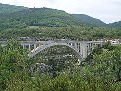
The southern route offers views of the Col d'Illoire, the summits of Plein Voir, le Pavillon (1624 m), la cime de Barbin (1560 m) and le Mourre de Chanier (1930 m), and the Saint-Croix reservoir. The "Sentier de l'Imbut" hike begins from this side of the gorge. When the road passes through the Tunnel du Fayet, there are openings cut into the tunnel to afford a view. The road then crosses the Artuby River over a bridge known either as Pont de l'Artuby or Pont de Chaulière; soon after, at the relais de Balcon, the Artuby flows into the Verdon. This area is also known as the "Mescla," meaning "mixture" in Provençal.
Trigance
Trigance is a commune in the Var department in the Provence-Alpes-Côte d'Azur region in southeastern France.-References:*...
, another bridge spans the Jabron river (another tributary of the Verdon) and then the Pont des Soleils. Just below Rougon there is the Couloir Samson (Samson's Corridor), the entrance to the part of the fluvial landscape designated as "gorge." From there one can hike along the Verdon and take the famous "Sentier Martel." La Palud-sur-Verdon
La Palud-sur-Verdon
La Palud-sur-Verdon is a commune in the Alpes-de-Haute-Provence department in southeastern France.-Population:-References:*...
, a village with museum and tourist bureau, is nearby; the "route des Crêtes" (Crest Route, linking various panoramic viewpoints) proceeds from here. The Sentier Martel also is accessible from this route, beginning at the French Alpine Club or "châlet de La Maline." This path covers over 100 km of not always easy roads.
Sport
The Verdon Gorge is an appreciated destination for rock climbers, since it includes more than 1,500 climbing routes on good limestone rock.The Verdon and its Gorge is also a favoured destination for fishermen, particularly for fly fishing
Fly fishing
Fly fishing is an angling method in which an artificial 'fly' is used to catch fish. The fly is cast using a fly rod, reel, and specialized weighted line. Casting a nearly weightless fly or 'lure' requires casting techniques significantly different from other forms of casting...
.
Hiking, Canoeing
Canoeing
Canoeing is an outdoor activity that involves a special kind of canoe.Open canoes may be 'poled' , sailed, 'lined and tracked' or even 'gunnel-bobbed'....
, paragliding
Paragliding
Paragliding is the recreational and competitive adventure sport of flying paragliders: lightweight, free-flying, foot-launched glider aircraft with no rigid primary structure...
, rafting
Rafting
Rafting or white water rafting is a challenging recreational outdoor activity using an inflatable raft to navigate a river or other bodies of water. This is usually done on white water or different degrees of rough water, in order to thrill and excite the raft passengers. The development of this...
, climbing
Climbing
Climbing is the activity of using one's hands and feet to ascend a steep object. It is done both for recreation and professionally, as part of activities such as maintenance of a structure, or military operations.Climbing activities include:* Bouldering: Ascending boulders or small...
and of course Canyoning
Canyoning
Canyoning is traveling in canyons using a variety of techniques that may include other outdoor activities such as walking, scrambling, climbing, jumping, abseiling, and/or swimming....
are some of the numerous sports practiced in the region.
Hiking and scenic walks
The most famous and beautiful hikes in the gorge include:- Le sentier (pathway) de Martel
- Le sentier de l'Imbut
- Le sentier du Bastidon
- Le belvédère de Rancoumas par le pont de Tusset (the Rancoumas panoramic viewpoint near the Tusset Bridge)
The most famous of these, the Sentier Martel, was laid out in 1928 by the Touring Club de France, and given its present name in 1930 to honor the explorer Édouard-Alfred Martel
Édouard-Alfred Martel
, the 'father of modern speleology', was a world pioneer of cave exploration, study, and documentation...
(1859–1938). Martel had visited the Verdon in 1905 as an employee of the Southeast Electricity Company, carrying out precise geological surveys of the river. On 11 August, he and his team (explorer Armand Janet, schoolmaster Isidore Blanc, geographer Cuvelier, plaus Baptistin Flory, Fernand Honorat, Prosper Marcel, and Tessier Zurcher) began an expedition of the region by boat and foot (especially when one of the boats became unusable). They discovered a narrow corridor which Martel named "Styx." When they arrived at Imbut (meaning "narrow" or "funnel" in Provençal) Martel wished to abandon the expedition, but his comrades encouraged him to continue. They entered the canyon proper and discovered more passages and rock formations; their successful arrival at the Pas de Galetas marked the completion of the first expedition of the Verdon Canyon.
Other expeditions to the Verdon included Martel's team the following year; Robert de Joly
Robert de Joly
Robert-Jacques de Joly was a famous French caver and speleologist. Considered by some as the successor to Édouard-Alfred Martel , de Joly was a leading figure of French speleology between the world wars and into the 1960s.De Joly was an active cave explorer throughout his entire life, from age...
who in 1928 was the first to completely cross the Verdon Gorge, passing over the Imbut; explorer and filmmaker Albert Mahuzier in 1938 and 1939; a group of Scouts
Scouting in France
The Scout movement in France consists of about 80 different associations and federations with about 180,000 Scouts and Girl Guides. Next to Germany, France is the country with the most fragmented Scout movement....
in 1945 and the Canoe Club of France in 1946; and Roger Verdegen, who made several expeditions in a boat made from animal hides and natural rubber, and became an authority on the Verdon.
The hiking route
From the chalet de la Maline to the Point Sublime, passing through Martel’s pathway with a detour via the Mescla.The present-day Sentier Martel travels 15 kilometres (9.3 mi) along the right bank of the river Verdon from its entrance into the Canyon (Point Sublime) to the Châlet de la Maline. Some experienced hikers can do the round trip by foot in 12 to 13 hours; for those going one way, this section of the hike takes 7 to 8 hours with the detour via La Mescla.
Beginning at La Maline and going toward the canyon, the route descends in hairpins to join the water at the Estellié ford. Notable sights along this section include the Ravin de Charençon, the Pas d'Issabe, the Pré d'Issane (a small pebble beach along the Verdon), the Étroit des Cavaliers (a narrow passage between cliffs), the Guèges scree, and the large cave of Baume-aux-Boefus.
A detour allows one to visit la Mescla, where the Artuby river joins the Verdon, and where the Abbot Pascal, one of the Verdon's pioneers, drowned in 1928.
The main path towards the Point Sublime quickly ascends and comes to the Brèche Embert and its 6 stairways, totaling 252 steps (descending). Thereafter, the route climbs again along the Verdon, first very high above the riverbanks, then very close, to arrive at a pebble beach by the Baumes-Fères stream, near the cliff of l'Escalès.
The hike continues along the river bed, passing the Tours de Trescaïre on the other bank: two impressive monolithic pyramids. Then comes three tunnels: the Tunnel des Baumes, the Tunnel de Trescaïre, and the Tunnel du Baou, which were originally built for hydroelectric projects that were abandoned after World War II. Hikers wishing to explore these need pocket lamps and warm clothing; they range in length from 110 metres (360.9 ft) to 670 metres (2,198.2 ft).
At the end of the Tunnel de Trescaïre is a view of the narrowness of the Gorge, with the cliff walls of l'Escalès to the left and the rock face of l'Encastel to the right. Partway through the Tunnel du Baou there is a window hollowed through the rock that allows access to the Baume aux Pigeons, with a steep metal staircase leading to the river and its rock formations. After this last tunnel, the route goes beside the Verdon once more, then over the Baou to a new footbridge, leading back to the parking lots.