

Valdosta metropolitan area
Encyclopedia
United States Census Bureau
The United States Census Bureau is the government agency that is responsible for the United States Census. It also gathers other national demographic and economic data...
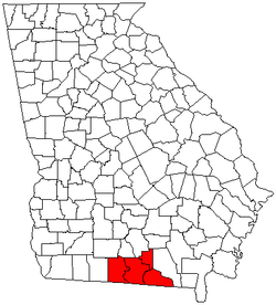
, is an area consisting of four counties – Brooks
Brooks County, Georgia
Brooks County is a county located in the U.S. state of Georgia. It is part of the Valdosta, Georgia Metropolitan Statistical Area. As of 2010, the population was 16,243. The county seat is Quitman...
, Echols
Echols County, Georgia
Echols County is a county located in the U.S. state of Georgia. It is part of the Valdosta, Georgia Metropolitan Statistical Area. As of 2000, the population is 3,754. The 2007 Census Estimate shows a population of 4,093. The county seat is Statenville...
, Lanier
Lanier County, Georgia
Lanier County is a county located in the U.S. state of Georgia. It is part of the Valdosta, Georgia Metropolitan Statistical Area. As of 2009, the population was 8,423. The 2007 Census Estimate shows a population of 7,847. The county seat is Lakeland. Lakeland is Lanier County's only incorporated...
, and Lowndes
Lowndes County, Georgia
Lowndes County is a county located in the U.S. state of Georgia along the Florida border. It was created December 23, 1825. The 2010 Census showed a population of 109,233...
– in south-central Georgia
Georgia (U.S. state)
Georgia is a state located in the southeastern United States. It was established in 1732, the last of the original Thirteen Colonies. The state is named after King George II of Great Britain. Georgia was the fourth state to ratify the United States Constitution, on January 2, 1788...
, anchored by the city of Valdosta
Valdosta, Georgia
Valdosta is the county seat of Lowndes County, Georgia, United States. It is the principal city of the Valdosta Metropolitan Statistical Area. As of the 2010 Census, the city had a total population of 54,518. The Valdosta metropolitan area, according to the 2010 estimate, has a population of 139,588...
. As of the 2010 census
United States Census, 2010
The Twenty-third United States Census, known as Census 2010 or the 2010 Census, is the current national census of the United States. National Census Day was April 1, 2010 and is the reference date used in enumerating individuals...
, the MSA had a population of 139,588.
Counties
- BrooksBrooks County, GeorgiaBrooks County is a county located in the U.S. state of Georgia. It is part of the Valdosta, Georgia Metropolitan Statistical Area. As of 2010, the population was 16,243. The county seat is Quitman...
- EcholsEchols County, GeorgiaEchols County is a county located in the U.S. state of Georgia. It is part of the Valdosta, Georgia Metropolitan Statistical Area. As of 2000, the population is 3,754. The 2007 Census Estimate shows a population of 4,093. The county seat is Statenville...
- LanierLanier County, GeorgiaLanier County is a county located in the U.S. state of Georgia. It is part of the Valdosta, Georgia Metropolitan Statistical Area. As of 2009, the population was 8,423. The 2007 Census Estimate shows a population of 7,847. The county seat is Lakeland. Lakeland is Lanier County's only incorporated...
- LowndesLowndes County, GeorgiaLowndes County is a county located in the U.S. state of Georgia along the Florida border. It was created December 23, 1825. The 2010 Census showed a population of 109,233...
Communities
- Places with more than 40,000 inhabitants
- ValdostaValdosta, GeorgiaValdosta is the county seat of Lowndes County, Georgia, United States. It is the principal city of the Valdosta Metropolitan Statistical Area. As of the 2010 Census, the city had a total population of 54,518. The Valdosta metropolitan area, according to the 2010 estimate, has a population of 139,588...
(Principal city)
- Valdosta
- Places with 1,000 to 5,000 inhabitants
- LakelandLakeland, GeorgiaLakeland is a city in Lanier County, Georgia, United States. The city is the county seat of Lanier County. It is part of the Valdosta, Georgia Metropolitan Statistical Area. The population was 2,730 at the 2000 census....
- QuitmanQuitman, GeorgiaThis article is about the Georgia city. For the county in the same state see Quitman County, Georgia.Quitman is a city in Brooks County, Georgia, United States. The population was 4,638 at the 2000 census. The city is the county seat of Brooks County....
- HahiraHahira, GeorgiaHahira is a city in Lowndes County, Georgia, United States. The estimate population as of July 2009 is 2,328. The population was 1,626 at the 2000 census. Hahira is led by Mayor Wayne Bullard and four members of the elected City Council...
- Lakeland
- Places with less than 1,000 inhabitants
- BarwickBarwick, GeorgiaBarwick is a town divided by the county line between Brooks County and Thomas County, Georgia, United States. It is part of the Valdosta, Georgia Metropolitan Statistical Area.The population was 444 at the 2000 census – 328 of the town's 444 residents lived in Thomas County and 116 in...
(partial) - DasherDasher, GeorgiaDasher is a town in Lowndes County, Georgia, United States. The population was 834 at the 2000 census.-Geography:Dasher is located at ....
- Lake ParkLake Park, GeorgiaLake Park is a city in Lowndes County, Georgia, United States. The population was 549 at the 2000 census.-Geography:Lake Park is located at ....
- Moody AFB (census-designated place)
- MorvenMorven, GeorgiaMorven is a city in Brooks County, Georgia, United States. It is part of the Valdosta, Georgia Metropolitan Statistical Area. The city was named after a mountain in Scotland. The population was 634 at the 2000 census.- History :...
- PavoPavo, GeorgiaPavo is a city that is divided by the county line between Brooks County and Thomas County, Georgia. It is part of the Valdosta, Georgia Metropolitan Statistical Area...
(partial) - RemertonRemerton, GeorgiaRemerton is a city in Lowndes County, Georgia, United States. The population was 1,123 at the 2010 census. It was incorporated as a town in 1951, and chartered as a city under Georgia law in 2000....
- Barwick
- Unincorporated places
- Barney
- Clyattville
- Dixie
- GroovervilleGrooverville, GeorgiaGroovervile is an unincorporated community in Brooks County, Georgia, United States.-Geography:Grooverville is located at .It is a circular area radius from the crossing of Liberty Church Road and Grooverville Road :...
- Mineola
- Naylor
- StatenvilleStatenville, GeorgiaStatenville is an unincorporated community in and the county seat of Echols County, Georgia, United States. Statenville is named for Capt. James W. Staten, who built the first store in the town. Statenville was previously known as Troublesome...
- StocktonStockton, GeorgiaStockton is an unincorporated community in Lanier County, Georgia, United States. In 2007, it had an estimated population of 1,680. Since 2000, it has had a population growth of 6.10 percent....
Highways
There are many signed highways in the area: Interstate 75Interstate 75 in GeorgiaIn the U.S. state of Georgia, Interstate 75 runs north–south along the U.S. Route 41 corridor on the western side of the state, passing through the cities of Valdosta, Macon and Atlanta. It is also designated — but not signed — as State Route 401...
(co-signed as GA 401) U.S. Route 41U.S. Route 41U.S. Route 41 is a north–south United States Highway that runs from Miami, Florida to the Upper Peninsula of Michigan. Until 1949, the part in southern Florida, from Naples to Miami, was U.S...
(North Valdosta Road) (co-signed with I-75 between Exits 22 and 60)
 U.S. Route 84U.S. Route 84 in GeorgiaU.S. Route 84 in Georgia, is also signed as State Route 38 for its entire length in Georgia. After entering Georgia from Alabama west of Jakin, Georgia, the route travels through the southern portion of the state, meeting its eastern terminus at Interstate 95 east of Midway. U.S...
(Hill Avenue (Valdosta), Wiregrass Parkway) U.S. Route 129U.S. Route 129U.S. Route 129 is an offshoot route of U.S. Route 29, which it intersects near Athens, Georgia. US 129 currently runs for 582 miles from Knoxville, Tennessee, to Chiefland, Florida, at U.S. Route 19 and U.S. Route 98. It passes through the states of Tennessee, North Carolina, Georgia and Florida...
 U.S. Route 221U.S. Route 221U.S. Route 221 is a spur of U.S. Route 21. It runs for 734 miles from Perry, Florida at US Routes 19/98/ALT 27 to Lynchburg, Virginia at U.S. Route 29 . It passes through the states of Florida, Georgia, South Carolina, North Carolina, and Virginia...
(co-signed with US 84) U.S. Route 441U.S. Route 441U.S. Route 441 is a spur route of U.S. Route 41. It currently runs for 939 miles from U.S. Route 41 in Miami, Florida to U.S. Route 25W in Lake City, Tennessee. Between its termini, US 441 passes through the states of Florida, Georgia, North Carolina, and Tennessee...
 Georgia State Route 7Georgia State Route 7State Route 7 is a north–south route located in the U.S. state of Georgia. The route is cosigned with either U.S. 41 or U.S. 341 for its entire length.-Routing:...
(co-signed with US 41)(Used to be Ashley St(NB)and Patterson St(SB), now they are ALT SR7) Georgia State Route 11Georgia State Route 11State Route 11 runs the entire length of the U.S. state of Georgia. It is the longest route in the state. The route begins at the Florida state line south of Statenville. The route travels north cosigned with US 129 through Statenville, Lakeland, Nashville, Ocilla, Fitzgerald, and Abbeville, before...
 Georgia State Route 31Georgia State Route 31State Route 31 is a north–south state route located in the central and southern parts of the U.S. state of Georgia. The route travels from Florida State Road 145 at the Florida state line south of Clyattville to SR 15/SR 57/SR 78 in Wrightsville....
 Georgia State Route 37Georgia State Route 37State Route 37 is a west–east state route located in the southern part of the U.S. state of Georgia. The route travels from Alabama State Route 10 at the Alabama state line west of Fort Gaines east to U.S...
 Georgia State Route 64Georgia State Route 64Georgia State Route 64 is a highway located in southern Georgia that runs from U.S. Route 129 in Ray City to State Route 158 in rural Coffee County.- Routing :...
 Georgia State Route 76
 Georgia State Route 89
 Georgia State Route 94Georgia State Route 94State Route 94 is a state route in the U.S. state of Georgia in Lowndes, Echols, Clinch, and Charlton counties. It is long , from Valdosta to the Florida state line in Saint George, and the road continues as Florida State Road 2. It is a major highway of southeastern Georgia and extreme northern...
 Georgia State Route 122Georgia State Route 122State Route 122 is a East–West route located in the U.S. state of Georgia. The route runs from its Eastern terminus at US 1/SR 4/US 23/US 84/SR 38 in Waycross West to its Western terminus at US 19/SR 3/US 84/SR 38/SR 300 in Thomasville....
(Main Street (Hahira, Lakeland)) Georgia State Route 125Georgia State Route 125Georgia State Route 125 is a Georgia state route. In Valdosta, it is called Bemiss Road and runs next to Moody Air Force Base....
(Bemiss Road (Lowndes County)) Georgia State Route 133Georgia State Route 133State Route 133 is a north–south state highway in southwestern Georgia. In fact, the actual path taken is more southeast to northwest. The route begins in Valdosta, GA on a northwesterly jaunt through Lowndes County and Brooks County before reaching Moultrie, GA. From here, the route heads...
(Billy Langdale Parkway, St. Augustine Road (Valdosta)) Georgia State Route 135
 Georgia State Route 187
 Georgia State Route 333 (Moultrie Road (Brooks County))
 Georgia State Route 376
Airports
There are a two airports in the area:- Quitman Brooks County Airport (General aviation)
- Valdosta Regional AirportValdosta Regional AirportValdosta Regional Airport is a public-use airport located three nautical miles south of the central business district of Valdosta, a city in Lowndes County, Georgia, United States. It is owned by the Valdosta-Lowndes County Airport Authority...
(VLD, KVLD) (Commercial service to Hartsfield-Jackson Atlanta International AirportHartsfield-Jackson Atlanta International AirportHartsfield–Jackson Atlanta International Airport , known locally as Atlanta Airport, Hartsfield Airport, and Hartsfield–Jackson, is located seven miles south of the central business district of Atlanta, Georgia, United States...
)
Demographics
As of the censusCensus
A census is the procedure of systematically acquiring and recording information about the members of a given population. It is a regularly occurring and official count of a particular population. The term is used mostly in connection with national population and housing censuses; other common...
of 2000, there were 119,560 people, 42,666 households, and 29,474 families residing in the MSA. The racial makeup of the MSA was 62.42% White, 33.37% African American, 0.40% Native American, 0.98% Asian, 0.04% Pacific Islander, 1.54% from other races
Race (United States Census)
Race and ethnicity in the United States Census, as defined by the Federal Office of Management and Budget and the United States Census Bureau, are self-identification data items in which residents choose the race or races with which they most closely identify, and indicate whether or not they are...
, and 1.25% from two or more races. Hispanic or Latino of any race were 3.19% of the population.
The median income for a household in the MSA was $28,516, and the median income for a family was $34,044. Males had a median income of $26,347 versus $19,250 for females. The per capita income for the MSA was $15,019.
See also
- Georgia census statistical areasGeorgia census statistical areasThe United States Census Bureau has defined 5 Combined Statistical Areas , 15 Metropolitan Statistical Areas , and 24 Micropolitan Statistical Areas in the State of Georgia. The following table describes these areas with the following information:*The name of the Combined Statistical Area , if...
- List of cities in Georgia
- List of towns and villages in Georgia