
Georgia State Route 37
Encyclopedia
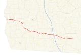
State Route 37 is a west–east state route located in the southern part of the U.S. state
of Georgia
. The route travels from Alabama State Route 10
at the Alabama
state line west of Fort Gaines
east to U.S. Route 84
/State Route 38
west of Homerville
.
and Calhoun County
. In the county seat of Calhoun County, Morgan
, the route takes a turn to the southeast, passing through Baker County
, and its seat, Newton
, before entering Mitchell County
. In Camilla
, the route resumes its easterly routing, passing through the cities of Moultrie
and Adel
, where it has an interchange with Interstate 75
/State Route 401. In Ray City
, State Route 37 becomes cosigned
with U.S. Route 129
/State Route 11
to Lakeland
, where U.S. Route 221
and State Route 31
join the cosignage. Just east of Lakeland, the routes split, with U.S. 129/SR 11 continuing south and U.S. 221/SR 31 continuing north. State Route 37 continues east into Clinch County
, where it meets its eastern terminus at U.S. Route 84/SR 38 west of Homerville.
State Route 37 is largely a remote, rural route, with an Average Annual Daily Traffic of less than 5,000 vehicles for most of its length, except around Adel and the cosignage with U.S. Routes 129 and 221 east of Lakeland.
near the Courthouse.
Georgia State Route 37 Connector – Lakeland, a short road connecting State Route 37 with U.S. Route 129 just east of Lakeland.
U.S. state
A U.S. state is any one of the 50 federated states of the United States of America that share sovereignty with the federal government. Because of this shared sovereignty, an American is a citizen both of the federal entity and of his or her state of domicile. Four states use the official title of...
of Georgia
Georgia (U.S. state)
Georgia is a state located in the southeastern United States. It was established in 1732, the last of the original Thirteen Colonies. The state is named after King George II of Great Britain. Georgia was the fourth state to ratify the United States Constitution, on January 2, 1788...
. The route travels from Alabama State Route 10
Alabama State Route 10
State Route 10 is an east–west route in southern Alabama. It is the lowest even numbered route in the state that is not an unsigned partner route assigned to a U.S. highway. It is also the only signed state route that extends from the Mississippi state line to the Georgia line...
at the Alabama
Alabama
Alabama is a state located in the southeastern region of the United States. It is bordered by Tennessee to the north, Georgia to the east, Florida and the Gulf of Mexico to the south, and Mississippi to the west. Alabama ranks 30th in total land area and ranks second in the size of its inland...
state line west of Fort Gaines
Fort Gaines, Georgia
Fort Gaines is a city in Clay County, Georgia, United States. The population was 1,110 at the 2000 census. The city is the county seat of Clay County.-Geography:Fort Gaines is located at ....
east to U.S. Route 84
U.S. Route 84
U.S. Route 84 is an east–west United States highway. It started as a short Georgia-Alabama route in the original 1926 scheme, but now extends all the way to Colorado. The highway's eastern terminus is a short distance east of Midway, Georgia, at an intersection with I-95. The road continues...
/State Route 38
U.S. Route 84 in Georgia
U.S. Route 84 in Georgia, is also signed as State Route 38 for its entire length in Georgia. After entering Georgia from Alabama west of Jakin, Georgia, the route travels through the southern portion of the state, meeting its eastern terminus at Interstate 95 east of Midway. U.S...
west of Homerville
Homerville, Georgia
Homerville is a city in Clinch County, Georgia, United States. The population was 2,803 at the 2000 census. The city is the county seat of Clinch County. Homerville was incorporated February 15, 1869.-Geography:...
.
Route description
From its western terminus at the Alabama state line, the route travels east, through Fort Gaines, and through generally rural areas of Clay CountyClay County, Georgia
Clay County is a county located in the U.S. state of Georgia. As of 2000, the population was 3,357. The 2007 Census Estimate shows a population of 3,207...
and Calhoun County
Calhoun County, Georgia
Calhoun County is a county located in the U.S. state of Georgia. It was created on February 20, 1854. As of 2000, the population was 6,320. The 2007 Census Estimate shows a population of 6,098...
. In the county seat of Calhoun County, Morgan
Morgan, Georgia
Morgan is a city in Calhoun County, Georgia, United States. The population was 1,464 at the 2000 census. The city is the county seat of Calhoun County.-Geography:Morgan is located at ....
, the route takes a turn to the southeast, passing through Baker County
Baker County, Georgia
Baker County is a county in the U.S. state of Georgia. , the population is 4,074. The 2007 Census Estimate placed the population at 3,781. The county seat is Newton.Baker County is included in the Albany, Georgia Metropolitan Statistical Area.-History:...
, and its seat, Newton
Newton, Georgia
Newton is a city in Baker County, Georgia, in the United States. As of the 2000 census, the city population was 851. The city is the county seat of Baker County.-Geography:Newton is located at ....
, before entering Mitchell County
Mitchell County, Georgia
Mitchell County is a county located in the U.S. state of Georgia. It was created on December 21, 1857. As of 2000, the population was 23,932. The 2007 Census Estimate showed a population of 24,139. The county seat is Camilla.-Geography:...
. In Camilla
Camilla, Georgia
As of the census of 2000, there were 5,669 people, 1,994 households, and 1,405 families residing in the city. The population density was 929.4 people per square mile . There were 2,128 housing units at an average density of 348.9 per square mile...
, the route resumes its easterly routing, passing through the cities of Moultrie
Moultrie, Georgia
Moultrie is the county seat and largest city of Colquitt County and the third largest in Southwest Georgia behind Thomasville and Albany. As of 2009, Moultrie's population is 15,199 people. Since 2000, it has had a population growth of 6.07 percent....
and Adel
Adel, Georgia
Adel is a city in Cook County, Georgia, United States. As of the 2010 census, the city had a population of 5,344. The city is the county seat of Cook County. The original name of the city was Puddleville. The city's first postmaster, Joel "Uncle Jack" Parrish, wanted to change the name of the city...
, where it has an interchange with Interstate 75
Interstate 75 in Georgia
In the U.S. state of Georgia, Interstate 75 runs north–south along the U.S. Route 41 corridor on the western side of the state, passing through the cities of Valdosta, Macon and Atlanta. It is also designated — but not signed — as State Route 401...
/State Route 401. In Ray City
Ray City, Georgia
Ray City is a city in Berrien County, Georgia, United States. The population was 1,090 at the 2010 census.-Geography:Ray City is located at ....
, State Route 37 becomes cosigned
Concurrency (road)
A concurrency, overlap, or coincidence in a road network is an instance of one physical road bearing two or more different highway, motorway, or other route numbers...
with U.S. Route 129
U.S. Route 129
U.S. Route 129 is an offshoot route of U.S. Route 29, which it intersects near Athens, Georgia. US 129 currently runs for 582 miles from Knoxville, Tennessee, to Chiefland, Florida, at U.S. Route 19 and U.S. Route 98. It passes through the states of Tennessee, North Carolina, Georgia and Florida...
/State Route 11
Georgia State Route 11
State Route 11 runs the entire length of the U.S. state of Georgia. It is the longest route in the state. The route begins at the Florida state line south of Statenville. The route travels north cosigned with US 129 through Statenville, Lakeland, Nashville, Ocilla, Fitzgerald, and Abbeville, before...
to Lakeland
Lakeland, Georgia
Lakeland is a city in Lanier County, Georgia, United States. The city is the county seat of Lanier County. It is part of the Valdosta, Georgia Metropolitan Statistical Area. The population was 2,730 at the 2000 census....
, where U.S. Route 221
U.S. Route 221
U.S. Route 221 is a spur of U.S. Route 21. It runs for 734 miles from Perry, Florida at US Routes 19/98/ALT 27 to Lynchburg, Virginia at U.S. Route 29 . It passes through the states of Florida, Georgia, South Carolina, North Carolina, and Virginia...
and State Route 31
Georgia State Route 31
State Route 31 is a north–south state route located in the central and southern parts of the U.S. state of Georgia. The route travels from Florida State Road 145 at the Florida state line south of Clyattville to SR 15/SR 57/SR 78 in Wrightsville....
join the cosignage. Just east of Lakeland, the routes split, with U.S. 129/SR 11 continuing south and U.S. 221/SR 31 continuing north. State Route 37 continues east into Clinch County
Clinch County, Georgia
Clinch County is a county located in the U.S. state of Georgia. It was created on February 14, 1850, named in honor of Duncan Lamont Clinch. As of 2000, the population is 6,878. The 2007 Census Estimate shows a population of 6,992...
, where it meets its eastern terminus at U.S. Route 84/SR 38 west of Homerville.
State Route 37 is largely a remote, rural route, with an Average Annual Daily Traffic of less than 5,000 vehicles for most of its length, except around Adel and the cosignage with U.S. Routes 129 and 221 east of Lakeland.
Related routes
Georgia State 37 Connector – Camilla, a short road in the city of Camilla with State Route 112Georgia State Route 112
State Route 112 is a Georgia state highway that runs in a generally north–south orientation from Milledgeville in Baldwin County to Cairo in Grady County.-Route description:...
near the Courthouse.
Georgia State Route 37 Connector – Lakeland, a short road connecting State Route 37 with U.S. Route 129 just east of Lakeland.