
Upfield bike path
Encyclopedia
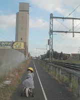
The Upfield Bike Path is a shared use path for cyclists
and pedestrian
s, which follows Upfield railway line through the inner northern suburbs of Melbourne
, Victoria
, Australia
.
It stretches from Princes Park
, through Brunswick
and Coburg
, to Box Forest Road, Fawkner
, just south of Gowrie railway station. It was originally opened in the late 1980s.
Missing links have been progressively filled with the work between Hope Street and Anstey railway station in Brunswick completed in August 2002. A section between Reynard and O'Hea Streets in Coburg
with a signalled crossing at Bell Street was completed by 2006 by City of Moreland
Council and VicRoads
. An extension to Box Forest Road was completed in September 2008.
on the old Inner Circle railway line reservation which provides access to the Merri Creek Trail
at Rushall railway station
; and in the other direction it passes near the Royal Melbourne Zoological Gardens
before connecting with the Moonee Ponds Creek Trail
.
Alternatively, at Park Street cyclists can join the Royal Parade bike path and on road bike lane which provides access to University of Melbourne
main campus in Parkville
.
City of Moreland
Council has reported the number of people counted riding on the Upfield Bike Path and Sydney Road
at Park Street has almost quadrupled from 1992 to 2003. The 24hr weekday average was 804 in Feb 2008.
The Upfield path parallels Sydney Road
shopping strip in Brunswick
and Coburg
, and is often used by pedestrians and cyclists for shopping, dog walking as well as commuter cycling.
Historic buildings along the path include the Brunswick Baths at Dawson Street and the Railway Hotel (now a Backpackers Hostel) at Albert Street, Brunswick.
in May 2007. However they did not make use of a color schema as seen on the Upfield Bike path.
Previously the path was without lights and unfriendly to riders. The new array of red LED on the left and white LED on the right, creates a delineated "airport runway" style, visually stunning, lighting grid, providing up to 600 meters of visible pathway for riders, even at the darkest hours. Hazards are indicated using amber LED.
For safety, the lights are mounted flush with the ground where they absorb more than enough energy, stored in their environmentally friendly super capacitors during daylight, to provide up to 14 hours of continuous lighting.
The Western Ring Road Trail
is 3 km to the north, up Sydney Rd, from the most northerly end of the trail.
North end at 37.719074°S 144.961295°E.
South end at 37.780251°S 144.957067°E.
Cycling
Cycling, also called bicycling or biking, is the use of bicycles for transport, recreation, or for sport. Persons engaged in cycling are cyclists or bicyclists...
and pedestrian
Pedestrian
A pedestrian is a person traveling on foot, whether walking or running. In some communities, those traveling using roller skates or skateboards are also considered to be pedestrians. In modern times, the term mostly refers to someone walking on a road or footpath, but this was not the case...
s, which follows Upfield railway line through the inner northern suburbs of Melbourne
Melbourne
Melbourne is the capital and most populous city in the state of Victoria, and the second most populous city in Australia. The Melbourne City Centre is the hub of the greater metropolitan area and the Census statistical division—of which "Melbourne" is the common name. As of June 2009, the greater...
, Victoria
Victoria (Australia)
Victoria is the second most populous state in Australia. Geographically the smallest mainland state, Victoria is bordered by New South Wales, South Australia, and Tasmania on Boundary Islet to the north, west and south respectively....
, Australia
Australia
Australia , officially the Commonwealth of Australia, is a country in the Southern Hemisphere comprising the mainland of the Australian continent, the island of Tasmania, and numerous smaller islands in the Indian and Pacific Oceans. It is the world's sixth-largest country by total area...
.
It stretches from Princes Park
Princes Park, Carlton
Princes Park is a 38.6 hectare park in the inner-Melbourne suburb of Carlton North, Victoria. It is located directly north of the University of Melbourne and bounded on its eastern and western sides by Melbourne General Cemetery and Royal Parade respectively...
, through Brunswick
Brunswick, Victoria
Brunswick is a suburb in Melbourne, Victoria, Australia, 6 km north from Melbourne's central business district. Its Local Government Area is the City of Moreland...
and Coburg
Coburg, Victoria
Coburg is a suburb in Melbourne, Victoria, Australia, 8 km north from Melbourne's central business district. Its Local Government Area is the City of Moreland, although a handful of properties on Coburg's Eastern boundary are located in the City of Darebin...
, to Box Forest Road, Fawkner
Fawkner, Victoria
Fawkner is a suburb in Melbourne, Victoria, Australia, 12 km north from Melbourne's central business district. Its Local Government Area is the City of Moreland...
, just south of Gowrie railway station. It was originally opened in the late 1980s.
Missing links have been progressively filled with the work between Hope Street and Anstey railway station in Brunswick completed in August 2002. A section between Reynard and O'Hea Streets in Coburg
Coburg, Victoria
Coburg is a suburb in Melbourne, Victoria, Australia, 8 km north from Melbourne's central business district. Its Local Government Area is the City of Moreland, although a handful of properties on Coburg's Eastern boundary are located in the City of Darebin...
with a signalled crossing at Bell Street was completed by 2006 by City of Moreland
City of Moreland
The City of Moreland is a Local Government Area located within the metropolitan area of Melbourne, Victoria, Australia. It comprises the inner northern suburbs between 4 and 10 kilometres from the Melbourne city centre....
Council and VicRoads
VicRoads
VicRoads or the Roads Corporation of Victoria is a statutory corporation which is the state road and traffic authority in the state of Victoria, Australia. It is responsible for maintenance and construction of the state arterial road network, as well as driver licensing and vehicle registration. ...
. An extension to Box Forest Road was completed in September 2008.
Following the path
The southern end of the Upfield Bike Path connects to the Capital City TrailCapital City Trail
The Capital City Trail is a shared use path for cyclists and pedestrians, which circles the Melbourne city centre and some inner eastern and northern suburbs of Melbourne, Victoria, Australia....
on the old Inner Circle railway line reservation which provides access to the Merri Creek Trail
Merri Creek Trail
The Merri Creek Trail is a shared use path for cyclists and pedestrians, which follows the Merri Creek through the northern suburbs of Melbourne, Victoria, Australia.-Following the Path:...
at Rushall railway station
Rushall railway station
Rushall railway station was a station on the South Staffordshire Line. It was opened in 1849. It was the first station to fall on the line, closing in 1909...
; and in the other direction it passes near the Royal Melbourne Zoological Gardens
Melbourne Zoo
The Royal Melbourne Zoological Gardens, commonly known as the Melbourne Zoo, contains more than 320 animal species from Australia and around the world. The zoo is north of the centre of Melbourne. It is accessible via Royal Park station on the Upfield railway line, and is also accessible via tram...
before connecting with the Moonee Ponds Creek Trail
Moonee Ponds Creek Trail
The Moonee Ponds Creek Trail is a shared use path for cyclists and pedestrians, which follows the Moonee Ponds Creek through the northern suburbs of Melbourne, Victoria, Australia.-Following the path:...
.
Alternatively, at Park Street cyclists can join the Royal Parade bike path and on road bike lane which provides access to University of Melbourne
University of Melbourne
The University of Melbourne is a public university located in Melbourne, Victoria. Founded in 1853, it is the second oldest university in Australia and the oldest in Victoria...
main campus in Parkville
Parkville, Victoria
Parkville is an inner city suburb in Melbourne, Victoria, Australia, 3 km north from Melbourne's central business district. Its Local Government Area is the City of Melbourne. At the 2006 Census, the population was 4,980....
.
City of Moreland
City of Moreland
The City of Moreland is a Local Government Area located within the metropolitan area of Melbourne, Victoria, Australia. It comprises the inner northern suburbs between 4 and 10 kilometres from the Melbourne city centre....
Council has reported the number of people counted riding on the Upfield Bike Path and Sydney Road
Sydney Road, Melbourne
Sydney Road is a major urban arterial in the northern suburbs of Melbourne, Victoria, Australia.-Geography:...
at Park Street has almost quadrupled from 1992 to 2003. The 24hr weekday average was 804 in Feb 2008.
The Upfield path parallels Sydney Road
Sydney Road, Melbourne
Sydney Road is a major urban arterial in the northern suburbs of Melbourne, Victoria, Australia.-Geography:...
shopping strip in Brunswick
Brunswick, Victoria
Brunswick is a suburb in Melbourne, Victoria, Australia, 6 km north from Melbourne's central business district. Its Local Government Area is the City of Moreland...
and Coburg
Coburg, Victoria
Coburg is a suburb in Melbourne, Victoria, Australia, 8 km north from Melbourne's central business district. Its Local Government Area is the City of Moreland, although a handful of properties on Coburg's Eastern boundary are located in the City of Darebin...
, and is often used by pedestrians and cyclists for shopping, dog walking as well as commuter cycling.
Historic buildings along the path include the Brunswick Baths at Dawson Street and the Railway Hotel (now a Backpackers Hostel) at Albert Street, Brunswick.
Solar lighting at Fawkner Cemetery
The Upfield Path section, passing the Fawkner Cemetery, was upgraded in February 2009 to include the world's first shared-pathway, solar lighting schema. Stonnington City Council introduced solar lighting on the Gardiners Creek TrailGardiners Creek Trail
The Gardiners Creek Trail is a shared use path for cyclists and pedestrians, which follows Gardiners Creek through the eastern suburbs of Melbourne, Victoria, Australia....
in May 2007. However they did not make use of a color schema as seen on the Upfield Bike path.
Previously the path was without lights and unfriendly to riders. The new array of red LED on the left and white LED on the right, creates a delineated "airport runway" style, visually stunning, lighting grid, providing up to 600 meters of visible pathway for riders, even at the darkest hours. Hazards are indicated using amber LED.
For safety, the lights are mounted flush with the ground where they absorb more than enough energy, stored in their environmentally friendly super capacitors during daylight, to provide up to 14 hours of continuous lighting.
Connections
- The path comes to a dead end in the north at Box Forest Road at Fawkner cemetery.
- It meets the Capital City TrailCapital City TrailThe Capital City Trail is a shared use path for cyclists and pedestrians, which circles the Melbourne city centre and some inner eastern and northern suburbs of Melbourne, Victoria, Australia....
in the south.
The Western Ring Road Trail
Western Ring Road Trail
The Western Ring Road Trail is a shared use path for cyclists and pedestrians that bridges the northern suburbs and follows the Western Ring Road...
is 3 km to the north, up Sydney Rd, from the most northerly end of the trail.
North end at 37.719074°S 144.961295°E.
South end at 37.780251°S 144.957067°E.