
Unrecognized villages
Encyclopedia
The term Unrecognized Bedouin villages in Israel refers to Arab
villages in the Negev
and the Galilee
which the Israel
i government does not recognize as legal settlements. Approximately half of Bedouin citizens of Israel live in 39-45 such villages. According to the Israel Land Administration
, in 2007 40% of the Bedouin lived in Unrecognized villages, although the Regional Council of Unrecognized Villages
(RCUV) refers to Bedouin in unrecognized villages as half the Negev Bedouin population. The unrecognised villages are ineligible for municipal services such as connection to the electrical grid, water mains or trash-pickup. The Israeli NGO "Adva Center" published a report on this issue saying, "The Bedouin living in the Negev constitute the only group of Arab citizens of Israel that still has a large-scale hold on the land, a hold that the state officially denies in principle, while recognizing in practice." Homes in the villages have been subject to demolition by the Israeli authorities. The unrecognized villages are not precisely marked on any commercial maps.
 During the 19th century and the first half of the 20th century, the semi-arid region of the Negev was inhabited mostly by semi-nomadic Bedouin tribes. This population became more and more sedentarized, and by the turn of the 20th century many of them lived in small agricultural communities. According to the Goldberg Report, territorial boundaries between Bedouin tribes and claims on lands in the Negev region were not recorded by the Ottoman authorities
until 1896, and yet even after that year, it was unclear (and practically unimportant) whether the local law saw these lands as fully owned by the Bedouin. The report further says that the successive British authorities recognized the land arrangements of the previous Ottoman rule, but in 1934 they conducted a land survey and registration and began to collect taxes on land ownership. In the early 1940s the British Mandate government estimated the number of Bedouin around Beersheba
at 66.5 thousands, irrigating approximately two million dunam
s (2,000 sq km).
During the 1948 Arab–Israeli War, the Negev regions saw harsh battles between the newly created Israel Defense Forces
and the Egyptian army
. In the aftermath of the war, most of the Negev was included within the borders of the newly established State of Israel. Censuses before and after the war indicate that about 80% of the Bedouin population left the Negev to areas that remained under Arab rule.
The Israeli authorities' treatment of the Bedouin population was ambivalent. On the one hand, the Bedouin were considered loyal to the new state, and some of them even volunteered to serve in the IDF. On the other hand, Israel saw the Negev as its "hinterland
", being sparsely populated and as the West Bank
came under Jordanian rule. The policy eventually adopted was forcing the Bedouin to concentrate in an area of 1,100 sq km, that has become known as the Siyagh region, stretching between the West Bank border to the north east, Beersheba to the south west and Arad to the south. All Bedouin remaining under Israeli rule were granted Israeli citizenship, but the Siyagh region region was placed under martial law until 1966, like many other mostly Arab-populated areas in Israel at the time.
The Bedouin claims for ownership on lands in the Negev were, by and large, rejected by the Israeli authorities, on the pretext that the ownership is not appropriately documented or that the lands claimed are not eligible to private ownership. Both Bedouin citizens and state authorities agree that only a small minority of the claim can be backed with full legally valid documentation, however the Bedouin claimant demand that their traditional ties with the lands, namely the fact that they de facto held the rights on these lands without objection on behalf of the former Ottoman or British authorities, be recognized by the State of Israel as ownership. Prof. Oren Yiftachel, a member of the geography department at Ben-Gurion University of the Negev and an advocate for Bedouin rights, told the New York Times, "In pure legal terms, the state has a point, but it is a very technical point, brushing aside tradition and the legal occupation of the land until the 1950s".
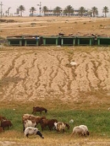
In order to reinforce the invisible Siyag fence, the State employed a reining mechanism, the Black Goat Law of 1950. The Black Goat Law curbed grazing so as to prevent land erosion, prohibiting the grazing of goats outside recognized land holdings. Since few Bedouin territorial claims were recognized, most grazing was thereby rendered illegal. Both Ottoman
and British
land registration processes failed to reach into the Negev region. Most Bedouin who had the option, preferred not to register their lands as this would mean being taxed without representation or services. Those whose land claims were recognized found it almost impossible to keep their goats within the periphery of their newly limited range. Into the 1970s and 1980s, only a small portion of the Bedouin were able to continue to graze their goats. Instead of migrating with their goats in search of pasture, the majority of the Bedouin migrated in search of wage-labor.
The Israeli government has promoted the sedentarization of the Bedouin population. In 1963, Moshe Dayan
said:
Dayan added, "Without coercion but with governmental direction ... this phenomenon of the Bedouins will disappear."
In 1979 Agriculture Minister Ariel Sharon
declared a 1,500 square kilometer area in the Negev a protected nature reserve, rendering a major portion of the Negev almost entirely out of bounds for Bedouin herders. In conjunction, he established the Green Patrol, which has been called an 'environmental paramilitary unit', with the mission of fighting Bedouin 'infiltration' into national Israeli land by preventing Bedouin from grazing their animals, seen as creating 'facts on the ground
.' During Sharon's tenure as Minister of Agriculture (1977–1981), the Green Patrol removed 900 Bedouin encampments and cut goat herds by more than 1/3. Today the black goat
is nearly extinct, and Bedouin in Israel do not have enough access to black goat hair to weave tents.
, few of the Bedouin in unrecognized villages see the urban townships as a desirable form of settlement.
.
In the portion of the Negev available for civilian purposes, a large number of citizens live together in close proximity to a range of types of hazardous infrastructure. In the past few decades both Bedouin and Jews of the region have come to share some 2.5 % of the desert with Israel's nuclear reactor
s, 22 agro and petrochemical factories, an oil terminal, closed military zones, quarries, a toxic waste incinerator (Ramat Hovav
), cell towers, a power plant, several airports, a prison, and 2 rivers of open sewage. Much of this infrastructure is concentrated on the grounds of the unrecognized village of Wadi el-Na'am
.
in the Bedouin sector a "security threat" and advocated various means of reducing the Arab birth rate. In 2003, Shai Hermesh
, the treasurer of the Jewish Agency and head of its effort to establish a solid Jewish majority in the desert told The Guardian: "We need the Negev for the next generation of Jewish immigrants" and added, "It is not in Israel's interest to have more Palestinians in the Negev."
In 2005 Ronald Lauder
of the Jewish National Fund
announced plans to bring 250,000–500,000 people into the Negev through the Blueprint Negev
, incurring opposition from Bedouin rights groups concerned that the unrecognized villages might be cleared to make way for Jewish development and potentially ignite internal civil strife. Some Bedouin advocates claim the Blueprint Negev is motivated by demographic considerations, aimed at the increasing Jewish population to offset the skyrocketing Bedouin population.
In 2010, Israeli authorities demolished the unrecognized village of al-Araqeeb
and by January 2011 had demolished structures there an additional eight times after residents attempted to rebuild in the wake of each demolition.
Arab
Arab people, also known as Arabs , are a panethnicity primarily living in the Arab world, which is located in Western Asia and North Africa. They are identified as such on one or more of genealogical, linguistic, or cultural grounds, with tribal affiliations, and intra-tribal relationships playing...
villages in the Negev
Negev
The Negev is a desert and semidesert region of southern Israel. The Arabs, including the native Bedouin population of the region, refer to the desert as al-Naqab. The origin of the word Neghebh is from the Hebrew root denoting 'dry'...
and the Galilee
Galilee
Galilee , is a large region in northern Israel which overlaps with much of the administrative North District of the country. Traditionally divided into Upper Galilee , Lower Galilee , and Western Galilee , extending from Dan to the north, at the base of Mount Hermon, along Mount Lebanon to the...
which the Israel
Israel
The State of Israel is a parliamentary republic located in the Middle East, along the eastern shore of the Mediterranean Sea...
i government does not recognize as legal settlements. Approximately half of Bedouin citizens of Israel live in 39-45 such villages. According to the Israel Land Administration
Israel Land Administration
The Israel Land Administration is part of the government of Israel and is responsible for managing the 93% of the land in Israel which is in the public domain. These lands are either property of the state, belong to the Jewish National Fund which controls 13% of the land, or belong to the Israel...
, in 2007 40% of the Bedouin lived in Unrecognized villages, although the Regional Council of Unrecognized Villages
Regional Council of Unrecognized Villages
The Regional Council of Unrecognized Villages is a democratic representative body for the 80,000-something residents of the Bedouin unrecognized villages of the Negev Desert. The residents of the Bedouin unrecognized villages belong to no municipalities of their own and thus cannot elect...
(RCUV) refers to Bedouin in unrecognized villages as half the Negev Bedouin population. The unrecognised villages are ineligible for municipal services such as connection to the electrical grid, water mains or trash-pickup. The Israeli NGO "Adva Center" published a report on this issue saying, "The Bedouin living in the Negev constitute the only group of Arab citizens of Israel that still has a large-scale hold on the land, a hold that the state officially denies in principle, while recognizing in practice." Homes in the villages have been subject to demolition by the Israeli authorities. The unrecognized villages are not precisely marked on any commercial maps.
History
Ottoman Empire
The Ottoman EmpireIt was usually referred to as the "Ottoman Empire", the "Turkish Empire", the "Ottoman Caliphate" or more commonly "Turkey" by its contemporaries...
until 1896, and yet even after that year, it was unclear (and practically unimportant) whether the local law saw these lands as fully owned by the Bedouin. The report further says that the successive British authorities recognized the land arrangements of the previous Ottoman rule, but in 1934 they conducted a land survey and registration and began to collect taxes on land ownership. In the early 1940s the British Mandate government estimated the number of Bedouin around Beersheba
Beersheba
Beersheba is the largest city in the Negev desert of southern Israel. Often referred to as the "Capital of the Negev", it is the seventh-largest city in Israel with a population of 194,300....
at 66.5 thousands, irrigating approximately two million dunam
Dunam
A dunam or dönüm, dunum, donum, dynym, dulum was a non-SI unit of land area used in the Ottoman Empire and representing the amount of land that can be plowed in a day; its value varied from 900–2500 m²...
s (2,000 sq km).
During the 1948 Arab–Israeli War, the Negev regions saw harsh battles between the newly created Israel Defense Forces
Israel Defense Forces
The Israel Defense Forces , commonly known in Israel by the Hebrew acronym Tzahal , are the military forces of the State of Israel. They consist of the ground forces, air force and navy. It is the sole military wing of the Israeli security forces, and has no civilian jurisdiction within Israel...
and the Egyptian army
Egyptian Army
The Egyptian Army is the largest service branch within the Egyptian Armed Forces and holds power in the current Egyptian government. It is estimated to number around 379,000, in addition to 479,000 reservists for a total of 858,000 strong. The modern army was created in the 1820s, and during the...
. In the aftermath of the war, most of the Negev was included within the borders of the newly established State of Israel. Censuses before and after the war indicate that about 80% of the Bedouin population left the Negev to areas that remained under Arab rule.
The Israeli authorities' treatment of the Bedouin population was ambivalent. On the one hand, the Bedouin were considered loyal to the new state, and some of them even volunteered to serve in the IDF. On the other hand, Israel saw the Negev as its "hinterland
Hinterland
The hinterland is the land or district behind a coast or the shoreline of a river. Specifically, by the doctrine of the hinterland, the word is applied to the inland region lying behind a port, claimed by the state that owns the coast. The area from which products are delivered to a port for...
", being sparsely populated and as the West Bank
West Bank
The West Bank ) of the Jordan River is the landlocked geographical eastern part of the Palestinian territories located in Western Asia. To the west, north, and south, the West Bank shares borders with the state of Israel. To the east, across the Jordan River, lies the Hashemite Kingdom of Jordan...
came under Jordanian rule. The policy eventually adopted was forcing the Bedouin to concentrate in an area of 1,100 sq km, that has become known as the Siyagh region, stretching between the West Bank border to the north east, Beersheba to the south west and Arad to the south. All Bedouin remaining under Israeli rule were granted Israeli citizenship, but the Siyagh region region was placed under martial law until 1966, like many other mostly Arab-populated areas in Israel at the time.
The Bedouin claims for ownership on lands in the Negev were, by and large, rejected by the Israeli authorities, on the pretext that the ownership is not appropriately documented or that the lands claimed are not eligible to private ownership. Both Bedouin citizens and state authorities agree that only a small minority of the claim can be backed with full legally valid documentation, however the Bedouin claimant demand that their traditional ties with the lands, namely the fact that they de facto held the rights on these lands without objection on behalf of the former Ottoman or British authorities, be recognized by the State of Israel as ownership. Prof. Oren Yiftachel, a member of the geography department at Ben-Gurion University of the Negev and an advocate for Bedouin rights, told the New York Times, "In pure legal terms, the state has a point, but it is a very technical point, brushing aside tradition and the legal occupation of the land until the 1950s".
In order to reinforce the invisible Siyag fence, the State employed a reining mechanism, the Black Goat Law of 1950. The Black Goat Law curbed grazing so as to prevent land erosion, prohibiting the grazing of goats outside recognized land holdings. Since few Bedouin territorial claims were recognized, most grazing was thereby rendered illegal. Both Ottoman
Ottoman Empire
The Ottoman EmpireIt was usually referred to as the "Ottoman Empire", the "Turkish Empire", the "Ottoman Caliphate" or more commonly "Turkey" by its contemporaries...
and British
Mandate Palestine
Mandate Palestine existed while the British Mandate for Palestine, which formally began in September 1923 and terminated in May 1948, was in effect...
land registration processes failed to reach into the Negev region. Most Bedouin who had the option, preferred not to register their lands as this would mean being taxed without representation or services. Those whose land claims were recognized found it almost impossible to keep their goats within the periphery of their newly limited range. Into the 1970s and 1980s, only a small portion of the Bedouin were able to continue to graze their goats. Instead of migrating with their goats in search of pasture, the majority of the Bedouin migrated in search of wage-labor.
The Israeli government has promoted the sedentarization of the Bedouin population. In 1963, Moshe Dayan
Moshe Dayan
Moshe Dayan was an Israeli military leader and politician. The fourth Chief of Staff of the Israel Defense Forces , he became a fighting symbol to the world of the new State of Israel...
said:
Dayan added, "Without coercion but with governmental direction ... this phenomenon of the Bedouins will disappear."
In 1979 Agriculture Minister Ariel Sharon
Ariel Sharon
Ariel Sharon is an Israeli statesman and retired general, who served as Israel’s 11th Prime Minister. He has been in a permanent vegetative state since suffering a stroke on 4 January 2006....
declared a 1,500 square kilometer area in the Negev a protected nature reserve, rendering a major portion of the Negev almost entirely out of bounds for Bedouin herders. In conjunction, he established the Green Patrol, which has been called an 'environmental paramilitary unit', with the mission of fighting Bedouin 'infiltration' into national Israeli land by preventing Bedouin from grazing their animals, seen as creating 'facts on the ground
Facts on the ground
Facts on the ground is a diplomatic term that means the situation in reality as opposed to in the abstract. It originated in discussions of the Israeli–Palestinian conflict, where it was used to refer to Israeli settlements built in the occupied West Bank, which were intended to establish permanent...
.' During Sharon's tenure as Minister of Agriculture (1977–1981), the Green Patrol removed 900 Bedouin encampments and cut goat herds by more than 1/3. Today the black goat
Capra (genus)
Capra is a genus of mammals, the goats or wild goats, composed of up to nine species including the wild goat, the markhor and several species known as ibex....
is nearly extinct, and Bedouin in Israel do not have enough access to black goat hair to weave tents.
Unrecognized villages vs. urban townships
Denied access to their former sources of sustenance via grazing restrictions, severed from the possibility of access to water, electricity, roads, education, and health care in the unrecognized villages, and trusting in government promises that they would receive services if they moved, in the 1970s and 80s tens of thousands of Bedouin citizens of Israel resettled in 7 legal towns constructed by the government. In 2003, about half of the Bedouin population of approximately 150,000 lived in 7 urban townships, and half lived in 45 unrecognized villages. Since grazing has been severely restricted, and the Bedouin rarely receive permits to engage in self-sufficing agricultureSubsistence agriculture
Subsistence agriculture is self-sufficiency farming in which the farmers focus on growing enough food to feed their families. The typical subsistence farm has a range of crops and animals needed by the family to eat and clothe themselves during the year. Planting decisions are made with an eye...
, few of the Bedouin in unrecognized villages see the urban townships as a desirable form of settlement.
Environmental hazards
Unapproved construction of unrecognized villages is considered an environmental hazard by prominent Israeli environmental figures arguing that Bedouin take up open spaces that could be used for touristic purposes and construction of towns to accommodate new settlers under the Blueprint NegevBlueprint Negev
Blueprint Negev is a Jewish National Fund project to develop the Negev region of Israel.The project aims to increase the Negev's population by 250,000 new residents, improving transportation infrastructure, adding businesses and employment opportunities, preserving water resources and protecting...
.
In the portion of the Negev available for civilian purposes, a large number of citizens live together in close proximity to a range of types of hazardous infrastructure. In the past few decades both Bedouin and Jews of the region have come to share some 2.5 % of the desert with Israel's nuclear reactor
Nuclear reactor
A nuclear reactor is a device to initiate and control a sustained nuclear chain reaction. Most commonly they are used for generating electricity and for the propulsion of ships. Usually heat from nuclear fission is passed to a working fluid , which runs through turbines that power either ship's...
s, 22 agro and petrochemical factories, an oil terminal, closed military zones, quarries, a toxic waste incinerator (Ramat Hovav
Ramat Hovav
Ramat Hovav is an industrial zone in southern Israel and the site of Israel's main hazardous waste disposal facility. Ramat Hovav Industrial Zone is the locus of 19 chemical factories, including Makhteshim Agan, a pesticide plant; Teva Pharmaceutical Industries, a pharmaceuticals plant; Israel...
), cell towers, a power plant, several airports, a prison, and 2 rivers of open sewage. Much of this infrastructure is concentrated on the grounds of the unrecognized village of Wadi el-Na'am
Wadi al-Na'am
Wadi al-Na'am is an unrecognized village in the Negev Desert in Southern Israel. The nearest official settlement is Beersheba. The village is home to about 5,000 Bedouin that live mainly in tents and tin shacks less than 500 meters away from a toxic waste dump, largely surrounded by the Ramat Hovav...
.
Demolitions, development and demographics
Bedouin advocates argue that the main reason for the transfer of the Bedouin into townships against their will is demographic. Today there are around 160,000 Bedouins living in the Negev, and the number is increasing fast. With an annual growth rate of 5.5%, their birthrate is amongst the highest in the world; there will be 320,000 Bedouin in the Negev by 2020. In 2003, Director of the Israeli Population Administration Department, Herzl Gedj, described polygamyPolygamy
Polygamy is a marriage which includes more than two partners...
in the Bedouin sector a "security threat" and advocated various means of reducing the Arab birth rate. In 2003, Shai Hermesh
Shai Hermesh
Shai Hermesh is an Israeli politician who currently serves as a member of the Knesset for Kadima.-Biography:Born in Tel Aviv in 1944, Hermesh spent his military service in the Nahal and the paratroop brigade. With the conclusion of his military service in 1965, he became a member of kibbutz Kfar...
, the treasurer of the Jewish Agency and head of its effort to establish a solid Jewish majority in the desert told The Guardian: "We need the Negev for the next generation of Jewish immigrants" and added, "It is not in Israel's interest to have more Palestinians in the Negev."
In 2005 Ronald Lauder
Ronald Lauder
Ronald Steven Lauder is a Jewish-American businessman, civic leader, philanthropist, and art collector. Forbes lists Lauder among the richest people of the world with an estimated net worth of $3.0 billion in 2007.-Life and career:...
of the Jewish National Fund
Jewish National Fund
The Jewish National Fund was founded in 1901 to buy and develop land in Ottoman Palestine for Jewish settlement. The JNF is a quasi-governmental, non-profit organisation...
announced plans to bring 250,000–500,000 people into the Negev through the Blueprint Negev
Blueprint Negev
Blueprint Negev is a Jewish National Fund project to develop the Negev region of Israel.The project aims to increase the Negev's population by 250,000 new residents, improving transportation infrastructure, adding businesses and employment opportunities, preserving water resources and protecting...
, incurring opposition from Bedouin rights groups concerned that the unrecognized villages might be cleared to make way for Jewish development and potentially ignite internal civil strife. Some Bedouin advocates claim the Blueprint Negev is motivated by demographic considerations, aimed at the increasing Jewish population to offset the skyrocketing Bedouin population.
In 2010, Israeli authorities demolished the unrecognized village of al-Araqeeb
Al-Araqeeb
Al-Araqeeb is a village of the Al-Turi Arab Bedouin tribe in Israel, five miles north of Beersheba, with a population 200–300. The village is regarded as an illegal settlement by the Israeli government, and the Jewish National Fund plans to include the land in a new forestation project...
and by January 2011 had demolished structures there an additional eight times after residents attempted to rebuild in the wake of each demolition.
External links
- Regional Council of Unrecognized Villages, Negev Bedouin elective body
- Association of Forty, NGO in the Galilee which deals with unrecognized villages throughout the country
- BUSTAN Bedouin and Jewish Negev environmental justice organization
- Save the Negev, Religious Jewish organization calling for the Blueprint NegevBlueprint NegevBlueprint Negev is a Jewish National Fund project to develop the Negev region of Israel.The project aims to increase the Negev's population by 250,000 new residents, improving transportation infrastructure, adding businesses and employment opportunities, preserving water resources and protecting...
to respect Bedouin needs - JNF website, with information on the Blueprint NegevBlueprint NegevBlueprint Negev is a Jewish National Fund project to develop the Negev region of Israel.The project aims to increase the Negev's population by 250,000 new residents, improving transportation infrastructure, adding businesses and employment opportunities, preserving water resources and protecting...
- "Unrecognized" Photo Exhibition, telling the stories of community figures in the unrecognized villages, by Tal Adler
Reports and academic articles
- Orenstein, Daniel. "Population Growth and Environmental Impact: Ideology and Academic Discourse in Israel;" Population and Environment Volume 26, Number 1 / September, 2004
- Habitat International Coalition: "“Unrecognized” Villages of the Naqab"
- Human Rights Watch: Off the Map - Land and Housing Rights Violations in Israel’s Unrecognized Bedouin Villages
- Internal Displacement Monitoring Centre: "Many displaced Bedouins live in settlements not recognized by the State of Israel (1999-2005)"
- International Work Group for Indigenous Affairs
Media articles
- "'Powerless’ Bedouin Village Still Seeks Health Care", Am Johal, Worldpress.org
- BBS News: "Israel Withholds Basic Services to 'Unrecognized' Bedouin Villages" Kandy Ringer, April 03 2008
- ZNet: "Unrecognized villages in the Negev expose Israel's apartheid policies", Bangani Ngeleza and Adri Nieuwhof, December 31, 2005
- ACTV: Israeli documentary about government policy towards Bedouin in the Negev (Hebrew)
- "The Battle to settle the Negev", The Jerusalem Post, June 16, 2005, By Yocheved Miriam Russo