

United States physiographic region
Encyclopedia
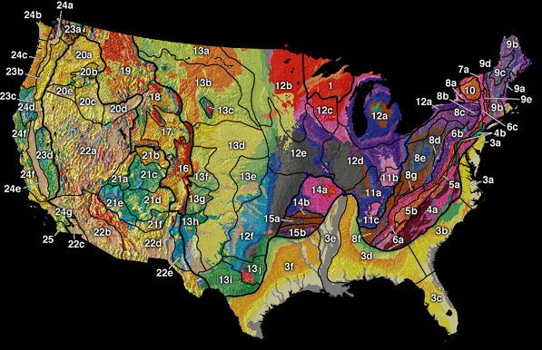
Atlantic Plain
- Atlantic PlainAtlantic PlainThe Atlantic Plain is one of eight distinct United States physiographic regions. This major division consists of the Continental Shelf and Coastal Plain physiographic provinces. It is the flattest of the U.S. physiographic divisions and stretches over in length from Cape Cod to the Mexican border...
2. Continental Shelf
Continental shelf
The continental shelf is the extended perimeter of each continent and associated coastal plain. Much of the shelf was exposed during glacial periods, but is now submerged under relatively shallow seas and gulfs, and was similarly submerged during other interglacial periods. The continental margin,...
(not on map)
3. Coastal Plain
Atlantic Coastal Plain
The Atlantic coastal plain has both low elevation and low relief, but it is also a relatively flat landform extending from the New York Bight southward to a Georgia/Florida section of the Eastern Continental Divide, which demarcates the plain from the ACF River Basin in the Gulf Coastal Plain to...
- 3a. Embayed section
- 3b. Sea Island section
- 3c. FloridianFloridaFlorida is a state in the southeastern United States, located on the nation's Atlantic and Gulf coasts. It is bordered to the west by the Gulf of Mexico, to the north by Alabama and Georgia and to the east by the Atlantic Ocean. With a population of 18,801,310 as measured by the 2010 census, it...
section - 3d. East Gulf Coastal PlainGulf Coastal PlainThe Gulf Coastal Plain extends around the Gulf of Mexico in the Southern United States and eastern Mexico.The plain reaches from the western Florida Panhandle, the southwestern two thirds of Alabama, over most of Mississippi, some of western Tennessee and Kentucky, southwest Arkansas, the Florida...
- 3e. Mississippi Alluvial PlainMississippi Alluvial PlainThe Mississippi River Alluvial Plain is an alluvial plain created by the Mississippi River on which lies parts of seven states, from southern Louisiana to southern Illinois....
- 3f. West Gulf Coastal Plain
Appalachian Highlands
- Appalachian Highlands
4. Piedmont
Piedmont (United States)
The Piedmont is a plateau region located in the eastern United States between the Atlantic Coastal Plain and the main Appalachian Mountains, stretching from New Jersey in the north to central Alabama in the south. The Piedmont province is a physiographic province of the larger Appalachian division...
province
- 4a. Piedmont Upland
- 4b. Piedmont Lowlands
5. Blue Ridge
Blue Ridge Mountains
The Blue Ridge Mountains are a physiographic province of the larger Appalachian Mountains range. This province consists of northern and southern physiographic regions, which divide near the Roanoke River gap. The mountain range is located in the eastern United States, starting at its southern-most...
province
- 5a. Northern section
- 5b. Southern section
6. Valley and Ridge
Ridge-and-valley Appalachians
The Ridge-and-Valley Appalachians, also called the Ridge and Valley Province or the Valley and Ridge Appalachians, are a physiographic province of the larger Appalachian division and are also a belt within the Appalachian Mountains extending from southeastern New York through northwestern New...
province
- 6a. Tennessee section
- 6b. Middle section
- 6c. Hudson ValleyHudson ValleyThe Hudson Valley comprises the valley of the Hudson River and its adjacent communities in New York State, United States, from northern Westchester County northward to the cities of Albany and Troy.-History:...
7. St. Lawrence Valley
- 7a. ChamplainChamplain ValleyThe Champlain Valley is a region of the United States around Lake Champlain in Vermont and New York extending slightly into Quebec, Canada as part of the St. Lawrence River drainage basin drained northward by the Richelieu River into the St...
section - 7b. Northern section (not on map)
8. Appalachian Plateau
Appalachian Plateau
The Appalachian Plateau is the western part of the Appalachian mountains, stretching from New York and Alabama. The plateau is a second level United States physiographic region....
s province
- 8a. MohawkMohawk ValleyThe Mohawk Valley region of the U.S. state of New York is the area surrounding the Mohawk River, sandwiched between the Adirondack Mountains and Catskill Mountains....
section - 8b. CatskillCatskill MountainsThe Catskill Mountains, an area in New York State northwest of New York City and southwest of Albany, are a mature dissected plateau, an uplifted region that was subsequently eroded into sharp relief. They are an eastward continuation, and the highest representation, of the Allegheny Plateau...
section - 8c. Southern New York section
- 8d. Allegheny PlateauAllegheny PlateauThe Allegheny Plateau is a large dissected plateau area in western and central New York, northern and western Pennsylvania, northern and western West Virginia, and eastern Ohio...
section - 8e. Kanawha section
- 8f. Cumberland PlateauCumberland PlateauThe Cumberland Plateau is the southern part of the Appalachian Plateau. It includes much of eastern Kentucky and western West Virginia, part of Tennessee, and a small portion of northern Alabama and northwest Georgia . The terms "Allegheny Plateau" and the "Cumberland Plateau" both refer to the...
section - 8g. Cumberland MountainCumberland MountainsThe Cumberland Mountains are a mountain range in the southeastern section of the Appalachian Mountains. They are located in southern West Virginia, western Virginia, eastern edges of Kentucky, and eastern middle Tennessee, including the Crab Orchard Mountains...
section
9. New England
New England
New England is a region in the northeastern corner of the United States consisting of the six states of Maine, New Hampshire, Vermont, Massachusetts, Rhode Island, and Connecticut...
Province
- 9a. Seaboard Lowland sectionNortheastern coastal forestsThe Northeastern coastal forests are a temperate broadleaf and mixed forests ecoregion of the northeastern United States. The ecoregion covers an area of 34,630 sq miles encompassing the Piedmont and coastal plain of seven states, extending from northern Maryland and Delaware through southeast...
- 9b. New England Upland section
- 9c. White MountainWhite Mountains (New Hampshire)The White Mountains are a mountain range covering about a quarter of the state of New Hampshire and a small portion of western Maine in the United States. Part of the Appalachian Mountains, they are considered the most rugged mountains in New England...
section - 9d. Green MountainGreen MountainsThe Green Mountains are a mountain range in the U.S. state of Vermont. The range extends approximately .-Peaks:The most notable mountains in the range include:*Mount Mansfield, , the highest point in Vermont*Killington Peak, *Mount Ellen,...
section - 9e. TaconicTaconic MountainsThe Taconic Mountains or Taconic Range are a physiographic section of the larger New England province and part of the Appalachian Mountains, running along the eastern border of New York State and adjacent New England from northwest Connecticut to western Massachusetts, north to central western...
section
10. Adirondack
Adirondack Mountains
The Adirondack Mountains are a mountain range located in the northeastern part of New York, that runs through Clinton, Essex, Franklin, Fulton, Hamilton, Herkimer, Lewis, Saint Lawrence, Saratoga, Warren, and Washington counties....
province
Interior Plains
Interior Highlands
Rocky Mountain System
Intermontane Plateaus
- Intermontane PlateausIntermontane PlateausPhysiographic regions of the U.S. InteriorSee:legendIn some places,high plateaus lie between the mountain ranges, for example,the plateau of Anatolia in Turkey and the plateau of Tibet.These are called "Intermontane plateaus"....
20. Columbia Plateau
Columbia River Plateau
The Columbia Plateau is a geologic and geographic region that lies across parts of the U.S. states of Washington, Oregon, and Idaho. It is a wide flood basalt plateau between the Cascade Range and the Rocky Mountains, cut through by the Columbia River...
- 20a. Walla Walla Plateau
- 20b. Blue MountainBlue Mountains (Oregon)The Blue Mountains are a mountain range in the western United States, located largely in northeastern Oregon and stretching into southeastern Washington...
section - 20c. PayettePayette RiverThe Payette River is an river in southwestern Idaho and is a major tributary of the Snake River.Its headwaters originate in the Sawtooth and Salmon River Mountains at elevations over...
section - 20d. Snake River PlainSnake River PlainThe Snake River Plain is a geologic feature located primarily within the state of Idaho in the United States of America. It stretches about westward from northwest of the state of Wyoming to the Idaho-Oregon border. The plain is a wide flat bow-shaped depression, and covers about a quarter of Idaho...
- 20e. Harney sectionHarney sectionThe Harney section is a geomorphological region in eastern Oregon that borders the Great Basin section to the south, the Middle Cascade section to the west and 3 other Columbia Plateau sections on the north, northeast, and east . Said to have been scaled first by Paul Bunyan...
21. Colorado Plateau
Colorado Plateau
The Colorado Plateau, also called the Colorado Plateau Province, is a physiographic region of the Intermontane Plateaus, roughly centered on the Four Corners region of the southwestern United States. The province covers an area of 337,000 km2 within western Colorado, northwestern New Mexico,...
s
- 21a. High Plateaus of Utah
- 21b. Uinta BasinUintah BasinThe Uintah Basin, also spelled Uinta Basin, is a physiographic section of the larger Colorado Plateaus province, which in turn is part of the larger Intermontane Plateaus physiographic division. It is also a geologic structural basin in eastern Utah, east of the Wasatch Mountains and south of the...
- 21c. Canyon LandsCanyon LandsThe Canyon Lands Section of the Colorado Plateaus is a physiographic section of the larger Colorado Plateaus province, which in turn is part of the larger Intermontane Plateaus physiographic division. They are a desolate but spectacularly scenic sandstone area of southeastern Utah...
- 21d. Navajo sectionNavajo sectionThe Navajo Section is a physiographic section of the larger Colorado Plateaus province, which in turn is part of the larger Intermontane Plateaus physiographic division...
- 21e. Grand CanyonGrand CanyonThe Grand Canyon is a steep-sided canyon carved by the Colorado River in the United States in the state of Arizona. It is largely contained within the Grand Canyon National Park, the 15th national park in the United States...
section - 21f. Datil sectionDatil-Mogollon SectionThe Datil-Mogollon Section is a physiographic section of the larger Colorado Plateaus province, which in turn is part of the larger Intermontane Plateaus physiographic division. It is a transitional area between the Basin and Range Province and the Colorado Plateau...
22. Basin and Range
Basin and Range
The Basin and Range Province is a vast physiographic region defined by a unique topographic expression. Basin and Range topography is characterized by abrupt changes in elevation, alternating between narrow faulted mountain chains and flat arid valleys or basins...
province
- 22a. Great Basin sectionGreat Basin sectionThe Great Basin section is a physiographic area which extends into the Colorado River watershed on the southeast , as well as into the watersheds of the Klamath River and Sacramento River...
- 22b. Sonoran DesertSonoran DesertThe Sonoran Desert is a North American desert which straddles part of the United States-Mexico border and covers large parts of the U.S. states of Arizona and California and the northwest Mexican states of Sonora, Baja California, and Baja California Sur. It is one of the largest and hottest...
- 22c. Salton TroughSalton SinkThe Salton Sink is a geographic sink in the Coachella and Imperial valleys of southeastern California. It is in the Colorado Desert subregion of the Sonoran Desert ecoregion...
- 22d. Mexican HighlandMexican PlateauThe Central Mexican Plateau, also known as the Mexican Altiplano or Altiplanicie Mexicana, is a large arid-to-semiarid plateau that occupies much of northern and central Mexico...
- 22e. SacramentoSacramentoSacramento is the capital of the state of California, in the United States of America.Sacramento may also refer to:- United States :*Sacramento County, California*Sacramento, Kentucky*Sacramento – San Joaquin River Delta...
section
Pacific Mountains System
- Pacific Mountain System
region province section Pacific Mountains 23. Cascade-Sierra Mountains Sierra mountainsSierra is a Spanish word meaning "saw". The corresponding word in Portuguese and Latin is serra. This name is used for various mountain ranges in Spanish-speaking and other countries ....23a. Northern Cascade Mountains 23b. Middle Cascade Mountains 23c. Southern Cascade Mountains 23d. Sierra Nevada 24. Pacific Border province Pacific Border provinceThe Pacific Border province is a physiographic province of the Physiographic regions of the world physical geography system.-Description:The Pacific Border province encompasses most of the North American Pacific Coast, with the southern end at the start of the Lower California-Peninsular Ranges...24a. Puget Trough Puget Sound regionThe Puget Sound region is an inland area of the Pacific Northwest in Washington , including Puget Sound, the Puget Sound lowlands, and the surrounding region roughly west of the Cascade Range and east of the Olympic Mountains.- History :...24b. Olympic Mountains Olympic MountainsThe Olympic Mountains is a mountain range on the Olympic Peninsula of western Washington in the United States. The mountains, part of the Pacific Coast Ranges, are not especially high - Mount Olympus is the highest at - but the western slopes of the Olympics rise directly out of the Pacific...24c. Oregon Coast Range Oregon Coast RangeThe Oregon Coast Range, often called simply the Coast Range and sometimes the Pacific Coast Range, is a mountain range, in the Pacific Coast Ranges physiographic region, in the U.S. state of Oregon along the Pacific Ocean...24d. Klamath Mountains Klamath MountainsThe Klamath Mountains, which include the Siskiyou, Marble, Scott, Trinity, Trinity Alps, Salmon, and northern Yolla-Bolly Mountains, are a rugged lightly populated mountain range in northwest California and southwest Oregon in the United States...24e. California Trough 24f. California Coast Ranges 24g. "Los Angeles Ranges—(Transverse Ranges) Transverse RangesThe Transverse Ranges are a group of mountain ranges of southern California, in the Pacific Coast Ranges physiographic region that runs along the Pacific coast from Alaska to Mexico in North America. The Transverse Ranges begin at the southern end of the California Coast Ranges and lie between...
"25. Lower California province—(Peninsular Ranges) Peninsular RangesThe Peninsular Ranges are a group of mountain ranges, in the Pacific Coast Ranges, which stretch from southern California in the United States to the southern tip of Mexico's Baja California peninsula; they are part of the North American Coast Ranges that run along the Pacific coast from Alaska...