

U.S. Route 9 in Delaware
Encyclopedia
In Delaware
, U.S. Route 9 runs an east–west path through the heart of Sussex County
. Even though U.S. Route 9
is signed north–south for the rest of its route, the segment in Delaware is considered east–west. The highway runs from its southern terminus at U.S. Route 13
in Laurel
to the Cape May-Lewes Ferry
in Lewes
, which connects the Delaware segment of U.S. Route 9 to its counterpart in New Jersey
. What is now US 9 in Delaware was originally designated by 1936 as Delaware Route 28 between Laurel and Georgetown and a part of DE 18
between Georgetown and Lewes. US 9 was extended to Delaware from New Jersey by way of the Cape May-Lewes Ferry by 1976, replacing all of DE 28 and the portion of DE 18 between Georgetown and Five Points, with the route aligned to bypass Lewes. DE 404 was designated along the portion of US 9 between Georgetown and Five Points by 1987.
in Hardscrabble
. It the continues to Georgetown
, where just west of the central business district of Georgetown, U.S. Route 9 intersects U.S. Route 113
and becomes Market Street. At this point, a truck bypass of U.S. Route 9 in Georgetown, U.S. Route 9 Truck, loops to the south of Georgetown, returning to U.S. Route 9 east of Georgetown. At the downtown circle in Georgetown, U.S. Route 9 meets Delaware Route 18
and Delaware Route 404, which is part of a major route between the Baltimore-Washington Metropolitan Area
and the Delaware beaches by way of the Chesapeake Bay Bridge
. Delaware Route 404 overlaps U.S. Route 9 for the purpose of providing a one-number route for beach traffic from the Baltimore-Washington Area.
 The concurrent U.S. Route 9 and Delaware Route 404 then continue east on the Lewes Georgetown Highway through rural eastern Sussex County, intersecting Delaware Route 30
in Gravel Hill and Delaware Route 5
in Harbeson
. They continue east to the Five Points intersection in Nassau
. It intersects Delaware Route 23
and Delaware Route 1D and then intersects Delaware Route 1, where Delaware Route 404 ends and U.S. Route 9 Business heads east into Lewes. U.S. Route 9 itself turns south for a concurrency with Delaware Route 1. In Carpenters Corner
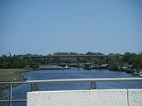
, it turns east onto Dartmouth Drive briefly before making a left and bypassing the heart of Lewes to the south on Kings Highway and the Theodore C. Freeman Highway. The route crosses the Lewes and Rehoboth Canal
on a high-level bridge. At the east end of the Theodore C. Freeman Highway on the Delaware Bay
, U.S. Route 9 re-meets U.S. Route 9 Business. U.S. Route 9 then continues a brief distance on Henlopen Drive before reaching the Cape May-Lewes Ferry terminal, where the ferry carries the route to Cape May, New Jersey
.
By 1976, US 9 was extended across the ferry from New Jersey to Delaware, replacing DE 28 between Laurel and Georgetown and DE 18 between Georgetown and Five Points. Between Five Points and the terminal of the Cape May-Lewes Ferry, US 9 followed DE 14
(now DE 1), Kings Highway, and Theodore C. Freeman Highway before coming to Cape Henlopen Drive. At the same time, US 9 Business was designated onto the former alignment of DE 18 between Five Points and Lewes as well as a portion of Cape Henlopen Drive connecting to US 9. US 9 Truck was created as a truck bypass of the portion of US 9 through Georgetown by 1984. DE 404 was extended to follow US 9 between Georgetown and Five Points by 1987.
.
{| class=wikitable
!Location
!Milepost
!Intersecting road
!Notes
|-
|Laurel
|0.00
|
|
|-
|Hardscrabble
|5.54
|
|
|-
|rowspan=3|Georgetown
|12.05
|
|
|-
|12.79
|
|Traffic circle
, west end of DE 404 overlap
|-
|14.00
|
|
|-
|Gravel Hill
|15.70
|
|
|-
|Harbeson
|18.85
|
|
|-
|rowspan=2|Nassau
|
|
|West end of DE 1D/DE 23 overlap
|-
|25.21
|
|East end of DE 1D/DE 23/DE 404 overlap
West end of DE 1 overlap
|-
|Carpenters Corner
|26.33
|
|East end of DE 1 overlap
|-
|rowspan=2|Lewes
|29.21
|
|
|-
|30.92
|Cape May-Lewes Ferry
– Cape May, NJ
, Garden State Parkway
|
|-
Delaware
Delaware is a U.S. state located on the Atlantic Coast in the Mid-Atlantic region of the United States. It is bordered to the south and west by Maryland, and to the north by Pennsylvania...
, U.S. Route 9 runs an east–west path through the heart of Sussex County
Sussex County, Delaware
Sussex County is a county located in the southern part of the U.S. state of Delaware. As of 2010 the population was 197,145, an increase of 25.9% over the previous decade. The county seat is Georgetown. The Seaford Micropolitan Statistical Area includes all of Sussex County.Sussex County is...
. Even though U.S. Route 9
U.S. Route 9
U.S. Route 9 is a north–south United States highway in the states of Delaware, New Jersey, and New York in the United States. It is one of only two U.S. highways with a ferry connection ; the other being US 10. US 9 is signed east–west in Delaware and north–south on the rest of...
is signed north–south for the rest of its route, the segment in Delaware is considered east–west. The highway runs from its southern terminus at U.S. Route 13
U.S. Route 13
U.S. Route 13 is a north–south U.S. highway established in 1926 that runs for from Interstate 95 just north of Fayetteville, North Carolina to the northeastern suburbs of Philadelphia, Pennsylvania, in Morrisville. In all, it traverses five states in the Atlantic coastal plain region,...
in Laurel
Laurel, Delaware
As of the census of 2000, there were 3,668 people, 1,389 households, and 957 families residing in the town. The population density was 2,215.9 people per square mile . There were 1,561 housing units at an average density of 943.0 per square mile...
to the Cape May-Lewes Ferry
Cape May-Lewes Ferry
The Cape May – Lewes Ferry is a ferry system that traverses a 17-mile crossing of the Delaware Bay to connect Cape May, New Jersey with Lewes, Delaware. The ferry doubles as a section of U.S. Route 9.-The system:...
in Lewes
Lewes, Delaware
Lewes is an incorporated city in Sussex County, Delaware, USA, on the Delmarva Peninsula. According to the 2010 census, the population is 2,747, a decrease of 6.3% from 2000....
, which connects the Delaware segment of U.S. Route 9 to its counterpart in New Jersey
New Jersey
New Jersey is a state in the Northeastern and Middle Atlantic regions of the United States. , its population was 8,791,894. It is bordered on the north and east by the state of New York, on the southeast and south by the Atlantic Ocean, on the west by Pennsylvania and on the southwest by Delaware...
. What is now US 9 in Delaware was originally designated by 1936 as Delaware Route 28 between Laurel and Georgetown and a part of DE 18
Delaware Route 18
Delaware Route 18 is a state highway located in Sussex County, Delaware. It runs from Maryland Route 318 at the Maryland border east of Federalsburg, Maryland to U.S. Route 9 in Georgetown, Delaware...
between Georgetown and Lewes. US 9 was extended to Delaware from New Jersey by way of the Cape May-Lewes Ferry by 1976, replacing all of DE 28 and the portion of DE 18 between Georgetown and Five Points, with the route aligned to bypass Lewes. DE 404 was designated along the portion of US 9 between Georgetown and Five Points by 1987.
Route description
U.S. Route 9 starts out at an intersection with U.S. Route 13 in the northern part of Laurel, heading to the northeast on the County Seat Highway. It passes through rural areas and intersects Delaware Route 20Delaware Route 20
Delaware Route 20 is an east–west highway in Sussex County, Delaware. Its western terminus is the Maryland state line just west of Seaford where it continues as Maryland Route 392. Its eastern terminus is Delaware Route 54 west of Fenwick Island. The route passes through the towns of...
in Hardscrabble
Hardscrabble, Delaware
Hardscrabble is an unincorporated community in Sussex County, Delaware, United States. Hardscrabble is located on Delaware Route 20 between Seaford and Millsboro....
. It the continues to Georgetown
Georgetown, Delaware
Georgetown is a town in Sussex County, Delaware, United States. According to 2010 census figures, the population of the town is 6,422, an increase of 38.3% over the previous decade...
, where just west of the central business district of Georgetown, U.S. Route 9 intersects U.S. Route 113
U.S. Route 113
U.S. Route 113 is a spur of US 13 in the U.S. states of Maryland and Delaware. The U.S. Highway runs from US 13 in Pocomoke City, Maryland north to Delaware Route 1 in Milford, Delaware...
and becomes Market Street. At this point, a truck bypass of U.S. Route 9 in Georgetown, U.S. Route 9 Truck, loops to the south of Georgetown, returning to U.S. Route 9 east of Georgetown. At the downtown circle in Georgetown, U.S. Route 9 meets Delaware Route 18
Delaware Route 18
Delaware Route 18 is a state highway located in Sussex County, Delaware. It runs from Maryland Route 318 at the Maryland border east of Federalsburg, Maryland to U.S. Route 9 in Georgetown, Delaware...
and Delaware Route 404, which is part of a major route between the Baltimore-Washington Metropolitan Area
Baltimore-Washington Metropolitan Area
The Baltimore-Washington Metropolitan Area is a combined statistical area consisting of the overlapping labor market region of the cities of Baltimore, Maryland and Washington, D.C.. The region includes Central Maryland, Northern Virginia, and Jefferson County in the Eastern Panhandle of West...
and the Delaware beaches by way of the Chesapeake Bay Bridge
Chesapeake Bay Bridge
The Chesapeake Bay Bridge is a major dual-span bridge in the U.S. state of Maryland. Spanning the Chesapeake Bay, it connects the state's rural Eastern Shore region with the more urban Western Shore. The original span opened in 1952 and, at the time, with a length of , it was the world's longest...
. Delaware Route 404 overlaps U.S. Route 9 for the purpose of providing a one-number route for beach traffic from the Baltimore-Washington Area.
Delaware Route 30
Delaware Route 30 is a state highway in Sussex County, Delaware. The route runs from an intersection with Bi-State Boulevard a short distance west of U.S. Route 13 between Laurel and Delmar to Delaware Route 1 Business southeast of Milford in the area of Lincoln City and Cedar Creek. The road runs...
in Gravel Hill and Delaware Route 5
Delaware Route 5
Delaware Route 5 is a state highway in Sussex County, Delaware. The route runs north from the Indian River Bay in Oak Orchard north to Delaware Route 1 north of Milton. Along the way, DE 5 passes through Long Neck, Harbeson, and Milton. The route has concurrencies with Delaware Route 23 and...
in Harbeson
Harbeson, Delaware
Harbeson is an unincorporated community in east central Sussex County, Delaware, United States. It lies at the intersection of U.S. Route 9 and Delaware Route 5, east of the town of Georgetown, the county seat of Sussex County. Its elevation is 36 feet...
. They continue east to the Five Points intersection in Nassau
Nassau, Delaware
Nassau is an unincorporated community in eastern Sussex County, Delaware, United States. It lies just off Delaware Route 1 northeast of the town of Georgetown, the county seat of Sussex County. Its elevation is 26 feet...
. It intersects Delaware Route 23
Delaware Route 23
Delaware Route 23 is a state highway in Sussex County, Delaware. Its southern terminus is at Massey's Landing in Long Neck, near the confluence of Rehoboth Bay and Indian River Bay and its northern terminus is at the Five Points intersection, where it ends at Delaware Route 1, U.S. Route 9 and...
and Delaware Route 1D and then intersects Delaware Route 1, where Delaware Route 404 ends and U.S. Route 9 Business heads east into Lewes. U.S. Route 9 itself turns south for a concurrency with Delaware Route 1. In Carpenters Corner
Carpenters Corner, Delaware
Carpenters Corner, Delaware is a village 2 miles south of Lewes, Delaware and 4 miles east of Rehoboth Beach in Sussex County, Delaware, at 38º44'30", 75º09'00".-Reference:...
, it turns east onto Dartmouth Drive briefly before making a left and bypassing the heart of Lewes to the south on Kings Highway and the Theodore C. Freeman Highway. The route crosses the Lewes and Rehoboth Canal
Lewes and Rehoboth Canal
The Lewes and Rehoboth Canal is a canal in Sussex County, Delaware. It connects the Broadkill River to Rehoboth Bay, and forms a portion of the Intracoastal Waterway.-External links:* - Southern terminus - Northern terminus...
on a high-level bridge. At the east end of the Theodore C. Freeman Highway on the Delaware Bay
Delaware Bay
Delaware Bay is a major estuary outlet of the Delaware River on the Northeast seaboard of the United States whose fresh water mixes for many miles with the waters of the Atlantic Ocean. It is in area. The bay is bordered by the State of New Jersey and the State of Delaware...
, U.S. Route 9 re-meets U.S. Route 9 Business. U.S. Route 9 then continues a brief distance on Henlopen Drive before reaching the Cape May-Lewes Ferry terminal, where the ferry carries the route to Cape May, New Jersey
Cape May, New Jersey
Cape May is a city at the southern tip of Cape May Peninsula in Cape May County, New Jersey, where the Delaware Bay meets the Atlantic Ocean and is one of the country's oldest vacation resort destinations. It is part of the Ocean City Metropolitan Statistical Area. As of the 2010 United States...
.
History
What is currently US 9 in Delaware existed as a state highway between Whaleys Corners and Georgetown by 1920, with the remainder as an unimproved county road. At the time, the road was a state aid highway between Laurel and Whaleys Corners and under contract as a state aid highway between Georgetown and Harbeson. By 1924, the state highway along the present alignment of US 9 was completed, running from Laurel through Georgetown to Lewes. By 1925, what is now US 9 along the DE 1 concurrency was built as a state highway. The Kings Highway portion of the current route was paved by 1931. When Delaware assigned numbers to its state highways by 1936, DE 28 was designated to run from US 13 in Laurel to DE 18 in Georgetown while the road between Georgetown and Lewes became a part of DE 18. By 1954, US 13 was moved to a new alignment to the east of Laurel, and the western terminus of DE 28 was truncated to the new location of US 13. The Cape May-Lewes Ferry was started in 1964; at this time, the ferry did not carry a route number.By 1976, US 9 was extended across the ferry from New Jersey to Delaware, replacing DE 28 between Laurel and Georgetown and DE 18 between Georgetown and Five Points. Between Five Points and the terminal of the Cape May-Lewes Ferry, US 9 followed DE 14
Delaware Route 14
Delaware Route 14 is a state highway in the southern part of Kent County, Delaware. The route runs from the Maryland border in Burrsville, where it continues as Maryland Route 317, east to DE 1 in Milford...
(now DE 1), Kings Highway, and Theodore C. Freeman Highway before coming to Cape Henlopen Drive. At the same time, US 9 Business was designated onto the former alignment of DE 18 between Five Points and Lewes as well as a portion of Cape Henlopen Drive connecting to US 9. US 9 Truck was created as a truck bypass of the portion of US 9 through Georgetown by 1984. DE 404 was extended to follow US 9 between Georgetown and Five Points by 1987.
Junction list
The entire route is in Sussex CountySussex County, Delaware
Sussex County is a county located in the southern part of the U.S. state of Delaware. As of 2010 the population was 197,145, an increase of 25.9% over the previous decade. The county seat is Georgetown. The Seaford Micropolitan Statistical Area includes all of Sussex County.Sussex County is...
.
{| class=wikitable
!Location
!Milepost
!Intersecting road
!Notes
|-
|Laurel
Laurel, Delaware
As of the census of 2000, there were 3,668 people, 1,389 households, and 957 families residing in the town. The population density was 2,215.9 people per square mile . There were 1,561 housing units at an average density of 943.0 per square mile...
|0.00
|
|
|-
|Hardscrabble
Hardscrabble, Delaware
Hardscrabble is an unincorporated community in Sussex County, Delaware, United States. Hardscrabble is located on Delaware Route 20 between Seaford and Millsboro....
|5.54
|
|
|-
|rowspan=3|Georgetown
Georgetown, Delaware
Georgetown is a town in Sussex County, Delaware, United States. According to 2010 census figures, the population of the town is 6,422, an increase of 38.3% over the previous decade...
|12.05
|
|
|-
|12.79
|
|Traffic circle
Traffic circle
A traffic circle or rotary is a type of circular intersection in which traffic must travel in one direction around a central island. In some countries, traffic entering the circle has the right-of-way and drivers in the circle must yield. In many other countries, traffic entering the circle must...
, west end of DE 404 overlap
|-
|14.00
|
|
|-
|Gravel Hill
|15.70
|
|
|-
|Harbeson
Harbeson, Delaware
Harbeson is an unincorporated community in east central Sussex County, Delaware, United States. It lies at the intersection of U.S. Route 9 and Delaware Route 5, east of the town of Georgetown, the county seat of Sussex County. Its elevation is 36 feet...
|18.85
|
|
|-
|rowspan=2|Nassau
Nassau, Delaware
Nassau is an unincorporated community in eastern Sussex County, Delaware, United States. It lies just off Delaware Route 1 northeast of the town of Georgetown, the county seat of Sussex County. Its elevation is 26 feet...
|
|
|West end of DE 1D/DE 23 overlap
|-
|25.21
|
|East end of DE 1D/DE 23/DE 404 overlap
West end of DE 1 overlap
|-
|Carpenters Corner
Carpenters Corner, Delaware
Carpenters Corner, Delaware is a village 2 miles south of Lewes, Delaware and 4 miles east of Rehoboth Beach in Sussex County, Delaware, at 38º44'30", 75º09'00".-Reference:...
|26.33
|
|East end of DE 1 overlap
|-
|rowspan=2|Lewes
Lewes, Delaware
Lewes is an incorporated city in Sussex County, Delaware, USA, on the Delmarva Peninsula. According to the 2010 census, the population is 2,747, a decrease of 6.3% from 2000....
|29.21
|
|
|-
|30.92
|Cape May-Lewes Ferry
Cape May-Lewes Ferry
The Cape May – Lewes Ferry is a ferry system that traverses a 17-mile crossing of the Delaware Bay to connect Cape May, New Jersey with Lewes, Delaware. The ferry doubles as a section of U.S. Route 9.-The system:...
– Cape May, NJ
Cape May, New Jersey
Cape May is a city at the southern tip of Cape May Peninsula in Cape May County, New Jersey, where the Delaware Bay meets the Atlantic Ocean and is one of the country's oldest vacation resort destinations. It is part of the Ocean City Metropolitan Statistical Area. As of the 2010 United States...
, Garden State Parkway
Garden State Parkway
The Garden State Parkway is a 172.4-mile limited-access toll parkway that stretches the length of New Jersey from the New York line at Montvale, New Jersey, to Cape May at New Jersey's southernmost tip. Its name refers to New Jersey's nickname, the "Garden State." Most New Jersey residents refer...
|
|-