

U.S. Route 93 in Nevada
Encyclopedia
In the U.S. state
of Nevada
, U.S. Route 93 (US 93) is a major U.S. highway traversing the eastern edge of the state. The highway connects the Las Vegas
area to the Great Basin National Park
, and provides further connections to Ely
and Wells
. US 93 also provides the part of the most direct connection between Las Vegas and Phoenix, Arizona
via Boulder City
, Hoover Dam
and Wickenburg, Arizona
(with a final link to Phoenix via U.S. Route 60
).
border near Eureka, Montana
south through Montana
and Idaho
to a southern terminus at Wells, Nevada
. The establishment of the highway was reflected on Nevada's 1927 official highway map. The Nevada section was approximately 70 miles (112.7 km), commissioned along what was then the northern portion of State Route 13.
AASHO, at its June 8, 1931 meeting, approved a southerly extension of US 93 south to Glendale, Nevada
. By 1932, the Nevada Department of Highways
had marked the continuation of the highway using the routing of several preexisting state highways as follows:
At the request of the Arizona State Highway Department
, the AASHO route numbering committee approved another extension of US 93 in 1935. This shifted the southern terminus south to Kingman
, Arizona
by way of Las Vegas
. However, Nevada officials may not have signed the extension of US 93 right away, since it was not shown on state-published maps until 1939. The highway was again extended along existing highways:
The new routing put the Nevada mileage of U.S. Route 93 at approximately 540 miles (869 km). The entire highway within Nevada was paved by 1939.
The first major shift of US 93 occurred in 1967, when a new highway connection was completed between US 91 and a point 24 miles (38.6 km) northwest of Glendale. The new route was oriented more north–south, shortening the distance between the Las Vegas area and Caliente by 23 miles (37 km) . The old section of US 93 northwest of Glendale paralleling the Muddy River
remained numbered State Route 7. (This section is now State Route 168).
US 93 was realigned in 2010 when the Mike O'Callaghan – Pat Tillman Memorial Bridge was completed. The highway no longer rides over Hoover Dam.
}
|
|-
|
|Airport Road (SR 816) – Lincoln County Airport
|
|-
|
|
|
|
|-
|
|
|
|
|-
|Pioche
|
|, Spring Valley State Park
|
|-
|
|
|
|
|-
|
|
|
|
|-
|rowspan=6|White Pine
0.00–116.69
|
|
|(SR 894) – Shoshone
|
|-
|Major's Place
|27.61
|, Delta
|South end of US 6 & US 50 overlap
|-
|rowspan=2|Ely
|
|
|North end of US 6 overlap
|-
|53.45
|
|North end of US 50 overlap
|-
|
|
|
|
|-
|Lages Station
|
|
|
|-
|rowspan=5|Elko
0.00–127.54
|
|
|
|serves Ruby Lake National Wildlife Refuge
|-
|
|
|
|
|-
|rowspan=2|Wells
|
|, Salt Lake City
|
|-
|
|
|
|-
|Jackpot
|127.54
|colspan=2 align=center|Idaho
state line
|}
U.S. state
A U.S. state is any one of the 50 federated states of the United States of America that share sovereignty with the federal government. Because of this shared sovereignty, an American is a citizen both of the federal entity and of his or her state of domicile. Four states use the official title of...
of Nevada
Nevada
Nevada is a state in the western, mountain west, and southwestern regions of the United States. With an area of and a population of about 2.7 million, it is the 7th-largest and 35th-most populous state. Over two-thirds of Nevada's people live in the Las Vegas metropolitan area, which contains its...
, U.S. Route 93 (US 93) is a major U.S. highway traversing the eastern edge of the state. The highway connects the Las Vegas
Las Vegas, Nevada
Las Vegas is the most populous city in the U.S. state of Nevada and is also the county seat of Clark County, Nevada. Las Vegas is an internationally renowned major resort city for gambling, shopping, and fine dining. The city bills itself as The Entertainment Capital of the World, and is famous...
area to the Great Basin National Park
Great Basin National Park
Great Basin National Park is a United States National Park established in 1986, located in east-central Nevada near the Utah border. The park derives its name from the Great Basin, the dry and mountainous region between the Sierra Nevada and the Wasatch Mountains. Topographically, this area is...
, and provides further connections to Ely
Ely, Nevada
Ely is the largest city and county seat of White Pine County, Nevada, United States. Ely was founded as a stagecoach station along the Pony Express and Central Overland Route. Ely's mining boom came later than the other towns along US 50, with the discovery of copper in 1906...
and Wells
Wells, Nevada
Wells is a city in Elko County, in northeast Nevada in the western United States. The population was 1,346 at the 2000 census. Wells is located at the junction of U.S. Route 93 and Interstate 80, approximately east of Elko and is part of the Elko Micropolitan Statistical Area.-History:The site...
. US 93 also provides the part of the most direct connection between Las Vegas and Phoenix, Arizona
Phoenix, Arizona
Phoenix is the capital, and largest city, of the U.S. state of Arizona, as well as the sixth most populated city in the United States. Phoenix is home to 1,445,632 people according to the official 2010 U.S. Census Bureau data...
via Boulder City
Boulder City, Nevada
Boulder City is a city in Clark County, Nevada, United States. It is approximately from the City of Las Vegas. As of the 2010 census the population of Boulder City was 15,023.Boulder City is one of only two cities in Nevada that prohibit gambling....
, Hoover Dam
Hoover Dam
Hoover Dam, once known as Boulder Dam, is a concrete arch-gravity dam in the Black Canyon of the Colorado River, on the border between the US states of Arizona and Nevada. It was constructed between 1931 and 1936 during the Great Depression and was dedicated on September 30, 1935, by President...
and Wickenburg, Arizona
Wickenburg, Arizona
Wickenburg is a town in Maricopa County, Arizona, United States. According to 2006 Census Bureau estimates, the population of the town is 6,423.-Geography:Wickenburg is located at ....
(with a final link to Phoenix via U.S. Route 60
U.S. Route 60
U.S. Route 60 is an east–west United States highway, running from the Atlantic Ocean on the east coast in Virginia to western Arizona. Despite the final "0" in its number, indicating a transcontinental designation, the 1926 route formerly ended in Springfield, Missouri, at its intersection...
).
Route description
Establishment
U.S. Route 93 was not one of the original U.S. highways proposed in the 1925 Bureau of Public Roads plan. However, the revised numbering plan approved by the American Association of State Highway Officials (AASHO) on November 11, 1926 established US 93 from the CanadianCanada
Canada is a North American country consisting of ten provinces and three territories. Located in the northern part of the continent, it extends from the Atlantic Ocean in the east to the Pacific Ocean in the west, and northward into the Arctic Ocean...
border near Eureka, Montana
Eureka, Montana
Eureka is a town in Lincoln County, Montana, United States. The population was 1,017 at the 2000 census.-Geography:Eureka is located at , approximately from Kalispell....
south through Montana
Montana
Montana is a state in the Western United States. The western third of Montana contains numerous mountain ranges. Smaller, "island ranges" are found in the central third of the state, for a total of 77 named ranges of the Rocky Mountains. This geographical fact is reflected in the state's name,...
and Idaho
Idaho
Idaho is a state in the Rocky Mountain area of the United States. The state's largest city and capital is Boise. Residents are called "Idahoans". Idaho was admitted to the Union on July 3, 1890, as the 43rd state....
to a southern terminus at Wells, Nevada
Wells, Nevada
Wells is a city in Elko County, in northeast Nevada in the western United States. The population was 1,346 at the 2000 census. Wells is located at the junction of U.S. Route 93 and Interstate 80, approximately east of Elko and is part of the Elko Micropolitan Statistical Area.-History:The site...
. The establishment of the highway was reflected on Nevada's 1927 official highway map. The Nevada section was approximately 70 miles (112.7 km), commissioned along what was then the northern portion of State Route 13.
AASHO, at its June 8, 1931 meeting, approved a southerly extension of US 93 south to Glendale, Nevada
Glendale, Nevada
Glendale is an unincorporated community in Clark County, Nevada, United States. The community is an elevation of ....
. By 1932, the Nevada Department of Highways
Nevada Department of Transportation
The Nevada Department of Transportation is a government agency in the U.S. state of Nevada. NDOT is responsible for maintaining and improving Nevada's highway system, which includes U.S. highways and Interstate highways within the state's boundaries. The department is notable for its...
had marked the continuation of the highway using the routing of several preexisting state highways as follows:
- From Wells, US 93 continued southeast along the remainder of SR 13 to its terminus at Lages StationLages Station, NevadaLages Station is a ghost town in White Pine County, in the U.S. state of Nevada....
. - At Lages Station, the highway turned south, overlapping the southern portion of State Route 24 to Magnuson's Ranch.
- At Magnuson's Ranch, US 93 followed State Route 2 south for 31.2 miles (50.2 km) to ElyEly, NevadaEly is the largest city and county seat of White Pine County, Nevada, United States. Ely was founded as a stagecoach station along the Pony Express and Central Overland Route. Ely's mining boom came later than the other towns along US 50, with the discovery of copper in 1906...
. - The highway was then routed concurrently along the entirety of the nearly 250 miles (402.3 km) State Route 7, running southeast from Ely through Connor's Pass, south through PiochePioche, Nevada-External links:*...
to CalienteCaliente, NevadaCaliente , formerly known as Culverwell and Calientes is a town in Lincoln County, Nevada, United States. Its elevation is 4,300 feet . The population was 1,123 at the 2000 census...
, west to Crystal SpringsCrystal Springs, NevadaCrystal Springs is a ghost town in the Pahranagat Valley region of Lincoln County, Nevada. The ghost town is located at the junction of SR 318 and SR 375, also known as the Extraterrestrial Highway. It is a popular destination for passersby who want to visit the towns of Hiko and Rachel...
and then southeast through AlamoAlamo, NevadaAlamo is an unincorporated community in Lincoln County, Nevada, United States, about north of Las Vegas. Its elevation is 3,449 feet . It is named after the Spanish word for "poplar" due to the presence of that type of tree. Founded in 1901, Alamo lies in the Pahranagat Valley. Its economy is...
and Moapa before terminating at U.S. Route 91/State Route 6 in Glendale.
At the request of the Arizona State Highway Department
Arizona Department of Transportation
The Arizona Department of Transportation is an Arizona state government agency charged with facilitating mobility within the state. In addition to managing the state's highway system, the agency is also involved with public transportation and municipal airports...
, the AASHO route numbering committee approved another extension of US 93 in 1935. This shifted the southern terminus south to Kingman
Kingman, Arizona
Kingman is located in a desert climate on the edge of the Mojave Desert, but its higher elevation and location between the Colorado Plateau and the Lower Colorado River Valley tempers summer high temperatures and contributes to winter cold and rare snowfall. Summer daytime highs reach above 90 °F ...
, Arizona
Arizona
Arizona ; is a state located in the southwestern region of the United States. It is also part of the western United States and the mountain west. The capital and largest city is Phoenix...
by way of Las Vegas
Las Vegas, Nevada
Las Vegas is the most populous city in the U.S. state of Nevada and is also the county seat of Clark County, Nevada. Las Vegas is an internationally renowned major resort city for gambling, shopping, and fine dining. The city bills itself as The Entertainment Capital of the World, and is famous...
. However, Nevada officials may not have signed the extension of US 93 right away, since it was not shown on state-published maps until 1939. The highway was again extended along existing highways:
- From Glendale, US 93 followed US 91/SR 6 southwest 50 miles (80.5 km) to Las Vegas.
- In downtown Las Vegas, the route turned southeast and ran concurrent with U.S. Route 466/State Route 5 for 19 miles (30.6 km) southeast to the town of Alunite (near the present-day Railroad Pass).
- At Alunite, US 93 turned to follow US 466/State Route 26 east for 4 miles (6.4 km) into Boulder CityBoulder City, NevadaBoulder City is a city in Clark County, Nevada, United States. It is approximately from the City of Las Vegas. As of the 2010 census the population of Boulder City was 15,023.Boulder City is one of only two cities in Nevada that prohibit gambling....
. - In Boulder City, the route, still concurrent with US 466, dropped SR 26 and gained State Route 42 for the 6 miles (9.7 km) journey towards Boulder Dam into Arizona.
The new routing put the Nevada mileage of U.S. Route 93 at approximately 540 miles (869 km). The entire highway within Nevada was paved by 1939.
Route changes
After US 93 was extended to Arizona in the 1930s, the route remained unchanged for many years. A 19 miles (30.6 km) concurrency with U.S. Route 95 between Las Vegas and Alunite was added in 1940, when that highway was extended through southern Nevada along State Route 5.The first major shift of US 93 occurred in 1967, when a new highway connection was completed between US 91 and a point 24 miles (38.6 km) northwest of Glendale. The new route was oriented more north–south, shortening the distance between the Las Vegas area and Caliente by 23 miles (37 km) . The old section of US 93 northwest of Glendale paralleling the Muddy River
Muddy River
The Muddy River, formerly known as the Moapa River, is a short river located in the southern part of the state in Clark County, Nevada, United States. It is in the Mojave Desert, approximately 60 miles north of Las Vegas.-Geography:...
remained numbered State Route 7. (This section is now State Route 168).
US 93 was realigned in 2010 when the Mike O'Callaghan – Pat Tillman Memorial Bridge was completed. The highway no longer rides over Hoover Dam.
Major intersections
- Note: Mileposts in Nevada reset at county lines; the start and end mileposts for each county are given in the county column.
| County | Location | Mile | Destination | Notes |
|---|---|---|---|---|
| Clark Clark County, Nevada -Demographics:As of the census of 2000, there were 1,375,765 people, 512,253 households, and 339,693 families residing within the MSA. The racial makeup of the MSA was 71.6% White , 9.1% Black, 5.7% Asian, 0.8% American Indian and 12.8% of other or mixed race. 22.0% were Hispanic of any race... 0.00–86.58 |
0.00 | Mike O'Callaghan – Pat Tillman Memorial Bridge over the Colorado River Colorado River The Colorado River , is a river in the Southwestern United States and northwestern Mexico, approximately long, draining a part of the arid regions on the western slope of the Rocky Mountains. The watershed of the Colorado River covers in parts of seven U.S. states and two Mexican states... — Arizona Arizona Arizona ; is a state located in the southwestern region of the United States. It is also part of the western United States and the mountain west. The capital and largest city is Phoenix... state line |
||
| – Hoover Dam Hoover Dam Hoover Dam, once known as Boulder Dam, is a concrete arch-gravity dam in the Black Canyon of the Colorado River, on the border between the US states of Arizona and Nevada. It was constructed between 1931 and 1936 during the Great Depression and was dedicated on September 30, 1935, by President... |
Old US 93 | |||
| Boulder City Boulder City, Nevada Boulder City is a city in Clark County, Nevada, United States. It is approximately from the City of Las Vegas. As of the 2010 census the population of Boulder City was 15,023.Boulder City is one of only two cities in Nevada that prohibit gambling.... |
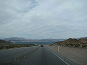
Lakeshore Drive – Lake Mead Lake Mead Lake Mead is the largest reservoir in the United States. It is located on the Colorado River about southeast of Las Vegas, Nevada, in the states of Nevada and Arizona. Formed by water impounded by the Hoover Dam, it extends behind the dam, holding approximately of water.-History:The lake was... |
Former SR 166 | ||
| 11.29 | , Needles Needles, California Needles is a city located in the Mojave Desert on the western banks of the Colorado River in San Bernardino County, California. It is located in the Mohave Valley, which straddles the California–Arizona border. The city is accessible via Interstate 40 and U.S. Route 95... |
South end of US 95 overlap | ||
| Henderson Henderson, Nevada -Demographics:According to the 2000 census, there were 175,381 people, 66,331 households, and 47,095 families residing in the city. The population density was 2,200.8 people per square mile . There were 71,149 housing units at an average density of 892.8 per square mile... Las Vegas Las Vegas, Nevada Las Vegas is the most populous city in the U.S. state of Nevada and is also the county seat of Clark County, Nevada. Las Vegas is an internationally renowned major resort city for gambling, shopping, and fine dining. The city bills itself as The Entertainment Capital of the World, and is famous... North Las Vegas North Las Vegas, Nevada North Las Vegas is a city in Clark County, Nevada, United States, located in the Las Vegas metropolitan area. The city was incorporated on May 16, 1946.-Geography:... |
See I-515 | |||
| See I-15 | ||||
| 52.03 | , Salt Lake City Salt Lake City, Utah Salt Lake City is the capital and the most populous city of the U.S. state of Utah. The name of the city is often shortened to Salt Lake or SLC. With a population of 186,440 as of the 2010 Census, the city lies in the Salt Lake City metropolitan area, which has a total population of 1,124,197... |
North end of I-15 overlap | ||
| Lincoln Lincoln County, Nevada Lincoln County is a county located in the U.S. state of Nevada. As of the 2000 census, the population was 4,165. Its county seat is Pioche.-History:... 0.00–172.87 |
||||
| Caliente Caliente, Nevada Caliente , formerly known as Culverwell and Calientes is a town in Lincoln County, Nevada, United States. Its elevation is 4,300 feet . The population was 1,123 at the 2000 census... |
||||
| Panaca Panaca, Nevada Panaca is a town in eastern Lincoln County, Nevada, on State Route 319, about 1 mile east of U.S. Route 93, near the border with Utah. Its elevation is 4,729 feet .-History:... |
||||
|
|-
|
|Airport Road (SR 816) – Lincoln County Airport
Lincoln County Airport
Lincoln County Airport is a county-owned public-use airport located two miles west of the central business district of Panaca, a town in Lincoln County, Nevada, United States.- Facilities and aircraft :...
|
|-
|
|
|
|
|-
|
|
|
|
|-
|Pioche
Pioche, Nevada
-External links:*...
|
|, Spring Valley State Park
Spring Valley State Park
Spring Valley State Park is a state park of Nevada, USA, adjoining the Eagle Valley Reservoir. It is located near the eastern border with the state of Utah, east of the town of Pioche and near the village of Ursine.-History:...
|
|-
|
|
|
|
|-
|
|
|
|
|-
|rowspan=6|White Pine
White Pine County, Nevada
White Pine County is a county located in the U.S. state of Nevada. Its population at the 2010 census was 10,030. Its county seat is Ely. It is the home of Great Basin National Park...
0.00–116.69
|
|
|(SR 894) – Shoshone
|
|-
|Major's Place
|27.61
|, Delta
Delta, Utah
Delta is a city in Millard County, Utah, United States. The population was 3,209 at the 2000 census.-Geography:Delta is located at ....
|South end of US 6 & US 50 overlap
|-
|rowspan=2|Ely
Ely, Nevada
Ely is the largest city and county seat of White Pine County, Nevada, United States. Ely was founded as a stagecoach station along the Pony Express and Central Overland Route. Ely's mining boom came later than the other towns along US 50, with the discovery of copper in 1906...
|
|
|North end of US 6 overlap
|-
|53.45
|
|North end of US 50 overlap
|-
|
|
|
|
|-
|Lages Station
Lages Station, Nevada
Lages Station is a ghost town in White Pine County, in the U.S. state of Nevada....
|
|
|
|-
|rowspan=5|Elko
Elko County, Nevada
-Demographics:As of the census of 2000, there were 45,291 people, 15,638 households, and 11,493 families residing in the county. The population density was 3/sq mi . There were 18,456 housing units at an average density of 1/sq mi...
0.00–127.54
|
|
|
|serves Ruby Lake National Wildlife Refuge
Ruby Lake National Wildlife Refuge
The Ruby Lake National Wildlife Refuge is located in southwestern Elko County and northwestern White Pine County in the northeastern section of the state of Nevada in the western United States. Established in 1938, it encompasses 37,632 acres of wetlands in Ruby Valley, just east of the Ruby...
|-
|
|
|
|
|-
|rowspan=2|Wells
Wells, Nevada
Wells is a city in Elko County, in northeast Nevada in the western United States. The population was 1,346 at the 2000 census. Wells is located at the junction of U.S. Route 93 and Interstate 80, approximately east of Elko and is part of the Elko Micropolitan Statistical Area.-History:The site...
|
|, Salt Lake City
Salt Lake City, Utah
Salt Lake City is the capital and the most populous city of the U.S. state of Utah. The name of the city is often shortened to Salt Lake or SLC. With a population of 186,440 as of the 2010 Census, the city lies in the Salt Lake City metropolitan area, which has a total population of 1,124,197...
|
|-
|
|
|
|-
|Jackpot
Jackpot, Nevada
Jackpot is an unincorporated community in Elko County, Nevada, United States. The Zip Code Tabulation Area for its ZIP code, 89825, had a population of 1,189 as of the 2010 census. Located less than 1 mile from the Idaho border on U.S...
|127.54
|colspan=2 align=center|Idaho
Idaho
Idaho is a state in the Rocky Mountain area of the United States. The state's largest city and capital is Boise. Residents are called "Idahoans". Idaho was admitted to the Union on July 3, 1890, as the 43rd state....
state line
|}