

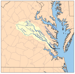
Pamunkey River
Encyclopedia
Tributary
A tributary or affluent is a stream or river that flows into a main stem river or a lake. A tributary does not flow directly into a sea or ocean...
of the York River
York River (Virginia)
The York River is a navigable estuary, approximately long, in eastern Virginia in the United States. It ranges in width from at its head to near its mouth on the west side of Chesapeake Bay. Its watershed drains an area including portions of 17 counties of the coastal plain of Virginia north...
, about 93 miles (149.7 km) long, in eastern Virginia
Virginia
The Commonwealth of Virginia , is a U.S. state on the Atlantic Coast of the Southern United States. Virginia is nicknamed the "Old Dominion" and sometimes the "Mother of Presidents" after the eight U.S. presidents born there...
in the United States
United States
The United States of America is a federal constitutional republic comprising fifty states and a federal district...
. Via the York River it is part of the watershed
Drainage basin
A drainage basin is an extent or an area of land where surface water from rain and melting snow or ice converges to a single point, usually the exit of the basin, where the waters join another waterbody, such as a river, lake, reservoir, estuary, wetland, sea, or ocean...
of Chesapeake Bay
Chesapeake Bay
The Chesapeake Bay is the largest estuary in the United States. It lies off the Atlantic Ocean, surrounded by Maryland and Virginia. The Chesapeake Bay's drainage basin covers in the District of Columbia and parts of six states: New York, Pennsylvania, Delaware, Maryland, Virginia, and West...
.
Course
The Pamunkey River is formed by the confluence of the North AnnaNorth Anna River
The North Anna River is a principal tributary of the Pamunkey River, about long, in central Virginia in the United States. Via the Pamunkey and York rivers, it is part of the watershed of Chesapeake Bay...
and South Anna
South Anna River
The South Anna River is a principal tributary of the Pamunkey River, about long, in central Virginia in the United States. Via the Pamunkey and York rivers, it is part of the watershed of Chesapeake Bay....
rivers on the boundary of Hanover
Hanover County, Virginia
As of the census of 2000, there were 86,320 people, 31,121 households, and 24,461 families residing in the county. The population density was 183 people per square mile . There were 32,196 housing units at an average density of 68 per square mile...
and Caroline
Caroline County, Virginia
Caroline County is a county located in the Commonwealth of Virginia. As of 2010, the population was 28,545. Its county seat is Bowling Green. Caroline County is also home to The Meadow stables, the birthplace of the renowned racehorse Secretariat, winner of the 1973 Kentucky Derby, Preakness and...
counties, about 5 miles (8 km) northeast of the town of Ashland
Ashland, Virginia
Originally known as Slash Cottage, Ashland is located on the Old Washington Highway U.S. Route One and the Richmond, Fredericksburg and Potomac Railroad, a busy north-south route now owned by CSX Transportation...
. It flows generally southeastwardly past the Pamunkey Indian Reservation
Pamunkey Indian Reservation
Pamunkey Indian Reservation is a Native American Reservation located in Virginia in the United States. The reservation lies along the Pamunkey River in King William County, Virginia on the Middle Peninsula. The Pamunkey Reservation contains approximately 1,200 acres of land, 500 acres of which is...
to the town of West Point
West Point, Virginia
West Point is an incorporated town in King William County, Virginia, United States. The population was 2,867 at the 2000 census.-Geography:West Point is located at...
, where it meets the Mattaponi River
Mattaponi River
The Mattaponi River is a tributary of the York River estuary in eastern Virginia in the United States.It rises as four streams in Spotsylvania County, each of which is given a shorter piece of the Mattaponi's name:...
to form the York River. The river's course is used to define all or portions of the southern boundaries of Caroline and King William
King William County, Virginia
As of the census of 2000, there were 13,146 people, 4,846 households, and 3,784 families residing in the county. The population density was 48 people per square mile . There were 5,189 housing units at an average density of 19 per square mile...
counties and the northern boundaries of Hanover and New Kent
New Kent County, Virginia
At the 2000 census, there were 13,462 people, 4,925 households and 3,895 families residing in the county. The population density was 64 per square mile . There were 5,203 housing units at an average density of 25 per square mile...
counties.
Variant names
The U.S. Board on Geographic Names settled on "Pamunkey River" as the river's official name in 1892. According to the Geographic Names Information SystemGeographic Names Information System
The Geographic Names Information System is a database that contains name and locative information about more than two million physical and cultural features located throughout the United States of America and its territories. It is a type of gazetteer...
it has also been known as:
- Pamauncke River
- Pamoeoncock River
- Pamunky River
- Pemaeoncock
- Yough-ta-mund
- Youghtanund