

U.S. Route 192
Encyclopedia
U.S. Route 192 is an east–west route of the United States Numbered Highway system in central Florida
. It runs 75.04 miles (120.76 km) from U.S. Route 27 (State Road 25
) in Citrus Ridge
, Lake County
, east past Walt Disney World and through Kissimmee
, St. Cloud
and Melbourne
, to end at State Road A1A
in Indialantic
, one block from the Atlantic Ocean
. It crosses (and runs concurrent with) its "parent", U.S. Route 92, in Kissimmee.
The U.S. Route is assigned the following unsigned State Road numbers:
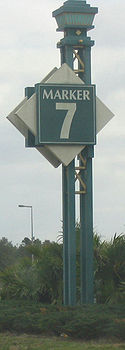
US 192 is a major tourist strip in the area around the Walt Disney World Resort
, including "mile markers" (with a variable distance between each) to help tourists locate businesses. In the late 1990s, the Osceola Parkway
(County Road 522) opened, providing a tolled
alternate between Walt Disney World and Kissimmee.
For most of its route, US 192 is the Irlo Bronson Memorial Highway, named after former state representative, senator and cattleman Irlo O. Bronson, Sr.. It is also known as Space Coast Parkway, as it leads to the Space Coast
.
.svg.png)
 US 192 (SR 530) begins at a trumpet interchange on U.S. Route 27 (State Road 25
) in Lake County
, just north of the Polk County
line. (Three of the four ramps enter Polk County.) It heads east as a four-to-six lane divided highway
, crossing into Orange County (just north of Osceola County
) after about a mile (1.5 km). Soon after entering Orange County, County Road 545 heads north, serving the far western areas of the county. An old alignment of US 192 (Bali Boulevard) is present to the north between the county line and CR 545; it used to continue east to the south (in Osceola County) to near Lindfields Boulevard.
After spending under two miles (3 km) in Orange County, US 192 crosses the line into Osceola County
, continuing to parallel it. It intersects with State Road 429 (opened to the north in late 2005 and to the south in late 2006) before curving southeast away from the county line. In that area, the density of tourist attraction
s increases as the road approaches Walt Disney World. An old alignment (Black Lake Road) is present on the north side between the curve away from the county line and Sherberth Road, near where it curves back east. Sherberth Road is the westernmost public access to Disney World, intersecting the Osceola Parkway
west of Disney's Animal Kingdom
. Just east of it is an intersection with County Road 545, which heads south.
Near the crossing of Reedy Creek
, US 192 enters the Reedy Creek Improvement District
(Walt Disney World). Both sides of the road are owned by Disney and kept empty, so US 192 has a short freeway section through Disney World. An interchange
provides access to World Drive, the main north–south road in Disney World, and then US 192 crosses Interstate 4 (State Road 400), the end of Disney property. The north side again is filled with tourist attraction
s, while the south side is at first part of Celebration, Disney's planned community
.
Celebration Avenue heads south to an interchange
with State Road 417
, which crosses US 192 with no direct access. Just east of that crossing, US 192 crosses Bonnet Creek, the east end of Celebration, and International Drive
heads north. An intersection with Poinciana Boulevard provides access to the Osceola Parkway
to the north and Poinciana
to the south, and State Road 535
heads north soon after. SR 535, and US 192 to the east, is part of the old Kissimmee
-Vineland
Road, built parallel to the Florida Midland Railroad
; the intersection of US 192 and SR 535 has been moved to give US 192 the through road.
Just after crossing SR 535, US 192 turns southeast onto the alignment of the old Kissimmee-Vineland Road. Another old alignment - Old Vineland Road - is present in this section, rejoining as US 192 turns back east towards downtown Kissimmee
. After the road crosses Shingle Creek
, it becomes Kissimmee's Vine Street, a major east–west road passing north of downtown. Close to downtown, US 192 crosses John Young Parkway
. This is a major north–south road from Kissimmee north to Orlando, built as an alternate to the Orange Blossom Trail. To the south, since ca. 2000, John Young Parkway carries U.S. Route 17/92 (State Road 600) southwest out of Kissimmee. US 17, US 92 and SR 600 run concurrent with US 192 and SR 530 for 3/4 mile (1.2 km) to Main Street, which heads south into downtown Kissimmee and north to Orlando as the Orange Blossom Trail. This carries US 17, US 92 and SR 600 to the north, and carried them south until ca. 2000. Also to the north on Main Street is U.S. Route 441 (State Road 500
); both of these routes turn east with US 192 out of Kissimmee. SR 530 ends at the intersection of Vine Street and Main Street; thus Vine Street carries US 192, US 441 and SR 500 east from Kissimmee.
Several miles from downtown Kissimmee, US 192 turns southeast; straight ahead is the former beginning of Boggy Creek Road (now realigned to intersect US 192 to the east). Soon after is an interchange
with Florida's Turnpike
(State Road 91). This interchange, consisting of a connector road between US 192 and a trumpet interchange at the Turnpike, once served all movements. A new northbound offramp was built several miles to the east, where US 192 crosses the Turnpike, when the Turnpike north of SR 60 changed from a ticket system
to a coin system.
After crossing the Turnpike, US 192 turns back east, becoming 13th Street in St. Cloud
. The original alignment (part of the Kissimmee-Melbourne Highway) between Kissimmee and St. Cloud, which paralleled the St. Cloud and Sugar Belt Railway, began at Main Street and Drury Avenue in downtown Kissimmee, heading east on Drury Avenue and Neptune Road, crossing US 192 west of downtown St. Cloud and becoming 10th Street. In St. Cloud, County Road 523 heads south at Vermont Avenue. After leaving St. Cloud, at the unincorporated community of Ashton, County Road 15 (Narcoossee Road) heads north past Narcoossee
and into Orange County
. Unsigned State Road 15 begins at that intersection, heading east with US 192, US 441 and SR 500. 10th Street (the old alignment) ends at CR 15 north of US 192, but the road used to continue across, turning southeast to hit US 192 east of CR 15.
 Leaving the St. Cloud area, US 192 again begins to turn southeast, running mainly through swampland
for the rest of its path to Melbourne. Another old alignment - Lake Lizzie Drive - begins there, running north of US 192 to its end just west of Alligator Creek. County Road 532 (Nova Road) splits off to the northeast in that area, crossing Lake Lizzle Drive and then turning east. After the Alligator Creek crossing, yet another old alignment - Old Melbourne Highway, former State Road 500A - splits to the east. Portions of this road have been closed to the public, as the old road runs past Mercury Marine
's former Lake X
landing strip. The rest of the alignment is on private property owned mostly by Deseret Ranch
.
At Holopaw
, around the middle of the old alignment, U.S. Route 441 and State Road 15 split off to the south, leaving only US 192 and SR 500 beyond to Melbourne. West of Deer Park
, the old road crosses to the south side of the new road. Several miles later, at Deer Park, County Road 419 begins to the north; the road to the south is unnumbered and ends at old US 192. From there, the old alignment heads straight east back to the current road, passing the Kempfer Sawmill and the former Union Cypress Railroad.
Soon after the old and new alignments join, US 192 crosses into Brevard County
on the original Kissimmee-Melbourne Highway, roughly paralleling the old Union Cypress Railroad. As it approaches Melbourne
on New Haven Avenue, it crosses Interstate 95
(State Road 9
), intersects County Road 511 (north only), crosses County Road 509, and intersects State Road 507
. Soon after SR 507, US 192 cuts northeast to Strawbridge Avenue, which runs one block north of New Haven Avenue, providing a bypass of the Historic Downtown Melbourne. After crossing U.S. Route 1 (State Road 5
) at the site of the historic 1900 Building
, Strawbridge Avenue and New Haven Avenue merge at the west end of the Melbourne Causeway
across the Indian River
. New Haven Avenue is still maintained by the state east of US 1, and is considered a section of SR 500. East of the Indian River, US 192 enters Indialantic
on Fifth Avenue, where it spends four blocks before ending at State Road A1A
, one short block from the Atlantic Ocean
.
to State Road 4 in Melbourne
. This road had been built in 1918 through the land of George W. Hopkins
. In the mid-1920s, SR 24 became part of the Dixie Highway
, connecting the western route in Kissimmee with the eastern route in Melbourne.
The United States Numbered Highways
were assigned in late 1926, including U.S. Route 192, running from U.S. Route 92 in Kissimmee east to U.S. Route 1 in Melbourne. In the 1930s, several sections in Osceola County
were realigned.
In 1931, another State Road - State Road 257 - was defined. This route would begin in Kissimmee, heading northwest on the Kissimmee-Vineland
Road and west on the Kissimmee-Lake Wilson Road, and then make its way generally north to Clermont
and Howey-in-the-Hills
. (This follows the existing US 192 from Kissimmee to the curve just west of Walt Disney World; the road was never built beyond the west end of Oak Island Road.)
SR 24 was extended east in 1933 to State Road 140 (now State Road A1A
) at the Atlantic Ocean
, but US 192 did not join it. In 1935, SR 24 was extended the other way, from Kissimmee northwest along the Kissimmee-Vineland Road and beyond, ending in Mount Plymouth
. (This overlapped with the beginning of SR 257, and only coincided with present US 192 there.)
In the 1945 renumbering, three State Roads were assigned to what is now US 192. From Kissimmee to Melbourne, still the only part of US 192 at the time, SR 24 became part of State Road 500
. The 1933 extension of SR 24 to the Atlantic Ocean became the short State Road 516. Finally, State Road 530 was assigned along former SR 24 and SR 257 from Kissimmee west to the end of Oak Island Road, turning south there along Goodman Road and Old Lake Wilson Road to Loughman
, continuing east on Loughman Road to end at State Road 600 (U.S. Highway 17/92).
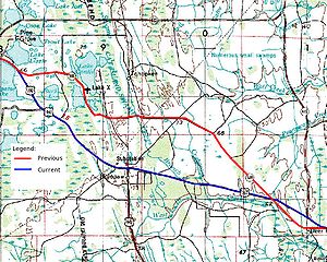
On July 13, 1950, a newly-constructed road, running west from the south end of State Road 545 to U.S. Route 27 (State Road 25
), was assigned the number State Road 545A. This soon became part of SR 530, which was rerouted to its present alignment.
In the late 1960s, US 192 was extended east along SR 516 (renumbered at some point to an extension of SR 500) to end at State Road A1A
In 1972 it was extended west along SR 530 to U.S. Route 27 (State Road 25
), crossing Interstate 4 and the recently-opened Walt Disney World Resort
along the way.
US 192 underwent extensive reconstruction in the 1990s, which continues to the present date. The widening of the portion from SR 535 to Interstate 4 to six lanes went several years behind schedule because of unanticipated drainage complications. Construction to widen US 192 to four lanes from east of St. Cloud to I-95, eliminating the remaining 2-lane section, was completed in 2008. The rebuilt intersection with I-4 was fully opened in July 2007.
In 2010, the 15-traffic lights in the 5 miles between I-95 and Babcock Street in the Melbourne area, resulted in congestion, sometimes bringing traffic to a standstill near the Melbourne Square Mall connected to traffic management and controlled by computer or manually be an operator.
Central Florida
Central Florida is a regional designation for the area surrounding Orlando in east central Florida, United States. The area represents the third largest population concentration in Florida, after the South Florida and Tampa Bay regions, respectively....
. It runs 75.04 miles (120.76 km) from U.S. Route 27 (State Road 25
State Road 25 (Florida)
State Road 25 is a state highway in the U.S. state of Florida.It is mainly signed as U.S. Highways:*U.S. Highway 27 from Miami to Lady Lake and Belleview to Ocala*U.S. Highway 301 from Belleview to near Sparr...
) in Citrus Ridge
Citrus Ridge, Florida
Citrus Ridge, often called Four Corners, is a census-designated place in the U.S. state of Florida, located at a quadripoint formed by Lake, Orange, Osceola and Polk Counties. U.S. Routes 27 and 192 serve the area. The population was 12,015 at the 2000 census...
, Lake County
Lake County, Florida
Lake County is a county located in the state of Florida, United States. As of the 2000 Census, the population was 210,528. The Census Bureau estimated the population in 2008 to be 307,243. Its county seat is Tavares...
, east past Walt Disney World and through Kissimmee
Kissimmee, Florida
Kissimmee is a city in Osceola County, Florida, United States. As of the 2010 census, the population was 59,682. It is the county seat of Osceola County...
, St. Cloud
St. Cloud, Florida
St. Cloud is a city in Osceola County, Florida, United States. The population was 35,183 at the 2010 census. St. Cloud is closely associated with the adjacent city of Kissimmee and its proximity to Orlando area theme parks, including Walt Disney World, Universal Orlando Resort, and Seaworld.St...
and Melbourne
Melbourne, Florida
Melbourne is a city in Brevard County, Florida, United States. As of 2009, the population estimated by the U.S. Census Bureau is 78,323. The municipal area is the second largest by size and by population in the county. Melbourne is a principal city of the Palm Bay – Melbourne – Titusville, Florida...
, to end at State Road A1A
State Road A1A (Florida)
State Road A1A is a Florida State Road that runs mostly along the Atlantic Ocean, with sections from Key West at the southern tip of Florida, to Callahan, just south of Georgia. It is the main road through most oceanfront towns. SR A1A is designated the A1A Scenic and Historic Coastal Highway, a...
in Indialantic
Indialantic, Florida
Indialantic is a town in Brevard County, Florida, United States. The name is a portmanteau derived from the town's location between the Indian River Lagoon and the Atlantic Ocean....
, one block from the Atlantic Ocean
Atlantic Ocean
The Atlantic Ocean is the second-largest of the world's oceanic divisions. With a total area of about , it covers approximately 20% of the Earth's surface and about 26% of its water surface area...
. It crosses (and runs concurrent with) its "parent", U.S. Route 92, in Kissimmee.
The U.S. Route is assigned the following unsigned State Road numbers:
- The full length of State Road 530, 18.41 miles (29.63 km) from US 27 (SR 25) to Main Street in Kissimmee
- The southernmost part of State Road 500State Road 500 (Florida)State Road 500 is a major state highway running through Florida as a mostly unsigned route under several US Highways. From Chiefland to Williston it is U.S. Highway 27 Alternate. From Williston to Ocala, it is U.S. Highway 27. From Ocala to Kissimmee, it is U.S. Highway 441. From Kissimmee to...
, 56.62 miles (91.12 km) from Kissimmee to Indialantic
US 192 is a major tourist strip in the area around the Walt Disney World Resort
Walt Disney World Resort
Walt Disney World Resort , is the world's most-visited entertaimental resort. Located in Lake Buena Vista, Florida ; approximately southwest of Orlando, Florida, United States, the resort covers an area of and includes four theme parks, two water parks, 23 on-site themed resort hotels Walt...
, including "mile markers" (with a variable distance between each) to help tourists locate businesses. In the late 1990s, the Osceola Parkway
Osceola Parkway
The Osceola Parkway, signed as County Road 522 since around 2003 , is a long, partially-tolled arterial road extending east-west across the northern boundary of Osceola County, Florida, USA roughly paralleling the border with Orange County...
(County Road 522) opened, providing a tolled
Toll road
A toll road is a privately or publicly built road for which a driver pays a toll for use. Structures for which tolls are charged include toll bridges and toll tunnels. Non-toll roads are financed using other sources of revenue, most typically fuel tax or general tax funds...
alternate between Walt Disney World and Kissimmee.
For most of its route, US 192 is the Irlo Bronson Memorial Highway, named after former state representative, senator and cattleman Irlo O. Bronson, Sr.. It is also known as Space Coast Parkway, as it leads to the Space Coast
Space Coast
The Space Coast is a region in the U.S. state of Florida around Kennedy Space Center , where NASA launched space shuttles until the last one on July 8th, 2011 at 11:29am; and Cape Canaveral Air Force Station, site of unmanned civilian and military space launches...
.
Route description
State Road 25 (Florida)
State Road 25 is a state highway in the U.S. state of Florida.It is mainly signed as U.S. Highways:*U.S. Highway 27 from Miami to Lady Lake and Belleview to Ocala*U.S. Highway 301 from Belleview to near Sparr...
) in Lake County
Lake County, Florida
Lake County is a county located in the state of Florida, United States. As of the 2000 Census, the population was 210,528. The Census Bureau estimated the population in 2008 to be 307,243. Its county seat is Tavares...
, just north of the Polk County
Polk County, Florida
Polk County is located in central Florida between the Tampa Bay and Greater Orlando metropolitan areas. The county was established by the state government in 1861 on the eve of the American Civil War and named after former United States president James K. Polk. The county seat is Bartow and its...
line. (Three of the four ramps enter Polk County.) It heads east as a four-to-six lane divided highway
Divided Highway
Divided Highway is a compilation album by American rock band The Doobie Brothers, released in 2003. . All tracks are taken from the albums Cycles and Brotherhood .-Track listing:...
, crossing into Orange County (just north of Osceola County
Osceola County, Florida
Osceola County is a county located in the U.S. state of Florida. As of 2000, the population was 172,493. The U.S. Census Bureau 2006 estimate for the county is 244,045, making it the 17th fastest-growing county in the United States. Its county seat is Kissimmee.- History :Osceola County was...
) after about a mile (1.5 km). Soon after entering Orange County, County Road 545 heads north, serving the far western areas of the county. An old alignment of US 192 (Bali Boulevard) is present to the north between the county line and CR 545; it used to continue east to the south (in Osceola County) to near Lindfields Boulevard.
After spending under two miles (3 km) in Orange County, US 192 crosses the line into Osceola County
Osceola County, Florida
Osceola County is a county located in the U.S. state of Florida. As of 2000, the population was 172,493. The U.S. Census Bureau 2006 estimate for the county is 244,045, making it the 17th fastest-growing county in the United States. Its county seat is Kissimmee.- History :Osceola County was...
, continuing to parallel it. It intersects with State Road 429 (opened to the north in late 2005 and to the south in late 2006) before curving southeast away from the county line. In that area, the density of tourist attraction
Tourist attraction
A tourist attraction is a place of interest where tourists visit, typically for its inherent or exhibited cultural value, historical significance, natural or built beauty, or amusement opportunities....
s increases as the road approaches Walt Disney World. An old alignment (Black Lake Road) is present on the north side between the curve away from the county line and Sherberth Road, near where it curves back east. Sherberth Road is the westernmost public access to Disney World, intersecting the Osceola Parkway
Osceola Parkway
The Osceola Parkway, signed as County Road 522 since around 2003 , is a long, partially-tolled arterial road extending east-west across the northern boundary of Osceola County, Florida, USA roughly paralleling the border with Orange County...
west of Disney's Animal Kingdom
Disney's Animal Kingdom
Disney's Animal Kingdom is an animal theme park located at the Walt Disney World Resort. The fourth park built at the resort, it opened on April 22, 1998, and it is the largest single Disney theme park in the world, covering more than . It is also the first Disney theme park to be themed entirely...
. Just east of it is an intersection with County Road 545, which heads south.
Near the crossing of Reedy Creek
Reedy Creek
Reedy Creek may refer to places in:Australia* Reedy Creek, Queensland** Reedy Creek Observatory, observatory* Reedy Creek Reserve, QueenslandUSA* Reedy Creek Improvement District, Florida* Reedy Creek...
, US 192 enters the Reedy Creek Improvement District
Reedy Creek Improvement District
The Reedy Creek Improvement District is the immediate governing jurisdiction for the land of the Walt Disney World Resort. As of the late 1990s, it comprised an area of within the outer limits of Orange and Osceola counties in Florida...
(Walt Disney World). Both sides of the road are owned by Disney and kept empty, so US 192 has a short freeway section through Disney World. An interchange
Interchange (road)
In the field of road transport, an interchange is a road junction that typically uses grade separation, and one or more ramps, to permit traffic on at least one highway to pass through the junction without directly crossing any other traffic stream. It differs from a standard intersection, at which...
provides access to World Drive, the main north–south road in Disney World, and then US 192 crosses Interstate 4 (State Road 400), the end of Disney property. The north side again is filled with tourist attraction
Tourist attraction
A tourist attraction is a place of interest where tourists visit, typically for its inherent or exhibited cultural value, historical significance, natural or built beauty, or amusement opportunities....
s, while the south side is at first part of Celebration, Disney's planned community
Planned community
A planned community, or planned city, is any community that was carefully planned from its inception and is typically constructed in a previously undeveloped area. This contrasts with settlements that evolve in a more ad hoc fashion. Land use conflicts are less frequent in planned communities since...
.
Celebration Avenue heads south to an interchange
Interchange (road)
In the field of road transport, an interchange is a road junction that typically uses grade separation, and one or more ramps, to permit traffic on at least one highway to pass through the junction without directly crossing any other traffic stream. It differs from a standard intersection, at which...
with State Road 417
State Road 417 (Florida)
State Road 417 , also known as the Central Florida GreeneWay, Southern Connector and Seminole Expressway , is a tolled freeway forming the eastern beltway around the city of Orlando, Florida, United States. It is owned and maintained by the Orlando-Orange County Expressway Authority and Florida's...
, which crosses US 192 with no direct access. Just east of that crossing, US 192 crosses Bonnet Creek, the east end of Celebration, and International Drive
International Drive
International Drive is the main tourist strip of Orlando, Florida, located several miles southwest of proper Downtown Orlando in the southernmost limits of the city...
heads north. An intersection with Poinciana Boulevard provides access to the Osceola Parkway
Osceola Parkway
The Osceola Parkway, signed as County Road 522 since around 2003 , is a long, partially-tolled arterial road extending east-west across the northern boundary of Osceola County, Florida, USA roughly paralleling the border with Orange County...
to the north and Poinciana
Poinciana, Florida
Poinciana is a census-designated place in Osceola and Polk counties in the U.S. state of Florida. It lies southwest of Kissimmee and about east of Haines City...
to the south, and State Road 535
Florida State Road 535
Florida State Road 535, also known as Kissimmee-Vineland Road, is a state road in the U.S. state of Florida. The road begins at U.S. Highway 192 in Kissimmee, Florida, heading north, ending in Lake Buena Vista, Florida, formerly Vineland, Florida...
heads north soon after. SR 535, and US 192 to the east, is part of the old Kissimmee
Kissimmee, Florida
Kissimmee is a city in Osceola County, Florida, United States. As of the 2010 census, the population was 59,682. It is the county seat of Osceola County...
-Vineland
Vineland, Florida
Vineland is an unincorporated community in southwest Orange County, Florida, United States. It is just north of Interstate 4 along State Road 535. The name is not used much any more, since the City of Lake Buena Vista lies just to the south and west and is a more well-known name. Orange County...
Road, built parallel to the Florida Midland Railroad
Florida Midland Railroad (defunct)
The Florida Midland Railway Company was incorporated under the general incorporation laws of Florida, and surveyed a line* from Lake Jessup, in Orange county, to Leesburg, in Sumter County....
; the intersection of US 192 and SR 535 has been moved to give US 192 the through road.
Just after crossing SR 535, US 192 turns southeast onto the alignment of the old Kissimmee-Vineland Road. Another old alignment - Old Vineland Road - is present in this section, rejoining as US 192 turns back east towards downtown Kissimmee
Kissimmee, Florida
Kissimmee is a city in Osceola County, Florida, United States. As of the 2010 census, the population was 59,682. It is the county seat of Osceola County...
. After the road crosses Shingle Creek
Shingle Creek
Shingle Creek may refer to:United States*Shingle Creek , a stream in Central Florida*Shingle Creek, Minneapolis, Minnesota, a neighborhoodCanada*Shingle Creek , a stream in the Okanagan Valley...
, it becomes Kissimmee's Vine Street, a major east–west road passing north of downtown. Close to downtown, US 192 crosses John Young Parkway
John Young Parkway
State Road 423, known for most of its length as John Young Parkway, and Lee Road east of Orange Blossom Trail, is a four- and six-lane surface road in the U.S. state of Florida. SR 423 is completely inside Orlando, Florida and runs from SR 408 north to U.S...
. This is a major north–south road from Kissimmee north to Orlando, built as an alternate to the Orange Blossom Trail. To the south, since ca. 2000, John Young Parkway carries U.S. Route 17/92 (State Road 600) southwest out of Kissimmee. US 17, US 92 and SR 600 run concurrent with US 192 and SR 530 for 3/4 mile (1.2 km) to Main Street, which heads south into downtown Kissimmee and north to Orlando as the Orange Blossom Trail. This carries US 17, US 92 and SR 600 to the north, and carried them south until ca. 2000. Also to the north on Main Street is U.S. Route 441 (State Road 500
State Road 500 (Florida)
State Road 500 is a major state highway running through Florida as a mostly unsigned route under several US Highways. From Chiefland to Williston it is U.S. Highway 27 Alternate. From Williston to Ocala, it is U.S. Highway 27. From Ocala to Kissimmee, it is U.S. Highway 441. From Kissimmee to...
); both of these routes turn east with US 192 out of Kissimmee. SR 530 ends at the intersection of Vine Street and Main Street; thus Vine Street carries US 192, US 441 and SR 500 east from Kissimmee.
Several miles from downtown Kissimmee, US 192 turns southeast; straight ahead is the former beginning of Boggy Creek Road (now realigned to intersect US 192 to the east). Soon after is an interchange
Interchange (road)
In the field of road transport, an interchange is a road junction that typically uses grade separation, and one or more ramps, to permit traffic on at least one highway to pass through the junction without directly crossing any other traffic stream. It differs from a standard intersection, at which...
with Florida's Turnpike
Florida's Turnpike
Florida's Turnpike , designated as the Ronald Reagan Turnpike, and originally known as the Sunshine State Parkway is a north–south toll road that runs through 11 counties in the Florida peninsula, from U.S...
(State Road 91). This interchange, consisting of a connector road between US 192 and a trumpet interchange at the Turnpike, once served all movements. A new northbound offramp was built several miles to the east, where US 192 crosses the Turnpike, when the Turnpike north of SR 60 changed from a ticket system
Ticket system
A ticket system toll road A ticket system toll road A ticket system toll road (also known as closed toll collection system, as opposed to a flat-rate toll road, is utilized by some state toll road or highway agencies that allows a motorist to pay a toll rate based on the number of miles traveled...
to a coin system.
After crossing the Turnpike, US 192 turns back east, becoming 13th Street in St. Cloud
St. Cloud, Florida
St. Cloud is a city in Osceola County, Florida, United States. The population was 35,183 at the 2010 census. St. Cloud is closely associated with the adjacent city of Kissimmee and its proximity to Orlando area theme parks, including Walt Disney World, Universal Orlando Resort, and Seaworld.St...
. The original alignment (part of the Kissimmee-Melbourne Highway) between Kissimmee and St. Cloud, which paralleled the St. Cloud and Sugar Belt Railway, began at Main Street and Drury Avenue in downtown Kissimmee, heading east on Drury Avenue and Neptune Road, crossing US 192 west of downtown St. Cloud and becoming 10th Street. In St. Cloud, County Road 523 heads south at Vermont Avenue. After leaving St. Cloud, at the unincorporated community of Ashton, County Road 15 (Narcoossee Road) heads north past Narcoossee
Narcoossee, Florida
Narcoossee is a small unincorporated community in eastern Osceola County, Florida, United States. It is located on the east side of East Lake Tohopekaliga. The only major road which runs through Narcoossee is State Road 15, commonly referred to as Narcoossee Road, which connects to U.S. Route 192...
and into Orange County
Orange County, Florida
Orange County is a county located in the U.S. state of Florida and is part of the Orlando-Kissimmee-Sanford Metropolitan Statistical Area . As of 2010 U.S. Census, the county had a population of 1,145,956....
. Unsigned State Road 15 begins at that intersection, heading east with US 192, US 441 and SR 500. 10th Street (the old alignment) ends at CR 15 north of US 192, but the road used to continue across, turning southeast to hit US 192 east of CR 15.
Swampland
In physics, the term swampland is used in contrast to the term "landscape," to indicate physical theories or aspects of such theories which could be true if gravity wasn't an issue, but which are not compatible with string theory...
for the rest of its path to Melbourne. Another old alignment - Lake Lizzie Drive - begins there, running north of US 192 to its end just west of Alligator Creek. County Road 532 (Nova Road) splits off to the northeast in that area, crossing Lake Lizzle Drive and then turning east. After the Alligator Creek crossing, yet another old alignment - Old Melbourne Highway, former State Road 500A - splits to the east. Portions of this road have been closed to the public, as the old road runs past Mercury Marine
Mercury Marine
Mercury Marine, founded in 1939, is a division of Brunswick of Lake Forest, Illinois, in the United States. Mercury provides engines for private, commercial and government sales. Mercury also has its own line of very successful racing engines tailored for power and speed. The company's primary...
's former Lake X
Lake Conlin
Lake Conlin is a lake in Osceola County, Florida, United States just north of Old U.S. Route 192 near Holopaw. It is the source of the Econlockhatchee River, Cat Island Swamp, and the Econlockhatchee River Swamp. These bodies of water flow northward to the St. Johns River, downstream. The source...
landing strip. The rest of the alignment is on private property owned mostly by Deseret Ranch
Deseret Ranch
Deseret Ranches refers to the ranching operations of The Church of Jesus Christ of Latter-day Saints in Central Florida. The Ranches include several organizations including Deseret Ranches of Florida, Deseret Cattle and Citrus, Taylor Creek Management, East Central Florida Services, Agreserves, and...
.
At Holopaw
Holopaw, Florida
Holopaw, Florida is a small unincorporated community in Osceola County, Florida, United States. It is located at the eastern end of the multiplex of highways US 192 and US 441. It has a population of fewer than 5,000 people and is part of the Orlando–Kissimmee Metropolitan Statistical...
, around the middle of the old alignment, U.S. Route 441 and State Road 15 split off to the south, leaving only US 192 and SR 500 beyond to Melbourne. West of Deer Park
Deer Park, Florida
Deer Park is an unincorporated community in Osceola County, Florida, United States. It is located off US 192, south of the intersection with County Road 419. The community is part of the Orlando–Kissimmee Metropolitan Statistical Area.-References:...
, the old road crosses to the south side of the new road. Several miles later, at Deer Park, County Road 419 begins to the north; the road to the south is unnumbered and ends at old US 192. From there, the old alignment heads straight east back to the current road, passing the Kempfer Sawmill and the former Union Cypress Railroad.
Soon after the old and new alignments join, US 192 crosses into Brevard County
Brevard County, Florida
Brevard County is a county located in the U.S. state of Florida, along the coast of the Atlantic Ocean. As of 2007 U.S. Census Bureau estimates, the population is 536,521, making it the 10th most populous county in the state. Influenced by the presence of the John F. Kennedy Space Center, Brevard...
on the original Kissimmee-Melbourne Highway, roughly paralleling the old Union Cypress Railroad. As it approaches Melbourne
Melbourne, Florida
Melbourne is a city in Brevard County, Florida, United States. As of 2009, the population estimated by the U.S. Census Bureau is 78,323. The municipal area is the second largest by size and by population in the county. Melbourne is a principal city of the Palm Bay – Melbourne – Titusville, Florida...
on New Haven Avenue, it crosses Interstate 95
Interstate 95 in Florida
Interstate 95 is the main Interstate Highway on the east coast of the United States; it serves the Atlantic coast of Florida. It begins at a partial interchange with U.S. Highway 1 just south of downtown Miami, and heads north past Daytona Beach and Jacksonville to the Georgia state line at the St...
(State Road 9
State Road 9 (Florida)
State Road 9 is a state road in the U.S. state of Florida. While SR 9 is mainly used as a "hidden" state designation for Interstate 95 from the Georgia border to the Golden Glades Interchange in Miami Gardens, a 13.7-mile-long signed SR 9 extends to the southwest as I-95 continues southward with...
), intersects County Road 511 (north only), crosses County Road 509, and intersects State Road 507
State Road 507 (Florida)
Also known locally as Babcock Street, State Road 507 is a -long, four lane highway serving Melbourne and Palm Bay, Florida. The southern terminus is an intersection with Malabar Road in Palm Bay; the current northern terminus is an intersection with New Haven Avenue in Melbourne...
. Soon after SR 507, US 192 cuts northeast to Strawbridge Avenue, which runs one block north of New Haven Avenue, providing a bypass of the Historic Downtown Melbourne. After crossing U.S. Route 1 (State Road 5
State Road 5 (Florida)
State Road 5 is a mostly-unsigned state highway in the state of Florida. It is mainly signed as U.S. Route 1 from its south end in Key West, Florida to Jacksonville, Florida, and U.S. Route 17 from Jacksonville to the Georgia state line at the Saint Marys River. U.S...
) at the site of the historic 1900 Building
1900 Building
The 1900 Building is a historic U.S. building located at 1900 South Harbor City Boulevard, Melbourne, Florida. This two story building was constructed in 1924 and originally opened as the Melbourne Hotel. The building housed several businesses through the years, including a bank, specialty stores...
, Strawbridge Avenue and New Haven Avenue merge at the west end of the Melbourne Causeway
Melbourne Causeway
The Melbourne Causeway is located entirely within Brevard County, Florida in the United States. It is composed of three bridges and connects the municipalities of Melbourne, Florida and Indialantic, Florida across the Indian River Lagoon in Brevard County. The causeway is part of U.S...
across the Indian River
Indian River Lagoon
The Indian River Lagoon is a grouping of three lagoons: Mosquito Lagoon, Banana River, and the Indian River, on the Atlantic Coast of Florida. It was originally named Rio de Ais after the Ais Indian tribe, who lived along the east coast of Florida....
. New Haven Avenue is still maintained by the state east of US 1, and is considered a section of SR 500. East of the Indian River, US 192 enters Indialantic
Indialantic, Florida
Indialantic is a town in Brevard County, Florida, United States. The name is a portmanteau derived from the town's location between the Indian River Lagoon and the Atlantic Ocean....
on Fifth Avenue, where it spends four blocks before ending at State Road A1A
State Road A1A (Florida)
State Road A1A is a Florida State Road that runs mostly along the Atlantic Ocean, with sections from Key West at the southern tip of Florida, to Callahan, just south of Georgia. It is the main road through most oceanfront towns. SR A1A is designated the A1A Scenic and Historic Coastal Highway, a...
, one short block from the Atlantic Ocean
Atlantic Ocean
The Atlantic Ocean is the second-largest of the world's oceanic divisions. With a total area of about , it covers approximately 20% of the Earth's surface and about 26% of its water surface area...
.
History
Florida's State Road system was defined by law in 1923. Included in that system was State Road 24, running along the existing Kissimmee-Melbourne Highway from State Road 2 in KissimmeeKissimmee, Florida
Kissimmee is a city in Osceola County, Florida, United States. As of the 2010 census, the population was 59,682. It is the county seat of Osceola County...
to State Road 4 in Melbourne
Melbourne, Florida
Melbourne is a city in Brevard County, Florida, United States. As of 2009, the population estimated by the U.S. Census Bureau is 78,323. The municipal area is the second largest by size and by population in the county. Melbourne is a principal city of the Palm Bay – Melbourne – Titusville, Florida...
. This road had been built in 1918 through the land of George W. Hopkins
George W. Hopkins
George W. Hopkins was a lumberman involved in the removal of tens of thousands of acres of virgin forests in Michigan and Florida.Hopkins was born in 1844 in Virginia. His father soon moved his family to Michigan in search of farm land. Hopkins became a surveyor and map maker at a young age, and...
. In the mid-1920s, SR 24 became part of the Dixie Highway
Dixie Highway
The Dixie Highway was a United States automobile highway, first planned in 1914 to connect the US Midwest with the Southern United States. It was part of the National Auto Trail system, and grew out of an earlier Miami to Montreal highway. The final result is better understood as a small network of...
, connecting the western route in Kissimmee with the eastern route in Melbourne.
The United States Numbered Highways
United States Numbered Highways
The system of United States Numbered Highways is an integrated system of roads and highways in the United States numbered within a nationwide grid...
were assigned in late 1926, including U.S. Route 192, running from U.S. Route 92 in Kissimmee east to U.S. Route 1 in Melbourne. In the 1930s, several sections in Osceola County
Osceola County, Florida
Osceola County is a county located in the U.S. state of Florida. As of 2000, the population was 172,493. The U.S. Census Bureau 2006 estimate for the county is 244,045, making it the 17th fastest-growing county in the United States. Its county seat is Kissimmee.- History :Osceola County was...
were realigned.
In 1931, another State Road - State Road 257 - was defined. This route would begin in Kissimmee, heading northwest on the Kissimmee-Vineland
Vineland, Florida
Vineland is an unincorporated community in southwest Orange County, Florida, United States. It is just north of Interstate 4 along State Road 535. The name is not used much any more, since the City of Lake Buena Vista lies just to the south and west and is a more well-known name. Orange County...
Road and west on the Kissimmee-Lake Wilson Road, and then make its way generally north to Clermont
Clermont, Florida
Clermont is a city in Lake County, Florida, United States, west of Orlando. The population was 13,100 in 2008. The city is essentially residential in character and its economy is centered in retail trade, lodging, and food and beverage establishments, which are tourism oriented. The historic...
and Howey-in-the-Hills
Howey-in-the-Hills, Florida
Howey-in-the-Hills is a town in Lake County, Florida, United States. The population was 956 at the 2000 census. The Census Bureau estimated the population in 2008 to be 1,248. It is part of the Orlando–Kissimmee Metropolitan Statistical Area.-History:...
. (This follows the existing US 192 from Kissimmee to the curve just west of Walt Disney World; the road was never built beyond the west end of Oak Island Road.)
SR 24 was extended east in 1933 to State Road 140 (now State Road A1A
State Road A1A (Florida)
State Road A1A is a Florida State Road that runs mostly along the Atlantic Ocean, with sections from Key West at the southern tip of Florida, to Callahan, just south of Georgia. It is the main road through most oceanfront towns. SR A1A is designated the A1A Scenic and Historic Coastal Highway, a...
) at the Atlantic Ocean
Atlantic Ocean
The Atlantic Ocean is the second-largest of the world's oceanic divisions. With a total area of about , it covers approximately 20% of the Earth's surface and about 26% of its water surface area...
, but US 192 did not join it. In 1935, SR 24 was extended the other way, from Kissimmee northwest along the Kissimmee-Vineland Road and beyond, ending in Mount Plymouth
Mount Plymouth, Florida
Mount Plymouth is a census-designated place in Lake County, Florida, United States. As of the 2000 census, the CDP population was 2,814. It is part of the Orlando–Kissimmee Metropolitan Statistical Area.-Geography:...
. (This overlapped with the beginning of SR 257, and only coincided with present US 192 there.)
In the 1945 renumbering, three State Roads were assigned to what is now US 192. From Kissimmee to Melbourne, still the only part of US 192 at the time, SR 24 became part of State Road 500
State Road 500 (Florida)
State Road 500 is a major state highway running through Florida as a mostly unsigned route under several US Highways. From Chiefland to Williston it is U.S. Highway 27 Alternate. From Williston to Ocala, it is U.S. Highway 27. From Ocala to Kissimmee, it is U.S. Highway 441. From Kissimmee to...
. The 1933 extension of SR 24 to the Atlantic Ocean became the short State Road 516. Finally, State Road 530 was assigned along former SR 24 and SR 257 from Kissimmee west to the end of Oak Island Road, turning south there along Goodman Road and Old Lake Wilson Road to Loughman
Loughman, Florida
Loughman is a census-designated place in the north-east corner of Polk County, Florida, United States, near the Osceola county line. The population was 1,385 at the 2000 census. It is part of the Lakeland–Winter Haven Metropolitan Statistical Area...
, continuing east on Loughman Road to end at State Road 600 (U.S. Highway 17/92).
On July 13, 1950, a newly-constructed road, running west from the south end of State Road 545 to U.S. Route 27 (State Road 25
State Road 25 (Florida)
State Road 25 is a state highway in the U.S. state of Florida.It is mainly signed as U.S. Highways:*U.S. Highway 27 from Miami to Lady Lake and Belleview to Ocala*U.S. Highway 301 from Belleview to near Sparr...
), was assigned the number State Road 545A. This soon became part of SR 530, which was rerouted to its present alignment.
In the late 1960s, US 192 was extended east along SR 516 (renumbered at some point to an extension of SR 500) to end at State Road A1A
State Road A1A (Florida)
State Road A1A is a Florida State Road that runs mostly along the Atlantic Ocean, with sections from Key West at the southern tip of Florida, to Callahan, just south of Georgia. It is the main road through most oceanfront towns. SR A1A is designated the A1A Scenic and Historic Coastal Highway, a...
In 1972 it was extended west along SR 530 to U.S. Route 27 (State Road 25
State Road 25 (Florida)
State Road 25 is a state highway in the U.S. state of Florida.It is mainly signed as U.S. Highways:*U.S. Highway 27 from Miami to Lady Lake and Belleview to Ocala*U.S. Highway 301 from Belleview to near Sparr...
), crossing Interstate 4 and the recently-opened Walt Disney World Resort
Walt Disney World Resort
Walt Disney World Resort , is the world's most-visited entertaimental resort. Located in Lake Buena Vista, Florida ; approximately southwest of Orlando, Florida, United States, the resort covers an area of and includes four theme parks, two water parks, 23 on-site themed resort hotels Walt...
along the way.
US 192 underwent extensive reconstruction in the 1990s, which continues to the present date. The widening of the portion from SR 535 to Interstate 4 to six lanes went several years behind schedule because of unanticipated drainage complications. Construction to widen US 192 to four lanes from east of St. Cloud to I-95, eliminating the remaining 2-lane section, was completed in 2008. The rebuilt intersection with I-4 was fully opened in July 2007.
In 2010, the 15-traffic lights in the 5 miles between I-95 and Babcock Street in the Melbourne area, resulted in congestion, sometimes bringing traffic to a standstill near the Melbourne Square Mall connected to traffic management and controlled by computer or manually be an operator.