
.gif)
Typhoon Nida (2004)
Encyclopedia
Super Typhoon Nida was the fourth tropical cyclone and second named storm of the 2004 Pacific typhoon season
. Nida was the second super typhoon of the 2004 season, reaching a peak intensity of 160 miles per hour (257.5 km/h). Forming southeast of the Philippines, the storm strengthened as it moved northwest. The typhoon brushed the eastern Philippines
causing heavy rains across the island archipelago. Nida later accelerated northeast, missing Japan
to the east while becoming an extratropical cyclone
. A total of $1.3 million dollars (2004 USD) in damage occurred, and Nida left 31 fatalities.
s formed within a monsoon trough
220 miles (354.1 km) southwest of Palau
. Satellite imagery revealed a weak low-level circulation. Initially, the Joint Typhoon Warning Center
(JTWC) forecast the storm to not strengthen. The following day, forecasters saw that the storm was strengthening and upgraded the system to tropical depression status. Forecasters at the Philippine Atmospheric, Geophysical and Astronomical Services Administration
designated the storm as Tropical Depression Dindo.
At the time of formation, the depression was located 190 miles (305.8 km) east of Palau
as it moved west northwest at 3 mph (5 km/h). Quickscat satellite imagery showed the depression's winds were near 29 mph (46 km/h) and increasing. Satellite imagery later the showed deep convection organizing over the low-level circulation. The depression underwent rapid intensification as it became a tropical storm late in the morning on May 14 and was assigned the name Nida by the Japan Meteorological Agency
(JMA). Still intensifying, the storm turned northwest where it reached typhoon status later that night.
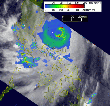
Curving west-northwest at 7 mph (11 km/h), Typhoon Nida attained winds of 115 mph (185 km/h), equivalent to a Category 3 hurricane. On May 16, Nida became a super typhoon as its winds reached 165 mph (266 km/h). At its peak, its highest winds extended 35 miles (56 km) from the center. Satellite imagery showed the storm developed a defined eye measuring 25 miles (40 km) wide. On May 17, the center of Nida passed over Catanduanes Island
, Philippines
.
After making landfall, Nida weakened and then turned more northward and slowed down. Re-entering the warmer waters of the Western Pacific Ocean
, Nida's winds restrengthened to 150 mph (250 km/h). During the night of May 18, the typhoon began to weaken. Infrared
satellite imagery showed the eye
being obscured by high cirrostratus clouds, indicative of the weakening typhoon. The eyewall became significantly disorganized as Nida continued to recurve to the northeast.
Nida accelerated northeast and its maximum sustained wind
s weakened to 90 mph (148 km/h). Interacting with an upper level low pressure system over Japan, the typhoon became elongated. Nida weakened below typhoon strength as the center passed 290 miles (467 km) south of Tokyo, Japan. By May 21, Nida transitioned to an extratropical cyclone
. The JMA continued to track the remnants of Nida as it weakened northeast of northern Japan
.
, evacuation centers were opened to accommodate 2,986 people. The typhoon approach cancelled ferry
operations stranding 15,057 passengers. In Taiwan
, forecasters at the Central Weather Bureau
issued a typhoon warning as forecast models
predicted a high probability of the typhoon hitting Taiwan
. The warnings interrupted the preparations for the inauguration of President Chen Shui-bian
.
 In the Philippines, winds were clocked at 100 knots (196 km/h) at Virac. on Catanduanes Island at 6 a.m. local time on May 17. The pressure at that location fell to 965 mb. Structural damage was severe as the typhoon damaged or destroyed over 700-4,000 homes displacing 11,000 people. In Guimba, Nueva Ecija
, Nida spawned a tornado
that caused moderate damage. After the storm, President Gloria Macapagal Arroyo placed eight providences under a state of emergency
.
Nida produced heavy rainfall across the eastern Philippines
. Rainfall up to 10.6 inches (270 mm) was reported in Ombao while Naga City
received 5.9 inches (150 mm) of rain. The rest of the Philippines
received 104 millimetres (4.1 in) to 372 millimetres (14.6 in) of rain. 31 fatalities (20 confirmed, 11 unaccounted for) were reported during Nida's landfall. In Camotes island, nine people drowned and five were declared missing when a ferry
boat sank during the storm. Elsewhere offshore, 13 crewmen were rescued when their ship ran aground near Luzon
. In all, the typhoon left $1.3 million dollars in damage across the eastern Philippines
.
In Japan, heavy rains produced by the outer bands of Nida triggered flash flooding and landslides in Fukushima Prefecture
. Several highways were shut down due to rising waters or debris and a few homes also were inundated. In Mito, Ibaraki
, 360 homes were left without power after high winds knocked down electrical wires. A 10 m (32.8 ft) section of highway in the city also collapsed. In addition to the structural damage caused by Nida, the poor weather conditions created during its passage resulted in several canceled flights by Japan Air Commuter
. In Minamidaitō, Okinawa
, a weather station operated by the WMO reported winds gusting to 71 mph (115 km/h) and a barometric pressure of 972 mb. Rainfall total at the station was 1.25 inches (32 mm) with the highest at 2.79 inches (71 mm). There were no reports of damage.
The name Nida was not retired by the World Meteorological Organization
during its winter meeting in 2004/2005. As a result the name is currently on the naming list for Pacific typhoons.
2004 Pacific typhoon season
The 2004 Pacific typhoon season has no official bounds; it ran year-round in 2004, but most tropical cyclones tend to form in the northwestern Pacific Ocean between May and November...
. Nida was the second super typhoon of the 2004 season, reaching a peak intensity of 160 miles per hour (257.5 km/h). Forming southeast of the Philippines, the storm strengthened as it moved northwest. The typhoon brushed the eastern Philippines
Philippines
The Philippines , officially known as the Republic of the Philippines , is a country in Southeast Asia in the western Pacific Ocean. To its north across the Luzon Strait lies Taiwan. West across the South China Sea sits Vietnam...
causing heavy rains across the island archipelago. Nida later accelerated northeast, missing Japan
Japan
Japan is an island nation in East Asia. Located in the Pacific Ocean, it lies to the east of the Sea of Japan, China, North Korea, South Korea and Russia, stretching from the Sea of Okhotsk in the north to the East China Sea and Taiwan in the south...
to the east while becoming an extratropical cyclone
Extratropical cyclone
Extratropical cyclones, sometimes called mid-latitude cyclones or wave cyclones, are a group of cyclones defined as synoptic scale low pressure weather systems that occur in the middle latitudes of the Earth having neither tropical nor polar characteristics, and are connected with fronts and...
. A total of $1.3 million dollars (2004 USD) in damage occurred, and Nida left 31 fatalities.
Meteorological history
On May 12, a persistent area of thunderstormThunderstorm
A thunderstorm, also known as an electrical storm, a lightning storm, thundershower or simply a storm is a form of weather characterized by the presence of lightning and its acoustic effect on the Earth's atmosphere known as thunder. The meteorologically assigned cloud type associated with the...
s formed within a monsoon trough
Monsoon trough
The monsoon trough is that portion of the Intertropical Convergence Zone which extends into or through a monsoon circulation, as depicted by a line on a weather map showing the locations of minimum sea level pressure, and as such, is a convergence zone between the wind patterns of the southern and...
220 miles (354.1 km) southwest of Palau
Palau
Palau , officially the Republic of Palau , is an island nation in the Pacific Ocean, east of the Philippines and south of Tokyo. In 1978, after three decades as being part of the United Nations trusteeship, Palau chose independence instead of becoming part of the Federated States of Micronesia, a...
. Satellite imagery revealed a weak low-level circulation. Initially, the Joint Typhoon Warning Center
Joint Typhoon Warning Center
The Joint Typhoon Warning Center is a joint United States Navy – United States Air Force task force located at the Naval Maritime Forecast Center in Pearl Harbor, Hawaii...
(JTWC) forecast the storm to not strengthen. The following day, forecasters saw that the storm was strengthening and upgraded the system to tropical depression status. Forecasters at the Philippine Atmospheric, Geophysical and Astronomical Services Administration
Philippine Atmospheric, Geophysical and Astronomical Services Administration
The Philippine Atmospheric, Geophysical and Astronomical Services Administration is a Philippine national institution dedicated to provide flood and typhoon warnings, public weather forecasts and advisories, meteorological, astronomical, climatological, and other specialized information and...
designated the storm as Tropical Depression Dindo.
At the time of formation, the depression was located 190 miles (305.8 km) east of Palau
Palau
Palau , officially the Republic of Palau , is an island nation in the Pacific Ocean, east of the Philippines and south of Tokyo. In 1978, after three decades as being part of the United Nations trusteeship, Palau chose independence instead of becoming part of the Federated States of Micronesia, a...
as it moved west northwest at 3 mph (5 km/h). Quickscat satellite imagery showed the depression's winds were near 29 mph (46 km/h) and increasing. Satellite imagery later the showed deep convection organizing over the low-level circulation. The depression underwent rapid intensification as it became a tropical storm late in the morning on May 14 and was assigned the name Nida by the Japan Meteorological Agency
Japan Meteorological Agency
The or JMA, is the Japanese government's weather service. Charged with gathering and reporting weather data and forecasts in Japan, it is a semi-autonomous part of the Ministry of Land, Infrastructure and Transport...
(JMA). Still intensifying, the storm turned northwest where it reached typhoon status later that night.
Curving west-northwest at 7 mph (11 km/h), Typhoon Nida attained winds of 115 mph (185 km/h), equivalent to a Category 3 hurricane. On May 16, Nida became a super typhoon as its winds reached 165 mph (266 km/h). At its peak, its highest winds extended 35 miles (56 km) from the center. Satellite imagery showed the storm developed a defined eye measuring 25 miles (40 km) wide. On May 17, the center of Nida passed over Catanduanes Island
Catanduanes Island
Catanduanes Island is the main island of Catanduanes Province. It lies east of the Bicol Peninsula. The island is bounded by the Maqueda Channel in the west, the Pacific Ocean on the north and east, and Lagonoy Gulf and Cabugao Bay on the south....
, Philippines
Philippines
The Philippines , officially known as the Republic of the Philippines , is a country in Southeast Asia in the western Pacific Ocean. To its north across the Luzon Strait lies Taiwan. West across the South China Sea sits Vietnam...
.
After making landfall, Nida weakened and then turned more northward and slowed down. Re-entering the warmer waters of the Western Pacific Ocean
Pacific Ocean
The Pacific Ocean is the largest of the Earth's oceanic divisions. It extends from the Arctic in the north to the Southern Ocean in the south, bounded by Asia and Australia in the west, and the Americas in the east.At 165.2 million square kilometres in area, this largest division of the World...
, Nida's winds restrengthened to 150 mph (250 km/h). During the night of May 18, the typhoon began to weaken. Infrared
Infrared
Infrared light is electromagnetic radiation with a wavelength longer than that of visible light, measured from the nominal edge of visible red light at 0.74 micrometres , and extending conventionally to 300 µm...
satellite imagery showed the eye
Eye (cyclone)
The eye is a region of mostly calm weather found at the center of strong tropical cyclones. The eye of a storm is a roughly circular area and typically 30–65 km in diameter. It is surrounded by the eyewall, a ring of towering thunderstorms where the second most severe weather of a cyclone...
being obscured by high cirrostratus clouds, indicative of the weakening typhoon. The eyewall became significantly disorganized as Nida continued to recurve to the northeast.
Nida accelerated northeast and its maximum sustained wind
Maximum sustained wind
The maximum sustained winds associated with a tropical cyclone are a common indicator of the intensity of the storm. Within a mature tropical cyclone, they are found within the eyewall at a distance defined as the radius of maximum wind, or RMW. Unlike gusts, the value of these winds are...
s weakened to 90 mph (148 km/h). Interacting with an upper level low pressure system over Japan, the typhoon became elongated. Nida weakened below typhoon strength as the center passed 290 miles (467 km) south of Tokyo, Japan. By May 21, Nida transitioned to an extratropical cyclone
Extratropical cyclone
Extratropical cyclones, sometimes called mid-latitude cyclones or wave cyclones, are a group of cyclones defined as synoptic scale low pressure weather systems that occur in the middle latitudes of the Earth having neither tropical nor polar characteristics, and are connected with fronts and...
. The JMA continued to track the remnants of Nida as it weakened northeast of northern Japan
Japan
Japan is an island nation in East Asia. Located in the Pacific Ocean, it lies to the east of the Sea of Japan, China, North Korea, South Korea and Russia, stretching from the Sea of Okhotsk in the north to the East China Sea and Taiwan in the south...
.
Preparations and impact
In the PhilippinesPhilippines
The Philippines , officially known as the Republic of the Philippines , is a country in Southeast Asia in the western Pacific Ocean. To its north across the Luzon Strait lies Taiwan. West across the South China Sea sits Vietnam...
, evacuation centers were opened to accommodate 2,986 people. The typhoon approach cancelled ferry
Ferry
A ferry is a form of transportation, usually a boat, but sometimes a ship, used to carry primarily passengers, and sometimes vehicles and cargo as well, across a body of water. Most ferries operate on regular, frequent, return services...
operations stranding 15,057 passengers. In Taiwan
Taiwan
Taiwan , also known, especially in the past, as Formosa , is the largest island of the same-named island group of East Asia in the western Pacific Ocean and located off the southeastern coast of mainland China. The island forms over 99% of the current territory of the Republic of China following...
, forecasters at the Central Weather Bureau
Central Weather Bureau
The Central Weather Bureau is the government meteorological research and forecasting institution of the Republic of China . In addition to meteorology, the Central Weather Bureau also makes astronomical observations, reports on sea conditions, and conducts research into seismology and provides...
issued a typhoon warning as forecast models
Tropical cyclone
A tropical cyclone is a storm system characterized by a large low-pressure center and numerous thunderstorms that produce strong winds and heavy rain. Tropical cyclones strengthen when water evaporated from the ocean is released as the saturated air rises, resulting in condensation of water vapor...
predicted a high probability of the typhoon hitting Taiwan
Taiwan
Taiwan , also known, especially in the past, as Formosa , is the largest island of the same-named island group of East Asia in the western Pacific Ocean and located off the southeastern coast of mainland China. The island forms over 99% of the current territory of the Republic of China following...
. The warnings interrupted the preparations for the inauguration of President Chen Shui-bian
Chen Shui-bian
Chen Shui-bian is a former Taiwanese politician who was the 10th and 11th-term President of the Republic of China from 2000 to 2008. Chen, whose Democratic Progressive Party has traditionally been supportive of Taiwan independence, ended more than fifty years of Kuomintang rule in Taiwan...
.
Guimba, Nueva Ecija
Guimba is a 1st class municipality in the province of Nueva Ecija, Philippines. According to the latest census, it has a population of 96,116 people in 19,207 households. It was incorporated by the King of Spain by virtue of a royal decree in 1897....
, Nida spawned a tornado
Tornado
A tornado is a violent, dangerous, rotating column of air that is in contact with both the surface of the earth and a cumulonimbus cloud or, in rare cases, the base of a cumulus cloud. They are often referred to as a twister or a cyclone, although the word cyclone is used in meteorology in a wider...
that caused moderate damage. After the storm, President Gloria Macapagal Arroyo placed eight providences under a state of emergency
State of emergency
A state of emergency is a governmental declaration that may suspend some normal functions of the executive, legislative and judicial powers, alert citizens to change their normal behaviours, or order government agencies to implement emergency preparedness plans. It can also be used as a rationale...
.
Nida produced heavy rainfall across the eastern Philippines
Philippines
The Philippines , officially known as the Republic of the Philippines , is a country in Southeast Asia in the western Pacific Ocean. To its north across the Luzon Strait lies Taiwan. West across the South China Sea sits Vietnam...
. Rainfall up to 10.6 inches (270 mm) was reported in Ombao while Naga City
Naga City
The City of Naga is a first class independent component city in the Philippines...
received 5.9 inches (150 mm) of rain. The rest of the Philippines
Philippines
The Philippines , officially known as the Republic of the Philippines , is a country in Southeast Asia in the western Pacific Ocean. To its north across the Luzon Strait lies Taiwan. West across the South China Sea sits Vietnam...
received 104 millimetres (4.1 in) to 372 millimetres (14.6 in) of rain. 31 fatalities (20 confirmed, 11 unaccounted for) were reported during Nida's landfall. In Camotes island, nine people drowned and five were declared missing when a ferry
Ferry
A ferry is a form of transportation, usually a boat, but sometimes a ship, used to carry primarily passengers, and sometimes vehicles and cargo as well, across a body of water. Most ferries operate on regular, frequent, return services...
boat sank during the storm. Elsewhere offshore, 13 crewmen were rescued when their ship ran aground near Luzon
Luzon
Luzon is the largest island in the Philippines. It is located in the northernmost region of the archipelago, and is also the name for one of the three primary island groups in the country centered on the Island of Luzon...
. In all, the typhoon left $1.3 million dollars in damage across the eastern Philippines
Philippines
The Philippines , officially known as the Republic of the Philippines , is a country in Southeast Asia in the western Pacific Ocean. To its north across the Luzon Strait lies Taiwan. West across the South China Sea sits Vietnam...
.
In Japan, heavy rains produced by the outer bands of Nida triggered flash flooding and landslides in Fukushima Prefecture
Fukushima Prefecture
is a prefecture of Japan located in the Tōhoku region on the island of Honshu. The capital is the city of Fukushima.-History:Until the Meiji Restoration, the area of Fukushima prefecture was known as Mutsu Province....
. Several highways were shut down due to rising waters or debris and a few homes also were inundated. In Mito, Ibaraki
Mito, Ibaraki
is the capital of Ibaraki Prefecture, Japan and has a central location, moderately offset towards the coast in that prefecture. As of 2005, the city has an estimated population of 263,748 and a total area is 217.45 km², giving a population density of 1,212.91 persons per km²...
, 360 homes were left without power after high winds knocked down electrical wires. A 10 m (32.8 ft) section of highway in the city also collapsed. In addition to the structural damage caused by Nida, the poor weather conditions created during its passage resulted in several canceled flights by Japan Air Commuter
Japan Air Commuter
is a Japanese airline based in Kirishima, Kagoshima Prefecture. It operates feeder services in support of Japan Airlines. Its main base is Kagoshima Airport, with hubs at Osaka International Airport, Amami Airport and Fukuoka Airport. - History :...
. In Minamidaitō, Okinawa
Minamidaitō, Okinawa
is a village located in Japan. It administers on Minamidaitō IslandIn 1899 a pioneering team from Hachijō Island became the first human inhabitants of the island, using the land to grow sugarcane. A freight train system was established and later dismantled in favor of contemporary...
, a weather station operated by the WMO reported winds gusting to 71 mph (115 km/h) and a barometric pressure of 972 mb. Rainfall total at the station was 1.25 inches (32 mm) with the highest at 2.79 inches (71 mm). There were no reports of damage.
The name Nida was not retired by the World Meteorological Organization
World Meteorological Organization
The World Meteorological Organization is an intergovernmental organization with a membership of 189 Member States and Territories. It originated from the International Meteorological Organization , which was founded in 1873...
during its winter meeting in 2004/2005. As a result the name is currently on the naming list for Pacific typhoons.
See also
- 2004 Pacific typhoon season2004 Pacific typhoon seasonThe 2004 Pacific typhoon season has no official bounds; it ran year-round in 2004, but most tropical cyclones tend to form in the northwestern Pacific Ocean between May and November...
- Tropical cycloneTropical cycloneA tropical cyclone is a storm system characterized by a large low-pressure center and numerous thunderstorms that produce strong winds and heavy rain. Tropical cyclones strengthen when water evaporated from the ocean is released as the saturated air rises, resulting in condensation of water vapor...
- List of notable tropical cyclones