

Typhoon Ma-on (2011)
Encyclopedia
Typhoon Ma-on was a powerful typhoon that affected southern Japan. It was the sixth named storm
and second typhoon of the 2011 Pacific typhoon season
.
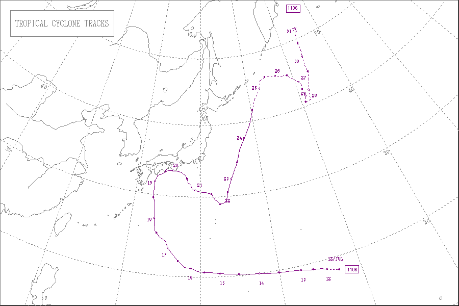
on July 9. The system slowly organized as it developed a low-level circulation
. With low wind shear
and generally favorable environmental conditions, tropical cyclone forecast models anticipated the development
of a tropical cyclone from the system. Early on July 11, the Joint Typhoon Warning Center
(JTWC) issued a tropical cyclone formation alert
, and a few hours later the Japan Meteorological Agency
(JMA) reported the formation of a tropical depression about halfway between Wake Island and the Northern Marianas Islands. The JTWC followed suit by initiating advisories on Tropical Depression 08W.
Upon its formation, the depression tracked westward due to a ridge
to its north. The circulation was initially broad and ill-defined, while its convection was disorganized due to dry air. It was able to intensify due to generally favorable conditions, and the JMA upgraded the depression to Tropical Storm Ma-on at 0600 UTC on July 12. Gradually the thunderstorms became concentrated around the center, despite restricted outflow
to the north and west. Ma-on intensified at a slower than climatological rate, although an eye feature
became evident by early on July 13. At 0000 UTC that day, the JMA upgraded Ma-on to a severe tropical storm, and 18 hours later they upgraded it to a typhoon. By that time, it was located about 970 km (575 mi) southeast of Iwo Jima
. A ragged eye became apparent on satellite imagery, and after developing an anticyclone
aloft, its outflow became much better defined.
By July 15, Typhoon Ma-on had a well-defined eye with the strongest convection in its southern periphery. It continued intensifying, and the JTWC estimated 1-minute sustained winds of 135 mph (220 km/h). Late on July 15, Ma-on weakened slightly due to stronger wind shear, which caused its eyewall to break apart in the northwest quadrant. It re-intensified the next day after an eyewall replacement cycle
commenced. At 0600 UTC on July 16, the JMA estimated peak 10-minute sustained winds of 175 km/h (110 mph) while the typhoon was located about 1185 km (735 mi) southeast of Okinawa
. Around that time, Ma-on began a motion to the northwest due to a weakening of the subtropical ridge
, and it briefly entered the area warned by the Philippine Atmospheric, Geophysical and Astronomical Services Administration
(PAGASA); the agency gave it the local name Ineng.
Late on July 17, Ma-on underwent another eyewall replacement cycle and weakened, despite developing improved outflow and convection in the northern quadrant. The typhoon's large size prevented re-intensification – gale
force winds extended 370 km (200 mi) east of the center. In addition, the intrusion of dry air diminished thunderstorms in the western periphery. By July 18, Ma-on reached the western extent of the ridge and began a motion to the north toward Japan. The next day, it turned to the northeast as it paralleled the Japan coastline just offshore. According to the JTWC, Ma-on briefly weakened to a tropical storm before re-intensifying into a typhoon, making landfall
along the Kii Peninsula
in Honshu
. The JMA maintained the system as a typhoon until 0000 UTC on July 20, when Ma-on moved ashore. By the time it moved across Japan, the storm was moving due eastward, and after emerging from the country it turned to the southeast. Increased wind shear displaced the convection to the east, although slight re-intensification was expected. However, the JTWC downgraded Ma-on to a tropical depression on July 21 after the storm lost much of its convection. The circulation became ill-defined, and the JTWC discontinued advisories on July 22, noting the system was in the process of dissipation
. However, the JMA maintained Ma-on as a severe tropical storm until July 23, by which time the storm had turned to the northeast. The agency discontinued advisories on July 24.
office issued a tropical storm watch
for Agrihan
, Pagan
, and Alamagan
. It was later upgraded to a tropical storm warning after Ma-on became a typhoon, which was canceled after the storm passed the islands to the north. The typhoon produced high waves in Guam, as well as gusty winds and precipitation in an outer feeder band.
On July 18, the storm was predicted to affect the Japanese islands of Shikoku
and southern Honshu
between July 19 and 20, and possibly make landfall on Wakayama Prefecture
.
Tropical cyclone naming
Tropical cyclones have officially been named since 1945 and are named for a variety of reasons, which include to facilitate communications between forecasters and the public when forecasts, watches, and warnings are issued. Names also reduce confusion about what storm is being described, as more...
and second typhoon of the 2011 Pacific typhoon season
2011 Pacific typhoon season
The 2011 Pacific typhoon season was the time of the year in which tropical cyclones form in the Western Pacific Ocean. The season ran throughout 2011 with most tropical cyclones forming between May and November. The scope of this article is limited to the Pacific Ocean to the north of the equator...
.
Meteorological history
The origins of the typhoon were from an area of convection that persisted near Wake IslandWake Island
Wake Island is a coral atoll having a coastline of in the North Pacific Ocean, located about two-thirds of the way from Honolulu west to Guam east. It is an unorganized, unincorporated territory of the United States, administered by the Office of Insular Affairs, U.S. Department of the Interior...
on July 9. The system slowly organized as it developed a low-level circulation
Atmospheric circulation
Atmospheric circulation is the large-scale movement of air, and the means by which thermal energy is distributed on the surface of the Earth....
. With low wind shear
Wind shear
Wind shear, sometimes referred to as windshear or wind gradient, is a difference in wind speed and direction over a relatively short distance in the atmosphere...
and generally favorable environmental conditions, tropical cyclone forecast models anticipated the development
Tropical cyclogenesis
Tropical cyclogenesis is the term that describes the development and strengthening of a tropical cyclone in the atmosphere. The mechanisms through which tropical cyclogenesis occurs are distinctly different from those through which mid-latitude cyclogenesis occurs...
of a tropical cyclone from the system. Early on July 11, the Joint Typhoon Warning Center
Joint Typhoon Warning Center
The Joint Typhoon Warning Center is a joint United States Navy – United States Air Force task force located at the Naval Maritime Forecast Center in Pearl Harbor, Hawaii...
(JTWC) issued a tropical cyclone formation alert
Tropical Cyclone Formation Alert
A Tropical Cyclone Formation Alert is a bulletin released by the U.S. Navy-operated Joint Typhoon Warning Center in Honolulu, Hawaii or the Naval Maritime Forecast Center in Norfolk, Virginia, warning of the possibility of a tropical cyclone forming from a tropical disturbance that has been...
, and a few hours later the Japan Meteorological Agency
Japan Meteorological Agency
The or JMA, is the Japanese government's weather service. Charged with gathering and reporting weather data and forecasts in Japan, it is a semi-autonomous part of the Ministry of Land, Infrastructure and Transport...
(JMA) reported the formation of a tropical depression about halfway between Wake Island and the Northern Marianas Islands. The JTWC followed suit by initiating advisories on Tropical Depression 08W.
Upon its formation, the depression tracked westward due to a ridge
Ridge (meteorology)
A ridge is an elongated region of relatively high atmospheric pressure, the opposite of a trough....
to its north. The circulation was initially broad and ill-defined, while its convection was disorganized due to dry air. It was able to intensify due to generally favorable conditions, and the JMA upgraded the depression to Tropical Storm Ma-on at 0600 UTC on July 12. Gradually the thunderstorms became concentrated around the center, despite restricted outflow
Outflow (meteorology)
Outflow, in meteorology, is air that flows outwards from a storm system. It is associated with ridging, or anticyclonic flow. In the low levels of the troposphere, outflow radiates from thunderstorms in the form of a wedge of rain-cooled air, which is visible as a thin rope-like cloud on weather...
to the north and west. Ma-on intensified at a slower than climatological rate, although an eye feature
Eye (cyclone)
The eye is a region of mostly calm weather found at the center of strong tropical cyclones. The eye of a storm is a roughly circular area and typically 30–65 km in diameter. It is surrounded by the eyewall, a ring of towering thunderstorms where the second most severe weather of a cyclone...
became evident by early on July 13. At 0000 UTC that day, the JMA upgraded Ma-on to a severe tropical storm, and 18 hours later they upgraded it to a typhoon. By that time, it was located about 970 km (575 mi) southeast of Iwo Jima
Iwo Jima
Iwo Jima, officially , is an island of the Japanese Volcano Islands chain, which lie south of the Ogasawara Islands and together with them form the Ogasawara Archipelago. The island is located south of mainland Tokyo and administered as part of Ogasawara, one of eight villages of Tokyo...
. A ragged eye became apparent on satellite imagery, and after developing an anticyclone
Anticyclone
An anticyclone is a weather phenomenon defined by the United States' National Weather Service's glossary as "[a] large-scale circulation of winds around a central region of high atmospheric pressure, clockwise in the Northern Hemisphere, counterclockwise in the Southern Hemisphere"...
aloft, its outflow became much better defined.
By July 15, Typhoon Ma-on had a well-defined eye with the strongest convection in its southern periphery. It continued intensifying, and the JTWC estimated 1-minute sustained winds of 135 mph (220 km/h). Late on July 15, Ma-on weakened slightly due to stronger wind shear, which caused its eyewall to break apart in the northwest quadrant. It re-intensified the next day after an eyewall replacement cycle
Eye (cyclone)
The eye is a region of mostly calm weather found at the center of strong tropical cyclones. The eye of a storm is a roughly circular area and typically 30–65 km in diameter. It is surrounded by the eyewall, a ring of towering thunderstorms where the second most severe weather of a cyclone...
commenced. At 0600 UTC on July 16, the JMA estimated peak 10-minute sustained winds of 175 km/h (110 mph) while the typhoon was located about 1185 km (735 mi) southeast of Okinawa
Okinawa Island
Okinawa Island is the largest of the Okinawa Islands and the Ryukyu Islands of Japan, and is home to Naha, the capital of Okinawa Prefecture. The island has an area of...
. Around that time, Ma-on began a motion to the northwest due to a weakening of the subtropical ridge
Subtropical ridge
The subtropical ridge is a significant belt of high pressure situated around the latitudes of 30°N in the Northern Hemisphere and 30°S in the Southern Hemisphere. It is characterized by mostly calm winds, which acts to reduce air quality under its axis by causing fog overnight, and haze during...
, and it briefly entered the area warned by the Philippine Atmospheric, Geophysical and Astronomical Services Administration
Philippine Atmospheric, Geophysical and Astronomical Services Administration
The Philippine Atmospheric, Geophysical and Astronomical Services Administration is a Philippine national institution dedicated to provide flood and typhoon warnings, public weather forecasts and advisories, meteorological, astronomical, climatological, and other specialized information and...
(PAGASA); the agency gave it the local name Ineng.
Late on July 17, Ma-on underwent another eyewall replacement cycle and weakened, despite developing improved outflow and convection in the northern quadrant. The typhoon's large size prevented re-intensification – gale
Gale
A gale is a very strong wind. There are conflicting definitions of how strong a wind must be to be considered a gale. The U.S. government's National Weather Service defines a gale as 34–47 knots of sustained surface winds. Forecasters typically issue gale warnings when winds of this strength are...
force winds extended 370 km (200 mi) east of the center. In addition, the intrusion of dry air diminished thunderstorms in the western periphery. By July 18, Ma-on reached the western extent of the ridge and began a motion to the north toward Japan. The next day, it turned to the northeast as it paralleled the Japan coastline just offshore. According to the JTWC, Ma-on briefly weakened to a tropical storm before re-intensifying into a typhoon, making landfall
Landfall (meteorology)
Landfall is the event of a tropical cyclone or a waterspout coming onto land after being over water. When a waterspout makes landfall it is reclassified as a tornado, which can then cause damage inland...
along the Kii Peninsula
Kii Peninsula
The is the largest peninsula on the island of Honshū in Japan. The area south of the “Central Tectonic Line” is called Nankii , and includes the most poleward living coral reefs in the world due to the presence of the warm Kuroshio Current, though these are threatened by global warming and human...
in Honshu
Honshu
is the largest island of Japan. The nation's main island, it is south of Hokkaido across the Tsugaru Strait, north of Shikoku across the Inland Sea, and northeast of Kyushu across the Kanmon Strait...
. The JMA maintained the system as a typhoon until 0000 UTC on July 20, when Ma-on moved ashore. By the time it moved across Japan, the storm was moving due eastward, and after emerging from the country it turned to the southeast. Increased wind shear displaced the convection to the east, although slight re-intensification was expected. However, the JTWC downgraded Ma-on to a tropical depression on July 21 after the storm lost much of its convection. The circulation became ill-defined, and the JTWC discontinued advisories on July 22, noting the system was in the process of dissipation
Dissipation
In physics, dissipation embodies the concept of a dynamical system where important mechanical models, such as waves or oscillations, lose energy over time, typically from friction or turbulence. The lost energy converts into heat, which raises the temperature of the system. Such systems are called...
. However, the JMA maintained Ma-on as a severe tropical storm until July 23, by which time the storm had turned to the northeast. The agency discontinued advisories on July 24.
Preparations and impact
After Ma-on attained tropical storm status, the Tiyan, Guam National Weather ServiceNational Weather Service
The National Weather Service , once known as the Weather Bureau, is one of the six scientific agencies that make up the National Oceanic and Atmospheric Administration of the United States government...
office issued a tropical storm watch
Tropical cyclone warnings and watches
Warnings and watches are two levels of alert issued by national weather forecasting bodies to coastal areas threatened by the imminent approach of a tropical cyclone of tropical storm or hurricane intensity. They are notices to the local population and civil authorities to make appropriate...
for Agrihan
Agrihan
Agrihan is a stratovolcano which forms an island in the Northern Mariana Islands in the Pacific Ocean. The entire island is a massive volcano which rises over from the ocean floor, and is the fifth largest in the Marianas volcanic arc. At , its summit is the highest point in Micronesia...
, Pagan
Pagan Island
Pagan is an island of the Northern Mariana Islands chain,located at , approximately 320 kilometers northof Saipan.Pagan has an area of 47.23 km² , making it the fourth largest island of the Northern Marianas, and consists of two stratovolcanoes joined by a narrow strip of land.The...
, and Alamagan
Alamagan
The Northern Marianas island of Alamagan is located north from Saipan and is 11.12 km² in area. The island's volcano has a large caldera at the summit. The volcano last erupted around 870 AD, with an error bar of 100 years. It involved pyroclastic flows, and had a VEI of 4...
. It was later upgraded to a tropical storm warning after Ma-on became a typhoon, which was canceled after the storm passed the islands to the north. The typhoon produced high waves in Guam, as well as gusty winds and precipitation in an outer feeder band.
On July 18, the storm was predicted to affect the Japanese islands of Shikoku
Shikoku
is the smallest and least populous of the four main islands of Japan, located south of Honshū and east of the island of Kyūshū. Its ancient names include Iyo-no-futana-shima , Iyo-shima , and Futana-shima...
and southern Honshu
Honshu
is the largest island of Japan. The nation's main island, it is south of Hokkaido across the Tsugaru Strait, north of Shikoku across the Inland Sea, and northeast of Kyushu across the Kanmon Strait...
between July 19 and 20, and possibly make landfall on Wakayama Prefecture
Wakayama Prefecture
is a prefecture of Japan located on the Kii Peninsula in the Kansai region on Honshū island. The capital is the city of Wakayama.- History :Present-day Wakayama is mostly the western part of the province of Kii.- 1953 Wakayama Prefecture flood disaster :...
.
See also
- Other storms of the same nameTyphoon Ma-onThe name Ma-on was used for two typhoons in the western Pacific Ocean.*2004's Typhoon Ma-on - Typhoon Ma-on is notable for becoming a Super Typhoon and making landfall on the Izu Peninsula, Honshū, Japan, causing 6 deaths....
- 2011 Pacific typhoon season2011 Pacific typhoon seasonThe 2011 Pacific typhoon season was the time of the year in which tropical cyclones form in the Western Pacific Ocean. The season ran throughout 2011 with most tropical cyclones forming between May and November. The scope of this article is limited to the Pacific Ocean to the north of the equator...
External links
- The JMA's Best Track Data on Typhoon Ma-on (1106)
- The JMA's RSMC Best Track Data (Graphics) on Typhoon Ma-on (1106)
- The JMA's RSMC Best Track Data (Text)