
.gif)
Typhoon Jangmi (2008)
Encyclopedia
Typhoon Jangmi was the most intense tropical cyclone
to develop worldwide during 2008 with a pressure of 905 hPa. Structural damage from the typhoon is estimated at $240 million (USD) and agricultural losses totaled to NT$
16,375,000 ($494,262 USD).
, to the south-west of Guam
. Later that day the Joint Typhoon Warning Center
assessed the disturbance's chances of becoming a significant tropical cyclone
within 24 hours as poor. This assessment was due to the disturbance having a weak Low level Circulation Center
. Later that day the JTWC reassessed its chances of becoming a significant tropical cyclone within 24 hours to "Fair". This was because the disturbance's Low Level Circulation Center had developed further within the previous six hours while remaining stationary. The Japan Meteorological Agency
then designated the disturbance as a minor tropical depression, later that evening the JTWC upgraded the disturbances chances of developing in to a significant tropical cyclone to "Good". This came as the JTWC issued a Tropical Cyclone Formation Alert
on the disturbance as it moved towards the west. Later on September 23, the JTWC reported that the disturbance had intensified in to a tropical depression and designated it as Tropical Depression 19W.
Early on September 24, the JMA started to issue full advisories on the tropical depression, while the JTWC reported that the depression had intensified in to a tropical storm. Early that afternoon the JMA assigned the international name of Jangmi, to the tropical storm. Jangmi then moved in to PAGASA's Area of Responsibility who assigned the local name Ofel to tropical storm Jangmi. The JMA then reported that Jangmi had intensified in to a severe tropical storm early the next day. Later that day both the JMA and the JTWC reported that Jangmi had intensified further and had become a Typhoon. Early the next day the JTWC reported that Jangmi had intensified in to a category two typhoon on the Saffir-Simpson Hurricane Scale
with winds of 90 knots (105 mph 165 km/h). While the JMA were reporting that Jangmi had winds of 80 knots Later that day the JTWC reported that Jangmi had rapidly intensified within the last six hours to become a category four typhoon. Meanwhile the JMA were reporting that Jangmi had winds of 100 knots Early on September 27 the JTWC reported that Jangmi had continued to intensify and reached its peak wind speeds of 135 kts (155 mph, 250 km/h) which made Jangmi a super typhoon. At this time the JMA were still reporting that Jangmi had winds of 100 knots (196 km/h). Later that day as the outer bands of Jangmi started to interact with the Taiwan's
coast, the JMA reported that Jangmi had reached its peak winds of 115 knots (225.4 km/h) and had a minimum pressure of 910 hPa
.
Throughout September 27 the JTWC kept Jangmi as a category four super typhoon with winds of 135 knots (264.6 km/h). Early the next day, Jangmi weakened into a Category four typhoon with winds of 115 kts (130 mph 210 km/h). While the JMA reported that Jangmi had winds of 110 knots (215.6 km/h). Later that morning, Jangmi made landfall in Yilan County on the east coast of Taiwan
. The JMA reported that Jangmi had winds of 105 knots (205.8 km/h) while the JTWC reported that Jangmi had winds of 115 kts (130 mph 210 km/h) at the time of landfall. After making landfall on Taiwan during September 28, Jangmi weakened in to a category two typhoon with 85 knots (166.6 km/h), (100 mph, 155 km/h). The JMA at this time were reporting that Jangmi had winds of 75 knots (147 km/h).
Later that day, Jangmi moved to the north-east and moved back over the East China Sea
. Jangmi then weakened into a category one typhoon while the JMA reported that Jangmi had weakened into a Severe Tropical Storm. Early the next morning the JTWC downgraded typhoon Jangmi to a tropical storm. As Jangmi moved closer towards Japan and out of PAGASA's area of responsibility the JMA downgraded Jangmi to a tropical storm. Late the next day the JTWC reported that the Jangmi had become extra tropical. As a result of this the JTWC issued their final advisory on Jangmi. The JMA then followed suit within their next advisory, declaring it as a developing low. The JMA reported in their best track that the low dissipated on October 5.
Operationally the Joint Typhoon Warning Center
measured the peak wind speeds at 135 knots (264.6 km/h), which is a category four super typhoon. During their post storm analysis the JTWC determined that Jangmi had carried on intensifying during September 27, and had reached peak winds of 270 km/h (165 mph) later that day. This made Jangmi a category five super typhoon on the Saffir Simpson Hurricane Scale. Within their post storm analysis the Japan Meteorological Agency
revised the lowest pressure of Jangmi. Operationally the JMA measured the lowest pressure of Jangmi at 910 hPa, However in their best track the lowest pressure they measured was 905 hPa.
proper called off classes and government work for Sunday, September 28, while Penghu County in the Taiwan Strait
called off classes for the afternoon. For public safety reasons, September 29 was later declared a public holiday as well. Ferry service from Taitung
to Green Island was canceled for three days, starting on September 28. Taiwan Railways Administration and Taiwan High Speed Rail
trains were temporarily suspended as well.
in Yilan County registered 692 mm (27.24 in) of rain according to the 0415 UTC advisory while Nangang in Taipei City in northern Taiwan
reported 463 mm (18.22 in) of precipitation. The highest recorded rainfall was registered in Tatung Town at 1,124 mm (44.27 in). However, some estimates showed over 1,400 mm (55 in) falling the mountainous regions. Landslides were reported in many mountain areas already saturated by Typhoon Sinlaku
, which passed by two weeks earlier. About 154,266 residences on the island lost power due to the storm. A bus near Yilan City
was blown over by the strong winds produced by the storm, injuring the 36 passengers inside. One man was killed after he fell into a flooded rice paddy and a teenage girl was electrocuted after an electrical wire fell on her.
on September 27, bringing strong winds and moderate rainfall, peaking at 137 mm (5.4 in) to the islands. Ishigaki Island sustained the most severe damage after a dike collapsed, flooding the surrounding areas. Much of the prefecture was left without power as winds gusted to 110 km/h (70 mph). Throughout the prefecture, four people were killed and six others were injured, two of whom sustained severe injuries. Damage from the storm amounted to 65.2 million yen ($746,670 USD). By October 1, the remnants of Jangmi brought heavy rains and strong winds to Kyūshū
. The highest rainfall total was measured in Satsumakashiwabaru, in the Kagoshima Prefecture
, at 380 mm (15 in). In the prefecture, these rains triggered 42 landslides and flooded seven homes, three of which were left with severe damage. A total of 334 hectares of farmland was damaged by Jangmi, leaving 15.4 million yen ($176,360 USD) in losses. In Miyazaki Prefecture
, one person was injured and three homes were damaged after a hillside collapsed.
in both the western Pacific and worldwide during 2008. Being the only Category 5 equivalent storm in any basin during 2008, it marked the lowest number of cyclones of this intensity since 1974 when there were none. However, operationally, Jangmi was not considered a Category 5 by the JTWC; the initial intensity was set at 250 km/h (155 mph) and was later raised during post-season analysis.
The name Changmi was one of the 10 original names submitted by the Republic of Korea to the ESCAP/WMO Typhoon Committee for use from January 1, 2000. The name 'Changmi' is Korean
for 'rose
' and was last used in the 2002 Pacific typhoon season
. At the 2007 meeting of the typhoon committee, the Republic of Korea submitted a request to change the spelling of Changmi to Jangmi. This request was approved with the change being effective from January 1, 2008.
The Philippine Atmospheric, Geophysical and Astronomical Services Administration
(PAGASA) assigned the local name of Ofel to Jangmi. Ofel was last used by PAGASA to name a tropical depression in the Philippines in 2004 to name Tropical Storm Haima. If the name Ofel is not retired by PAGASA at the end of the 2008 Typhoon Season then it will be reused in the 2012 Pacific typhoon season.
Tropical cyclone
A tropical cyclone is a storm system characterized by a large low-pressure center and numerous thunderstorms that produce strong winds and heavy rain. Tropical cyclones strengthen when water evaporated from the ocean is released as the saturated air rises, resulting in condensation of water vapor...
to develop worldwide during 2008 with a pressure of 905 hPa. Structural damage from the typhoon is estimated at $240 million (USD) and agricultural losses totaled to NT$
New Taiwan dollar
The New Taiwan dollar , or simply Taiwan dollar, is the official currency of the Taiwan Area of the Republic of China since 1949, when it replaced the Old Taiwan dollar...
16,375,000 ($494,262 USD).
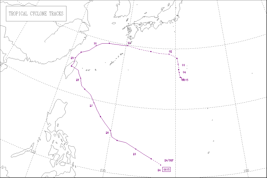
Meteorological history
On September 23, 2008, a tropical disturbance formed in the western Pacific oceanPacific Ocean
The Pacific Ocean is the largest of the Earth's oceanic divisions. It extends from the Arctic in the north to the Southern Ocean in the south, bounded by Asia and Australia in the west, and the Americas in the east.At 165.2 million square kilometres in area, this largest division of the World...
, to the south-west of Guam
Guam
Guam is an organized, unincorporated territory of the United States located in the western Pacific Ocean. It is one of five U.S. territories with an established civilian government. Guam is listed as one of 16 Non-Self-Governing Territories by the Special Committee on Decolonization of the United...
. Later that day the Joint Typhoon Warning Center
Joint Typhoon Warning Center
The Joint Typhoon Warning Center is a joint United States Navy – United States Air Force task force located at the Naval Maritime Forecast Center in Pearl Harbor, Hawaii...
assessed the disturbance's chances of becoming a significant tropical cyclone
Tropical cyclone
A tropical cyclone is a storm system characterized by a large low-pressure center and numerous thunderstorms that produce strong winds and heavy rain. Tropical cyclones strengthen when water evaporated from the ocean is released as the saturated air rises, resulting in condensation of water vapor...
within 24 hours as poor. This assessment was due to the disturbance having a weak Low level Circulation Center
Tropical cyclone
A tropical cyclone is a storm system characterized by a large low-pressure center and numerous thunderstorms that produce strong winds and heavy rain. Tropical cyclones strengthen when water evaporated from the ocean is released as the saturated air rises, resulting in condensation of water vapor...
. Later that day the JTWC reassessed its chances of becoming a significant tropical cyclone within 24 hours to "Fair". This was because the disturbance's Low Level Circulation Center had developed further within the previous six hours while remaining stationary. The Japan Meteorological Agency
Japan Meteorological Agency
The or JMA, is the Japanese government's weather service. Charged with gathering and reporting weather data and forecasts in Japan, it is a semi-autonomous part of the Ministry of Land, Infrastructure and Transport...
then designated the disturbance as a minor tropical depression, later that evening the JTWC upgraded the disturbances chances of developing in to a significant tropical cyclone to "Good". This came as the JTWC issued a Tropical Cyclone Formation Alert
Tropical Cyclone Formation Alert
A Tropical Cyclone Formation Alert is a bulletin released by the U.S. Navy-operated Joint Typhoon Warning Center in Honolulu, Hawaii or the Naval Maritime Forecast Center in Norfolk, Virginia, warning of the possibility of a tropical cyclone forming from a tropical disturbance that has been...
on the disturbance as it moved towards the west. Later on September 23, the JTWC reported that the disturbance had intensified in to a tropical depression and designated it as Tropical Depression 19W.
Early on September 24, the JMA started to issue full advisories on the tropical depression, while the JTWC reported that the depression had intensified in to a tropical storm. Early that afternoon the JMA assigned the international name of Jangmi, to the tropical storm. Jangmi then moved in to PAGASA's Area of Responsibility who assigned the local name Ofel to tropical storm Jangmi. The JMA then reported that Jangmi had intensified in to a severe tropical storm early the next day. Later that day both the JMA and the JTWC reported that Jangmi had intensified further and had become a Typhoon. Early the next day the JTWC reported that Jangmi had intensified in to a category two typhoon on the Saffir-Simpson Hurricane Scale
Saffir-Simpson Hurricane Scale
The Saffir–Simpson Hurricane Scale , or the Saffir–Simpson Hurricane Wind Scale , classifies hurricanes — Western Hemisphere tropical cyclones that exceed the intensities of tropical depressions and tropical storms — into five categories distinguished by the intensities of their sustained winds...
with winds of 90 knots (105 mph 165 km/h). While the JMA were reporting that Jangmi had winds of 80 knots Later that day the JTWC reported that Jangmi had rapidly intensified within the last six hours to become a category four typhoon. Meanwhile the JMA were reporting that Jangmi had winds of 100 knots Early on September 27 the JTWC reported that Jangmi had continued to intensify and reached its peak wind speeds of 135 kts (155 mph, 250 km/h) which made Jangmi a super typhoon. At this time the JMA were still reporting that Jangmi had winds of 100 knots (196 km/h). Later that day as the outer bands of Jangmi started to interact with the Taiwan's
Taiwan
Taiwan , also known, especially in the past, as Formosa , is the largest island of the same-named island group of East Asia in the western Pacific Ocean and located off the southeastern coast of mainland China. The island forms over 99% of the current territory of the Republic of China following...
coast, the JMA reported that Jangmi had reached its peak winds of 115 knots (225.4 km/h) and had a minimum pressure of 910 hPa
HPA
-Organizations:*Halifax Port Authority, a port authority in Canada*Hamburg Port Authority, the port authority for the Port of Hamburg, Germany*Health Protection Agency, a health organization in the United Kingdom...
.
Throughout September 27 the JTWC kept Jangmi as a category four super typhoon with winds of 135 knots (264.6 km/h). Early the next day, Jangmi weakened into a Category four typhoon with winds of 115 kts (130 mph 210 km/h). While the JMA reported that Jangmi had winds of 110 knots (215.6 km/h). Later that morning, Jangmi made landfall in Yilan County on the east coast of Taiwan
Taiwan
Taiwan , also known, especially in the past, as Formosa , is the largest island of the same-named island group of East Asia in the western Pacific Ocean and located off the southeastern coast of mainland China. The island forms over 99% of the current territory of the Republic of China following...
. The JMA reported that Jangmi had winds of 105 knots (205.8 km/h) while the JTWC reported that Jangmi had winds of 115 kts (130 mph 210 km/h) at the time of landfall. After making landfall on Taiwan during September 28, Jangmi weakened in to a category two typhoon with 85 knots (166.6 km/h), (100 mph, 155 km/h). The JMA at this time were reporting that Jangmi had winds of 75 knots (147 km/h).
Later that day, Jangmi moved to the north-east and moved back over the East China Sea
East China Sea
The East China Sea is a marginal sea east of China. It is a part of the Pacific Ocean and covers an area of 1,249,000 km² or 750,000 square miles.-Geography:...
. Jangmi then weakened into a category one typhoon while the JMA reported that Jangmi had weakened into a Severe Tropical Storm. Early the next morning the JTWC downgraded typhoon Jangmi to a tropical storm. As Jangmi moved closer towards Japan and out of PAGASA's area of responsibility the JMA downgraded Jangmi to a tropical storm. Late the next day the JTWC reported that the Jangmi had become extra tropical. As a result of this the JTWC issued their final advisory on Jangmi. The JMA then followed suit within their next advisory, declaring it as a developing low. The JMA reported in their best track that the low dissipated on October 5.
Operationally the Joint Typhoon Warning Center
Joint Typhoon Warning Center
The Joint Typhoon Warning Center is a joint United States Navy – United States Air Force task force located at the Naval Maritime Forecast Center in Pearl Harbor, Hawaii...
measured the peak wind speeds at 135 knots (264.6 km/h), which is a category four super typhoon. During their post storm analysis the JTWC determined that Jangmi had carried on intensifying during September 27, and had reached peak winds of 270 km/h (165 mph) later that day. This made Jangmi a category five super typhoon on the Saffir Simpson Hurricane Scale. Within their post storm analysis the Japan Meteorological Agency
Japan Meteorological Agency
The or JMA, is the Japanese government's weather service. Charged with gathering and reporting weather data and forecasts in Japan, it is a semi-autonomous part of the Ministry of Land, Infrastructure and Transport...
revised the lowest pressure of Jangmi. Operationally the JMA measured the lowest pressure of Jangmi at 910 hPa, However in their best track the lowest pressure they measured was 905 hPa.
Preparations
Taiwan made hbv preparations for a late Sunday landfall. All local governments in TaiwanTaiwan
Taiwan , also known, especially in the past, as Formosa , is the largest island of the same-named island group of East Asia in the western Pacific Ocean and located off the southeastern coast of mainland China. The island forms over 99% of the current territory of the Republic of China following...
proper called off classes and government work for Sunday, September 28, while Penghu County in the Taiwan Strait
Taiwan Strait
The Taiwan Strait or Formosa Strait, formerly known as the Black Ditch, is a 180-km-wide strait separating Mainland China and Taiwan. The strait is part of the South China Sea and connects to East China Sea to the northeast...
called off classes for the afternoon. For public safety reasons, September 29 was later declared a public holiday as well. Ferry service from Taitung
Taitung City
Taitung City is the county seat of Taitung County, Taiwan. It lies on the southeast coast of Taiwan facing the Pacific Ocean.The city is served by Taitung Airport. Taitung is a gateway to Green Island and Orchid Island, both of which are very popular among Taiwanese tourists.-History:Taitung...
to Green Island was canceled for three days, starting on September 28. Taiwan Railways Administration and Taiwan High Speed Rail
Taiwan High Speed Rail
Taiwan High Speed Rail is a high-speed rail line that runs approximately along the west coast of the Republic of China from the national capital of Taipei to the southern city of Kaohsiung...
trains were temporarily suspended as well.
China
Late on September 27 the Chinese Meteorological Association issued a Red Typhoon warning in preparation for super typhoon Jangmi.Taiwan
Taiping MountainTaiping Mountain
Taiping Mountain or Taipingshan is located Datong Township in northern Taiwan's Yilan County. It is one of Taiwan's three major forest recreation areas. At 1,950 meters above sea level, Taiping Mountain has nurtured an environment rich in ecological resources.-Notes:...
in Yilan County registered 692 mm (27.24 in) of rain according to the 0415 UTC advisory while Nangang in Taipei City in northern Taiwan
Taiwan
Taiwan , also known, especially in the past, as Formosa , is the largest island of the same-named island group of East Asia in the western Pacific Ocean and located off the southeastern coast of mainland China. The island forms over 99% of the current territory of the Republic of China following...
reported 463 mm (18.22 in) of precipitation. The highest recorded rainfall was registered in Tatung Town at 1,124 mm (44.27 in). However, some estimates showed over 1,400 mm (55 in) falling the mountainous regions. Landslides were reported in many mountain areas already saturated by Typhoon Sinlaku
Typhoon Sinlaku (2008)
Typhoon Sinlaku was a typhoon which affected the Philippines, Taiwan, China and Japan...
, which passed by two weeks earlier. About 154,266 residences on the island lost power due to the storm. A bus near Yilan City
Yilan City
Yilan City historically spelled Ilan or I-lan, is the capital of Yilan County, Taiwan. It is on the north side of Lanyang River. The first Han Chinese settled there in 1802....
was blown over by the strong winds produced by the storm, injuring the 36 passengers inside. One man was killed after he fell into a flooded rice paddy and a teenage girl was electrocuted after an electrical wire fell on her.
Japan
Prior to striking Taiwan, Typhoon Jangmi brushed Okinawa PrefectureOkinawa Prefecture
is one of Japan's southern prefectures. It consists of hundreds of the Ryukyu Islands in a chain over long, which extends southwest from Kyūshū to Taiwan. Okinawa's capital, Naha, is located in the southern part of Okinawa Island...
on September 27, bringing strong winds and moderate rainfall, peaking at 137 mm (5.4 in) to the islands. Ishigaki Island sustained the most severe damage after a dike collapsed, flooding the surrounding areas. Much of the prefecture was left without power as winds gusted to 110 km/h (70 mph). Throughout the prefecture, four people were killed and six others were injured, two of whom sustained severe injuries. Damage from the storm amounted to 65.2 million yen ($746,670 USD). By October 1, the remnants of Jangmi brought heavy rains and strong winds to Kyūshū
Kyushu
is the third largest island of Japan and most southwesterly of its four main islands. Its alternate ancient names include , , and . The historical regional name is referred to Kyushu and its surrounding islands....
. The highest rainfall total was measured in Satsumakashiwabaru, in the Kagoshima Prefecture
Kagoshima Prefecture
is a prefecture of Japan located on the island of Kyushu. The capital is the city of Kagoshima.- Geography :Kagoshima Prefecture is located at the southwest tip of Kyushu and includes a chain of islands stretching further to the southwest for a few hundred kilometers...
, at 380 mm (15 in). In the prefecture, these rains triggered 42 landslides and flooded seven homes, three of which were left with severe damage. A total of 334 hectares of farmland was damaged by Jangmi, leaving 15.4 million yen ($176,360 USD) in losses. In Miyazaki Prefecture
Miyazaki Prefecture
is a prefecture of Japan located on the island of Kyushu. The capital is the city of Miyazaki.- History :Historically, after the Meiji Restoration, Hyūga Province was renamed Miyazaki Prefecture....
, one person was injured and three homes were damaged after a hillside collapsed.
Intensity and naming
On September 27, Typhoon Jangmi attained its peak intensity with winds of 215 km/h (135 mph) and a barometric pressure of 905 mbar (hPa; 26.72 inHg) according to the JMA. At the same time, the JTWC classified the system as a stronger storm, peaking as a Category 5 equivalent typhoon with winds of 270 km/h (165 mph) with a slightly higher pressure of 918 mbar (hPa; 27.11 inHg). This made Jangmi the strongest tropical cycloneTropical cyclone
A tropical cyclone is a storm system characterized by a large low-pressure center and numerous thunderstorms that produce strong winds and heavy rain. Tropical cyclones strengthen when water evaporated from the ocean is released as the saturated air rises, resulting in condensation of water vapor...
in both the western Pacific and worldwide during 2008. Being the only Category 5 equivalent storm in any basin during 2008, it marked the lowest number of cyclones of this intensity since 1974 when there were none. However, operationally, Jangmi was not considered a Category 5 by the JTWC; the initial intensity was set at 250 km/h (155 mph) and was later raised during post-season analysis.
The name Changmi was one of the 10 original names submitted by the Republic of Korea to the ESCAP/WMO Typhoon Committee for use from January 1, 2000. The name 'Changmi' is Korean
Korean language
Korean is the official language of the country Korea, in both South and North. It is also one of the two official languages in the Yanbian Korean Autonomous Prefecture in People's Republic of China. There are about 78 million Korean speakers worldwide. In the 15th century, a national writing...
for 'rose
Rose
A rose is a woody perennial of the genus Rosa, within the family Rosaceae. There are over 100 species. They form a group of erect shrubs, and climbing or trailing plants, with stems that are often armed with sharp prickles. Flowers are large and showy, in colours ranging from white through yellows...
' and was last used in the 2002 Pacific typhoon season
2002 Pacific typhoon season
A Tropical Cyclone Formation Alert was issued on July 19 for a Tropical Disturbance that was located east of the international Date Line. The Next day the Disturbance crossed the international date line and was classified as a Tropical Depression by the JMA. The JMA then upgraded the depression to...
. At the 2007 meeting of the typhoon committee, the Republic of Korea submitted a request to change the spelling of Changmi to Jangmi. This request was approved with the change being effective from January 1, 2008.
The Philippine Atmospheric, Geophysical and Astronomical Services Administration
Philippine Atmospheric, Geophysical and Astronomical Services Administration
The Philippine Atmospheric, Geophysical and Astronomical Services Administration is a Philippine national institution dedicated to provide flood and typhoon warnings, public weather forecasts and advisories, meteorological, astronomical, climatological, and other specialized information and...
(PAGASA) assigned the local name of Ofel to Jangmi. Ofel was last used by PAGASA to name a tropical depression in the Philippines in 2004 to name Tropical Storm Haima. If the name Ofel is not retired by PAGASA at the end of the 2008 Typhoon Season then it will be reused in the 2012 Pacific typhoon season.
External links
- The JMA's Best Track Data on Typhoon Jangmi (0815)
- The JMA's RSMC Best Track Data (Graphics) on Typhoon Jangmi (0815)
- The JMA's RSMC Best Track Data (Text)
- The JTWC's Best Track Data on Super Typhoon 19W (Jangmi)
- Typhoon Jangmi strikes Taiwan – A video from BBC