

Typhoon Conson (2010)
Encyclopedia
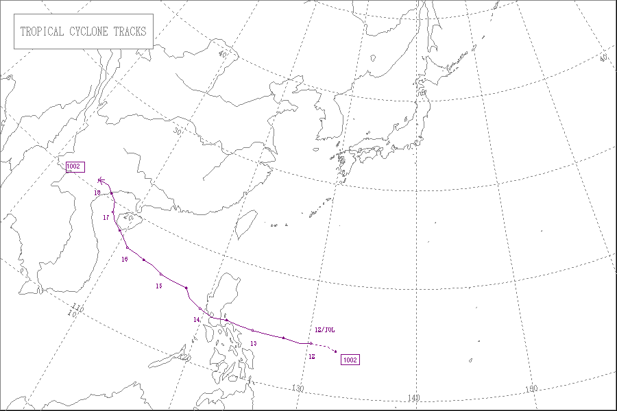
Typhoon Conson was the second tropical cyclone
during the 2010 Pacific typhoon season
to impact the Philippines
. Developing out of a tropical disturbance east of the Philippines on July 11, 2010, Conson quickly developed as it tracked nearly due west. Favorable environmental conditions, such as low wind shear
and warm sea surface temperatures, allowed the system to intensify into a severe tropical storm by July 12. Around the same time, the JTWC assessed the storm to have been equivalent to a Category 1 hurricane. The following day, Conson struck Quezon Province
with winds of 100 km/h (65 mph)Wind speeds are listed by 10-minute standards unless otherwise noted. before weakening. After crossing the archipelago, the storm entered the South China Sea
where it was able to re-strengthen. By July 16, Conson attained typhoon status as it neared the southern Chinese island of Hainan
. After brushing the island at peak intensity with sustained winds estimated at 130 km/h (80 mph), the storm weakened in the Gulf of Tonkin
due to less favorable conditions. The storm eventually made landfall near Ha Noi, Vietnam
on July 17 and dissipated the following day.
In the Philippines, Conson produced widespread, torrential rains which triggered significant flooding. At least 76 people are known to have been killed across the country and 72 others are listed as missing. Preliminary damage estimates were placed at PHP
189 million (US$4.1 million). In China, at least two people have been killed due to wind-related incidents. Hainan Province sustained significant damage from the typhoon, with damage estimated at ¥
500 million (US$73.8 million). Widespread damage was reported in Vietnam where at least two people were killed and 17 others were listed as missing.
(JTWC), reported that a tropical disturbance had persisted within the vicinity of Yap
island. Satellite imagery showed that the disturbance had a weak circulation which was stretching over Yap with disorganized convection. The disturbance was located to the south of a tropical upper tropospheric trough and was in an area of weak vertical windshear. During the next day, deep convection around the disturbance increased whilst a low to mid level circulation center appeared on satellite imagery. Early on July 11, the Japan Meteorological Agency
(JMA) reported that the disturbance had intensified into a tropical depression, whilst the JTWC issued a tropical cyclone formation alert
as the disturbance had consolidated and had multiple convective bands flowing into its low level circulation center.
During that afternoon the JTWC reported that the disturbance had intensified into Tropical Depression 03W and initiated advisories on the system, before reporting later that day due to favorable conditions it had intensified into a tropical storm. PAGASA also reported that afternoon that the disturbance had intensified into a depression and named it as Basyang. At 0000 UTC, the next day the JMA reported that Basyang had intensified into a weak tropical storm and assigned it the name Conson and the international designation of 1002. Twelve hours later, as Conson moved through favorable condition and along the southwestern edge of the subtropical ridge of high pressure, the JMA reported that the storm had rapidly intensified into a Severe Tropical Storm with windspeeds of 100 km/h (65 mph). Later that day at 1800 UTC the JTWC reported that after convection around the system had expanded and microwave imagery showed an eye like feature, Conson had intensified into a typhoon. The JMA also reported at 1800 UTC that Conson had reached its initial 10-minute peak sustained windspeeds of 110 km/h (75 mph) despite predicting that it would intensify into a typhoon before making landfall in the Philippines. Early on July 13 the JTWC also reported that Conson had reached its initial 1-minute peak sustained windspeeds of 130 km/h (70 mph).
, Isabela and Aurora under Storm Signal Number One, warning them to prepare for flash floods, landslides and strong winds. The next day, in addition to the signals already in force, PAGASA placed Quezon
, Polillo Island
, Camarines Norte
and Catanduanes
under Storm Signal Number One. Later that day, PAGASA placed the provinces of Catanduanes, Camarines Norte, Polillo Island, Aurora, Quirino and Isabela under Storm Signal Number Two while placing the provinces of Camarines Sur, Albay, Quezon, Rizal, Bulacan, Nueva Ecija, Nueva Vizcaya, Ifugao, Benguet, Mt. Province, Kalinga, Pampanga, Tarlac, Pangasinan, La Union, Abra, Ilocos Sur under Storm Signal Number One. On July 13, in the eyes of PAGASA, Conson had intensified into a typhoon. PAGASA made major revisions to the storm signals placing Catanduanes, Camarines Norte, Northern Quezon, Polillo Island and Aurora under Storm Signal Number Three. They also placed Camarines Sur, Laguna, Rizal, Bulacan, Nueva Ecija, Nueva Vizcaya, Quirino, Ifugao and Isabela under Storm Signal Number Two and Metro Manila, Albay, Marinduque, Batangas, Cavite, Bataan, Pampanga, Zambales, Tarlac, Pangasinan, La Union, Benguet, Mt. Province, Ilocos Sur, Kalinga, Apayao, Abra and Cagayan under Storm Signal Number One. After Conson had made landfall in Southern Luzon, PAGASA placed Metro Manila under Storm Signal Number Two. On July 14 at 1500 UTC, PAGASA lowered storm signals in all provinces.
under the Standby Signal Number 1
, late on July 14, before the Hong Kong Observatory
also issued the Standby Signal Number 1, early the next day for Hong Kong. During the afternoon of July 15 the China Meteorological Agency issued a Yellow typhoon warning for parts of Hainan Province and the western Guangdong
coast.
Prior to the storm's arrival, officials in Hainan and Guangdong provinces initiated large-scale evacuations. An estimated 40,000 and 20,000 were relocated in Hainan and Guangdong respectively.
When Conson made landfall in Quezon province at (PST)/ 15:00 (UTC), power supply in Metro Manila, including 35 hit provinces in Luzon, went out. Telecommunications were also lost. Trees were uprooted, poles were strewn on the streets and rooftops were blown off. Classes from primary to college were suspended until July 14. At regional airports, air traffic officials canceled 29 international and local flights due to dangerous flying conditions brought about by the storm.
Elementary and pre-school classes for Metro Manila
and affected provinces in Luzon
canceled its classes before the afternoon of July 13. 15 Philippine Airlines
flights from different airports were canceled due to heavy rain, gusty winds and near zero visibility. Roughly 500 passengers in Bicol
and Quezon Province were stranded at their respective ports as the coast guard declared that ships may not depart due to high waves and heavy rains. Areas that had public storm signal warnings experienced high winds and torrential rains. Off the coast of Pandan, 20 fishermen went missing after their boats capsized amidst rough seas produced by the storm. By July 13, only one person had been rescued while the 19 others still remain missing. Near Bagamanoc, 11 other fishermen went missing due to similar incidents.
, peaking at 182.9 mm (7.2 in) in Sanya
along the southern coastline. The storm also ended a long dry spell affecting the island, leading to some seeing the storm as a positive event for the province. According to preliminary damage assessments, 544 homes were destroyed, 7,000 hectare
s (17,300 acre
s) of crops were lost and 572,326 people were affected. Monetary losses from the typhoon were estimated at ¥
500 million ($73.8 million USD), ¥120 million ($17.7 million USD) of which was sustained Sanya alone.
Most of Sanya was left without power during Conson's passage as trees struck power lines and power poles were downed by high winds. Roads across the area became impassable due to fallen billboards, some reaching 5 m (16.4 ft) in height, and trees. The sudden onset of destructive winds caught many people off-guard, stranding them along roadways. Within 15 minutes, the local police in the city were overwhelmed with calls from residents. Further away from the storm's center, moderate to heavy rainfall was reported in association with Conson's outer bands
in Guangdong
. There, rainfall was measured up to 68 mm (2.7 in).
inundated low-lying areas. As the storm moved inland, strong winds caused widespread power outages in Quảng Ninh Province
. Roads and bridges in the area remained open; however, several motorcyclists were forced to stop driving and sit along the bridges as high winds made travel extremely dangerous. In the Tĩnh Gia District
, one tourist drowned after being washed away by large swells at a beach house. Initial reports indicated that two others drowned; however, these were later proven incorrect. After the storm passed through, a second person, a child, was confirmed to have died during the storm. By the morning of July 18, 11 people were reported missing across the country. Heavy rains were reported throughout the northern half of the country, with more than 127 mm (5 in) of rain falling in Nam Dinh
. By July 24, reports throughout the country stated that 13 people were missing as a result of the storm.
Binh Bridge, a mayor bridge of Hai Phong was hit by three ships which were set loose by the typhoon. One ship, the Vinashin Orient, was stuck under the deck, damage it. The bridge was closed, await damage assessment.
After moving inland, the remnants of Conson brought heavy rainfall to parts of northern Laos
.
province, Metro Manila
and southern Luzon
provinces. However, residents living in those areas were not advised that the typhoon would hit their area and they also were not informed that public storm signal number 2 was raised. With this, severe damage ensued in the said areas. Later that same day, President Benigno Aquino III reprimanded PAGASA for failing to predict that Conson would pass over Manila.
City, 1,000 police officers were deployed to keep order and ensure operations went smoothly. Fire and rescue teams relocated 200 people who were trapped in destroyed homes across the area.
were in search of the trace of 27 fishermen missing since July 17 in the Paracel Islands
. 58 other fishermen were reported to have been previously rescued.
Tropical cyclone
A tropical cyclone is a storm system characterized by a large low-pressure center and numerous thunderstorms that produce strong winds and heavy rain. Tropical cyclones strengthen when water evaporated from the ocean is released as the saturated air rises, resulting in condensation of water vapor...
during the 2010 Pacific typhoon season
2010 Pacific typhoon season
The 2010 Pacific typhoon season was the least active Pacific typhoon season, in terms of the number of named storms and typhoons, on record, due to a moderate La Niña event...
to impact the Philippines
Philippines
The Philippines , officially known as the Republic of the Philippines , is a country in Southeast Asia in the western Pacific Ocean. To its north across the Luzon Strait lies Taiwan. West across the South China Sea sits Vietnam...
. Developing out of a tropical disturbance east of the Philippines on July 11, 2010, Conson quickly developed as it tracked nearly due west. Favorable environmental conditions, such as low wind shear
Wind shear
Wind shear, sometimes referred to as windshear or wind gradient, is a difference in wind speed and direction over a relatively short distance in the atmosphere...
and warm sea surface temperatures, allowed the system to intensify into a severe tropical storm by July 12. Around the same time, the JTWC assessed the storm to have been equivalent to a Category 1 hurricane. The following day, Conson struck Quezon Province
Quezon
-History:Originally, what now forms Quezon was divided among the provinces of Batangas, Laguna, and Nueva Ecija. The area was first explored by Juan de Salcedo in 1571-1572, during his expedition from Laguna to Camarines provinces....
with winds of 100 km/h (65 mph)Wind speeds are listed by 10-minute standards unless otherwise noted. before weakening. After crossing the archipelago, the storm entered the South China Sea
South China Sea
The South China Sea is a marginal sea that is part of the Pacific Ocean, encompassing an area from the Singapore and Malacca Straits to the Strait of Taiwan of around...
where it was able to re-strengthen. By July 16, Conson attained typhoon status as it neared the southern Chinese island of Hainan
Hainan
Hainan is the smallest province of the People's Republic of China . Although the province comprises some two hundred islands scattered among three archipelagos off the southern coast, of its land mass is Hainan Island , from which the province takes its name...
. After brushing the island at peak intensity with sustained winds estimated at 130 km/h (80 mph), the storm weakened in the Gulf of Tonkin
Gulf of Tonkin
The Gulf of Tonkin is an arm of the South China Sea, lying off the coast of northeastern Vietnam.-Etymology:The name Tonkin, written "東京" in Hán tự and Đông Kinh in romanised Vietnamese, means "Eastern Capital", and is the former toponym for Hanoi, the capital of Vietnam...
due to less favorable conditions. The storm eventually made landfall near Ha Noi, Vietnam
Vietnam
Vietnam – sometimes spelled Viet Nam , officially the Socialist Republic of Vietnam – is the easternmost country on the Indochina Peninsula in Southeast Asia. It is bordered by China to the north, Laos to the northwest, Cambodia to the southwest, and the South China Sea –...
on July 17 and dissipated the following day.
In the Philippines, Conson produced widespread, torrential rains which triggered significant flooding. At least 76 people are known to have been killed across the country and 72 others are listed as missing. Preliminary damage estimates were placed at PHP
Philippine peso
The peso is the currency of the Philippines. It is subdivided into 100 centavos . Before 1967, the language used on the banknotes and coins was English and so "peso" was the name used...
189 million (US$4.1 million). In China, at least two people have been killed due to wind-related incidents. Hainan Province sustained significant damage from the typhoon, with damage estimated at ¥
Chinese yuan
The yuan is the base unit of a number of modern Chinese currencies. The yuan is the primary unit of account of the Renminbi.A yuán is also known colloquially as a kuài . One yuán is divided into 10 jiǎo or colloquially máo...
500 million (US$73.8 million). Widespread damage was reported in Vietnam where at least two people were killed and 17 others were listed as missing.
Meteorological history
Late on July 9, the Joint Typhoon Warning CenterJoint Typhoon Warning Center
The Joint Typhoon Warning Center is a joint United States Navy – United States Air Force task force located at the Naval Maritime Forecast Center in Pearl Harbor, Hawaii...
(JTWC), reported that a tropical disturbance had persisted within the vicinity of Yap
Yap
Yap, also known as Wa'ab by locals, is an island in the Caroline Islands of the western Pacific Ocean. It is a state of the Federated States of Micronesia. Yap's indigenous cultures and traditions are still strong compared to other neighboring islands. The island of Yap actually consists of four...
island. Satellite imagery showed that the disturbance had a weak circulation which was stretching over Yap with disorganized convection. The disturbance was located to the south of a tropical upper tropospheric trough and was in an area of weak vertical windshear. During the next day, deep convection around the disturbance increased whilst a low to mid level circulation center appeared on satellite imagery. Early on July 11, the Japan Meteorological Agency
Japan Meteorological Agency
The or JMA, is the Japanese government's weather service. Charged with gathering and reporting weather data and forecasts in Japan, it is a semi-autonomous part of the Ministry of Land, Infrastructure and Transport...
(JMA) reported that the disturbance had intensified into a tropical depression, whilst the JTWC issued a tropical cyclone formation alert
Tropical Cyclone Formation Alert
A Tropical Cyclone Formation Alert is a bulletin released by the U.S. Navy-operated Joint Typhoon Warning Center in Honolulu, Hawaii or the Naval Maritime Forecast Center in Norfolk, Virginia, warning of the possibility of a tropical cyclone forming from a tropical disturbance that has been...
as the disturbance had consolidated and had multiple convective bands flowing into its low level circulation center.
During that afternoon the JTWC reported that the disturbance had intensified into Tropical Depression 03W and initiated advisories on the system, before reporting later that day due to favorable conditions it had intensified into a tropical storm. PAGASA also reported that afternoon that the disturbance had intensified into a depression and named it as Basyang. At 0000 UTC, the next day the JMA reported that Basyang had intensified into a weak tropical storm and assigned it the name Conson and the international designation of 1002. Twelve hours later, as Conson moved through favorable condition and along the southwestern edge of the subtropical ridge of high pressure, the JMA reported that the storm had rapidly intensified into a Severe Tropical Storm with windspeeds of 100 km/h (65 mph). Later that day at 1800 UTC the JTWC reported that after convection around the system had expanded and microwave imagery showed an eye like feature, Conson had intensified into a typhoon. The JMA also reported at 1800 UTC that Conson had reached its initial 10-minute peak sustained windspeeds of 110 km/h (75 mph) despite predicting that it would intensify into a typhoon before making landfall in the Philippines. Early on July 13 the JTWC also reported that Conson had reached its initial 1-minute peak sustained windspeeds of 130 km/h (70 mph).
Preparations
| e class="collapsible" style="margin: 0 auto; width:100%"> | |||||||||||
| NDCC death tally | |||||||||||
|---|---|---|---|---|---|---|---|---|---|---|---|
| Region | Deaths | Missing | |||||||||
| Region III Central Luzon Central Luzon , also known as Region III , is an administrative division or region of the Republic of the Philippines, primarily serve to organize the 7 provinces of the vast central plain of the island of Luzon , for administrative convenience... |
18 | 8 | |||||||||
| Region IV-A CALABARZON CALABARZON is one of the regions of the Philippines. It is also designated as Region IV-A and its regional center is Calamba City in Laguna... |
63 | 11 | |||||||||
| Region V Bicol Region The Bicol Region or Bicolandia is one of the 17 regions of the Philippines. Its regional center is Legazpi City... |
21 | 26 | |||||||||
| Region VI Western Visayas Western Visayas, one of the regions of the Philippines, is designated as Region VI. It consists of six provinces; Aklan, Antique, Negros Occidental, Capiz, Guimaras and Iloilo and 16 cities making it the region with the highest number of cities. Iloilo City is the regional center... |
0 | 1 | |||||||||
| Total | 102 | 46 | |||||||||
| Damages | |||||||||||
| Amount | |||||||||||
| Agriculture | PhP Philippine peso The peso is the currency of the Philippines. It is subdivided into 100 centavos . Before 1967, the language used on the banknotes and coins was English and so "peso" was the name used... 239,409,880.00 ($5,174,200.74) |
||||||||||
| Infrastructure | PhP Philippine peso The peso is the currency of the Philippines. It is subdivided into 100 centavos . Before 1967, the language used on the banknotes and coins was English and so "peso" was the name used... 138,416,000.00 ($2,991,488.11) |
||||||||||
| Total damagesTotal damages figure includes agriculture, infrastructure, casualties, etc. damages. | PhP Philippine peso The peso is the currency of the Philippines. It is subdivided into 100 centavos . Before 1967, the language used on the banknotes and coins was English and so "peso" was the name used... 377,825,880.00 ($8,165,688.85) |
||||||||||
Philippines
Late on July 11, as they christened the tropical depression as Basyang, PAGASA placed the provinces of CagayanCagayan
Cagayan , the "Land of Smiling Beauty", is a province of the Philippines in the Cagayan Valley region in Luzon. Its capital is Tuguegarao City and is located at the northeastern corner of the island of Luzon. Cagayan also includes the Babuyan Islands to the north. The province borders Ilocos Norte...
, Isabela and Aurora under Storm Signal Number One, warning them to prepare for flash floods, landslides and strong winds. The next day, in addition to the signals already in force, PAGASA placed Quezon
Quezon
-History:Originally, what now forms Quezon was divided among the provinces of Batangas, Laguna, and Nueva Ecija. The area was first explored by Juan de Salcedo in 1571-1572, during his expedition from Laguna to Camarines provinces....
, Polillo Island
Polillo Island
Polillo is an island in the Northeastern region of the Philippine archipelago. It is separated from the island of Luzon by the Polillo Strait.The island itself is subdivided across three municipalities. The municipality of Polillo takes up the Southern part of the island...
, Camarines Norte
Camarines Norte
Camarines Norte is a province of the Philippines located in the Bicol Region in Luzon. Its capital is Daet and the province borders Quezon to the west and Camarines Sur to the south.-Demographics:...
and Catanduanes
Catanduanes
Catanduanes is an island province of the Philippines located in the Bicol Region in Luzon. Its capital is Virac and the province lies to the east of Camarines Sur across Maqueda Channel. As of 2007, the population of the province is 232,757 people.-Etymology:"Isla de Cobos" was Catanduanes' first...
under Storm Signal Number One. Later that day, PAGASA placed the provinces of Catanduanes, Camarines Norte, Polillo Island, Aurora, Quirino and Isabela under Storm Signal Number Two while placing the provinces of Camarines Sur, Albay, Quezon, Rizal, Bulacan, Nueva Ecija, Nueva Vizcaya, Ifugao, Benguet, Mt. Province, Kalinga, Pampanga, Tarlac, Pangasinan, La Union, Abra, Ilocos Sur under Storm Signal Number One. On July 13, in the eyes of PAGASA, Conson had intensified into a typhoon. PAGASA made major revisions to the storm signals placing Catanduanes, Camarines Norte, Northern Quezon, Polillo Island and Aurora under Storm Signal Number Three. They also placed Camarines Sur, Laguna, Rizal, Bulacan, Nueva Ecija, Nueva Vizcaya, Quirino, Ifugao and Isabela under Storm Signal Number Two and Metro Manila, Albay, Marinduque, Batangas, Cavite, Bataan, Pampanga, Zambales, Tarlac, Pangasinan, La Union, Benguet, Mt. Province, Ilocos Sur, Kalinga, Apayao, Abra and Cagayan under Storm Signal Number One. After Conson had made landfall in Southern Luzon, PAGASA placed Metro Manila under Storm Signal Number Two. On July 14 at 1500 UTC, PAGASA lowered storm signals in all provinces.
China
The Macau Weather Bureau placed MacauMacau
Macau , also spelled Macao , is, along with Hong Kong, one of the two special administrative regions of the People's Republic of China...
under the Standby Signal Number 1
Hong Kong Tropical Cyclone Warning Signals
The Hong Kong tropical cyclone warning signals or informally typhoon signals are a set of signals used to indicate the threat or effects of a tropical cyclone. The Hong Kong Observatory issues the warning signal if a tropical cyclone is centred within of Hong Kong and may affect Hong Kong later...
, late on July 14, before the Hong Kong Observatory
Hong Kong Observatory
Hong Kong Observatory is a department of the Hong Kong government. The Observatory forecasts weather and issues warnings on weather-related hazards...
also issued the Standby Signal Number 1, early the next day for Hong Kong. During the afternoon of July 15 the China Meteorological Agency issued a Yellow typhoon warning for parts of Hainan Province and the western Guangdong
Guangdong
Guangdong is a province on the South China Sea coast of the People's Republic of China. The province was previously often written with the alternative English name Kwangtung Province...
coast.
Prior to the storm's arrival, officials in Hainan and Guangdong provinces initiated large-scale evacuations. An estimated 40,000 and 20,000 were relocated in Hainan and Guangdong respectively.
Vietnam
Throughout northern Vietnam, officials urged residents living along coastal areas to evacuate inland. Fishermen were also told to return to port in order to avoid being caught in dangerous swells in the typhoon. A total of 18,371 people heeded the warnings and evacuated and 40,337 ships returned. The Department of Water Resources stated that there was a likelihood that the storm would produce significant flooding across the region as rainfall between 100 millimetre was anticipated. Farmers were told to construct dikes around their crops in attempts to protect their fields. A storm surge between of 3 to 5 m (9.8 to 16.4 ft) was forecast to impact the coast.Impact
Philippines
Within the Philippines, 102 people died and 46 people are listed as missing. Damage is estimated at 2010 PHP ( 2010 USD).When Conson made landfall in Quezon province at (PST)/ 15:00 (UTC), power supply in Metro Manila, including 35 hit provinces in Luzon, went out. Telecommunications were also lost. Trees were uprooted, poles were strewn on the streets and rooftops were blown off. Classes from primary to college were suspended until July 14. At regional airports, air traffic officials canceled 29 international and local flights due to dangerous flying conditions brought about by the storm.
Elementary and pre-school classes for Metro Manila
Metro Manila
Metropolitan Manila , the National Capital Region , or simply Metro Manila, is the metropolitan region encompassing the City of Manila and its surrounding areas in the Philippines...
and affected provinces in Luzon
Luzon
Luzon is the largest island in the Philippines. It is located in the northernmost region of the archipelago, and is also the name for one of the three primary island groups in the country centered on the Island of Luzon...
canceled its classes before the afternoon of July 13. 15 Philippine Airlines
Philippine Airlines
Philippine Airlines, Inc. operating as Philippine Airlines, is a flag carrier of the Philippines. Headquartered in the Philippine National Bank Financial Center in Pasay City, the airline was founded in 1941 and is the first and oldest commercial airline in Asia operating under its original name...
flights from different airports were canceled due to heavy rain, gusty winds and near zero visibility. Roughly 500 passengers in Bicol
Bicol
Bikol or Bicol may refer to:*Bicol Region, the administrative region in the Philippines*Bikol languages, the languages spoken in the Bicol region*Bikol language, the standard language*Bicolano people, the ethnic group...
and Quezon Province were stranded at their respective ports as the coast guard declared that ships may not depart due to high waves and heavy rains. Areas that had public storm signal warnings experienced high winds and torrential rains. Off the coast of Pandan, 20 fishermen went missing after their boats capsized amidst rough seas produced by the storm. By July 13, only one person had been rescued while the 19 others still remain missing. Near Bagamanoc, 11 other fishermen went missing due to similar incidents.
China
On July 16, Typhoon Conson brushed the southern coast of Hainan Province, resulting in substantial damage. Along the coast, winds were recorded up to 126 km/h (78.3 mph). At least two people were killed in the country after being struck by advertisement billboards in separate incidents. Trees also fell across the island causing significant structural damage on homes and businesses. The storm produced moderate to heavy rainfall across HainanHainan
Hainan is the smallest province of the People's Republic of China . Although the province comprises some two hundred islands scattered among three archipelagos off the southern coast, of its land mass is Hainan Island , from which the province takes its name...
, peaking at 182.9 mm (7.2 in) in Sanya
Sanya
Sanya is the southernmost city in China and is a part of Hainan Province. In 2006, it had a population of 536,000, making it, after the provincial capital , the second most populous city on the island. The city is renowned for its tropical climate and has emerged as a popular tourist destination,...
along the southern coastline. The storm also ended a long dry spell affecting the island, leading to some seeing the storm as a positive event for the province. According to preliminary damage assessments, 544 homes were destroyed, 7,000 hectare
Hectare
The hectare is a metric unit of area defined as 10,000 square metres , and primarily used in the measurement of land. In 1795, when the metric system was introduced, the are was defined as being 100 square metres and the hectare was thus 100 ares or 1/100 km2...
s (17,300 acre
Acre
The acre is a unit of area in a number of different systems, including the imperial and U.S. customary systems. The most commonly used acres today are the international acre and, in the United States, the survey acre. The most common use of the acre is to measure tracts of land.The acre is related...
s) of crops were lost and 572,326 people were affected. Monetary losses from the typhoon were estimated at ¥
Chinese yuan
The yuan is the base unit of a number of modern Chinese currencies. The yuan is the primary unit of account of the Renminbi.A yuán is also known colloquially as a kuài . One yuán is divided into 10 jiǎo or colloquially máo...
500 million ($73.8 million USD), ¥120 million ($17.7 million USD) of which was sustained Sanya alone.
Most of Sanya was left without power during Conson's passage as trees struck power lines and power poles were downed by high winds. Roads across the area became impassable due to fallen billboards, some reaching 5 m (16.4 ft) in height, and trees. The sudden onset of destructive winds caught many people off-guard, stranding them along roadways. Within 15 minutes, the local police in the city were overwhelmed with calls from residents. Further away from the storm's center, moderate to heavy rainfall was reported in association with Conson's outer bands
Rainband
A rainband is a cloud and precipitation structure associated with an area of rainfall which is significantly elongated. Rainbands can be stratiform or convective, and are generated by differences in temperature. When noted on weather radar imagery, this precipitation elongation is referred to as...
in Guangdong
Guangdong
Guangdong is a province on the South China Sea coast of the People's Republic of China. The province was previously often written with the alternative English name Kwangtung Province...
. There, rainfall was measured up to 68 mm (2.7 in).
Vietnam and Laos
Off the coast of Vietnam, at least 13 fishermen were listed as missing after being caught in large swells produced by the storm. In Hai Phong City, 97 homes were damaged or destroyed and three people were injured. Along the coast of the Cát Hải District, Conson's storm surgeStorm surge
A storm surge is an offshore rise of water associated with a low pressure weather system, typically tropical cyclones and strong extratropical cyclones. Storm surges are caused primarily by high winds pushing on the ocean's surface. The wind causes the water to pile up higher than the ordinary sea...
inundated low-lying areas. As the storm moved inland, strong winds caused widespread power outages in Quảng Ninh Province
Quang Ninh Province
Quảng Ninh is a large province located along the northeastern coast of Vietnam. The province is home to Ha Long Bay, a World Heritage Site. The provincial capital is Ha Long. Nearly 80 per cent of the province is mountainous with abundant land, forest water and mineral resources. Nearly 90 per...
. Roads and bridges in the area remained open; however, several motorcyclists were forced to stop driving and sit along the bridges as high winds made travel extremely dangerous. In the Tĩnh Gia District
Tinh Gia District
Tĩnh Gia is a rural district of Thanh Hoa province in the North Central Coast region of Vietnam. As of 2003 the district had a population of 225,246. The district covers an area of 457 km². The district capital lies at Tinh Gia.-References:...
, one tourist drowned after being washed away by large swells at a beach house. Initial reports indicated that two others drowned; however, these were later proven incorrect. After the storm passed through, a second person, a child, was confirmed to have died during the storm. By the morning of July 18, 11 people were reported missing across the country. Heavy rains were reported throughout the northern half of the country, with more than 127 mm (5 in) of rain falling in Nam Dinh
Nam Dinh
Nam Định is a big city in the Red River Delta of northern Vietnam. It is the capital of Nam Dinh Province and capital of the South of Red River Delta. Nam Dinh province was, at one time, part of Ha Nam Ninh province until it was split up again in 1996 to return to being two separate provinces,...
. By July 24, reports throughout the country stated that 13 people were missing as a result of the storm.
Binh Bridge, a mayor bridge of Hai Phong was hit by three ships which were set loose by the typhoon. One ship, the Vinashin Orient, was stuck under the deck, damage it. The bridge was closed, await damage assessment.
After moving inland, the remnants of Conson brought heavy rainfall to parts of northern Laos
Laos
Laos Lao: ສາທາລະນະລັດ ປະຊາທິປະໄຕ ປະຊາຊົນລາວ Sathalanalat Paxathipatai Paxaxon Lao, officially the Lao People's Democratic Republic, is a landlocked country in Southeast Asia, bordered by Burma and China to the northwest, Vietnam to the east, Cambodia to the south and Thailand to the west...
.
Philippines
Conson was poorly forecasted by PAGASA. From July 12 to 13, Conson was forecasted to hit Aurora and Isabela provinces. But, at PST (1500 UTC) on July 13 PAGASA changed its forecast from hitting Aurora and Isabela provinces, to QuezonQuezon
-History:Originally, what now forms Quezon was divided among the provinces of Batangas, Laguna, and Nueva Ecija. The area was first explored by Juan de Salcedo in 1571-1572, during his expedition from Laguna to Camarines provinces....
province, Metro Manila
Metro Manila
Metropolitan Manila , the National Capital Region , or simply Metro Manila, is the metropolitan region encompassing the City of Manila and its surrounding areas in the Philippines...
and southern Luzon
Luzon
Luzon is the largest island in the Philippines. It is located in the northernmost region of the archipelago, and is also the name for one of the three primary island groups in the country centered on the Island of Luzon...
provinces. However, residents living in those areas were not advised that the typhoon would hit their area and they also were not informed that public storm signal number 2 was raised. With this, severe damage ensued in the said areas. Later that same day, President Benigno Aquino III reprimanded PAGASA for failing to predict that Conson would pass over Manila.
China
Following the substantial damage in SanyaSanya
Sanya is the southernmost city in China and is a part of Hainan Province. In 2006, it had a population of 536,000, making it, after the provincial capital , the second most populous city on the island. The city is renowned for its tropical climate and has emerged as a popular tourist destination,...
City, 1,000 police officers were deployed to keep order and ensure operations went smoothly. Fire and rescue teams relocated 200 people who were trapped in destroyed homes across the area.
Vietnam
Three vessels of the Vietnamese navyVietnam People's Navy
The Vietnam People's Navy is part of the Vietnam People's Army and is responsible for the protection of national waters, islands, and interests of the maritime economy, as well as for the coordination of maritime police, customs service and the border defense force.-History:Following the Geneva...
were in search of the trace of 27 fishermen missing since July 17 in the Paracel Islands
Paracel Islands
The Paracel Islands, also called Xisha Islands in Chinese and Hoàng Sa Islands in Vietnamese, is a group of islands under the administration of Hainan Province, The People's Republic of China. Vietnam and the Republic of China also claim sovereignty of these islands...
. 58 other fishermen were reported to have been previously rescued.
See also
- Typhoon Conson (2004)Typhoon Conson (2004)Typhoon Conson was the first of the record ten typhoons to impact Japan during the 2004 Pacific typhoon season. Developing out of a tropical depression near the northern Philippines in early June, Conson slowly traveled towards the north...
- 2010 Pacific typhoon season2010 Pacific typhoon seasonThe 2010 Pacific typhoon season was the least active Pacific typhoon season, in terms of the number of named storms and typhoons, on record, due to a moderate La Niña event...
- 2010 South China floods2010 South China floodsThe 2010 China floods began in early May 2010. 392 people had died, and a further 232 people had been reported missing as of June 30, 2010, including 57 people in a landslide in Guizhou. 53 of the deaths occurred from the flooding and landslides between May 31 and June 3, and 266 deaths occurred...
External links
- The JMA's Best Track Data on Typhoon Conson (1002)
- The JMA's RSMC Best Track Data (Graphics) on Typhoon Conson (1002)
- The JMA's RSMC Best Track Data (Text)
- The JTWC's Best Track Data on Typhoon 03W (Conson)