
Tuscaloosa Tornado of December 2000
Encyclopedia
The December 2000 Tuscaloosa tornado was a destructive tornado that hit communities south and east of Tuscaloosa, Alabama
on December 16, 2000. The F4 rated tornado caused the deaths of 11 people while injuring over 125 others. It was the strongest tornado to hit the state of Alabama in the month of December since 1950 and the strongest of a moderate tornado outbreak
that took place across the Southeastern corner of the United States
from Mississippi to North Carolina
.
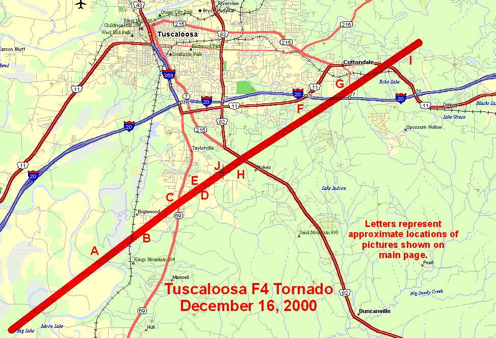 The tornado touched down just before 1:00 p.m. CDT near the Black Warrior River
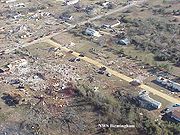
in southern Tuscaloosa County and proceeded northeastward for 18 miles (28.8 km) across the communities of Englewood, Hinton Place, Hillcrest Meadows, Bear Creek and Woodland Forest. A tornado emergency
was issued for the area before it lifted near Cottondale east of Tuscaloosa near Interstate 20
. At its peak intensity, the tornado was about 750 yards wide. The worst damage was located near the Bear Creek area where F4 damage occurred. Near I-20, several commercial buildings including hotels and restaurants were heavily damaged and a shopping center near Route 69 was also hit and partially destroyed. Damage was estimated at over $12 million US (2000 dollars). Over 40 houses and 70 mobile homes were completely destroyed with hundreds more seriously damaged.
 It was one of the deadliest tornadoes to hit the state since the Birmingham F5 tornado that killed 32 people across portions of northwestern Jefferson County
on April 8, 1998. That tornado started just northeast of Tuscaloosa during the evening hours demolishing numerous structures south and west of the Birmingham metro area. Since records have being kept in 1950, the Tuscaloosa tornado is the second deadliest tornado in December tied with an F4 tornado near Murphysboro, Illinois
in an outbreak on December 18, 1957, that included an F5 storm) and behind the Vicksburg, Mississippi
F5 tornado on December 5, 1953 which killed 38.
The 2000 Tuscaloosa tornado was part of a supercell
thunderstorm that developed across Mississippi
before traveling through western Alabama
, then near the Birmingham region before dropping more tornadoes in St. Clair
and Etowah
counties. Additional tornadoes were confirmed northwest of Birmingham and Jasper
.
The tornado was also captured live on the ABC
affiliate WBMA/WCFT/WJSU
(channels 58, 33 and 40, generally called "ABC 33/40") in Birmingham
during a special severe weather bulletin with meteorologists James Spann
, Mark Prater, and John Oldshue
. The tornado was caught by the station's tower cam located just outside downtown Tuscaloosa along Interstate 20/59
at Woodland Road on U.S. Highway 82. The National Academy of Television Arts and Sciences
gave Spann an Emmy Award
for the event. The tornado was followed from Englewood to just near its passage south of downtown Tuscaloosa when the reception was lost due to a torrential downpour.
and the Carolinas. A total of 24 tornadoes were reported on December 16, 2000. One more person was killed by a tornado in Geneva County
in southeastern Alabama.
Tuscaloosa, Alabama
Tuscaloosa is a city in and the seat of Tuscaloosa County in west central Alabama . Located on the Black Warrior River, it is the fifth-largest city in Alabama, with a population of 90,468 in 2010...
on December 16, 2000. The F4 rated tornado caused the deaths of 11 people while injuring over 125 others. It was the strongest tornado to hit the state of Alabama in the month of December since 1950 and the strongest of a moderate tornado outbreak
Tornado outbreak
While there is no single agreed upon definition, generally at least 6-10 tornadoes produced by the same synoptic scale weather system is considered a tornado outbreak. The tornadoes usually occur within the same day, or continue into the early morning hours of the succeeding day, and within the...
that took place across the Southeastern corner of the United States
United States
The United States of America is a federal constitutional republic comprising fifty states and a federal district...
from Mississippi to North Carolina
North Carolina
North Carolina is a state located in the southeastern United States. The state borders South Carolina and Georgia to the south, Tennessee to the west and Virginia to the north. North Carolina contains 100 counties. Its capital is Raleigh, and its largest city is Charlotte...
.
Tornado event
Black Warrior River
The Black Warrior River is a waterway in west central Alabama in the southeastern United States. The river rises in the extreme southern edges of the Appalachian Highlands and flows 178 miles to the Tombigbee River, of which the Black Warrior is the primary tributary...
in southern Tuscaloosa County and proceeded northeastward for 18 miles (28.8 km) across the communities of Englewood, Hinton Place, Hillcrest Meadows, Bear Creek and Woodland Forest. A tornado emergency
Tornado emergency
A Tornado Emergency is enhanced wording of tornado warnings used by the National Weather Service in the United States during significant tornado occurrences in highly populated areas...
was issued for the area before it lifted near Cottondale east of Tuscaloosa near Interstate 20
Interstate 20
Interstate 20 is a major east–west Interstate Highway in the Southern United States. I‑20 runs 1,535 miles from near Kent, Texas, at Interstate 10 to Florence, South Carolina, at Interstate 95...
. At its peak intensity, the tornado was about 750 yards wide. The worst damage was located near the Bear Creek area where F4 damage occurred. Near I-20, several commercial buildings including hotels and restaurants were heavily damaged and a shopping center near Route 69 was also hit and partially destroyed. Damage was estimated at over $12 million US (2000 dollars). Over 40 houses and 70 mobile homes were completely destroyed with hundreds more seriously damaged.
Jefferson County, Alabama
Jefferson County is the most populous county in the U.S. state of Alabama, with its county seat being located in Birmingham.As of the 2010 U.S. Census, the population of Jefferson County was 658,466...
on April 8, 1998. That tornado started just northeast of Tuscaloosa during the evening hours demolishing numerous structures south and west of the Birmingham metro area. Since records have being kept in 1950, the Tuscaloosa tornado is the second deadliest tornado in December tied with an F4 tornado near Murphysboro, Illinois
Murphysboro, Illinois
Murphysboro is a city in and the county seat of Jackson County, Illinois, United States. The population was 7,970 at the 2010 census. The city is part of the Metro Lakeland area.-Geography:Murphysboro is located at ....
in an outbreak on December 18, 1957, that included an F5 storm) and behind the Vicksburg, Mississippi
Vicksburg, Mississippi
Vicksburg is a city in Warren County, Mississippi, United States. It is the only city in Warren County. It is located northwest of New Orleans on the Mississippi and Yazoo rivers, and due west of Jackson, the state capital. In 1900, 14,834 people lived in Vicksburg; in 1910, 20,814; in 1920,...
F5 tornado on December 5, 1953 which killed 38.
The 2000 Tuscaloosa tornado was part of a supercell
Supercell
A supercell is a thunderstorm that is characterized by the presence of a mesocyclone: a deep, continuously-rotating updraft. For this reason, these storms are sometimes referred to as rotating thunderstorms...
thunderstorm that developed across Mississippi
Mississippi
Mississippi is a U.S. state located in the Southern United States. Jackson is the state capital and largest city. The name of the state derives from the Mississippi River, which flows along its western boundary, whose name comes from the Ojibwe word misi-ziibi...
before traveling through western Alabama
Alabama
Alabama is a state located in the southeastern region of the United States. It is bordered by Tennessee to the north, Georgia to the east, Florida and the Gulf of Mexico to the south, and Mississippi to the west. Alabama ranks 30th in total land area and ranks second in the size of its inland...
, then near the Birmingham region before dropping more tornadoes in St. Clair
St. Clair County, Alabama
St. Clair County is a county of the U.S. state of Alabama.It is a part of the Birmingham–Hoover–Cullman Combined Statistical Area. Its name is in honor of General Arthur St...
and Etowah
Etowah County, Alabama
Etowah County is a county of the U.S. state of Alabama. Its name is from the Cherokee language, which means "edible tree". It is the center of the Gadsden Metropolitan Area which includes Etowah and Cherokee Counties. As of 2010 the population was 104,430. Its county seat is Gadsden...
counties. Additional tornadoes were confirmed northwest of Birmingham and Jasper
Jasper, Alabama
Jasper is a city in Walker County, Alabama, United States. At the 2000 census the population was 14,659. As of 2011 the population had was 13,857. The city is the county seat of Walker County, and once ranked among the world's leading producers of coal....
.
Tower Cam tornado footage
| State | Total | County | County total |
|---|---|---|---|
| Alabama Alabama Alabama is a state located in the southeastern region of the United States. It is bordered by Tennessee to the north, Georgia to the east, Florida and the Gulf of Mexico to the south, and Mississippi to the west. Alabama ranks 30th in total land area and ranks second in the size of its inland... |
12 | Geneva Geneva County, Alabama -2010:Whereas according to the 2010 U.S. Census Bureau:*86.3% White*9.5% Black*0.8% Native American*0.3% Asian*0.0% Native Hawaiian or Pacific Islander*1.6% Two or more races*3.4% Hispanic or Latino -2000:... |
1 |
| Tuscaloosa Tuscaloosa County, Alabama Tuscaloosa County is a county of the U.S. state of Alabama.It is named in honor of the pre-Choctaw chief Tuskaloosa. In 2010, the population was 194,656... |
11 | ||
| Totals | 12 | ||
| All deaths were tornado-related | |||
The tornado was also captured live on the ABC
American Broadcasting Company
The American Broadcasting Company is an American commercial broadcasting television network. Created in 1943 from the former NBC Blue radio network, ABC is owned by The Walt Disney Company and is part of Disney-ABC Television Group. Its first broadcast on television was in 1948...
affiliate WBMA/WCFT/WJSU
WBMA-LP
WBMA-LD, channel 58, is the ABC television affiliate for Birmingham and central Alabama. Its transmitter is located in Birmingham, while its studio is in Hoover, a suburb of Birmingham....
(channels 58, 33 and 40, generally called "ABC 33/40") in Birmingham
Birmingham, Alabama
Birmingham is the largest city in Alabama. The city is the county seat of Jefferson County. According to the 2010 United States Census, Birmingham had a population of 212,237. The Birmingham-Hoover Metropolitan Area, in estimate by the U.S...
during a special severe weather bulletin with meteorologists James Spann
James Spann
James Spann is a television meteorologist based in Birmingham, Alabama. He currently works for ABC 33/40, whose studios are located in Hoover, Alabama but which has transmitters in Tuscaloosa and Anniston. Spann has worked in the field since 1978. -Career:Spann began his broadcast career in...
, Mark Prater, and John Oldshue
John Oldshue
John Oldshue was the weekend meteorologist and storm chaser for ABC 33/40 in Birmingham, Alabama from 1997 to 2007 when he retired to run a small business. He won an Emmy award for coverage of the Tuscaloosa tornado on December 16, 2000 with meteorologist James Spann...
. The tornado was caught by the station's tower cam located just outside downtown Tuscaloosa along Interstate 20/59
Interstate 59
Interstate 59 is an Interstate Highway in the southern United States. Its southern terminus is near Slidell, Louisiana, a suburb of New Orleans, at an intersection with Interstate 10 and Interstate 12, its northern terminus is at Wildwood, Georgia, at an intersection with Interstate 24.The road's...
at Woodland Road on U.S. Highway 82. The National Academy of Television Arts and Sciences
National Academy of Television Arts and Sciences
The National Academy of Television Arts & Sciences or NATAS was created in 1955 to advance the arts and sciences of television. Headquartered in New York, NATAS's membership is national and the organization has local chapters around the country....
gave Spann an Emmy Award
Emmy Award
An Emmy Award, often referred to simply as the Emmy, is a television production award, similar in nature to the Peabody Awards but more focused on entertainment, and is considered the television equivalent to the Academy Awards and the Grammy Awards .A majority of Emmys are presented in various...
for the event. The tornado was followed from Englewood to just near its passage south of downtown Tuscaloosa when the reception was lost due to a torrential downpour.
Other tornadoes
Additional tornadoes were reported during the day across the southeastern portion of the US, including in Mississippi, Georgia, TennesseeTennessee
Tennessee is a U.S. state located in the Southeastern United States. It has a population of 6,346,105, making it the nation's 17th-largest state by population, and covers , making it the 36th-largest by total land area...
and the Carolinas. A total of 24 tornadoes were reported on December 16, 2000. One more person was killed by a tornado in Geneva County
Geneva County, Alabama
-2010:Whereas according to the 2010 U.S. Census Bureau:*86.3% White*9.5% Black*0.8% Native American*0.3% Asian*0.0% Native Hawaiian or Pacific Islander*1.6% Two or more races*3.4% Hispanic or Latino -2000:...
in southeastern Alabama.
December 16, 2000
| F# Fujita scale The Fujita scale , or Fujita-Pearson scale, is a scale for rating tornado intensity, based primarily on the damage tornadoes inflict on human-built structures and vegetation... |
Location | County | Time (EDT) | Path length | Damage | |
|---|---|---|---|---|---|---|
| Alabama Alabama Alabama is a state located in the southeastern region of the United States. It is bordered by Tennessee to the north, Georgia to the east, Florida and the Gulf of Mexico to the south, and Mississippi to the west. Alabama ranks 30th in total land area and ranks second in the size of its inland... |
||||||
| F2 | NW of Geneva Geneva, Alabama Geneva is a city in and the county seat of Geneva County, Alabama, United States. It is part of the Dothan, Alabama Metropolitan Statistical Area. It is also the largest city of Geneva County, and has a population of 4,388 according to the 2000 census.... |
Geneva Geneva County, Alabama -2010:Whereas according to the 2010 U.S. Census Bureau:*86.3% White*9.5% Black*0.8% Native American*0.3% Asian*0.0% Native Hawaiian or Pacific Islander*1.6% Two or more races*3.4% Hispanic or Latino -2000:... |
1034 | 4.5 miles (7.2 km) | 1 death 100 homes were damaged and 5 mobile homes were destroyed including one with the fatality. 9 others were injured. | |
| F2 | N of Midland Midland City, Alabama Midland City is a town in Dale County, Alabama, United States. At the 2000 census the population was 1,703. This town is the location of Dothan Regional Airport. It is part of the Enterprise–Ozark Micropolitan Statistical Area.-Geography:... |
Houston Houston County, Alabama Houston County is a county of the U.S. state of Alabama. As of 2010 the population was 101,547. Its county seat is Dothan.Houston County is part of the Dothan Metropolitan Statistical Area.- History :... , Dale Dale County, Alabama Dale County is a county of the U.S. state of Alabama. Its name is in honor of General Samuel Dale. As of the 2010 census the population was 50,251... , Henry Henry County, Alabama Henry County is a county of the U.S. state of Alabama. Its name is in honor of Patrick Henry, famous orator and Governor of Virginia. As of 2010, its population was 17,302... |
1100 | 29 miles (46.4 km) | Several homes in Doe Run subdivision in Pinckard Pinckard, Alabama Pinckard is a town in Dale County, Alabama, United States. At the 2000 census the population was 667. It is part of the Enterprise–Ozark Micropolitan Statistical Area.-Geography:Pinckard is located at .According to the U.S... were destroyed. Several other homes and businesses were damaged to varying degrees as well as one church. |
|
| F1 | NW of Wheeler Lake | Lawrence Lawrence County, Alabama Lawrence County is a county of the U.S. state of Alabama, and is included in the Decatur Metropolitan Area, as well as the Huntsville-Decatur Combined Statistical Area. It was named after James Lawrence, a captain in the United States Navy from New Jersey. As of the 2010 census, the population was... , Limestone Limestone County, Alabama Limestone County is a county of the U.S. state of Alabama, and is included in the Huntsville Metropolitan Area.It is also included in the merged Huntsville-Decatur Metro Area. Its name comes from Limestone Creek, a local stream. In 2000, the population was 65,676. As of 2010 the county's... |
1225 | 5.1 miles (8.2 km) | Several outbuildings and boat houses were destroyed while three homes were damaged | |
| F2 | NW of Athens Athens, Alabama Athens is a city in Limestone County, Alabama, United States. As of the 2000 census, the population of the city is 18,967. According to the 2009 U.S. Census estimates, the city had a population of 24,234... |
Limestone Limestone County, Alabama Limestone County is a county of the U.S. state of Alabama, and is included in the Huntsville Metropolitan Area.It is also included in the merged Huntsville-Decatur Metro Area. Its name comes from Limestone Creek, a local stream. In 2000, the population was 65,676. As of 2010 the county's... |
1238 | 4.8 miles (7.7 km) | Three mobile homes were destroyed and several homes were heavily damaged | |
| F4 | S of Tuscaloosa Tuscaloosa, Alabama Tuscaloosa is a city in and the seat of Tuscaloosa County in west central Alabama . Located on the Black Warrior River, it is the fifth-largest city in Alabama, with a population of 90,468 in 2010... |
Tuscaloosa Tuscaloosa County, Alabama Tuscaloosa County is a county of the U.S. state of Alabama.It is named in honor of the pre-Choctaw chief Tuskaloosa. In 2010, the population was 194,656... |
1254 | 18 miles (28.8 km) | 11 deaths - Seen live on WCFT-TV WBMA-LP WBMA-LD, channel 58, is the ABC television affiliate for Birmingham and central Alabama. Its transmitter is located in Birmingham, while its studio is in Hoover, a suburb of Birmingham.... , tower camera. See this section |
|
| F0 | SE of Marion Marion, Alabama Marion is the county seat of Perry County, Alabama. As of the 2000 census, the population of the city is 3,511. First called Muckle Ridge, the city was renamed after a hero of the American Revolution, Francis Marion.-Geography:... |
Perry Perry County, Alabama Perry County is a county of the U.S. state of Alabama. It was established in 1819, and is named in honor of Commodore Oliver Hazard Perry of Rhode Island and the United States Navy. As of 2010 the population was 10,591... |
1329 | 0.7 mile (1.1 km) | Damage limited to trees | |
| F2 | S of Ashville Ashville, Alabama Ashville is a city in St. Clair County, Alabama, United States part of the Birmingham-Hoover-Cullman Combined Statistical Area. Its population was 2,260 at the 2000 census, at which time it was a town. This town is the county seat of St. Clair County along with Pell City. According to the 2005 U.S.... |
St. Clair St. Clair County, Alabama St. Clair County is a county of the U.S. state of Alabama.It is a part of the Birmingham–Hoover–Cullman Combined Statistical Area. Its name is in honor of General Arthur St... |
1420 | 8.5 miles (13.6 km) | Two mobile homes were destroyed and four homes were damaged | |
| F3 | NE of Gadsden Gadsden, Alabama The city of Gadsden is the county seat of Etowah County in the U.S. state of Alabama, and it is located about 65 miles northeast of Birmingham, Alabama. It is the primary city of the Gadsden Metropolitan Statistical Area, which has a population of 103,459. Gadsden is closely associated with the... |
Etowah Etowah County, Alabama Etowah County is a county of the U.S. state of Alabama. Its name is from the Cherokee language, which means "edible tree". It is the center of the Gadsden Metropolitan Area which includes Etowah and Cherokee Counties. As of 2010 the population was 104,430. Its county seat is Gadsden... , Cherokee Cherokee County, Alabama Cherokee County, Alabama is a county of the U.S. state of Alabama. It is named for the Cherokee tribe. As of 2010 the population was 25,989. Its county seat is Centre and it is a prohibition or dry county.- History :... |
1446 | 12.8 miles (20.5 km) | 250 homes were damaged or destroyed and 14 people were injured | |
| F0 | S of Bynum Bynum, Alabama Bynum is a former census-designated place in Calhoun County, Alabama, United States. At the 2000 census the population was 1,863. The area is now part of the city of Oxford and is included in the Anniston-Oxford, Alabama Metropolitan Statistical Area.... |
Calhoun Calhoun County, Alabama Calhoun County is a county in the U.S. state of Alabama. Its name is in honor of John C. Calhoun, famous member of the United States Senate from South Carolina. As of 2010 the population was 118,572. It is included in the Anniston-Oxford Metropolitan Statistical Area... |
1517 | 0.3 mile (0.5 km) | Brief tornado with no damage | |
| F0 | SW of Deatsville Deatsville, Alabama Deatsville is a town in Elmore County, Alabama, United States. Holtville High School is located near Deatsville.-Geography:Deatsville is located at .According to the U.S... |
Autauga Autauga County, Alabama Autauga County is a county in the U.S. state of Alabama. As of the 2010 census the population was 54,571. Its county seat is Prattville.Autauga County is part of the Montgomery Metropolitan Statistical Area.-History:... |
1655 | 0.2 mile (0.32 km) | Brief tornado with no damage | |
| F0 | S of Tallassee Tallassee, Alabama Tallassee is a city on the Tallapoosa River, located in both Elmore and Tallapoosa counties in the U.S. state of Alabama. At the 2000 census the population was 4,934... |
Macon Macon County, Alabama Macon County is a county in the U.S. state of Alabama. Its name is in honor of Nathaniel Macon, a member of the United States Senate from North Carolina. Developed for cotton plantation agriculture in the nineteenth century, it is one of the counties in Alabama within the Black Belt of the South.As... |
1746 | 0.7 mile (1.1 km) | Two outbuildings and two satellite dishes were destroyed while three homes had minor damage | |
| F0 | N of Roanoke Roanoke, Alabama Roanoke is a city in Randolph County, Alabama, United States.Roanoke is served by a weekly newspaper, The Randolph Leader. As of the 2000 census, the population of the city is 6,563.-Geography:Roanoke is located at .... |
Randolph Randolph County, Alabama Randolph County is a county of the U.S. state of Alabama.Its name is in honor of John Randolph, a member of the United States Senate from Virginia. As of 2010, the population was 22,913. Its county seat is Wedowee... |
1819 | 1 mile (1.6 km) | Damage limited to trees | |
| Mississippi Mississippi Mississippi is a U.S. state located in the Southern United States. Jackson is the state capital and largest city. The name of the state derives from the Mississippi River, which flows along its western boundary, whose name comes from the Ojibwe word misi-ziibi... |
||||||
| F2 | NE of Meridian Meridian, Mississippi Meridian is the county seat of Lauderdale County, Mississippi. It is the sixth largest city in the state and the principal city of the Meridian, Mississippi Micropolitan Statistical Area... |
Lauderdale Lauderdale County, Mississippi -Demographics:As of the census of 2000, there were 78,161 people, 29,990 households, and 20,573 families residing in the county. The population density was 111 people per square mile . There were 33,418 housing units at an average density of 48 per square mile... |
1130 | 12 miles (19.2 km) | Two homes, three businesses and three mobile homes were destroyed while 44 homes, 34 mobile homes and one business were also damaged. 17 injuries were reported, including one critical. | |
| Florida Florida Florida is a state in the southeastern United States, located on the nation's Atlantic and Gulf coasts. It is bordered to the west by the Gulf of Mexico, to the north by Alabama and Georgia and to the east by the Atlantic Ocean. With a population of 18,801,310 as measured by the 2010 census, it... |
||||||
| F0 | NE of Freeport Freeport, Florida Freeport is a city in Walton County, Florida, United States. The population was 1,190 at the 2000 census. As of 2004, the population recorded by the U.S. Census Bureau is 1,427.-Geography:Freeport is located at .... |
Walton Walton County, Florida Walton County is a county located in the state of Florida. As of 2000, the population was 40,601. The U.S. Census Bureau 2005 estimate for the county is 50,324. Its county seat is DeFuniak Springs, Florida. The county is home to the highest natural point in Florida: Britton Hill, at .- History... |
1255 | 0.2 mile (0.32 km) | Damage limited to trees | |
| F2 | SE of Bonifay Bonifay, Florida Bonifay is a city in Holmes County, Florida, United States. Bonifay was given its name from a prominent family that had a brick making factory in Pensacola, FL. Frank Bonifay, the man behind the town's name, bought a stake in the L%N, now CSX, Railroad. As W. D... |
Holmes Holmes County, Florida Holmes County is a county located in the U.S. state of Florida. As of 2000, the population was 18,564. The U.S. Census Bureau 2005 estimate for the county was 19,264 . Its county seat is Bonifay, Florida.-History:... |
1324 | 3 miles (4.8 km) | Four mobile homes were destroyed while 4 businesses and 39 homes were damaged | |
| F1 | SW of Campbellton Campbellton, Florida Campbellton is a town in Jackson County, Florida, United States. The population was 212 at the 2000 census.-Geography:Campbellton is located at .According to the United States Census Bureau, the town has a total area of... |
Jackson Jackson County, Florida Jackson County is a county located in the U.S. state of Florida. The population as of the 2000 census was 46,755. As of 2005, the population was estimated to be 48,985 . Its county seat is Marianna, Florida.- History :... |
1350 | 5 miles (8 km) | Damage to trees, carports and mobile homes | |
| Tennessee Tennessee Tennessee is a U.S. state located in the Southeastern United States. It has a population of 6,346,105, making it the nation's 17th-largest state by population, and covers , making it the 36th-largest by total land area... |
||||||
| F1 | NE of Ardmore Ardmore, Tennessee Ardmore is a city in Giles and Lincoln counties in the U.S. state of Tennessee. The population was 1,213 at the 2010 census. Ardmore is the site of a Tennessee Department of Tourist Development Welcome Center... |
Lincoln Lincoln County, Tennessee Lincoln County is a county located in the U.S. state of Tennessee. , the population was 31,340. Its county seat is Fayetteville. It is named for Major General Benjamin Lincoln, an officer in the American Revolutionary War.-History:... |
1308 | 1.5 miles (2.4 km) | One outbuilding was destroyed, one mobile home was heavily damaged and the roof of a cinder block garage was turned about 90 degrees | |
| Georgia | ||||||
| F2 | N of Albany Albany, Georgia Albany is a city in and the county seat of Dougherty County, Georgia, United States, in the southwestern part of the state. It is the principal city of the Albany, Georgia metropolitan area and the southwest part of the state. The population was 77,434 at the 2010 U.S. Census, making it the... |
Dougherty Dougherty County, Georgia Dougherty County is a county located in the U.S. state of Georgia. As of 2000, the population was 96,065. The 2009 Census Estimate shows a population of 95,859. It is included in the Albany, Georgia Metropolitan Statistical Area... |
1550 | 6 miles (9.6 km) | Abigail Plantation was heavily affected with several structures damaged while a few homes were also damaged. Storage buildings at a trailer park were also damaged | |
| F2 | SE of Americus Americus, Georgia -Early years:Americus, Georgia was named and chartered by Sen. Lovett B. Smith in 1832.For its first two decades, Americus was a small courthouse town. The arrival of the railroad in 1854 and, three decades later, local attorney Samuel H. Hawkins' construction of the only privately financed... |
Sumter Sumter County, Georgia Sumter County is a county located in the southwest portion of the U.S. state of Georgia. It was created on December 26, 1831. As of 2000, the population was 33,200. The 2007 Census Estimate shows a population of 32,532... |
2030 | 10 miles (16 km) | A frame house, three barns, several chicken houses and five outbuildings were destroyed. 400 chickens and two cattle were killed. One camper trailer was overturned and one home was damaged. | |
| F2 | S of Augusta Augusta, Georgia Augusta is a consolidated city in the U.S. state of Georgia, located along the Savannah River. As of the 2010 census, the Augusta–Richmond County population was 195,844 not counting the unconsolidated cities of Hephzibah and Blythe.Augusta is the principal city of the Augusta-Richmond County... |
Richmond Richmond County, Georgia Richmond County is a county located in the U.S. state of Georgia. It is one of the original counties of Georgia, created February 5, 1777. As of 2010, the population was 200,549. The 2007 Census Estimate showed a population of 199,486.... |
2310 | 2 miles (3.2 km) | 8 people were injured as the tornado did extensive damage to a subdivision south of Augusta | |
| South Carolina South Carolina South Carolina is a state in the Deep South of the United States that borders Georgia to the south, North Carolina to the north, and the Atlantic Ocean to the east. Originally part of the Province of Carolina, the Province of South Carolina was one of the 13 colonies that declared independence... |
||||||
| F0 | NW of Calhoun Falls Calhoun Falls, South Carolina Calhoun Falls is a town in Abbeville County, South Carolina, United States. The population was 2,303 at the 2000 census.The Calhoun Falls State Recreation Area is located nearby. Lake Richard B. Russell, which straddles the Georgia-South Carolina border, is approximately 3 miles west of Calhoun... |
Abbeville Abbeville County, South Carolina Abbeville County is a county located in the U.S. state of South Carolina. In 2010, its population was 25,147. Its county seat is Abbeville. It is the first county in the United States alphabetically.-History:... |
2110 | 0.1 mile (0.16 km) | A satellite dish was torn off a house | |
| North Carolina North Carolina North Carolina is a state located in the southeastern United States. The state borders South Carolina and Georgia to the south, Tennessee to the west and Virginia to the north. North Carolina contains 100 counties. Its capital is Raleigh, and its largest city is Charlotte... |
||||||
| F0 | W of Spring Lake Spring Lake, North Carolina Spring Lake is a town in Cumberland County, North Carolina, United States. The 2010 census recorded the population at 11,964 people.- History :... |
Cumberland Cumberland County, North Carolina -Demographics:As of the census of 2000, there were 302,963 people, 107,358 households, and 77,619 families residing in the county. The population density was 464 people per square mile . There were 118,425 housing units at an average density of 181 per square mile... |
2300 | 0.1 mile (0.16 km) | Brief tornado with no damage | |
| F0 | SW of Lillington Lillington, North Carolina Lillington is a town in Harnett County, North Carolina, United States. The population was 2,915 at the 2000 census. It is the county seat of Harnett County.-Geography:Lillington is located at .... |
Harnett Harnett County, North Carolina -Demographics:As of the census of 2000, there were 91,025 people, 33,800 households, and 24,099 families residing in the county. The population density was 153 people per square mile . There were 38,605 housing units at an average density of 65 per square mile... |
2310 | 0.1 mile (0.16 km) | Some buildings had windows blown off. | |
| F0 | N of Coats Coats, North Carolina Coats is a town in Harnett County, North Carolina, United States. The population was 1,845 at the 2000 census.-Geography:Coats is located at .... |
Harnett Harnett County, North Carolina -Demographics:As of the census of 2000, there were 91,025 people, 33,800 households, and 24,099 families residing in the county. The population density was 153 people per square mile . There were 38,605 housing units at an average density of 65 per square mile... |
2315 | 0.1 mile (0.16 km) | Damage limited to trees and smashed car windows | |
| Sources: Storm Data, December 16, 2000 (Tornado History Project) | ||||||