

Turfan Depression
Encyclopedia
The Turpan Depression or Turfan Depression is a fault-bounded trough located around and south of the city-oasis
of Turpan, in the Xinjiang
Autonomous Region in far western China
, about 150 km southeast of the provincial capital Ürümqi
. It includes the third lowest exposed point on the Earth
's surface (dry Lake Ayding, -154m), after the Dead Sea
and Lake Assal (Djibouti). It is entirely below sea level
. By some measures, it is also the hottest and driest area in China.
. It covers an area of 50,000 km². The surrounding mountain ranges are: the central Tian Shan in the west, the Bogda Shan
in the north-west, the Haerlike Shan in the north-west, and the Jueluotage Shan in the south. Beyond the surrounding mountain ranges lie the Junggar Basin in the north and the Tarim Basin
in the south.
Some geographers also use the term Turpan-Hami Basin, which is understood as including the Turpan Depression along with the Hami Depression (located to the east of the Turpan Depression, and to the southwest of the city of Hami) and the Liaodong Uplift separating the two depressions. A source using this terminology gave the area of the Turpan Depression proper as 28,600 km², that of the Hami Depression as 19,300 km², and for the entire Turpan-Hami Basin, as 48,000 km².
The Turpan Basin formed in a shear zone
during the Late Permian
due to motion between the East European and the Angaran craton
. It was subsequently deformed by the collision of the Indian and Eurasian plates in the Cenozoic
. In the latter deformation, a thrust fault belt running from east to west, the Flaming Mountains
, was formed in the center of the basin. The Flaming Mountains are 98 km long and 9 km wide; the highest peak reaches an elevation of 831.7 m above sea level.
Also in the center of the basin lies the Ayding Lake (Moonlight Lake) which has an elevation of 154.5 m below sea level (see the list of places on land with elevations below sea level). Its shores mark the third lowest exposed elevation on the Earth's land surface (after the Dead Sea
which reaches down to more than 400 meters below sea level, and Lake Assal (Djibouti) at 155 m below sea level). It is the lowest surface point in China.
The Shihongtan uranium
ore deposit is located at the southwestern margin of the Turpan Depression, some 35 km south-southwest from Turpan city.
, collected between 1951 and 1990 from the Turpan weather station). In contrast to this, the potential annual evaporation rate reaches 3 m. Because of its climate, the area is sometimes counted as one of the Furnaces of China, although the locations included under this heading vary.
 On the shores of Aydingkol Lake, reeds, tamarisks
, saxaul
s, as well as other shrubs and weeds can be found. Away from sources of water, the Turpan Basin is not covered by vegetation. Consequently, agriculture is limited to oasis and depends on a sophisticated irrigation system known as the Karez System. The irrigation water comes from the surrounding mountain ranges, in particular from the annual melting of the snow. The Karez System consists of wells, underground channels, ground canals, and small reservoirs, which use the natural slope of the terrain to sustain the water flow and guide the water right to the plants while minimizing evaporation all along the way. The historical record of the system extends back to the Han Dynasty
. The number of Karez systems in the area is slightly below 1,000 and the total length of the canals is about 5,000 km in length. The Karez System is therefore considered as one of the three great ancient projects in China along with the Great Wall and the Grand Canal
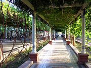
. Farming in the Turpan Basin is particularly famous for its fruit. Because of the dry and hot conditions, the fruits grown in the depression have very high concentrations of sugar. They are traditionally processed by drying in open drying barns. The cultivated fruit include: mulberry
, peach
, apricot
, apple
, pomegranate
, pear
, fig
, walnut
, as well as grape
s, watermelon
s and muskmelon
s. Among the fruit, the grapes stand out: more than 100 varieties of grape are cultivated in the area and it accounts for 90% of China's seedless grape crop. Other specialty agricultural products of the region are Donghu Hami melons and long-staple cotton.
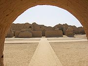 The ancient city of Gaochang
was a key point on the ancient Silk Road
and dates back to the 1st century BC. It was burnt down in wars in the 14th century. The Bezeklik Thousand Buddha Caves
, which are located in the Flaming Mountains
' Mutou Valley
, about 30 km (18.6 mi) east of the city of Turpan, have been hewn into the rock from the Tang Dynasty
era up to the time of the Yuan Dynasty
(13th century). The caves are famous for their murals, which can still be found in about 40 of the 77 known caves. The desert climate has favored preservation of the content of the Astana-Karakhoja ancient tombs
, which are located about 6 km from the ancient city of Gaochang. The tombs are the burial place for nobles, officials, and others who were interred there from the times of the Western Jin Dynasty until the middle of the Tang Dynasty
era.
Oasis
In geography, an oasis or cienega is an isolated area of vegetation in a desert, typically surrounding a spring or similar water source...
of Turpan, in the Xinjiang
Xinjiang
Xinjiang is an autonomous region of the People's Republic of China. It is the largest Chinese administrative division and spans over 1.6 million km2...
Autonomous Region in far western China
China
Chinese civilization may refer to:* China for more general discussion of the country.* Chinese culture* Greater China, the transnational community of ethnic Chinese.* History of China* Sinosphere, the area historically affected by Chinese culture...
, about 150 km southeast of the provincial capital Ürümqi
Ürümqi
Ürümqi , formerly Tihwa , is the capital of Xinjiang Uyghur Autonomous Region of the People's Republic of China, in the northwest of the country....
. It includes the third lowest exposed point on the Earth
Earth
Earth is the third planet from the Sun, and the densest and fifth-largest of the eight planets in the Solar System. It is also the largest of the Solar System's four terrestrial planets...
's surface (dry Lake Ayding, -154m), after the Dead Sea
Dead Sea
The Dead Sea , also called the Salt Sea, is a salt lake bordering Jordan to the east and Israel and the West Bank to the west. Its surface and shores are below sea level, the lowest elevation on the Earth's surface. The Dead Sea is deep, the deepest hypersaline lake in the world...
and Lake Assal (Djibouti). It is entirely below sea level
Sea level
Mean sea level is a measure of the average height of the ocean's surface ; used as a standard in reckoning land elevation...
. By some measures, it is also the hottest and driest area in China.
Geology and relief
The Turpan Basin is a fault-bounded trough located in the eastern part of the Tian ShanTian Shan
The Tian Shan , also spelled Tien Shan, is a large mountain system located in Central Asia. The highest peak in the Tian Shan is Victory Peak , ....
. It covers an area of 50,000 km². The surrounding mountain ranges are: the central Tian Shan in the west, the Bogda Shan
Bogda Shan
The Bogda Shan range is part of the eastern Tien Shan mountains, and located in Xinjiang, some 60 km east of Ürümqi. The highest elevation is Bogda Feng, at 5445 m....
in the north-west, the Haerlike Shan in the north-west, and the Jueluotage Shan in the south. Beyond the surrounding mountain ranges lie the Junggar Basin in the north and the Tarim Basin
Tarim Basin
The Tarim Basin is a large endorheic basin occupying an area of about . It is located in the Xinjiang Uyghur Autonomous Region in China's far west. Its northern boundary is the Tian Shan mountain range and its southern is the Kunlun Mountains on the northern edge of the Tibetan Plateau. The...
in the south.
Some geographers also use the term Turpan-Hami Basin, which is understood as including the Turpan Depression along with the Hami Depression (located to the east of the Turpan Depression, and to the southwest of the city of Hami) and the Liaodong Uplift separating the two depressions. A source using this terminology gave the area of the Turpan Depression proper as 28,600 km², that of the Hami Depression as 19,300 km², and for the entire Turpan-Hami Basin, as 48,000 km².
The Turpan Basin formed in a shear zone
Shear zone
A shear zone is a very important structural discontinuity surface in the Earth's crust and upper mantle. It forms as a response to inhomogeneous deformation partitioning strain into planar or curviplanar high-strain zones. Intervening blocks stay relatively unaffected by the deformation...
during the Late Permian
Permian
The PermianThe term "Permian" was introduced into geology in 1841 by Sir Sir R. I. Murchison, president of the Geological Society of London, who identified typical strata in extensive Russian explorations undertaken with Edouard de Verneuil; Murchison asserted in 1841 that he named his "Permian...
due to motion between the East European and the Angaran craton
Craton
A craton is an old and stable part of the continental lithosphere. Having often survived cycles of merging and rifting of continents, cratons are generally found in the interiors of tectonic plates. They are characteristically composed of ancient crystalline basement rock, which may be covered by...
. It was subsequently deformed by the collision of the Indian and Eurasian plates in the Cenozoic
Cenozoic
The Cenozoic era is the current and most recent of the three Phanerozoic geological eras and covers the period from 65.5 mya to the present. The era began in the wake of the Cretaceous–Tertiary extinction event at the end of the Cretaceous that saw the demise of the last non-avian dinosaurs and...
. In the latter deformation, a thrust fault belt running from east to west, the Flaming Mountains
Flaming Mountains
The Flaming Mountains or Gaochang Mountains are barren, eroded, red sandstone hills in Tian Shan Mountain range, Xinjiang, China. They lie near the northern rim of the Taklamakan Desert and east of the city of Turpan...
, was formed in the center of the basin. The Flaming Mountains are 98 km long and 9 km wide; the highest peak reaches an elevation of 831.7 m above sea level.
Also in the center of the basin lies the Ayding Lake (Moonlight Lake) which has an elevation of 154.5 m below sea level (see the list of places on land with elevations below sea level). Its shores mark the third lowest exposed elevation on the Earth's land surface (after the Dead Sea
Dead Sea
The Dead Sea , also called the Salt Sea, is a salt lake bordering Jordan to the east and Israel and the West Bank to the west. Its surface and shores are below sea level, the lowest elevation on the Earth's surface. The Dead Sea is deep, the deepest hypersaline lake in the world...
which reaches down to more than 400 meters below sea level, and Lake Assal (Djibouti) at 155 m below sea level). It is the lowest surface point in China.
The Shihongtan uranium
Uranium
Uranium is a silvery-white metallic chemical element in the actinide series of the periodic table, with atomic number 92. It is assigned the chemical symbol U. A uranium atom has 92 protons and 92 electrons, of which 6 are valence electrons...
ore deposit is located at the southwestern margin of the Turpan Depression, some 35 km south-southwest from Turpan city.
Climate
The Turpan Basin has a hot and arid continental climate in which the precipitation is far less than the potential evaporation. July is the hottest month with an average maximum temperature of 39.7°C (103.5°F) and January the coolest with an average maximum temperature of -2.2°C (28°F). Monthly rainfall is highest in June (3.3 mm) and lowest in February (0.2 mm). The annual average precipitation is less than 2 cm (data from the Global Historical Climatology NetworkGlobal Historical Climatology Network
The Global Historical Climatology Network is a database of temperature, precipitation and pressure records managed by the National Climatic Data Center, Arizona State University and the Carbon Dioxide Information Analysis Center....
, collected between 1951 and 1990 from the Turpan weather station). In contrast to this, the potential annual evaporation rate reaches 3 m. Because of its climate, the area is sometimes counted as one of the Furnaces of China, although the locations included under this heading vary.
Vegetation and agriculture
Tamarix
The genus Tamarix is composed of about 50-60 species of flowering plants in the family Tamaricaceae, native to drier areas of Eurasia and Africa...
, saxaul
Saxaul
The saxaul, black saxaul, sometimes sacsaoul or saksaul , is a plant belonging to the Amaranthaceae.-Description:The saxaul ranges in size from a large shrub to a small tree, 2-8 m tall. It has a brown trunk 4-10 cm in diameter. The wood is heavy and coarse and the bark is spongy and water-soaked...
s, as well as other shrubs and weeds can be found. Away from sources of water, the Turpan Basin is not covered by vegetation. Consequently, agriculture is limited to oasis and depends on a sophisticated irrigation system known as the Karez System. The irrigation water comes from the surrounding mountain ranges, in particular from the annual melting of the snow. The Karez System consists of wells, underground channels, ground canals, and small reservoirs, which use the natural slope of the terrain to sustain the water flow and guide the water right to the plants while minimizing evaporation all along the way. The historical record of the system extends back to the Han Dynasty
Han Dynasty
The Han Dynasty was the second imperial dynasty of China, preceded by the Qin Dynasty and succeeded by the Three Kingdoms . It was founded by the rebel leader Liu Bang, known posthumously as Emperor Gaozu of Han. It was briefly interrupted by the Xin Dynasty of the former regent Wang Mang...
. The number of Karez systems in the area is slightly below 1,000 and the total length of the canals is about 5,000 km in length. The Karez System is therefore considered as one of the three great ancient projects in China along with the Great Wall and the Grand Canal
Grand Canal of China
The Grand Canal in China, also known as the Beijing-Hangzhou Grand Canal is the longest canal or artificial river in the world. Starting at Beijing, it passes through Tianjin and the provinces of Hebei, Shandong, Jiangsu and Zhejiang to the city of Hangzhou...
. Farming in the Turpan Basin is particularly famous for its fruit. Because of the dry and hot conditions, the fruits grown in the depression have very high concentrations of sugar. They are traditionally processed by drying in open drying barns. The cultivated fruit include: mulberry
Mulberry
Morus is a genus of flowering plants in the family Moraceae. The 10–16 species of deciduous trees it contains are commonly known as Mulberries....
, peach
Peach
The peach tree is a deciduous tree growing to tall and 6 in. in diameter, belonging to the subfamily Prunoideae of the family Rosaceae. It bears an edible juicy fruit called a peach...
, apricot
Apricot
The apricot, Prunus armeniaca, is a species of Prunus, classified with the plum in the subgenus Prunus. The native range is somewhat uncertain due to its extensive prehistoric cultivation.- Description :...
, apple
Apple
The apple is the pomaceous fruit of the apple tree, species Malus domestica in the rose family . It is one of the most widely cultivated tree fruits, and the most widely known of the many members of genus Malus that are used by humans. Apple grow on small, deciduous trees that blossom in the spring...
, pomegranate
Pomegranate
The pomegranate , Punica granatum, is a fruit-bearing deciduous shrub or small tree growing between five and eight meters tall.Native to the area of modern day Iran, the pomegranate has been cultivated in the Caucasus since ancient times. From there it spread to Asian areas such as the Caucasus as...
, pear
Pear
The pear is any of several tree species of genus Pyrus and also the name of the pomaceous fruit of these trees. Several species of pear are valued by humans for their edible fruit, but the fruit of other species is small, hard, and astringent....
, fig
Ficus
Ficus is a genus of about 850 species of woody trees, shrubs, vines, epiphytes, and hemiepiphyte in the family Moraceae. Collectively known as fig trees or figs, they are native throughout the tropics with a few species extending into the semi-warm temperate zone. The Common Fig Ficus is a genus of...
, walnut
Walnut
Juglans is a plant genus of the family Juglandaceae, the seeds of which are known as walnuts. They are deciduous trees, 10–40 meters tall , with pinnate leaves 200–900 millimetres long , with 5–25 leaflets; the shoots have chambered pith, a character shared with the wingnuts , but not the hickories...
, as well as grape
Grape
A grape is a non-climacteric fruit, specifically a berry, that grows on the perennial and deciduous woody vines of the genus Vitis. Grapes can be eaten raw or they can be used for making jam, juice, jelly, vinegar, wine, grape seed extracts, raisins, molasses and grape seed oil. Grapes are also...
s, watermelon
Watermelon
Watermelon is a vine-like flowering plant originally from southern Africa. Its fruit, which is also called watermelon, is a special kind referred to by botanists as a pepo, a berry which has a thick rind and fleshy center...
s and muskmelon
Muskmelon
Muskmelon is a species of melon that has been developed into many cultivated varieties. These include smooth skinned varieties such as honeydew, crenshaw and casaba, and different netted cultivars...
s. Among the fruit, the grapes stand out: more than 100 varieties of grape are cultivated in the area and it accounts for 90% of China's seedless grape crop. Other specialty agricultural products of the region are Donghu Hami melons and long-staple cotton.
History
Gaochang
Gaochang is the site of an ancient oasis city built on the northern rim of the inhospitable Taklamakan Desert in Xinjiang, China. A busy trading center, it was a stopping point for merchant traders traveling on the Silk Road...
was a key point on the ancient Silk Road
Silk Road
The Silk Road or Silk Route refers to a historical network of interlinking trade routes across the Afro-Eurasian landmass that connected East, South, and Western Asia with the Mediterranean and European world, as well as parts of North and East Africa...
and dates back to the 1st century BC. It was burnt down in wars in the 14th century. The Bezeklik Thousand Buddha Caves
Bezeklik Thousand Buddha Caves
The Bezeklik Thousand Buddha Caves are complex of Buddhist cave grottos dating from the 5th to the 9th centuries between the cities of Turpan and Shanshan at the north-east of the Taklamakan Desert near the ancient ruins of Gaochang in the Mutou Valley, a gorge in the Flaming Mountains, China...
, which are located in the Flaming Mountains
Flaming Mountains
The Flaming Mountains or Gaochang Mountains are barren, eroded, red sandstone hills in Tian Shan Mountain range, Xinjiang, China. They lie near the northern rim of the Taklamakan Desert and east of the city of Turpan...
' Mutou Valley
Mutou Valley
Mutou Valley is located in the Flaming Mountains, near the ancient oasis city of Gaochang on the rim of the Taklamakan Desert in the Xinjiang Autonomous Region, China. Under a cliff in the Mutou Valley is located the Bezeklik Thousand Buddha Caves, a complex of Buddhist caves temples dating from...
, about 30 km (18.6 mi) east of the city of Turpan, have been hewn into the rock from the Tang Dynasty
Tang Dynasty
The Tang Dynasty was an imperial dynasty of China preceded by the Sui Dynasty and followed by the Five Dynasties and Ten Kingdoms Period. It was founded by the Li family, who seized power during the decline and collapse of the Sui Empire...
era up to the time of the Yuan Dynasty
Yuan Dynasty
The Yuan Dynasty , or Great Yuan Empire was a ruling dynasty founded by the Mongol leader Kublai Khan, who ruled most of present-day China, all of modern Mongolia and its surrounding areas, lasting officially from 1271 to 1368. It is considered both as a division of the Mongol Empire and as an...
(13th century). The caves are famous for their murals, which can still be found in about 40 of the 77 known caves. The desert climate has favored preservation of the content of the Astana-Karakhoja ancient tombs
Astana Graves
The Astana Graves are a series of underground tombs located 6km from the ancient city of Gaochang, and 42km from Turpan, in Xinjiang, China. The tombs were used by the inhabitants of Gaochang, both commoners and locals, for about 600 years from 200 CE – 800 CE. The complex covers 10 square...
, which are located about 6 km from the ancient city of Gaochang. The tombs are the burial place for nobles, officials, and others who were interred there from the times of the Western Jin Dynasty until the middle of the Tang Dynasty
Tang Dynasty
The Tang Dynasty was an imperial dynasty of China preceded by the Sui Dynasty and followed by the Five Dynasties and Ten Kingdoms Period. It was founded by the Li family, who seized power during the decline and collapse of the Sui Empire...
era.
Sources
- Shao Leia, Karl Statteggerb, Wenhou LI, and Bernd J. Haupt (1999), "Depositional style and subsidence history of the Turpan Basin (NW China)", Sedimentary Geology, Vol. 128, No. 1-2, pp. 155–169
- Allen MB, AMC Scedilengör, BA Natal'in (1995), "Junggar, Turpan and Alakol basins as Late Permian to ?Early Triassic extensional structures in a sinistral shear zone in the Altaid orogenic collage, Central Asia", Journal of the Geological Society, Vol. 152, No. 2, pp. 327–338