

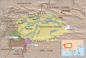
Tarim Basin
Encyclopedia
People's Republic of China
China , officially the People's Republic of China , is the most populous country in the world, with over 1.3 billion citizens. Located in East Asia, the country covers approximately 9.6 million square kilometres...
's far west. Its northern boundary is the Tian Shan
Tian Shan
The Tian Shan , also spelled Tien Shan, is a large mountain system located in Central Asia. The highest peak in the Tian Shan is Victory Peak , ....
mountain range and its southern is the Kunlun Mountains
Kunlun Mountains
The Kunlun Mountains are one of the longest mountain chains in Asia, extending more than 3,000 km. In the broadest sense, it forms the northern edge of the Tibetan Plateau south of the Tarim Basin and the Gansu Corridor and continues east south of the Wei River to end at the North China Plain.The...
on the northern edge of the Tibetan Plateau
Tibetan Plateau
The Tibetan Plateau , also known as the Qinghai–Tibetan Plateau is a vast, elevated plateau in Central Asia covering most of the Tibet Autonomous Region and Qinghai, in addition to smaller portions of western Sichuan, southwestern Gansu, and northern Yunnan in Western China and Ladakh in...
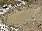
. The Taklamakan Desert dominates much of the basin. The area is sparsely settled by the Uyghur
Uyghur people
The Uyghur are a Turkic ethnic group living in Eastern and Central Asia. Today, Uyghurs live primarily in the Xinjiang Uyghur Autonomous Region in the People's Republic of China...
s, other Turkic peoples
Turkic peoples
The Turkic peoples are peoples residing in northern, central and western Asia, southern Siberia and northwestern China and parts of eastern Europe. They speak languages belonging to the Turkic language family. They share, to varying degrees, certain cultural traits and historical backgrounds...
and Tajiks.
Geology
The Tarim Basin is the result of an amalgamation between an ancient microcontinent and the growing Eurasian continent during the CarboniferousCarboniferous
The Carboniferous is a geologic period and system that extends from the end of the Devonian Period, about 359.2 ± 2.5 Mya , to the beginning of the Permian Period, about 299.0 ± 0.8 Mya . The name is derived from the Latin word for coal, carbo. Carboniferous means "coal-bearing"...
to Permian
Permian
The PermianThe term "Permian" was introduced into geology in 1841 by Sir Sir R. I. Murchison, president of the Geological Society of London, who identified typical strata in extensive Russian explorations undertaken with Edouard de Verneuil; Murchison asserted in 1841 that he named his "Permian...
periods. At present, deformation around the margins of the basin is resulting in the microcontinental crust being pushed under Tian Shan to the north, and Kunlun Shan to the south.
A thick succession of Paleozoic
Paleozoic
The Paleozoic era is the earliest of three geologic eras of the Phanerozoic eon, spanning from roughly...
, Mesozoic
Mesozoic
The Mesozoic era is an interval of geological time from about 250 million years ago to about 65 million years ago. It is often referred to as the age of reptiles because reptiles, namely dinosaurs, were the dominant terrestrial and marine vertebrates of the time...
and Cenozoic
Cenozoic
The Cenozoic era is the current and most recent of the three Phanerozoic geological eras and covers the period from 65.5 mya to the present. The era began in the wake of the Cretaceous–Tertiary extinction event at the end of the Cretaceous that saw the demise of the last non-avian dinosaurs and...
rocks occupy the central parts of the basin, locally exceeding thicknesses of 15 km (9.3 mi). The source rock
Source rock
In petroleum geology, source rock refers to rocks from which hydrocarbons have been generated or are capable of being generated. They form one of the necessary elements of a working petroleum system. They are organic-rich sediments that may have been deposited in a variety of environments including...
s of oil and gas tend to be Permian
Permian
The PermianThe term "Permian" was introduced into geology in 1841 by Sir Sir R. I. Murchison, president of the Geological Society of London, who identified typical strata in extensive Russian explorations undertaken with Edouard de Verneuil; Murchison asserted in 1841 that he named his "Permian...
mudstones. Below this level is a complex Precambrian basement believed to be made up of the remnants of the original Tarim microplate, which accrued to the growing Eurasia
Eurasia
Eurasia is a continent or supercontinent comprising the traditional continents of Europe and Asia ; covering about 52,990,000 km2 or about 10.6% of the Earth's surface located primarily in the eastern and northern hemispheres...
n continent in Carboniferous
Carboniferous
The Carboniferous is a geologic period and system that extends from the end of the Devonian Period, about 359.2 ± 2.5 Mya , to the beginning of the Permian Period, about 299.0 ± 0.8 Mya . The name is derived from the Latin word for coal, carbo. Carboniferous means "coal-bearing"...
time.
The snow on K2
K2
K2 is the second-highest mountain on Earth, after Mount Everest...
, the second highest mountain in the world, flows into glacier
Glacier
A glacier is a large persistent body of ice that forms where the accumulation of snow exceeds its ablation over many years, often centuries. At least 0.1 km² in area and 50 m thick, but often much larger, a glacier slowly deforms and flows due to stresses induced by its weight...
s which move down the valleys to melt. The melted water forms rivers which flow down the mountains and into the Tarim Basin, never reaching the sea. Surrounded by desert, some rivers feed the oases where the water is used for irrigation while others flow to salt lakes and marshes.
Lop Nur
Lop Nur
Lop Lake or Lop Nur is a group of small, now seasonal salt lake sand marshes between the Taklamakan and Kuruktag deserts in the Bayingolin Mongol Autonomous Prefecture, southeastern portion of Xinjiang Uygur Autonomous Region in the People's Republic of China.The lake system into which the Tarim...
is a marsh
Marsh
In geography, a marsh, or morass, is a type of wetland that is subject to frequent or continuous flood. Typically the water is shallow and features grasses, rushes, reeds, typhas, sedges, other herbaceous plants, and moss....
y, saline depression at the east end of the Tarim Basin. The Tarim River
Tarim River
The Tarim River is the principal river of the Xinjiang Uygur Autonomous Region in the People's Republic of China...
ends in Lop Nur.
The Tarim Basin is believed to contain large potential reserves of petroleum
Petroleum
Petroleum or crude oil is a naturally occurring, flammable liquid consisting of a complex mixture of hydrocarbons of various molecular weights and other liquid organic compounds, that are found in geologic formations beneath the Earth's surface. Petroleum is recovered mostly through oil drilling...
and natural gas
Natural gas
Natural gas is a naturally occurring gas mixture consisting primarily of methane, typically with 0–20% higher hydrocarbons . It is found associated with other hydrocarbon fuel, in coal beds, as methane clathrates, and is an important fuel source and a major feedstock for fertilizers.Most natural...
. Methane
Methane
Methane is a chemical compound with the chemical formula . It is the simplest alkane, the principal component of natural gas, and probably the most abundant organic compound on earth. The relative abundance of methane makes it an attractive fuel...
comprises over 70 percent of the natural gas reserve, with variable contents of ethane (<1% ~18%) and propane (<0.5% ~9%). China National Petroleum Corporation
China National Petroleum Corporation
China National Petroleum Corporation is a state-owned fuel-producing corporation and the largest integrated oil and gas company in the People's Republic of China...
's comprehensive exploration of the Tarim basin between 1989 and 1995 led to the identification of 26 oil- and gas-bearing structures. These occur at deeper depths and in scattered deposits. Beijing aims to develop Xinjiang
Xinjiang
Xinjiang is an autonomous region of the People's Republic of China. It is the largest Chinese administrative division and spans over 1.6 million km2...
into China's new energy base for the long run, supplying one-fifth of the country's total oil supply by 2010, with an annual output of 35 million tonne
Tonne
The tonne, known as the metric ton in the US , often put pleonastically as "metric tonne" to avoid confusion with ton, is a metric system unit of mass equal to 1000 kilograms. The tonne is not an International System of Units unit, but is accepted for use with the SI...
s. On June 10, 2010 Baker Hughes
Baker Hughes
Baker Hughes Baker Hughes provides the world's oil & gas industry with products and services for drilling, formation evaluation, completion, production and reservoir consulting. Baker Hughes operates in over 90 countries worldwide mainly based in countries with a mature petroleum industry as is...
announced an agreement to work with PetroChina Tarim Oilfield Co.
PetroChina
PetroChina Company Limited is a Chinese oil company and is the listed arm of state-owned China National Petroleum Corporation , headquartered in Dongcheng District, Beijing. It is China's biggest oil producer, and was the world's most valuable company by market value as of September 28th 2010...
to supply oilfield services, including both directional
Directional drilling
Directional drilling is the practice of drilling non-vertical wells. It can be broken down into three main groups: Oilfield Directional Drilling, Utility Installation Directional Drilling Directional drilling (or slant drilling) is the practice of drilling non-vertical wells. It can be broken down...
and vertical drilling systems, formation evaluation
Formation evaluation
In petroleum exploration and development, formation evaluation is used to determine the ability of a borehole to produce petroleum. Essentially, it is the process of "recognizing a commercial well when you drill one"....
services, completion systems and artificial lift
Artificial lift
Artificial lift refers to the use of artificial means to increase the flow of liquids, such as crude oil or water, from a production well. Generally this is achieved by the use of a mechanical device inside the well or by decreasing the weight of the hydrostatic column by injecting gas into the...
technology for wells drilled into foothills formations greater than 7,500 meters (24,600 feet) deep with pressures greater than 20,000 psi (1379 bar) and bottomhole temperatures of approximately 160°C (320°F). Electrical submersible pumping (ESP)
Submersible pump
A submersible pump is a device which has a hermetically sealed motor close-coupled to the pump body. The whole assembly is submerged in the fluid to be pumped. The main advantage of this type of pump is that it prevents pump cavitation, a problem associated with a high elevation difference between...
systems will be employed to dewater gas and condensate wells. PetroChina will fund any joint development.
History
Eurasia
Eurasia is a continent or supercontinent comprising the traditional continents of Europe and Asia ; covering about 52,990,000 km2 or about 10.6% of the Earth's surface located primarily in the eastern and northern hemispheres...
n origin lived in the Tarim basin since the early Bronze Age
Bronze Age
The Bronze Age is a period characterized by the use of copper and its alloy bronze as the chief hard materials in the manufacture of some implements and weapons. Chronologically, it stands between the Stone Age and Iron Age...
. The maternal lineages were predominantly east Eurasian haplogroup C
Haplogroup C (mtDNA)
In human mitochondrial genetics, Haplogroup C is a human mitochondrial DNA haplogroup.-Origin:Haplogroup C is believed to have arisen somewhere between the Caspian Sea and Lake Baikal some 60,000 years before present. It is a descendant of the haplogroup M.-Distribution:Haplogroup C is found in...
with smaller numbers of H
Haplogroup H (mtDNA)
In human mitochondrial genetics, Haplogroup H is a human mitochondrial DNA haplogroup that likely originated in Southwest Asia 25,000-30,000 YBP.-Origin:...
and K
Haplogroup K (mtDNA)
In human mitochondrial genetics, Haplogroup K is a human mitochondrial DNA haplogroup, defined by HVR1 mutations 16224C and 16311C.-Origin:It is the most common subclade of haplogroup U8, and it has an estimated age of c. 12,000 years BP....
, while the paternal lines were all west Eurasian R1a1a
Haplogroup R1a (Y-DNA)
Haplogroup R1a is the phylogenetic name of a major clade of Human Y-chromosome DNA haplogroups. In other words, it is a way of grouping a significant part of all modern men according to a shared male-line ancestor. It is common in many parts of Eurasia and is frequently discussed in human...
. The admixture likely took place in south Siberia before the population's migration into the Tarim Basin.
The Northern Silk Road
Northern Silk Road
The Northern Silk Road is a prehistoric trackway in northern China originating in the early capital of Xi'an and extending north of the Taklamakan Desert to reach the ancient kingdoms of Parthia, Bactria and eventually Persia and Rome. It is the northern-most branch of several Silk Roads providing...
on one route bypassed the Tarim Basin north of the Tian Shan
Tian Shan
The Tian Shan , also spelled Tien Shan, is a large mountain system located in Central Asia. The highest peak in the Tian Shan is Victory Peak , ....
mountains and traversed it on three oases-dependent routes: One north of the Taklamakan Desert, one south, and a middle one connecting both through the Lop Nor region.
- The northern Tarim route ran from KashgarKashgarKashgar or Kashi is an oasis city with approximately 350,000 residents in the western part of the Xinjiang Uyghur Autonomous Region of the People's Republic of China. Kashgar is the administrative centre of Kashgar Prefecture which has an area of 162,000 km² and a population of approximately...
over Aksu, Kucha, KorlaKorla-Economy:Korla has long been the biggest centre in the region after Karashahr itself, having abundant water and extensive farmlands, as well as controlling the main routes to the south and west of Karashahr. Due to the discovery of oil in the Taklamakan Desert, Korla is now both more populous and...
, through the Iron Gate PassIron Gate PassThe Iron Gate Pass connects the Yanqi Basin and the Tarim Basin in central Xinjiang, People's Republic of China. The pass follows the gorge of the Peacock River. The main settlements linked by the pass are the town of Yanqi in the Yanqi Hui Autonomous County to the north and the city of Korla in...
, over KarasahrKarasahrYanqi , or Karasahr , is an ancient town on the Silk Road and capital of Yanqi Hui Autonomous County in the Bayin'gholin Mongol Autonomous Prefecture of Xinjiang, in northwestern China...
, JiaoheJiaohe RuinsThe Jiaohe Ruins is an ancient Chinese archaeological site found in the Yarnaz Valley, 10 km west of the city of Turpan, Xinjiang province, China...
, Turpan, GaochangGaochangGaochang is the site of an ancient oasis city built on the northern rim of the inhospitable Taklamakan Desert in Xinjiang, China. A busy trading center, it was a stopping point for merchant traders traveling on the Silk Road...
and Kumul to Anxi. - The southern Tarim route ran from Kashgar over Yarkant, Karghalik, Pishan, KhotanKhotanHotan , or Hetian , also spelled Khotan, is the seat of the Hotan Prefecture in Xinjiang, China. It was previously known in Chinese as 于窴/於窴 and to 19th-century European explorers as Ilchi....
, Keriya, NiyaNiya (Tarim Basin)The Ruins of Niya is an archaeological site located about north of modern Minfeng Town on the southern edge of the Tarim Basin in modern-day Xinjiang, China. Numerous ancient archaeological artifacts have been uncovered at the site....
, Qarqan, Qarkilik, MiranMiran (China)Miran is an ancient oasis town located on the southern rim of the Taklamakan Desert in China, along the famous trade route known as the Silk Road where the Lop Nur desert meets the Altun Shan mountains. Two thousand years ago a river flowed down from the mountain and Miran had a sophisticated...
and DunhuangDunhuangDunhuang is a city in northwestern Gansu province, Western China. It was a major stop on the ancient Silk Road. It was also known at times as Shāzhōu , or 'City of Sands', a name still used today...
to Anxi. - The middle Tarim route, allowing the shortest possible itinerary of all four routes, connected KorlaKorla-Economy:Korla has long been the biggest centre in the region after Karashahr itself, having abundant water and extensive farmlands, as well as controlling the main routes to the south and west of Karashahr. Due to the discovery of oil in the Taklamakan Desert, Korla is now both more populous and...
on the northern Tarim route over Loulan across the Lop Nor region with DunhuangDunhuangDunhuang is a city in northwestern Gansu province, Western China. It was a major stop on the ancient Silk Road. It was also known at times as Shāzhōu , or 'City of Sands', a name still used today...
on the southern Tarim route. The Lop Nor region became uninhabitable in the 4th century and the middle route has been deserted since the 6th century.
The Tocharian languages
Tocharian languages
Tocharian or Tokharian is an extinct branch of the Indo-European language family. The name is taken from the people known to the Greeks as the Tocharians . These are sometimes identified with the Yuezhi and the Kushans. The term Tokharistan usually refers to 1st millennium Bactria, which the...
were once spoken in the Tarim Basin. They were the easternmost of the Indo-European languages
Indo-European languages
The Indo-European languages are a family of several hundred related languages and dialects, including most major current languages of Europe, the Iranian plateau, and South Asia and also historically predominant in Anatolia...
, and may be related to the "Yuezhi
Yuezhi
The Yuezhi, or Rouzhi , also known as the Da Yuezhi or Da Rouzhi , were an ancient Central Asian people....
" (Chinese 月氏; Wade-Giles: Yüeh-Chih).
The Han Chinese wrested control of the Tarim Basin from the Xiongnu at the end of the 1st century under the leadership of Gen. Ban Chao
Ban Chao
Ban Chao , courtesy name Zhongsheng , was born in Xianyang, Shaanxi, and the younger brother of the famous historian, Ban Gu who, with his father Ban Biao, and sister, Ban Zhao, wrote the famous Hanshu, or 'History of the Former Han Dynasty'....
(32–102 CE).
The powerful Kushans expanded back into the Tarim Basin in the 1st–2nd centuries CE, where they established a kingdom in Kashgar
Kashgar
Kashgar or Kashi is an oasis city with approximately 350,000 residents in the western part of the Xinjiang Uyghur Autonomous Region of the People's Republic of China. Kashgar is the administrative centre of Kashgar Prefecture which has an area of 162,000 km² and a population of approximately...
and competed for control of the area with nomad
Nomad
Nomadic people , commonly known as itinerants in modern-day contexts, are communities of people who move from one place to another, rather than settling permanently in one location. There are an estimated 30-40 million nomads in the world. Many cultures have traditionally been nomadic, but...
s and Chinese forces. They introduced the Brahmi
Brāhmī script
Brāhmī is the modern name given to the oldest members of the Brahmic family of scripts. The best-known Brāhmī inscriptions are the rock-cut edicts of Ashoka in north-central India, dated to the 3rd century BCE. These are traditionally considered to be early known examples of Brāhmī writing...
script, the Indian Prakrit
Prakrit
Prakrit is the name for a group of Middle Indic, Indo-Aryan languages, derived from Old Indic dialects. The word itself has a flexible definition, being defined sometimes as, "original, natural, artless, normal, ordinary, usual", or "vernacular", in contrast to the literary and religious...
language for administration, and Buddhism
Buddhism
Buddhism is a religion and philosophy encompassing a variety of traditions, beliefs and practices, largely based on teachings attributed to Siddhartha Gautama, commonly known as the Buddha . The Buddha lived and taught in the northeastern Indian subcontinent some time between the 6th and 4th...
, playing a central role in the Silk Road transmission of Buddhism
Silk Road transmission of Buddhism
The Silk Road transmission of Buddhism to China is most commonly thought to have started in the late 2nd or the 1st century CE.The first documented translation efforts by Buddhist monks in China were in the 2nd century CE, possibly as a consequence of the expansion of the Kushan Empire into the...
to Eastern Asia.
Lop Nur
Lop Nur
Lop Lake or Lop Nur is a group of small, now seasonal salt lake sand marshes between the Taklamakan and Kuruktag deserts in the Bayingolin Mongol Autonomous Prefecture, southeastern portion of Xinjiang Uygur Autonomous Region in the People's Republic of China.The lake system into which the Tarim...
is the site of the bronze-age Xiaohe Tomb complex
Xiaohe Tomb complex
The Xiaohe 'Little River' Tomb complex refers to a bronze-age burial site located in Lop Nur, in the Xinjiang Uygur Autonomous Region of western China. It is an oblong sand dune, from which more than 30 well-preserved mummies, buried in air-tight ox-hide bags, have been excavated...
from which more than 30 well-preserved mummies have been excavated. It is now a nuclear test
Nuclear testing
Nuclear weapons tests are experiments carried out to determine the effectiveness, yield and explosive capability of nuclear weapons. Throughout the twentieth century, most nations that have developed nuclear weapons have tested them...
site for the People's Republic of China
People's Republic of China
China , officially the People's Republic of China , is the most populous country in the world, with over 1.3 billion citizens. Located in East Asia, the country covers approximately 9.6 million square kilometres...
.
Archaeology
Petroleum
Petroleum or crude oil is a naturally occurring, flammable liquid consisting of a complex mixture of hydrocarbons of various molecular weights and other liquid organic compounds, that are found in geologic formations beneath the Earth's surface. Petroleum is recovered mostly through oil drilling...
and natural gas. Recent research with help of GIS database have provided a fine-grained analysis of the ancient oasis
Oasis
In geography, an oasis or cienega is an isolated area of vegetation in a desert, typically surrounding a spring or similar water source...
of Niya
Niya (Tarim Basin)
The Ruins of Niya is an archaeological site located about north of modern Minfeng Town on the southern edge of the Tarim Basin in modern-day Xinjiang, China. Numerous ancient archaeological artifacts have been uncovered at the site....
on the Silk Road
Silk Road
The Silk Road or Silk Route refers to a historical network of interlinking trade routes across the Afro-Eurasian landmass that connected East, South, and Western Asia with the Mediterranean and European world, as well as parts of North and East Africa...
. This research led to significant findings; remains of hamlets with wattle and daub
Wattle and daub
Wattle and daub is a composite building material used for making walls, in which a woven lattice of wooden strips called wattle is daubed with a sticky material usually made of some combination of wet soil, clay, sand, animal dung and straw...
structures as well as farm land, orchards, vineyards, irrigation pools and bridges. The oasis at Niya
Niya (Tarim Basin)
The Ruins of Niya is an archaeological site located about north of modern Minfeng Town on the southern edge of the Tarim Basin in modern-day Xinjiang, China. Numerous ancient archaeological artifacts have been uncovered at the site....
preserves the ancient landscape. Here also have been found hundreds of 3rd and 4th century wooden accounting tablets at several settlements across the oasis. These texts are in the Kharosthi script native to today's Pakistan
Pakistan
Pakistan , officially the Islamic Republic of Pakistan is a sovereign state in South Asia. It has a coastline along the Arabian Sea and the Gulf of Oman in the south and is bordered by Afghanistan and Iran in the west, India in the east and China in the far northeast. In the north, Tajikistan...
and Afghanistan
Afghanistan
Afghanistan , officially the Islamic Republic of Afghanistan, is a landlocked country located in the centre of Asia, forming South Asia, Central Asia and the Middle East. With a population of about 29 million, it has an area of , making it the 42nd most populous and 41st largest nation in the world...
. The texts are legal documents such as tax lists, and contracts containing detailed information pertaining to the administration of daily affairs.
Additional excavations have unearthed tombs with mummies
Tarim mummies
The Tarim mummies are a series of mummies discovered in the Tarim Basin in present-day Xinjiang, China, which date from 1900 BC to 200 AD. Some of the mummies are frequently associated with the presence of the Indo-European Tocharian languages in the Tarim Basin, although the evidence is not...
, tools, ceramic
Ceramic
A ceramic is an inorganic, nonmetallic solid prepared by the action of heat and subsequent cooling. Ceramic materials may have a crystalline or partly crystalline structure, or may be amorphous...
works, painted pottery
Pottery
Pottery is the material from which the potteryware is made, of which major types include earthenware, stoneware and porcelain. The place where such wares are made is also called a pottery . Pottery also refers to the art or craft of the potter or the manufacture of pottery...
and other artistic artifacts. Such diversity was encouraged by the cultural contacts resulting from this area's position on the Silk Road
Silk Road
The Silk Road or Silk Route refers to a historical network of interlinking trade routes across the Afro-Eurasian landmass that connected East, South, and Western Asia with the Mediterranean and European world, as well as parts of North and East Africa...
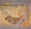
. Early Buddhist sculptures and murals excavated at Miran show artistic similarities to the traditions of Central Asia
Central Asia
Central Asia is a core region of the Asian continent from the Caspian Sea in the west, China in the east, Afghanistan in the south, and Russia in the north...
and North India
North India
North India, known natively as Uttar Bhārat or Shumālī Hindustān , is a loosely defined region in the northern part of India. The exact meaning of the term varies by usage...
and stylistic aspects of paintings found there suggest that Miran had a direct connection with the West, specifically Rome
Rome
Rome is the capital of Italy and the country's largest and most populated city and comune, with over 2.7 million residents in . The city is located in the central-western portion of the Italian Peninsula, on the Tiber River within the Lazio region of Italy.Rome's history spans two and a half...
and its provinces.
See also
- TochariansTochariansThe Tocharians were the Tocharian-speaking inhabitants of the Tarim Basin, making them the easternmost speakers of Indo-European languages in antiquity. They were known as, or at least closely related to, the Yuezhi of Chinese sources...
- Geography of ChinaGeography of ChinaChina stretches some across the East Asian landmass bordering the East China Sea, Korea Bay, Yellow Sea, and South China Sea, between North Korea and Vietnam in a changing configuration of broad plains, expansive deserts, and lofty mountain ranges, including vast areas of inhospitable terrain...
- Silk Road transmission of BuddhismSilk Road transmission of BuddhismThe Silk Road transmission of Buddhism to China is most commonly thought to have started in the late 2nd or the 1st century CE.The first documented translation efforts by Buddhist monks in China were in the 2nd century CE, possibly as a consequence of the expansion of the Kushan Empire into the...
- Kara-Khanid KhanateKara-Khanid KhanateThe Kara-Khanid Khanate was a confederation of Turkic tribes ruled by a dynasty known in literature as the Karakhanids or Ilek Khanids, . Both dynastic names represent titles with Kara Kağan being the most important Turkish title up till the end of the dynasty.The Khanate ruled Transoxania in...
- Kunlun MountainsKunlun MountainsThe Kunlun Mountains are one of the longest mountain chains in Asia, extending more than 3,000 km. In the broadest sense, it forms the northern edge of the Tibetan Plateau south of the Tarim Basin and the Gansu Corridor and continues east south of the Wei River to end at the North China Plain.The...
- Flaming MountainsFlaming MountainsThe Flaming Mountains or Gaochang Mountains are barren, eroded, red sandstone hills in Tian Shan Mountain range, Xinjiang, China. They lie near the northern rim of the Taklamakan Desert and east of the city of Turpan...
- Takla Makan Desert
- Tarim mummiesTarim mummiesThe Tarim mummies are a series of mummies discovered in the Tarim Basin in present-day Xinjiang, China, which date from 1900 BC to 200 AD. Some of the mummies are frequently associated with the presence of the Indo-European Tocharian languages in the Tarim Basin, although the evidence is not...
- Turpan water system
External links
- Downloadable article: "Evidence that a West-East admixed population lived in the Tarim Basin as early as the early Bronze Age" Li et al. BMC Biology 2010, 8:15. http://www.biomedcentral.com/content/pdf/1741-7007-8-15.pdf
- Silk Road Seattle (The Silk Road Seattle website contains many useful resources including a number of full-text historical works)
- http://idp.bl.uk/idp.a4dThe International Dunhuang ProjectInternational Dunhuang ProjectThe International Dunhuang Project is an international collaborative effort to conserve, catalogue and digitise manuscripts, printed texts, paintings, textiles and artefacts from Dunhuang and various other archaeological sites at the eastern end of the Silk Road...
]