

Tularosa Basin
Encyclopedia
The Tularosa Basin is a graben
basin
in the Basin and Range Province and within the Chihuahuan Desert
, east of the Rio Grande
in southern New Mexico
, in the Southwestern United States
.
. It covers about 6500 square miles (16,834.9 km²) (35% larger than Connecticut). It lies between the Sacramento Mountains
to the east, and the San Andres
and Oscura Mountains to the west. The basin stretches about 150 miles (241.4 km) north-south, and at its widest is about 60 miles (96.6 km) east-west. It is geologically considered part of the Rio Grande Rift
zone, which widens there due to the slight clockwise rotation of the Colorado Plateau
tectonic plate.
Notable features of the basin include the Jornada del Muerto
Desert and historic trail, the Jornada del Muerto Volcano
and Malpaís
volcanic field
, White Sands National Monument
, the Carrizozo Malpais lava flow
, and the White Sands Missile Range
with the historic Trinity nuclear test Site
. Tularosa Creek flows westward into the Tularosa Basin just north of the village of Tularosa
. The distinct northwestern New Mexico Tularosa River is located in Catron County
.
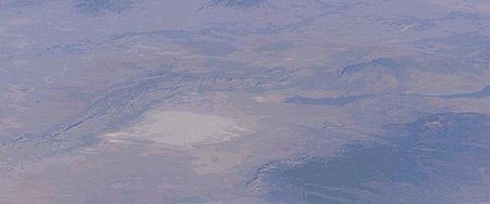
Hydrologically, the Tularosa Basin is an endorheic basin, as no water flows out of it. The basin is closed to the north by Chupadera Mesa and to the south by the Franklin
and Hueco Mountains
. Surface water that doesn't evaporate or soak into the ground eventually accumulates at playas
(intermittently dry lake beds), the largest of which is Lake Lucero at the southwest end of the White Sands dune
s. The White Sands
are a 710-km² (275-sq mi) field of white sand dunes composed of gypsum
crystals. To the north of Lake Lucero there are extensive alkali flats, which produce additional gypsum for wind deposition on the dunes.
When the Spanish arrived in the Tularosa Basin they found springs and small streams coming from the Sacramento Mountains
that fed a relatively lush grassland on the eastern side of the basin. While some sheep ranching was tried by the Spanish, and some mining, the area remained firmly under Apache control until the 1850s when the United States
established its military presence at Fort Stanton (in the Sacramento Mountains
(1855–1896), Torreon Fort (near Lincoln
) (1850s), and Camp Comfort (1858–1859) at White Sands. Under US military protection the first permanent settlement was established in 1862, when approx. 50 Hispanic farmers from the Rio Grande Valley
moved to Tularosa
. Efforts to control the Apache waned somewhat during the American Civil War
and serious Anglo settlement did not begin until the late 1870s when settlers and cattlemen from Texas began moving into the basin.
Grasslands and grazing
The native
grassland
s in the Tularosa Basin were able to support large herds in the wet years of the 1880s. When the Anglos first started running cattle, in some places the native perennial bunchgrasses grew 'as high as a horse’s shoulder' - 1–2.5 m (3.3–8.2 ft) depending on species. One cowboy estimated in 1889 that 85,000 head were mustered within the basin, but said that that was “far too heavy a burden for the range” - or beyond its carrying capacity
. The following years were ones of severe drought, and the grassland pastures never recovered from the over-grazing which continued in many instances for 75 years or more, and consequent top soil erosion and desertification. Even within the White Sands Missile Range
, where cattle grazing was eliminated in 1945, the effects from the 1890 -1945 period of overgrazing can still be seen nearly everywhere in the Range. Many areas that were historically known to be rich perennial grasslands are now xeric desert shrublands
, with creosote bush—(Larrea tridentata) predominating.
Groundwater salinization
Since surface water was unable to sustain the cattle herds, the ranchers turned to groundwater
, and the easily reachable aquifer
of 'sweet water' was pumped out and depleted from under the basin, leaving only brackish water
. Applying the groundwater to the surface resulted in additional salts being dissolved and transported back down via groundwater recharge into the aquifer, increasing its salinity. By the year 2000 it was recognized that salts in the aquifer needed to be significantly reduced if existing levels of water usage were to continue. Therefore in 2004 the Tularosa Basin National Desalination Research Facility was established in the basin at Alamogordo
, as a joint project of the Federal Bureau of Reclamation
and Sandia National Laboratories
. It is a national center for researching procedures to reduce brackish water creation and to develop new technologies for its desalination, as it is increasingly found in present day inland basin aquifers with agricultural irrigation and potable water withdrawal demands.
ecoregion
, with the former Great Plains
grassland habitat ecotone
s. Because of the closed nature of the basin, a number of unique ecological niches have developed. There are a significant number of endemic species which are only found in the Tularosa Basin. These include the White Sands pupfish—(Cyprinodon tularosa)
and the Oscura Mountains chipmunk
.
, it also extends into Doña Ana
, Sierra
, Lincoln
, and Socorro Counties
in New Mexico, and El Paso County in southwest Texas
.
Graben
In geology, a graben is a depressed block of land bordered by parallel faults. Graben is German for ditch. Graben is used for both the singular and plural....
basin
Drainage basin
A drainage basin is an extent or an area of land where surface water from rain and melting snow or ice converges to a single point, usually the exit of the basin, where the waters join another waterbody, such as a river, lake, reservoir, estuary, wetland, sea, or ocean...
in the Basin and Range Province and within the Chihuahuan Desert
Chihuahuan Desert
The Chihuahuan Desert is a desert, and an ecoregion designation, that straddles the U.S.-Mexico border in the central and northern portions of the Mexican Plateau, bordered on the west by the extensive Sierra Madre Occidental range, and overlaying northern portions of the east range, the Sierra...
, east of the Rio Grande
Rio Grande
The Rio Grande is a river that flows from southwestern Colorado in the United States to the Gulf of Mexico. Along the way it forms part of the Mexico – United States border. Its length varies as its course changes...
in southern New Mexico
New Mexico
New Mexico is a state located in the southwest and western regions of the United States. New Mexico is also usually considered one of the Mountain States. With a population density of 16 per square mile, New Mexico is the sixth-most sparsely inhabited U.S...
, in the Southwestern United States
Southwestern United States
The Southwestern United States is a region defined in different ways by different sources. Broad definitions include nearly a quarter of the United States, including Arizona, California, Colorado, Nevada, New Mexico, Oklahoma, Texas and Utah...
.
Geography
The Tularosa Basin is located primarily in Otero CountyOtero County, New Mexico
-2010:Whereas according to the 2010 U.S. Census Bureau:*72.7% White*3.5% Black*6.7% Native American*1.2% Asian*0.2% Native Hawaiian or Pacific Islander*4.2% Two or more races*11.2% Other races*34.5% Hispanic or Latino -2000:...
. It covers about 6500 square miles (16,834.9 km²) (35% larger than Connecticut). It lies between the Sacramento Mountains
Sacramento Mountains
The Sacramento Mountains are a mountain range in the south-central part of the U.S. state of New Mexico, lying just east of Alamogordo in Otero County...
to the east, and the San Andres
San Andres Mountains
The San Andres Mountains are a mountain range in the southwestern U.S. state of New Mexico, in the counties of Socorro, Sierra, and Doña Ana. The range extends about 75 miles north to south, but are only about 12 miles wide at their widest...
and Oscura Mountains to the west. The basin stretches about 150 miles (241.4 km) north-south, and at its widest is about 60 miles (96.6 km) east-west. It is geologically considered part of the Rio Grande Rift
Rio Grande Rift
The Rio Grande Rift is a north-trending continental rift zone. It separates the Colorado Plateau in the west from the interior of the North American craton on the east. The rift extends from central Colorado in the north to the state of Chihuahua, Mexico in the south. The rift zone consists of four...
zone, which widens there due to the slight clockwise rotation of the Colorado Plateau
Colorado Plateau
The Colorado Plateau, also called the Colorado Plateau Province, is a physiographic region of the Intermontane Plateaus, roughly centered on the Four Corners region of the southwestern United States. The province covers an area of 337,000 km2 within western Colorado, northwestern New Mexico,...
tectonic plate.
Notable features of the basin include the Jornada del Muerto
Jornada del Muerto
The Jornada del Muerto in the U.S. state of New Mexico was the name given by the Spanish conquistadors to the Jornada del Muerto Desert basin, and the particularly dry stretch of a route through it.The trail lead northward from central Spanish colonial New Spain, present-day Mexico, to the farthest...
Desert and historic trail, the Jornada del Muerto Volcano
Jornada del Muerto Volcano
The Jornada del Muerto Volcano is a small shield volcano and lava field in central New Mexico, about in size and reaching an elevation of . Jornada del Muerto means ""Journey of the Dead Man" in Spanish, referring to the desolate colonial era trail from New Spain through this Malpaís...
and Malpaís
Malpaís (landform)
A malpaís is a landform characterized by eroded rocks of volcanic origin in an arid environment. This describes many xeric places, but is strongly connected to Spanish-speaking countries and the Southwestern United States because of the Spanish settlers that gave the landform its name.-Badlands...
volcanic field
Volcanic field
A volcanic field is an area of the Earth's crust that is prone to localized volcanic activity. They usually contain 10 to 100 volcanoes, such as cinder cones and are usually in clusters. Lava flows may also occur...
, White Sands National Monument
White Sands National Monument
The White Sands National Monument is a U.S. National Monument located about southwest of Alamogordo in western Otero County and northeastern Dona Ana County in the state of New Mexico, at an elevation of 4235 feet...
, the Carrizozo Malpais lava flow
Carrizozo Malpais
The Carrizozo Malpais is a large lava flow on the west side of Carrizozo, New Mexico, on the northern part of the Tularosa Basin between Sierra Blanca to the southeast and the Oscura Mountains to the west....
, and the White Sands Missile Range
White Sands Missile Range
White Sands Missile Range is a rocket range of almost in parts of five counties in southern New Mexico. The largest military installation in the United States, WSMR includes the and the WSMR Otera Mesa bombing range...
with the historic Trinity nuclear test Site
Trinity test
Trinity was the code name of the first test of a nuclear weapon. This test was conducted by the United States Army on July 16, 1945, in the Jornada del Muerto desert about 35 miles southeast of Socorro, New Mexico, at the new White Sands Proving Ground, which incorporated the Alamogordo Bombing...
. Tularosa Creek flows westward into the Tularosa Basin just north of the village of Tularosa
Tularosa, New Mexico
Tularosa is a village in Otero County, New Mexico, United States. It shares its name with the Tularosa Basin, in which the town is located. To the east, Tularosa is flanked by the western edge of the Sacramento Mountains. The population was 2,864 at the 2000 census...
. The distinct northwestern New Mexico Tularosa River is located in Catron County
Catron County, New Mexico
-2010:Whereas according to the 2010 U.S. Census Bureau:*89.8% White*0.4% Black*2.7% Native American*0.2% Asian*0.0% Native Hawaiian or Pacific Islander*3.1% Two or more races*3.7% Other races*19.0% Hispanic or Latino -2000:...
.
Hydrologically, the Tularosa Basin is an endorheic basin, as no water flows out of it. The basin is closed to the north by Chupadera Mesa and to the south by the Franklin
Franklin Mountains (Texas)
The Franklin Mountains of Texas are a small range that extend from El Paso, Texas north into New Mexico. The Franklins were formed due to crustal extension related to the Cenozoic Rio Grande rift...
and Hueco Mountains
Hueco Mountains
The Hueco Mountains are a range of mountains that rise in southern Otero County, New Mexico and extend twenty-seven miles south into Texas, generally along the El Paso-Hudspeth county line just east of the city of El Paso, Texas...
. Surface water that doesn't evaporate or soak into the ground eventually accumulates at playas
Dry lake
Dry lakes are ephemeral lakebeds, or a remnant of an endorheic lake. Such flats consist of fine-grained sediments infused with alkali salts. Dry lakes are also referred to as alkali flats, sabkhas, playas or mud flats...
(intermittently dry lake beds), the largest of which is Lake Lucero at the southwest end of the White Sands dune
Dune
In physical geography, a dune is a hill of sand built by wind. Dunes occur in different forms and sizes, formed by interaction with the wind. Most kinds of dunes are longer on the windward side where the sand is pushed up the dune and have a shorter "slip face" in the lee of the wind...
s. The White Sands
White Sands National Monument
The White Sands National Monument is a U.S. National Monument located about southwest of Alamogordo in western Otero County and northeastern Dona Ana County in the state of New Mexico, at an elevation of 4235 feet...
are a 710-km² (275-sq mi) field of white sand dunes composed of gypsum
Gypsum
Gypsum is a very soft sulfate mineral composed of calcium sulfate dihydrate, with the chemical formula CaSO4·2H2O. It is found in alabaster, a decorative stone used in Ancient Egypt. It is the second softest mineral on the Mohs Hardness Scale...
crystals. To the north of Lake Lucero there are extensive alkali flats, which produce additional gypsum for wind deposition on the dunes.
History
Apache, Spanish, and U.S. 'Old West'When the Spanish arrived in the Tularosa Basin they found springs and small streams coming from the Sacramento Mountains
Sacramento Mountains
The Sacramento Mountains are a mountain range in the south-central part of the U.S. state of New Mexico, lying just east of Alamogordo in Otero County...
that fed a relatively lush grassland on the eastern side of the basin. While some sheep ranching was tried by the Spanish, and some mining, the area remained firmly under Apache control until the 1850s when the United States
United States
The United States of America is a federal constitutional republic comprising fifty states and a federal district...
established its military presence at Fort Stanton (in the Sacramento Mountains
Sacramento Mountains
The Sacramento Mountains are a mountain range in the south-central part of the U.S. state of New Mexico, lying just east of Alamogordo in Otero County...
(1855–1896), Torreon Fort (near Lincoln
Lincoln, New Mexico
Lincoln is an unincorporated community in Lincoln County, New Mexico, United States, located approximately 57 miles west of Roswell and just south of the Lincoln National Forest. The town had a population of about 800 in 1888, and Main Street has been beautifully preserved by current residents....
) (1850s), and Camp Comfort (1858–1859) at White Sands. Under US military protection the first permanent settlement was established in 1862, when approx. 50 Hispanic farmers from the Rio Grande Valley
Rio Grande Valley
The Rio Grande Valley or the Lower Rio Grande Valley, informally called The Valley, is an area located in the southernmost tip of South Texas...
moved to Tularosa
Tularosa, New Mexico
Tularosa is a village in Otero County, New Mexico, United States. It shares its name with the Tularosa Basin, in which the town is located. To the east, Tularosa is flanked by the western edge of the Sacramento Mountains. The population was 2,864 at the 2000 census...
. Efforts to control the Apache waned somewhat during the American Civil War
American Civil War
The American Civil War was a civil war fought in the United States of America. In response to the election of Abraham Lincoln as President of the United States, 11 southern slave states declared their secession from the United States and formed the Confederate States of America ; the other 25...
and serious Anglo settlement did not begin until the late 1870s when settlers and cattlemen from Texas began moving into the basin.
Grasslands and grazing
The native
Native plant
Native plant is a term to describe plants endemic or naturalized to a given area in geologic time.This includes plants that have developed, occur naturally, or existed for many years in an area...
grassland
Grassland
Grasslands are areas where the vegetation is dominated by grasses and other herbaceous plants . However, sedge and rush families can also be found. Grasslands occur naturally on all continents except Antarctica...
s in the Tularosa Basin were able to support large herds in the wet years of the 1880s. When the Anglos first started running cattle, in some places the native perennial bunchgrasses grew 'as high as a horse’s shoulder' - 1–2.5 m (3.3–8.2 ft) depending on species. One cowboy estimated in 1889 that 85,000 head were mustered within the basin, but said that that was “far too heavy a burden for the range” - or beyond its carrying capacity
Carrying capacity
The carrying capacity of a biological species in an environment is the maximum population size of the species that the environment can sustain indefinitely, given the food, habitat, water and other necessities available in the environment...
. The following years were ones of severe drought, and the grassland pastures never recovered from the over-grazing which continued in many instances for 75 years or more, and consequent top soil erosion and desertification. Even within the White Sands Missile Range
White Sands Missile Range
White Sands Missile Range is a rocket range of almost in parts of five counties in southern New Mexico. The largest military installation in the United States, WSMR includes the and the WSMR Otera Mesa bombing range...
, where cattle grazing was eliminated in 1945, the effects from the 1890 -1945 period of overgrazing can still be seen nearly everywhere in the Range. Many areas that were historically known to be rich perennial grasslands are now xeric desert shrublands
Deserts and xeric shrublands
Deserts and xeric shrublands is a biome characterized by, relating to, or requiring only a small amount of moisture.-Definition and occurrence:...
, with creosote bush—(Larrea tridentata) predominating.
Groundwater salinization
Since surface water was unable to sustain the cattle herds, the ranchers turned to groundwater
Groundwater
Groundwater is water located beneath the ground surface in soil pore spaces and in the fractures of rock formations. A unit of rock or an unconsolidated deposit is called an aquifer when it can yield a usable quantity of water. The depth at which soil pore spaces or fractures and voids in rock...
, and the easily reachable aquifer
Aquifer
An aquifer is a wet underground layer of water-bearing permeable rock or unconsolidated materials from which groundwater can be usefully extracted using a water well. The study of water flow in aquifers and the characterization of aquifers is called hydrogeology...
of 'sweet water' was pumped out and depleted from under the basin, leaving only brackish water
Brackish water
Brackish water is water that has more salinity than fresh water, but not as much as seawater. It may result from mixing of seawater with fresh water, as in estuaries, or it may occur in brackish fossil aquifers. The word comes from the Middle Dutch root "brak," meaning "salty"...
. Applying the groundwater to the surface resulted in additional salts being dissolved and transported back down via groundwater recharge into the aquifer, increasing its salinity. By the year 2000 it was recognized that salts in the aquifer needed to be significantly reduced if existing levels of water usage were to continue. Therefore in 2004 the Tularosa Basin National Desalination Research Facility was established in the basin at Alamogordo
Alamogordo, New Mexico
Alamogordo is the county seat of Otero County and a city in south-central New Mexico, United States. A desert community lying in the Tularosa Basin, it is bordered on the east by the Sacramento Mountains. It is the nearest city to Holloman Air Force Base. The population was 35,582 as of the 2000...
, as a joint project of the Federal Bureau of Reclamation
United States Bureau of Reclamation
The United States Bureau of Reclamation , and formerly the United States Reclamation Service , is an agency under the U.S...
and Sandia National Laboratories
Sandia National Laboratories
The Sandia National Laboratories, managed and operated by the Sandia Corporation , are two major United States Department of Energy research and development national laboratories....
. It is a national center for researching procedures to reduce brackish water creation and to develop new technologies for its desalination, as it is increasingly found in present day inland basin aquifers with agricultural irrigation and potable water withdrawal demands.
Ecology
The Tularosa Basin is in the Chihuahuan DesertChihuahuan Desert
The Chihuahuan Desert is a desert, and an ecoregion designation, that straddles the U.S.-Mexico border in the central and northern portions of the Mexican Plateau, bordered on the west by the extensive Sierra Madre Occidental range, and overlaying northern portions of the east range, the Sierra...
ecoregion
Ecoregion
An ecoregion , sometimes called a bioregion, is an ecologically and geographically defined area that is smaller than an ecozone and larger than an ecosystem. Ecoregions cover relatively large areas of land or water, and contain characteristic, geographically distinct assemblages of natural...
, with the former Great Plains
Great Plains
The Great Plains are a broad expanse of flat land, much of it covered in prairie, steppe and grassland, which lies west of the Mississippi River and east of the Rocky Mountains in the United States and Canada. This area covers parts of the U.S...
grassland habitat ecotone
Ecotone
An ecotone is a transition area between two biomes but different patches of the landscape, such as forest and grassland. It may be narrow or wide, and it may be local or regional...
s. Because of the closed nature of the basin, a number of unique ecological niches have developed. There are a significant number of endemic species which are only found in the Tularosa Basin. These include the White Sands pupfish—(Cyprinodon tularosa)
White Sands pupfish
The White Sands pupfish is a species of fish in the Cyprinodontidae family. It is endemic to the Tularosa Basin in southern New Mexico, in the Western United States. They are only found in two springs and two small streams in southwestNew Mexico. They are found nowhere else in the world.The White...
and the Oscura Mountains chipmunk
Chipmunk
Chipmunks are small striped squirrels native to North America and Asia. They are usually classed either as a single genus with three subgenera, or as three genera.-Etymology and taxonomy:...
.
Counties
While the Tularosa Basin lies primarily in New Mexican Otero CountyOtero County, New Mexico
-2010:Whereas according to the 2010 U.S. Census Bureau:*72.7% White*3.5% Black*6.7% Native American*1.2% Asian*0.2% Native Hawaiian or Pacific Islander*4.2% Two or more races*11.2% Other races*34.5% Hispanic or Latino -2000:...
, it also extends into Doña Ana
Doña Ana County, New Mexico
-2010:Whereas according to the 2010 U.S. Census Bureau:*74.1% White*1.7% Black*1.5% Native American*1.1% Asian*0.1% Native Hawaiian or Pacific Islander*3.0% Two or more races*18.5% Other races*65.7% Hispanic or Latino -2000:...
, Sierra
Sierra County, New Mexico
-2010:Whereas according to the 2010 U.S. Census Bureau:*85.6% White*0.4% Black*1.7% Native American*0.4% Asian*0.0% Native Hawaiian or Pacific Islander*3.3% Two or more races*8.6% Other races*28.0% Hispanic or Latino -2000:...
, Lincoln
Lincoln County, New Mexico
-2010:Whereas according to the 2010 U.S. Census Bureau:*85.1% White*0.5% Black*2.4% Native American*0.4% Asian*0.0% Native Hawaiian or Pacific Islander*2.5% Two or more races*9.1% Other races*29.8% Hispanic or Latino -2000:...
, and Socorro Counties
Socorro County, New Mexico
-2010:Whereas according to the 2010 U.S. Census Bureau:*75.1% White*1.1% Black*11.7% Native American*1.2% Asian*0.0% Native Hawaiian or Pacific Islander*2.8% Two or more races*8.1% Other races*48.5% Hispanic or Latino -2000:...
in New Mexico, and El Paso County in southwest Texas
Texas
Texas is the second largest U.S. state by both area and population, and the largest state by area in the contiguous United States.The name, based on the Caddo word "Tejas" meaning "friends" or "allies", was applied by the Spanish to the Caddo themselves and to the region of their settlement in...
.
Cities, towns and ghost towns
- AlamogordoAlamogordo, New MexicoAlamogordo is the county seat of Otero County and a city in south-central New Mexico, United States. A desert community lying in the Tularosa Basin, it is bordered on the east by the Sacramento Mountains. It is the nearest city to Holloman Air Force Base. The population was 35,582 as of the 2000...
32.90°N 105.96°W - Alvarado 32.08°N 106.14°W
- Boles AcresBoles Acres, New MexicoBoles Acres is a census-designated place in Otero County, New Mexico, United States. The population was 1,172 at the 2000 census.-Geography:Boles Acres is located at ....
32.81°N 105.99°W - CarrizozoCarrizozo, New MexicoCarrizozo is a town in and the county seat of Lincoln County, New Mexico, United States. The population was 1,036 at the 2000 census.-Geography:Carrizozo is located at ....
33.64°N 105.88°W - Coane
- Desert 32.12°N 106.11°W
- Elwood 32.18°N 106.08°W
- Estey City
- Holloman AFB 32.82°N 105.94°W ZIP Code: 88330
- Kearney 32.98°N 105.99°W
- La LuzLa Luz, New MexicoLa Luz is a census-designated place in Otero County, New Mexico, United States. The population was 1,615 at the 2000 census. It is located immediately north of Alamogordo and lies in the eastern edge of the Tularosa Basin and on the western flank of the Sacramento Mountains. Until 1848, La Luz...
32.98°N 105.94°W ZIP Code: 88337 - Lovelace 33.46°N 106.02°W
- Monista 32.83°N 106.07°W
- Omlee 32.84°N 105.97°W
- OrograndeOrogrande, New MexicoOrogrande is an unincorporated community in Otero County, New Mexico in the United States, located at latitude of 32.37111 and a longitude of -106.08389 in the Jarilla Mountains of the Tularosa Basin on U.S. 54 between El Paso, Texas and Alamogordo, New Mexico...
32.37°N 106.08°W ZIP Code: 88342 - Oscura
- Point of Sands
- Polly
- Salinas
- Three RiversThree Rivers, New MexicoThree Rivers is an unincorporated community in Otero County, United States. Its elevation is 4,570 feet .-Notable people:*Virginia Klinekole, first female president of the Mescalero Apache, 1959*Sara Misquez, president of the Mescalero Apache...
33.32°N 106.07°W ZIP Code: 88352 - TularosaTularosa, New MexicoTularosa is a village in Otero County, New Mexico, United States. It shares its name with the Tularosa Basin, in which the town is located. To the east, Tularosa is flanked by the western edge of the Sacramento Mountains. The population was 2,864 at the 2000 census...
33.07°N 106.02°W ZIP Code: 88352 - Turquoise 32.45°N 106.03°W
- Valmont 32.75°N 105.99°W
- White SandsWhite Sands, New MexicoWhite Sands is a census-designated place in Doña Ana County, New Mexico, United States. The population was 1,323 at the 2000 census. It is part of the Las Cruces Metropolitan Statistical Area...
32.38°N 106.48°W