
White Sands, New Mexico
Encyclopedia
White Sands is a census-designated place
(CDP) in Doña Ana County
, New Mexico
, United States
. The population was 1,323 at the 2000 census. It is part of the Las Cruces
Metropolitan Statistical Area. See also White Sands Missile Range
and White Sands National Monument
.
According to the United States Census Bureau
, the CDP has a total area of 3.1 square miles (8 km²), all of it land.
of 2000, there were 1,323 people, 432 households, and 355 families residing in the CDP. The population density
was 429.2 people per square mile (165.8/km²). There were 667 housing units at an average density of 216.4 per square mile (83.6/km²). The racial makeup of the CDP was 71.43% White, 11.56% African American, 0.98% Native American, 3.70% Asian, 0.08% Pacific Islander, 6.27% from other races
, and 5.97% from two or more races. Hispanic or Latino of any race were 17.61% of the population.
There were 432 households out of which 56.0% had children under the age of 18 living with them, 72.0% were married couples
living together, 6.9% had a female householder with no husband present, and 17.8% were non-families. 16.4% of all households were made up of individuals and none had someone living alone who was 65 years of age or older. The average household size was 3.06 and the average family size was 3.45.
In the CDP the population was spread out with 37.3% under the age of 18, 9.4% from 18 to 24, 39.7% from 25 to 44, 13.0% from 45 to 64, and 0.5% who were 65 years of age or older. The median age was 27 years. For every 100 females there were 105.4 males. For every 100 females age 18 and over, there were 103.7 males.
The median income for a household in the CDP was $43,500, and the median income for a family was $47,750. Males had a median income of $40,402 versus $21,250 for females. The per capita income
for the CDP was $16,186. About 1.5% of families and 2.6% of the population were below the poverty line, including 3.8% of those under age 18 and none of those age 65 or over.
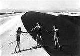
 The desert is located in Tularosa Basin New Mexico. Its white sands are not composed of quartz, unlike most desert sands, but of gypsum
and calcium sulfate
. Unlike other desert sands, it is cool to the touch, due to the high rate of evaporation of surface moisture and the fact that the sands reflect, rather than absorb, the sun's rays. At 1185 meters above sea level, there are approximately 442 total square kilometers of dune fields and is known to be the world's largest surface deposit of gypsum.
Gypsum is one of the most common mineral compounds found on Earth but is rarely seen on the surface, as it dissolves easily in water. The origin of this desert dates back to around 100 million years ago, during which it was covered by a shallow sea. As its waters gradually receded, saltwater lakes were left behind, which eventually evaporated in the sun. In addition to the salt, gypsum was also laid down in thick deposits on the old seabed.
The Sacramento and San Andres Mountains
, with the Tularosa Basin between them, took shape approximately 250 million years ago. Giant upheavals in the Earth's crust distorted the land along with the gypsum deposits, forcing them high into the air about 70 million years ago. Rainfall and melt water came from the mountains causing the gypsum to percolate out and the concentrated solutions were washed down the mountainsides. The gypsum solution accumulated in Lake Lucero, the lowest part of the Tularosa Basin. Water in the lake does not have any means of escaping except by evaporation, which leaves behind thin layers of crystallized gypsum, or selenite. Weathering then reduced these crystals to fine, sandy grains. Winds then carried the grains farther up the basin, and the grains piled in steep dunes that often reach as high as 15 m (50 ft). The winds carved more dunes and, while at the same time, carried small amounts of the gypsum grains by distances of up to 9 m (30 ft) a year.
This constant movement still occurs today, and with the added alkaline and the little amount of rainfall makes it difficult for plants to grow here leaving the desert desolate as it appears today.
Census-designated place
A census-designated place is a concentration of population identified by the United States Census Bureau for statistical purposes. CDPs are delineated for each decennial census as the statistical counterparts of incorporated places such as cities, towns and villages...
(CDP) in Doña Ana County
Doña Ana County, New Mexico
-2010:Whereas according to the 2010 U.S. Census Bureau:*74.1% White*1.7% Black*1.5% Native American*1.1% Asian*0.1% Native Hawaiian or Pacific Islander*3.0% Two or more races*18.5% Other races*65.7% Hispanic or Latino -2000:...
, New Mexico
New Mexico
New Mexico is a state located in the southwest and western regions of the United States. New Mexico is also usually considered one of the Mountain States. With a population density of 16 per square mile, New Mexico is the sixth-most sparsely inhabited U.S...
, United States
United States
The United States of America is a federal constitutional republic comprising fifty states and a federal district...
. The population was 1,323 at the 2000 census. It is part of the Las Cruces
Las Cruces, New Mexico
Las Cruces, also known as "The City of the Crosses", is the county seat of Doña Ana County, New Mexico, United States. The population was 97,618 in 2010 according to the 2010 Census, making it the second largest city in the state....
Metropolitan Statistical Area. See also White Sands Missile Range
White Sands Missile Range
White Sands Missile Range is a rocket range of almost in parts of five counties in southern New Mexico. The largest military installation in the United States, WSMR includes the and the WSMR Otera Mesa bombing range...
and White Sands National Monument
White Sands National Monument
The White Sands National Monument is a U.S. National Monument located about southwest of Alamogordo in western Otero County and northeastern Dona Ana County in the state of New Mexico, at an elevation of 4235 feet...
.
Geography
White Sands is located at 32°23′3"N 106°29′52"W (32.384064, -106.497698).According to the United States Census Bureau
United States Census Bureau
The United States Census Bureau is the government agency that is responsible for the United States Census. It also gathers other national demographic and economic data...
, the CDP has a total area of 3.1 square miles (8 km²), all of it land.
Demographics
As of the censusCensus
A census is the procedure of systematically acquiring and recording information about the members of a given population. It is a regularly occurring and official count of a particular population. The term is used mostly in connection with national population and housing censuses; other common...
of 2000, there were 1,323 people, 432 households, and 355 families residing in the CDP. The population density
Population density
Population density is a measurement of population per unit area or unit volume. It is frequently applied to living organisms, and particularly to humans...
was 429.2 people per square mile (165.8/km²). There were 667 housing units at an average density of 216.4 per square mile (83.6/km²). The racial makeup of the CDP was 71.43% White, 11.56% African American, 0.98% Native American, 3.70% Asian, 0.08% Pacific Islander, 6.27% from other races
Race (United States Census)
Race and ethnicity in the United States Census, as defined by the Federal Office of Management and Budget and the United States Census Bureau, are self-identification data items in which residents choose the race or races with which they most closely identify, and indicate whether or not they are...
, and 5.97% from two or more races. Hispanic or Latino of any race were 17.61% of the population.
There were 432 households out of which 56.0% had children under the age of 18 living with them, 72.0% were married couples
Marriage
Marriage is a social union or legal contract between people that creates kinship. It is an institution in which interpersonal relationships, usually intimate and sexual, are acknowledged in a variety of ways, depending on the culture or subculture in which it is found...
living together, 6.9% had a female householder with no husband present, and 17.8% were non-families. 16.4% of all households were made up of individuals and none had someone living alone who was 65 years of age or older. The average household size was 3.06 and the average family size was 3.45.
In the CDP the population was spread out with 37.3% under the age of 18, 9.4% from 18 to 24, 39.7% from 25 to 44, 13.0% from 45 to 64, and 0.5% who were 65 years of age or older. The median age was 27 years. For every 100 females there were 105.4 males. For every 100 females age 18 and over, there were 103.7 males.
The median income for a household in the CDP was $43,500, and the median income for a family was $47,750. Males had a median income of $40,402 versus $21,250 for females. The per capita income
Per capita income
Per capita income or income per person is a measure of mean income within an economic aggregate, such as a country or city. It is calculated by taking a measure of all sources of income in the aggregate and dividing it by the total population...
for the CDP was $16,186. About 1.5% of families and 2.6% of the population were below the poverty line, including 3.8% of those under age 18 and none of those age 65 or over.
The desert
Gypsum
Gypsum is a very soft sulfate mineral composed of calcium sulfate dihydrate, with the chemical formula CaSO4·2H2O. It is found in alabaster, a decorative stone used in Ancient Egypt. It is the second softest mineral on the Mohs Hardness Scale...
and calcium sulfate
Calcium sulfate
Calcium sulfate is a common laboratory and industrial chemical. In the form of γ-anhydrite , it is used as a desiccant. It is also used as a coagulant in products like tofu. In the natural state, unrefined calcium sulfate is a translucent, crystalline white rock...
. Unlike other desert sands, it is cool to the touch, due to the high rate of evaporation of surface moisture and the fact that the sands reflect, rather than absorb, the sun's rays. At 1185 meters above sea level, there are approximately 442 total square kilometers of dune fields and is known to be the world's largest surface deposit of gypsum.
Gypsum is one of the most common mineral compounds found on Earth but is rarely seen on the surface, as it dissolves easily in water. The origin of this desert dates back to around 100 million years ago, during which it was covered by a shallow sea. As its waters gradually receded, saltwater lakes were left behind, which eventually evaporated in the sun. In addition to the salt, gypsum was also laid down in thick deposits on the old seabed.
The Sacramento and San Andres Mountains
San Andres Mountains
The San Andres Mountains are a mountain range in the southwestern U.S. state of New Mexico, in the counties of Socorro, Sierra, and Doña Ana. The range extends about 75 miles north to south, but are only about 12 miles wide at their widest...
, with the Tularosa Basin between them, took shape approximately 250 million years ago. Giant upheavals in the Earth's crust distorted the land along with the gypsum deposits, forcing them high into the air about 70 million years ago. Rainfall and melt water came from the mountains causing the gypsum to percolate out and the concentrated solutions were washed down the mountainsides. The gypsum solution accumulated in Lake Lucero, the lowest part of the Tularosa Basin. Water in the lake does not have any means of escaping except by evaporation, which leaves behind thin layers of crystallized gypsum, or selenite. Weathering then reduced these crystals to fine, sandy grains. Winds then carried the grains farther up the basin, and the grains piled in steep dunes that often reach as high as 15 m (50 ft). The winds carved more dunes and, while at the same time, carried small amounts of the gypsum grains by distances of up to 9 m (30 ft) a year.
This constant movement still occurs today, and with the added alkaline and the little amount of rainfall makes it difficult for plants to grow here leaving the desert desolate as it appears today.