

Tropical Storm Christine (1973)
Encyclopedia
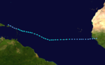
Tropical Storm Christine was the easternmost forming Atlantic tropical cyclone on record. Forming as a tropical depression over the country of Guinea
on August 25, the system tracked nearly due west for several days before intensifying into a tropical storm on August 28. However, the National Hurricane Center did not issue their first advisory on the system until its intensity was confirmed by a reconnaissance aircraft
on August 30. Turning slightly northward, Christine gradually intensified, attaining its peak strength on September 2. At that time, the storm had winds of 70 mph (110 km/h) and a minimum pressure of 996 mbar (hPa; 29.41 inHg), just below hurricane status. Shortly after, increasing wind shear
caused the system to quickly weaken. By September 4, Christine had been downgraded to a tropical depression as it tracked through the Leeward Islands
. After degenerating into a tropical wave
, the cyclone's remnants fully dissipated on September 6.
Although Christine had weakened to a tropical depression by the time it passed through the Leeward Islands, heavy rains from the storm, peaking at 11.74 in (298.2 mm), caused flooding in Puerto Rico. Over 600 homes were flooded and dozens of families had to be evacuated from several towns. One person died from electrocution after stepping on a downed wire on a flooded street. Minor damage was recorded in the Virgin Islands, mainly downed power lines which left roughly 500 people without telephone service.
 Tropical Storm Christine originated from a tropical wave
over Africa in late-August. As it neared the Atlantic Ocean, the wave spawned a tropical depression at 14.0°W
, over the country of Guinea
, on August 25. The formation of this depression was farther east than any other tropical cyclone
on record in the Atlantic hurricane basin, although storms may have gone undetected prior to the start of satellite imagery in the 1960s. This record would not be approached by any other storm until Hurricane Jeanne in 1998
, which formed at 17.4°W. This was unlike most cyclone producing waves which travel several hundred miles over water before spawning a depression. Tracking nearly due west, the depression moved over water several hours later and bypassed the Cape Verde Islands on August 27.
The following day, the depression intensified into a tropical storm; however, advisories were not issued by the National Hurricane Center
(NHC) on the system until August 30 because of the lack of reconnaissance aircraft
data. It was determined that Christine had become a tropical storm by this time after receiving reports of gale-force winds from a German cargo ship in the vicinity of the storm. The first advisory from the NHC came after a reconnaissance plane found sustained winds of 50 mph (85 km/h) and a barometric pressure of 1007 mbar (hPa; 29.74 inHg). At that time, Christine was located roughly 1000 mi (1,500 km) east of Trinidad
. Although the storm was relatively disorganized by this point, satellite imagery showed large outer bands
extending hundreds of miles (kilometres) from the storm.
By August 31, the storm began to slow and turn towards the west-northwest. The NHC noted that they did not have a firm grip on the storm and were unsure of its future track and intensity. Below average sea surface temperature
s ahead of the system would hamper significant development. Continuing on this track, Christine gradually intensified and on September 2, the storm attained its peak intensity just below hurricane-status while situated roughly 300 mi (500 km) east of Guadeloupe
. At this time, a reconnaissance aircraft recorded sustained winds of 70 mph (110 km/h) and a minimum pressure of 996 mbar (hPa; 29.41 inHg). Shortly after Christine attained this intensity, increasing wind shear
caused the storm to weaken as it neared the Leeward Islands
.
The NHC noted that a trough
ahead of Christine would determine the future of the storm. This trough would either merge with the storm and allow significant intensification, or remain separate and cause Christine to dissipate. By September 3, the low-level circulation had been displaced from all convective activity
and Christine weakened to a tropical depression. Several hours after weakening, the depression passed over Antigua
with winds of 35 mph (55 km/h). The following day, the system degenerated into a tropical wave near the northeastern coast of the Dominican Republic
. The remnants of Christine were monitored by the NHC for several days before dissipating near the trough on September 6.
project. During this project, active and passive microwave satellite imagery was used for the first time to determine the wind speed within a tropical cyclone. This was accomplished after the removal of regions of heavy rain from the data, a factor that gives inaccurate wind readings.
, Desirade, Antigua
and Barbuda
. Later that day, the gale warnings were expanded southward to include islands north of Dominica
. After Christine weakened to a tropical depression, the NHC discontinued all watches and warnings for the Leeward Islands. Schools were closed in Puerto Rico and the United States Virgin Islands as a precaution. Six scientists had to be evacuated from the small island of Aves once the storm posed a threat to them. On St. Thomas
, nine emergency shelters were opened, mainly in schools. On September 5, an emergency meeting was held by disaster officials in Puerto Rico about the threat of flooding from Christine. All residents were urged by government officials to have their disaster kits ready and be prepared to evacuate if told to do so. Firefighters, on and off-duty, were advised about the possibility of evacuations and would be pulled into work if needed.
During its passage through the Leeward Islands, Christine produced torrential rainfall, peaking at 11.74 in (298.2 mm) in eastern Puerto Rico
. A maximum of 3.16 in (80.3 mm) also fell in the United States Virgin Islands
. Rainfall totals on other islands are unknown but are likely similar to those in the U.S. Virgin Islands. The precipitation led to flooding on several islands. One person was killed during the storm after being electrocuted by a downed power line on a flooded road. Public works crews worked throughout the storm to keep roads clear; however, one road that was under construction became a "sea of mud" as crews could not clear the flood waters fast enough. The towns of Yabucoa, Humacao, Maunabo, Las Piedras and Carolinas sustained flood damage from the storm. In Yabucoa, 40 families were evacuated as 25 homes were damaged. The most substantial flooding took place in Humacao where 60 families were evacuated and 500 homes sustained damage. A total of six bridges, four sewer systems and 14 homes were damaged in Maunabo. An additional 21 people were evacuated from Las Piedras and 41 homes were damaged and in Carolinas, 23 more homes were damaged. Although there was extensive property damage, no monetary value is available.
Numerous calls were made to police in the United States Virgin Islands about downed power lines throughout the passage of the depression. High winds, gusting up to 40 mph (65 km/h) left roughly 500 people without telephone service on St. Croix. No major damage was reported on any of the affected islands in the wake of Christine. Residents in the drought stricken regions of Florida were hoping for increased rainfall from the remnant wave of Christine; however, the system did not reach the United States before dissipating. The storm's remnants only produced squally weather in Florida on September 7 and 8.
Guinea
Guinea , officially the Republic of Guinea , is a country in West Africa. Formerly known as French Guinea , it is today sometimes called Guinea-Conakry to distinguish it from its neighbour Guinea-Bissau. Guinea is divided into eight administrative regions and subdivided into thirty-three prefectures...
on August 25, the system tracked nearly due west for several days before intensifying into a tropical storm on August 28. However, the National Hurricane Center did not issue their first advisory on the system until its intensity was confirmed by a reconnaissance aircraft
Reconnaissance aircraft
A reconnaissance aircraft is a manned military aircraft designed, or adapted, to carry out aerial reconnaissance.-History:The majority of World War I aircraft were reconnaissance designs...
on August 30. Turning slightly northward, Christine gradually intensified, attaining its peak strength on September 2. At that time, the storm had winds of 70 mph (110 km/h) and a minimum pressure of 996 mbar (hPa; 29.41 inHg), just below hurricane status. Shortly after, increasing wind shear
Wind shear
Wind shear, sometimes referred to as windshear or wind gradient, is a difference in wind speed and direction over a relatively short distance in the atmosphere...
caused the system to quickly weaken. By September 4, Christine had been downgraded to a tropical depression as it tracked through the Leeward Islands
Leeward Islands
The Leeward Islands are a group of islands in the West Indies. They are the northern islands of the Lesser Antilles chain. As a group they start east of Puerto Rico and reach southward to Dominica. They are situated where the northeastern Caribbean Sea meets the western Atlantic Ocean...
. After degenerating into a tropical wave
Tropical wave
Tropical waves, easterly waves, or tropical easterly waves, also known as African easterly waves in the Atlantic region, are a type of atmospheric trough, an elongated area of relatively low air pressure, oriented north to south, which move from east to west across the tropics causing areas of...
, the cyclone's remnants fully dissipated on September 6.
Although Christine had weakened to a tropical depression by the time it passed through the Leeward Islands, heavy rains from the storm, peaking at 11.74 in (298.2 mm), caused flooding in Puerto Rico. Over 600 homes were flooded and dozens of families had to be evacuated from several towns. One person died from electrocution after stepping on a downed wire on a flooded street. Minor damage was recorded in the Virgin Islands, mainly downed power lines which left roughly 500 people without telephone service.
Meteorological history
Tropical wave
Tropical waves, easterly waves, or tropical easterly waves, also known as African easterly waves in the Atlantic region, are a type of atmospheric trough, an elongated area of relatively low air pressure, oriented north to south, which move from east to west across the tropics causing areas of...
over Africa in late-August. As it neared the Atlantic Ocean, the wave spawned a tropical depression at 14.0°W
14th meridian west
The meridian 14° west of Greenwich is a line of longitude that extends from the North Pole across the Arctic Ocean, Greenland, Iceland, the Atlantic Ocean, Africa, the Southern Ocean, and Antarctica to the South Pole....
, over the country of Guinea
Guinea
Guinea , officially the Republic of Guinea , is a country in West Africa. Formerly known as French Guinea , it is today sometimes called Guinea-Conakry to distinguish it from its neighbour Guinea-Bissau. Guinea is divided into eight administrative regions and subdivided into thirty-three prefectures...
, on August 25. The formation of this depression was farther east than any other tropical cyclone
Tropical cyclone
A tropical cyclone is a storm system characterized by a large low-pressure center and numerous thunderstorms that produce strong winds and heavy rain. Tropical cyclones strengthen when water evaporated from the ocean is released as the saturated air rises, resulting in condensation of water vapor...
on record in the Atlantic hurricane basin, although storms may have gone undetected prior to the start of satellite imagery in the 1960s. This record would not be approached by any other storm until Hurricane Jeanne in 1998
1998 Atlantic hurricane season
The 1998 Atlantic hurricane season officially began on June 1, 1998, and lasted until November 30, 1998. These dates conventionally delimit the period of each year when most tropical cyclones form in the Atlantic basin; however, the season extended through December 1 as Hurricane Nicole remained...
, which formed at 17.4°W. This was unlike most cyclone producing waves which travel several hundred miles over water before spawning a depression. Tracking nearly due west, the depression moved over water several hours later and bypassed the Cape Verde Islands on August 27.
The following day, the depression intensified into a tropical storm; however, advisories were not issued by the National Hurricane Center
National Hurricane Center
The National Hurricane Center , located at Florida International University in Miami, Florida, is the division of the National Weather Service responsible for tracking and predicting weather systems within the tropics between the Prime Meridian and the 140th meridian west poleward to the 30th...
(NHC) on the system until August 30 because of the lack of reconnaissance aircraft
Reconnaissance aircraft
A reconnaissance aircraft is a manned military aircraft designed, or adapted, to carry out aerial reconnaissance.-History:The majority of World War I aircraft were reconnaissance designs...
data. It was determined that Christine had become a tropical storm by this time after receiving reports of gale-force winds from a German cargo ship in the vicinity of the storm. The first advisory from the NHC came after a reconnaissance plane found sustained winds of 50 mph (85 km/h) and a barometric pressure of 1007 mbar (hPa; 29.74 inHg). At that time, Christine was located roughly 1000 mi (1,500 km) east of Trinidad
Trinidad
Trinidad is the larger and more populous of the two major islands and numerous landforms which make up the island nation of Trinidad and Tobago. It is the southernmost island in the Caribbean and lies just off the northeastern coast of Venezuela. With an area of it is also the fifth largest in...
. Although the storm was relatively disorganized by this point, satellite imagery showed large outer bands
Rainband
A rainband is a cloud and precipitation structure associated with an area of rainfall which is significantly elongated. Rainbands can be stratiform or convective, and are generated by differences in temperature. When noted on weather radar imagery, this precipitation elongation is referred to as...
extending hundreds of miles (kilometres) from the storm.
By August 31, the storm began to slow and turn towards the west-northwest. The NHC noted that they did not have a firm grip on the storm and were unsure of its future track and intensity. Below average sea surface temperature
Sea surface temperature
Sea surface temperature is the water temperature close to the oceans surface. The exact meaning of surface varies according to the measurement method used, but it is between and below the sea surface. Air masses in the Earth's atmosphere are highly modified by sea surface temperatures within a...
s ahead of the system would hamper significant development. Continuing on this track, Christine gradually intensified and on September 2, the storm attained its peak intensity just below hurricane-status while situated roughly 300 mi (500 km) east of Guadeloupe
Guadeloupe
Guadeloupe is an archipelago located in the Leeward Islands, in the Lesser Antilles, with a land area of 1,628 square kilometres and a population of 400,000. It is the first overseas region of France, consisting of a single overseas department. As with the other overseas departments, Guadeloupe...
. At this time, a reconnaissance aircraft recorded sustained winds of 70 mph (110 km/h) and a minimum pressure of 996 mbar (hPa; 29.41 inHg). Shortly after Christine attained this intensity, increasing wind shear
Wind shear
Wind shear, sometimes referred to as windshear or wind gradient, is a difference in wind speed and direction over a relatively short distance in the atmosphere...
caused the storm to weaken as it neared the Leeward Islands
Leeward Islands
The Leeward Islands are a group of islands in the West Indies. They are the northern islands of the Lesser Antilles chain. As a group they start east of Puerto Rico and reach southward to Dominica. They are situated where the northeastern Caribbean Sea meets the western Atlantic Ocean...
.
The NHC noted that a trough
Trough (meteorology)
A trough is an elongated region of relatively low atmospheric pressure, often associated with fronts.Unlike fronts, there is not a universal symbol for a trough on a weather chart. The weather charts in some countries or regions mark troughs by a line. In the United States, a trough may be marked...
ahead of Christine would determine the future of the storm. This trough would either merge with the storm and allow significant intensification, or remain separate and cause Christine to dissipate. By September 3, the low-level circulation had been displaced from all convective activity
Atmospheric convection
Atmospheric convection is the result of a parcel-environment instability, or temperature difference, layer in the atmosphere. Different lapse rates within dry and moist air lead to instability. Mixing of air during the day which expands the height of the planetary boundary layer leads to...
and Christine weakened to a tropical depression. Several hours after weakening, the depression passed over Antigua
Antigua
Antigua , also known as Waladli, is an island in the West Indies, in the Leeward Islands in the Caribbean region, the main island of the country of Antigua and Barbuda. Antigua means "ancient" in Spanish and was named by Christopher Columbus after an icon in Seville Cathedral, Santa Maria de la...
with winds of 35 mph (55 km/h). The following day, the system degenerated into a tropical wave near the northeastern coast of the Dominican Republic
Dominican Republic
The Dominican Republic is a nation on the island of La Hispaniola, part of the Greater Antilles archipelago in the Caribbean region. The western third of the island is occupied by the nation of Haiti, making Hispaniola one of two Caribbean islands that are shared by two countries...
. The remnants of Christine were monitored by the NHC for several days before dissipating near the trough on September 6.
Observation
Throughout its existence, Christine was monitored by astronauts in the Skylab 3Skylab 3
Skylab 3 was the second manned mission to Skylab. The Skylab 3 mission started July 28, 1973, with the launch of three astronauts on the Saturn IB rocket, and lasted 59 days, 11 hours and 9 minutes...
project. During this project, active and passive microwave satellite imagery was used for the first time to determine the wind speed within a tropical cyclone. This was accomplished after the removal of regions of heavy rain from the data, a factor that gives inaccurate wind readings.
Preparations and impact
On September 2, the National Hurricane Center issued gale warnings and hurricane watches for GuadeloupeGuadeloupe
Guadeloupe is an archipelago located in the Leeward Islands, in the Lesser Antilles, with a land area of 1,628 square kilometres and a population of 400,000. It is the first overseas region of France, consisting of a single overseas department. As with the other overseas departments, Guadeloupe...
, Desirade, Antigua
Antigua
Antigua , also known as Waladli, is an island in the West Indies, in the Leeward Islands in the Caribbean region, the main island of the country of Antigua and Barbuda. Antigua means "ancient" in Spanish and was named by Christopher Columbus after an icon in Seville Cathedral, Santa Maria de la...
and Barbuda
Barbuda
Barbuda is an island in the Eastern Caribbean, and forms part of the state of Antigua and Barbuda. It has a population of about 1,500, most of whom live in the town of Codrington.-Location:...
. Later that day, the gale warnings were expanded southward to include islands north of Dominica
Dominica
Dominica , officially the Commonwealth of Dominica, is an island nation in the Lesser Antilles region of the Caribbean Sea, south-southeast of Guadeloupe and northwest of Martinique. Its size is and the highest point in the country is Morne Diablotins, which has an elevation of . The Commonwealth...
. After Christine weakened to a tropical depression, the NHC discontinued all watches and warnings for the Leeward Islands. Schools were closed in Puerto Rico and the United States Virgin Islands as a precaution. Six scientists had to be evacuated from the small island of Aves once the storm posed a threat to them. On St. Thomas
Saint Thomas, U.S. Virgin Islands
Saint Thomas is an island in the Caribbean Sea and with the islands of Saint John, Saint Croix, and Water Island a county and constituent district of the United States Virgin Islands , an unincorporated territory of the United States. Located on the island is the territorial capital and port of...
, nine emergency shelters were opened, mainly in schools. On September 5, an emergency meeting was held by disaster officials in Puerto Rico about the threat of flooding from Christine. All residents were urged by government officials to have their disaster kits ready and be prepared to evacuate if told to do so. Firefighters, on and off-duty, were advised about the possibility of evacuations and would be pulled into work if needed.
During its passage through the Leeward Islands, Christine produced torrential rainfall, peaking at 11.74 in (298.2 mm) in eastern Puerto Rico
Puerto Rico
Puerto Rico , officially the Commonwealth of Puerto Rico , is an unincorporated territory of the United States, located in the northeastern Caribbean, east of the Dominican Republic and west of both the United States Virgin Islands and the British Virgin Islands.Puerto Rico comprises an...
. A maximum of 3.16 in (80.3 mm) also fell in the United States Virgin Islands
United States Virgin Islands
The Virgin Islands of the United States are a group of islands in the Caribbean that are an insular area of the United States. The islands are geographically part of the Virgin Islands archipelago and are located in the Leeward Islands of the Lesser Antilles.The U.S...
. Rainfall totals on other islands are unknown but are likely similar to those in the U.S. Virgin Islands. The precipitation led to flooding on several islands. One person was killed during the storm after being electrocuted by a downed power line on a flooded road. Public works crews worked throughout the storm to keep roads clear; however, one road that was under construction became a "sea of mud" as crews could not clear the flood waters fast enough. The towns of Yabucoa, Humacao, Maunabo, Las Piedras and Carolinas sustained flood damage from the storm. In Yabucoa, 40 families were evacuated as 25 homes were damaged. The most substantial flooding took place in Humacao where 60 families were evacuated and 500 homes sustained damage. A total of six bridges, four sewer systems and 14 homes were damaged in Maunabo. An additional 21 people were evacuated from Las Piedras and 41 homes were damaged and in Carolinas, 23 more homes were damaged. Although there was extensive property damage, no monetary value is available.
Numerous calls were made to police in the United States Virgin Islands about downed power lines throughout the passage of the depression. High winds, gusting up to 40 mph (65 km/h) left roughly 500 people without telephone service on St. Croix. No major damage was reported on any of the affected islands in the wake of Christine. Residents in the drought stricken regions of Florida were hoping for increased rainfall from the remnant wave of Christine; however, the system did not reach the United States before dissipating. The storm's remnants only produced squally weather in Florida on September 7 and 8.