

Transportation in Louisville, Kentucky
Encyclopedia
As with most American cities, Transportation in Louisville, Kentucky
is based primarily on automobiles. However, the city traces its foundation to the era where the river was the primary means of transportation
, and railroads has always been an important part of local industry for over a century. In more recent times Louisville has become a national hub for air cargo
, creating over 20,000 local jobs. Most recently, Louisville has come into the national spotlight for its initiatives to promote both utilitarian and recreational bicycling.
is arranged in a fairly typical system common to many cities in the United States
. Streets in the downtown business district
are arranged as a grid, with several alternating one-way
streets. Many major roads begin at or near the downtown area and travel outwards from the city like the spokes of a wheel. There are also several roads, such as Bardstown Road and Shelbyville Road, which lead outwards from Louisville to the outlying Kentucky towns of Bardstown
and Shelbyville
, respectively. (See External links for links to several online maps.)
Interstate
s I-64
, I-65
pass through and I-71
begins in Louisville. Since all three of these highways intersect at virtually the same location in the city just east of Downtown, this spot has become known as "Spaghetti Junction
", as the large mass of highways and exits resembles a bowl of spaghetti when viewed from the air. Louisville Waterfront Park
is built under and near this interchange.
I-264
(Henry Watterson Expressway east of US 31W
and Shawnee Expressway west of US 31W) and I-265
(Gene Snyder Freeway) form loops around the city on the Kentucky side. Interestingly enough, Louisville is the only city in the nation to contain two consecutively-numbered, three-digit Interstate highways.
Plans for two more bridges
to connect Louisville to Indiana, along with a reconfiguration of Spaghetti Junction, have been under consideration for years and some exploratory construction began in 2007. One bridge will be located downtown for relief of I-65 traffic. The other will connect the Indiana and Kentucky I-265's (via KY-841).
, whose IATA Airport Code
(SDF) reflects its former name of Standiford Field, although locally, this name is still widely used. The airport is also home to the UPS
Worldport
. The first runway was constructed in 1941 and used for World War II
aircraft, and the airport opened for business on November 15, 1947.
Well over 3.5 million passengers and over 3 billion pounds (1,400,000 t) of cargo pass through the airport each year. The airport, having recently completed major terminal renovations, has three operational runways. The two parallel main runways run north/south and allow for simultaneous takeoffs and landings. The east/west runway is shorter and generally only used in adverse weather conditions.
The much smaller Bowman Field is used mainly for general aviation
. Bowman Field, which opened in 1921, was the city's first airport. Some business aviation
, as well as flight instruction
and other private flying primarily operate out of this field.
Clark Regional Airport
, located in the northern Louisville suburbs, is widely popular for corporate jets due to its runways being longer than Bowman's.
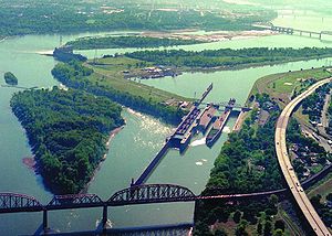 The McAlpine Locks and Dam
is located on the Kentucky
side of the Ohio River
, near the downtown
area. The locks were constructed to allow shipping past the Falls of the Ohio
. In 2001 over 55 million tons of commodities passed through the locks. A new lock was constructed to replace two of the auxiliary locks, with a projected completion date of 2008, but was completed in early 2009.
Ferry Service connected Louisville to Southern Indiana for decades, but was made obsolete when the Clark Memorial Bridge was opened.
 Public transportation includes buses and chartered vans run by the Transit Authority of River City
(TARC). The city buses serve all parts of downtown Louisville
and Jefferson County
, as well as Kentucky suburbs in Oldham County
, Bullitt County
, and the Indiana
suburbs of Jeffersonville
, Clarksville
and New Albany
. In addition to regular city buses, transit throughout the downtown hotel and shopping districts is served by a series of motorized trolleys (see right) known as the Toonerville II Trolley.
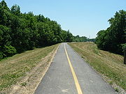
Louisville has several multi-use trails for bikes and pedestrians, many of which are not connected to each other rendering them useless for traversing the city. In the central city, there are several on-road bike paths that help cyclists get around the city by bicycle.
Like most cities, Louisville was served by electric streetcars into the 20th century. The last streetcars ran on May 1, 1948, carrying passengers to and from the Kentucky Derby
.
was once headquartered here, before it was purchased by CSX Transportation
. Today the city is served by two major freight railroads, CSX
(with a major classification yard
in the southern part of the metro area) and Norfolk Southern. Five major main lines connect Louisville to the rest of the region. Two regional railroads, the Paducah and Louisville Railway
and the Louisville and Indiana Railroad
, also serve the city. With the discontinuance of the short-lived Kentucky Cardinal in 2003, Amtrak
passenger trains
no longer serve Louisville; it is thus the fifth largest city in the country (behind Phoenix
, Columbus
, Las Vegas
, and Nashville
) with no passenger rail service.
at the League of American Bicyclists National Bike Summit in Washington D.C. where he described the history, present reality, and future of bicycling in Louisville.
The city is developing on-street bike lanes and shared-lanes, but the most notable of its bicycling initiatives is the development of a one-hundred mile "Metro Loop" trail to encircle the entire county. By the end of 2007, nearly 1/3 of this loop will be complete, with another 1/3 to 1/2 coming in the next three to five years as part of the Floyd's Fork corridor project. The entire project is being overseen by the City of Parks
initiative. $38 million dollars in federal funding has been secured for the Floyd's Fork portion of this project alone, with another $20 million in private funding.
 In 2006, Louisville was named a "Bronze-Level Bicycle Friendly Community" by the League of American Bicyclists in recognition of its commitment to developing bicycling infrastructure and promoting bicycling education and awareness. The Bike Louisville program in city government
works closely with partner organizations such as Bicycling for Louisville and the Louisville Bicycle Club to implement the recommendations of the 2005 Bike Summit as outlined in the Bike-Friendly Louisville Plan.
However, many local cyclists are frustrated with the lack of useful bike lanes connecting residential areas to business, entertainment and retail areas. For example, a $65 million redesign of Westport Road provided bike lanes only a third of the way, failing to connect residential areas like St. Matthews
with suburban retail areas. Even Mayor Abramson admitted Louisville's current bike path offerings were a "urban planning mistake".
Louisville, Kentucky
Louisville is the largest city in the U.S. state of Kentucky, and the county seat of Jefferson County. Since 2003, the city's borders have been coterminous with those of the county because of a city-county merger. The city's population at the 2010 census was 741,096...
is based primarily on automobiles. However, the city traces its foundation to the era where the river was the primary means of transportation
Mode of transport
Mode of transport is a term used to distinguish substantially different ways to perform transport. The most dominant modes of transport are aviation, land transport, which includes rail, road and off-road transport, and ship transport...
, and railroads has always been an important part of local industry for over a century. In more recent times Louisville has become a national hub for air cargo
Cargo airline
Cargo airlines are airlines dedicated to the transport of cargo. Some cargo airlines are divisions or subsidiaries of larger passenger airlines.-Logistics:...
, creating over 20,000 local jobs. Most recently, Louisville has come into the national spotlight for its initiatives to promote both utilitarian and recreational bicycling.
Roads
The city's road systemRoad
A road is a thoroughfare, route, or way on land between two places, which typically has been paved or otherwise improved to allow travel by some conveyance, including a horse, cart, or motor vehicle. Roads consist of one, or sometimes two, roadways each with one or more lanes and also any...
is arranged in a fairly typical system common to many cities in the United States
United States
The United States of America is a federal constitutional republic comprising fifty states and a federal district...
. Streets in the downtown business district
Downtown Louisville
Downtown Louisville is the largest central business district in the Commonwealth of Kentucky and the urban hub of the Louisville, Kentucky Metropolitan Area. Its boundaries are the Ohio River to the north, Hancock Street to the east, York and Jacob Streets to the south, and 9th Street to the west...
are arranged as a grid, with several alternating one-way
One-way traffic
One-way traffic is traffic that moves in a single direction. A one-way street is a street either facilitating only one-way traffic, or designed to direct vehicles to move in one direction.-General signs:...
streets. Many major roads begin at or near the downtown area and travel outwards from the city like the spokes of a wheel. There are also several roads, such as Bardstown Road and Shelbyville Road, which lead outwards from Louisville to the outlying Kentucky towns of Bardstown
Bardstown, Kentucky
As of the census of 2010, there were 11,700 people, 4,712 households, and 2,949 families residing in the city. The population density was . There were 5,113 housing units at an average density of...
and Shelbyville
Shelbyville, Kentucky
As of the census of 2000, there were 10,085 people, 3,822 households, and 2,549 families residing in the city. The population density was 1,333.5 people per square mile . There were 4,117 housing units at an average density of 544.4 per square mile...
, respectively. (See External links for links to several online maps.)
Interstate
Interstate Highway System
The Dwight D. Eisenhower National System of Interstate and Defense Highways, , is a network of limited-access roads including freeways, highways, and expressways forming part of the National Highway System of the United States of America...
s I-64
Interstate 64
Interstate 64 is an Interstate Highway in the Midwestern and Southeastern United States. Its western terminus is at I-70, U.S. 40, and U.S. 61 in Wentzville, Missouri. Its eastern terminus is at an interchange with I-264 and I-664 at Bowers Hill in Chesapeake, Virginia. As I-64 is concurrent with...
, I-65
Interstate 65
Interstate 65 is a major Interstate Highway in the United States. The southern terminus is located at an intersection with Interstate 10 in Mobile, Alabama, and its northern terminus is at an interchange with Interstate 90 , U.S. Route 12, and U.S...
pass through and I-71
Interstate 71
Interstate 71 is an Interstate Highway in the Great Lakes/Midwestern and Southeastern region of the United States. Its southern terminus is at an interchange with Interstate 64 and Interstate 65 in Louisville, Kentucky. Its northern terminus is at an interchange with Interstate 90 in Cleveland,...
begins in Louisville. Since all three of these highways intersect at virtually the same location in the city just east of Downtown, this spot has become known as "Spaghetti Junction
Kennedy Interchange
The Kennedy Interchange, unofficially, though universally, referred to as Spaghetti Junction, is the intersection of Interstates 64, 65 and 71 at the northeastern edge of downtown Louisville, Kentucky, USA. It is named for the John F...
", as the large mass of highways and exits resembles a bowl of spaghetti when viewed from the air. Louisville Waterfront Park
Louisville Waterfront Park
Louisville Waterfront Park is a municipal park adjacent to the downtown area of Louisville, Kentucky and the Ohio River. Specifically, it is adjacent to Louisville's wharf and Riverfront Plaza/Belvedere, which are situated to the west of the park....
is built under and near this interchange.
I-264
Interstate 264 (Kentucky)
The Henry Watterson Expressway, also known as the Georgia Davis Powers/Shawnee Expressway west of US 31W, is one of two Interstate Highways in the United States designated as Interstate 264 . It is 22.93 miles in length, and runs an open circle around central Louisville, Kentucky...
(Henry Watterson Expressway east of US 31W
U.S. Route 31W
U.S. Route 31W is the westernmost of two parallel routes for U.S. Route 31 from Nashville, Tennessee to Louisville, Kentucky. At one time, it split with U.S...
and Shawnee Expressway west of US 31W) and I-265
Interstate 265
Interstate 265 is an Interstate Highway ringing the Louisville, Kentucky metropolitan area, which includes southern Indiana, although the Indiana and Kentucky segments remain separate at the present time. In Kentucky it only runs through Jefferson County, from Interstate 71 in northeastern...
(Gene Snyder Freeway) form loops around the city on the Kentucky side. Interestingly enough, Louisville is the only city in the nation to contain two consecutively-numbered, three-digit Interstate highways.
Plans for two more bridges
Ohio River Bridges Project
The Ohio River Bridges Project is a controversial Louisville metropolitan area transportation project involving the reconstruction of the Kennedy Interchange , the completion of two new Ohio River bridges and the reconstruction of ramps on Interstate 65 between I-264 and downtown.One bridge will be...
to connect Louisville to Indiana, along with a reconfiguration of Spaghetti Junction, have been under consideration for years and some exploratory construction began in 2007. One bridge will be located downtown for relief of I-65 traffic. The other will connect the Indiana and Kentucky I-265's (via KY-841).
Airports
Louisville's main airport is the centrally located Louisville International AirportLouisville International Airport
Louisville International Airport is a joint civil-military public airport centrally located in the city of Louisville in Jefferson County, Kentucky, USA. The airport covers 1,200 acres and has three runways. Its IATA airport code SDF is based on the airport's former name, Standiford Field...
, whose IATA Airport Code
IATA airport code
An IATA airport code, also known an IATA location identifier, IATA station code or simply a location identifier, is a three-letter code designating many airports around the world, defined by the International Air Transport Association...
(SDF) reflects its former name of Standiford Field, although locally, this name is still widely used. The airport is also home to the UPS
United Parcel Service
United Parcel Service, Inc. , typically referred to by the acronym UPS, is a package delivery company. Headquartered in Sandy Springs, Georgia, United States, UPS delivers more than 15 million packages a day to 6.1 million customers in more than 220 countries and territories around the...
Worldport
Worldport (UPS air hub)
Worldport is the worldwide air hub for UPS located at the Louisville International Airport in Louisville, Kentucky. Although UPS has had a hub at Louisville since 1980, the term was not used officially by the company until 2002, after a $1 billion, five-year expansion...
. The first runway was constructed in 1941 and used for World War II
World War II
World War II, or the Second World War , was a global conflict lasting from 1939 to 1945, involving most of the world's nations—including all of the great powers—eventually forming two opposing military alliances: the Allies and the Axis...
aircraft, and the airport opened for business on November 15, 1947.
Well over 3.5 million passengers and over 3 billion pounds (1,400,000 t) of cargo pass through the airport each year. The airport, having recently completed major terminal renovations, has three operational runways. The two parallel main runways run north/south and allow for simultaneous takeoffs and landings. The east/west runway is shorter and generally only used in adverse weather conditions.
The much smaller Bowman Field is used mainly for general aviation
General aviation
General aviation is one of the two categories of civil aviation. It refers to all flights other than military and scheduled airline and regular cargo flights, both private and commercial. General aviation flights range from gliders and powered parachutes to large, non-scheduled cargo jet flights...
. Bowman Field, which opened in 1921, was the city's first airport. Some business aviation
Business Aviation
Business Aviation was an airline based in Kinshasa in the Democratic Republic of the Congo. It was established in 1998 and operated scheduled domestic and international services, as well as charter flights and wet-lease services. Its main base was N'Dolo Airport, Kinshasa...
, as well as flight instruction
Flight training
Flight training is a course of study used when learning to pilot an aircraft. The overall purpose of primary and intermediate flight training is the acquisition and honing of basic airmanship skills....
and other private flying primarily operate out of this field.
Clark Regional Airport
Clark Regional Airport
Clark Regional Airport , often referred to as the Clark County Airport, is a public airport five miles north of the central business district of Jeffersonville, a city in Clark County, Indiana, United States. It is owned by the Clark County Board Aviation Commission...
, located in the northern Louisville suburbs, is widely popular for corporate jets due to its runways being longer than Bowman's.
Waterways
McAlpine Locks and Dam
The McAlpine Locks and Dam refers to the series of locks and the hydroelectric dam in Louisville, Kentucky at the Falls of the Ohio. They are located at mile point 606.8 and control a 72.9 mile long navigation pool...
is located on the Kentucky
Kentucky
The Commonwealth of Kentucky is a state located in the East Central United States of America. As classified by the United States Census Bureau, Kentucky is a Southern state, more specifically in the East South Central region. Kentucky is one of four U.S. states constituted as a commonwealth...
side of the Ohio River
Ohio River
The Ohio River is the largest tributary, by volume, of the Mississippi River. At the confluence, the Ohio is even bigger than the Mississippi and, thus, is hydrologically the main stream of the whole river system, including the Allegheny River further upstream...
, near the downtown
Downtown Louisville
Downtown Louisville is the largest central business district in the Commonwealth of Kentucky and the urban hub of the Louisville, Kentucky Metropolitan Area. Its boundaries are the Ohio River to the north, Hancock Street to the east, York and Jacob Streets to the south, and 9th Street to the west...
area. The locks were constructed to allow shipping past the Falls of the Ohio
Falls of the Ohio National Wildlife Conservation Area
The Falls of the Ohio National Wildlife Conservation Area is a national, bi-state area on the Ohio River near Louisville, Kentucky in the United States, administered by the U.S. Army Corps of Engineers. Federal status was awarded in 1981.- Overview :...
. In 2001 over 55 million tons of commodities passed through the locks. A new lock was constructed to replace two of the auxiliary locks, with a projected completion date of 2008, but was completed in early 2009.
Ferry Service connected Louisville to Southern Indiana for decades, but was made obsolete when the Clark Memorial Bridge was opened.
Public transit
Transit Authority of River City
The Transit Authority of River City is the major public transportation provider for the Louisville, Kentucky, United States metro area, which includes parts of Southern Indiana. This includes the Kentucky suburbs of Oldham County, Bullitt County, Clark County, and Floyd County in southern Indiana...
(TARC). The city buses serve all parts of downtown Louisville
Downtown Louisville
Downtown Louisville is the largest central business district in the Commonwealth of Kentucky and the urban hub of the Louisville, Kentucky Metropolitan Area. Its boundaries are the Ohio River to the north, Hancock Street to the east, York and Jacob Streets to the south, and 9th Street to the west...
and Jefferson County
Jefferson County, Kentucky
As of the census of 2000, there were 693,604 people, 287,012 households, and 183,113 families residing in the county. The population density was . There were 305,835 housing units at an average density of...
, as well as Kentucky suburbs in Oldham County
Oldham County, Kentucky
As of the census of 2000, there were 46,178 people, 14,856 households, and 12,196 families residing in the county. The population density was . There were 15,541 housing units at an average density of...
, Bullitt County
Bullitt County, Kentucky
As of the census of 2000, there were 61,236 people, 22,171 households, and 17,736 families residing in the county. The population density was . There were 23,160 housing units at an average density of...
, and the Indiana
Indiana
Indiana is a US state, admitted to the United States as the 19th on December 11, 1816. It is located in the Midwestern United States and Great Lakes Region. With 6,483,802 residents, the state is ranked 15th in population and 16th in population density. Indiana is ranked 38th in land area and is...
suburbs of Jeffersonville
Jeffersonville, Indiana
Jeffersonville is a city in Clark County, Indiana, along the Ohio River. Locally, the city is often referred to by the abbreviated name Jeff. It is directly across the Ohio River to the north of Louisville, Kentucky along I-65. The population was 44,953 at the 2010 census...
, Clarksville
Clarksville, Indiana
Clarksville is a town in Clark County, Indiana, United States, along the Ohio River as a part of the Louisville Metropolitan area. The population was 21,724 at the 2010 census. The town, once a home site to George Rogers Clark, was founded in 1783 and is the oldest American town in the Northwest...
and New Albany
New Albany, Indiana
New Albany is a city in Floyd County, Indiana, United States, situated along the Ohio River opposite Louisville, Kentucky. In 1900, 20,628 people lived in New Albany; in 1910, 20,629; in 1920, 22,992; and in 1940, 25,414. The population was 36,372 at the 2010 census. The city is the county seat of...
. In addition to regular city buses, transit throughout the downtown hotel and shopping districts is served by a series of motorized trolleys (see right) known as the Toonerville II Trolley.
Louisville has several multi-use trails for bikes and pedestrians, many of which are not connected to each other rendering them useless for traversing the city. In the central city, there are several on-road bike paths that help cyclists get around the city by bicycle.
Like most cities, Louisville was served by electric streetcars into the 20th century. The last streetcars ran on May 1, 1948, carrying passengers to and from the Kentucky Derby
Kentucky Derby
The Kentucky Derby is a Grade I stakes race for three-year-old Thoroughbred horses, held annually in Louisville, Kentucky, United States on the first Saturday in May, capping the two-week-long Kentucky Derby Festival. The race is one and a quarter mile at Churchill Downs. Colts and geldings carry...
.
Rail
Louisville has historically been a major center for railway traffic. The Louisville and Nashville RailroadLouisville and Nashville Railroad
The Louisville and Nashville Railroad was a Class I railroad that operated freight and passenger services in the southeast United States.Chartered by the state of Kentucky in 1850, the L&N, as it was generally known, grew into one of the great success stories of American business...
was once headquartered here, before it was purchased by CSX Transportation
CSX Transportation
CSX Transportation operates a Class I railroad in the United States known as the CSX Railroad. It is the main subsidiary of the CSX Corporation. The company is headquartered in Jacksonville, Florida, and owns approximately 21,000 route miles...
. Today the city is served by two major freight railroads, CSX
CSX Transportation
CSX Transportation operates a Class I railroad in the United States known as the CSX Railroad. It is the main subsidiary of the CSX Corporation. The company is headquartered in Jacksonville, Florida, and owns approximately 21,000 route miles...
(with a major classification yard
Classification yard
A classification yard or marshalling yard is a railroad yard found at some freight train stations, used to separate railroad cars on to one of several tracks. First the cars are taken to a track, sometimes called a lead or a drill...
in the southern part of the metro area) and Norfolk Southern. Five major main lines connect Louisville to the rest of the region. Two regional railroads, the Paducah and Louisville Railway
Paducah and Louisville Railway
The Paducah & Louisville Railway is a Class II railroad that operates freight service between Paducah and Louisville, Kentucky.The 270-mile line was purchased from Illinois Central Gulf Railroad in August, 1986. The 223-mile main route runs between Paducah and Louisville with a branch line from...
and the Louisville and Indiana Railroad
Louisville and Indiana Railroad
The Louisville and Indiana Railroad is a Class III railroad that operates freight service between Indianapolis, Indiana and Louisville, Kentucky, with a major yard and maintenance shop in Jeffersonville, Indiana....
, also serve the city. With the discontinuance of the short-lived Kentucky Cardinal in 2003, Amtrak
Amtrak
The National Railroad Passenger Corporation, doing business as Amtrak , is a government-owned corporation that was organized on May 1, 1971, to provide intercity passenger train service in the United States. "Amtrak" is a portmanteau of the words "America" and "track". It is headquartered at Union...
passenger trains
Train
A train is a connected series of vehicles for rail transport that move along a track to transport cargo or passengers from one place to another place. The track usually consists of two rails, but might also be a monorail or maglev guideway.Propulsion for the train is provided by a separate...
no longer serve Louisville; it is thus the fifth largest city in the country (behind Phoenix
Phoenix, Arizona
Phoenix is the capital, and largest city, of the U.S. state of Arizona, as well as the sixth most populated city in the United States. Phoenix is home to 1,445,632 people according to the official 2010 U.S. Census Bureau data...
, Columbus
Columbus, Ohio
Columbus is the capital of and the largest city in the U.S. state of Ohio. The broader metropolitan area encompasses several counties and is the third largest in Ohio behind those of Cleveland and Cincinnati. Columbus is the third largest city in the American Midwest, and the fifteenth largest city...
, Las Vegas
Las Vegas, Nevada
Las Vegas is the most populous city in the U.S. state of Nevada and is also the county seat of Clark County, Nevada. Las Vegas is an internationally renowned major resort city for gambling, shopping, and fine dining. The city bills itself as The Entertainment Capital of the World, and is famous...
, and Nashville
Nashville, Tennessee
Nashville is the capital of the U.S. state of Tennessee and the county seat of Davidson County. It is located on the Cumberland River in Davidson County, in the north-central part of the state. The city is a center for the health care, publishing, banking and transportation industries, and is home...
) with no passenger rail service.
Bikeways
Since its first Bike Summit in 2005, Louisville has rapidly gained recognition for its bicycling initiatives. In March 2007, Mayor Jerry Abramson delivered the keynote addressKeynote
A keynote in literature, music, or public speaking establishes the principal underlying theme. In corporate or commercial settings, greater importance is attached to the delivery of a keynote speech or keynote address...
at the League of American Bicyclists National Bike Summit in Washington D.C. where he described the history, present reality, and future of bicycling in Louisville.
The city is developing on-street bike lanes and shared-lanes, but the most notable of its bicycling initiatives is the development of a one-hundred mile "Metro Loop" trail to encircle the entire county. By the end of 2007, nearly 1/3 of this loop will be complete, with another 1/3 to 1/2 coming in the next three to five years as part of the Floyd's Fork corridor project. The entire project is being overseen by the City of Parks
City of Parks
City of Parks is a municipal project to create a continuous paved pedestrian and biking trail around the city of Louisville, Kentucky while also adding a large amount of park land. The project was announced on February 22, 2005...
initiative. $38 million dollars in federal funding has been secured for the Floyd's Fork portion of this project alone, with another $20 million in private funding.
Local government
Local government refers collectively to administrative authorities over areas that are smaller than a state.The term is used to contrast with offices at nation-state level, which are referred to as the central government, national government, or federal government...
works closely with partner organizations such as Bicycling for Louisville and the Louisville Bicycle Club to implement the recommendations of the 2005 Bike Summit as outlined in the Bike-Friendly Louisville Plan.
However, many local cyclists are frustrated with the lack of useful bike lanes connecting residential areas to business, entertainment and retail areas. For example, a $65 million redesign of Westport Road provided bike lanes only a third of the way, failing to connect residential areas like St. Matthews
St. Matthews, Kentucky
St. Matthews is the 20th largest city in Kentucky, United States and is a prominent suburb of Louisville. It is located 8 miles east of downtown Louisville in Jefferson County. It is one of the state's major shopping areas, being home to second and fifth largest malls in Kentucky St. Matthews is...
with suburban retail areas. Even Mayor Abramson admitted Louisville's current bike path offerings were a "urban planning mistake".