Transportation in Honduras
Encyclopedia


Transport
Transport or transportation is the movement of people, cattle, animals and goods from one location to another. Modes of transport include air, rail, road, water, cable, pipeline, and space. The field can be divided into infrastructure, vehicles, and operations...
in Honduras
Honduras
Honduras is a republic in Central America. It was previously known as Spanish Honduras to differentiate it from British Honduras, which became the modern-day state of Belize...
, a country in Central America
Central America
Central America is the central geographic region of the Americas. It is the southernmost, isthmian portion of the North American continent, which connects with South America on the southeast. When considered part of the unified continental model, it is considered a subcontinent...
.
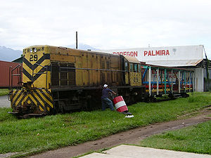
Railways
- Total: 699 km
- narrow gauge: 349 km
- gauge: 246 km
- gauge
Railway links with adjacent countries
(North to South)El Salvador
Transport in El Salvador
-Railways:*total: 602 km . Rehabilitation in progress*narrow gauge: 602 km gauge...
- no Guatemala - none in use - break-of-gauge
Break-of-gauge
With railways, a break-of-gauge occurs where a line of one gauge meets a line of a different gauge. Trains and rolling stock cannot run through without some form of conversion between gauges, and freight and passengers must otherwise be transloaded...
/ (?) http://www.lonelyplanet.com/destinations/central_america/honduras/get.htm Nicaragua - noFERISTSA
FERISTSA
FERISTSA was the name of a proposed USD $3 billion privately owned commercial railroad going from the Panama Canal Railway Company through the entire length of Central America, linking with Mexico's rail system at the Guatemala border, and thus to the United States of America.- Description :The...
Railway would connect Mexico with Panama via Honduras.
Atlantic OceanAtlantic OceanThe Atlantic Ocean is the second-largest of the world's oceanic divisions. With a total area of about , it covers approximately 20% of the Earth's surface and about 26% of its water surface area...
- Puerto CortésPuerto Cortés-Geography:It is on the Caribbean Sea coast, north of San Pedro Sula and east of Omoa, at 15.85° N, 87.94° W. It has a natural bay.It is Honduras's main sea port and it is considered the most important seaport in Central America...
, pop. 44,696 hab., off San Pedro Sula - TelaTelaTela is a town in Honduras on the northern Caribbean coast. It is located in the department of Atlantida.-History:Tela was founded by the Spanish conquistador Cristóbal de Olid on 3 May 1524 near an indigenous town named Tehuacán, ruled by a cacique named Cucumba which had a very good source of...
, pop. 28,335 hab. - La CeibaLa CeibaLa Ceiba is a port city on the northern coast of Honduras in Central America. It is located on the southern edge of the Caribbean, forming part of the south eastern boundary of the Gulf of Honduras...
, pop. 114,584 hab. - Puerto CastillaPuerto CastillaPuerto Castilla is a village in Honduras.This port city on the Caribbean Sea was the one-time site of the United Fruit Company's Castilla Division which specialized in the growth, cultivation and shipments of the Gros Michel banana...
, off Trujillo - RoatanRoatánRoatán, located between the islands of Útila and Guanaja, is the largest of Honduras' Bay Islands. The island was formerly known as Ruatan and Rattan...
, pop. 6,502 hab.
Merchant marine
- total: 306 ships (1,000 GRTGross Register TonnageGross register tonnage a ship's total internal volume expressed in "register tons", one of which equals to a volume of . It is calculated from the total permanently enclosed capacity of the vessel. The ship's net register tonnage is obtained by reducing the volume of non-revenue-earning spaces i.e...
or over) totaling 848,150 GRT/ - ships by type: (1999 est.)
- bulk carrierBulk carrierA bulk carrier, bulk freighter, or bulker is a merchant ship specially designed to transport unpackaged bulk cargo, such as grains, coal, ore, and cement in its cargo holds. Since the first specialized bulk carrier was built in 1852, economic forces have fueled the development of these ships,...
s 26 - cargo shipCargo shipA cargo ship or freighter is any sort of ship or vessel that carries cargo, goods, and materials from one port to another. Thousands of cargo carriers ply the world's seas and oceans each year; they handle the bulk of international trade...
s 187 - chemical tankerChemical tankerA chemical tanker is a type of tanker designed to transport chemicals in bulk.Ocean-going chemical tankers generally range from to in size, which is considerably smaller than the average size of other tanker types due to the specialised nature of their cargoes and the size restrictions of the...
s 5 - container shipContainer shipContainer ships are cargo ships that carry all of their load in truck-size intermodal containers, in a technique called containerization. They form a common means of commercial intermodal freight transport.-History:...
s 7 - livestock carrier 1
- passenger shipPassenger shipA passenger ship is a ship whose primary function is to carry passengers. The category does not include cargo vessels which have accommodations for limited numbers of passengers, such as the ubiquitous twelve-passenger freighters once common on the seas in which the transport of passengers is...
s 2
- passenger/cargo ships
Passenger shipA passenger ship is a ship whose primary function is to carry passengers. The category does not include cargo vessels which have accommodations for limited numbers of passengers, such as the ubiquitous twelve-passenger freighters once common on the seas in which the transport of passengers is...
4- petroleum tanker 43
- refrigerated cargo ships
Reefer (ship)A refrigerator ship is a type of ship typically used to transport perishable commodities which require temperature-controlled transportation, mostly fruits, meat, fish, vegetables, dairy products and other foodstuffs....
15- roll-on/roll-off 9
- short-sea passenger ships
Coastal trading vesselCoastal trading vessels, also known as coasters, are shallow-hulled ships used for trade between locations on the same island or continent. Their shallow hulls mean that they can get through reefs where deeper-hulled sea-going ships usually cannot....
5- vehicle carrier 2
- bulk carrier
- note:
a flag of convenience
Flag of convenience
The term flag of convenience describes the business practice of registering a merchant ship in a sovereign state different from that of the ship's owners, and flying that state's civil ensign on the ship. Ships are registered under flags of convenience to reduce operating costs or avoid the...
registry; (1998 est.)
- RussiaRussiaRussia or , officially known as both Russia and the Russian Federation , is a country in northern Eurasia. It is a federal semi-presidential republic, comprising 83 federal subjects...
owns 6 ships - VietnamVietnamVietnam – sometimes spelled Viet Nam , officially the Socialist Republic of Vietnam – is the easternmost country on the Indochina Peninsula in Southeast Asia. It is bordered by China to the north, Laos to the northwest, Cambodia to the southwest, and the South China Sea –...
1 - SingaporeSingaporeSingapore , officially the Republic of Singapore, is a Southeast Asian city-state off the southern tip of the Malay Peninsula, north of the equator. An island country made up of 63 islands, it is separated from Malaysia by the Straits of Johor to its north and from Indonesia's Riau Islands by the...
3 - North KoreaNorth KoreaThe Democratic People’s Republic of Korea , , is a country in East Asia, occupying the northern half of the Korean Peninsula. Its capital and largest city is Pyongyang. The Korean Demilitarized Zone serves as the buffer zone between North Korea and South Korea...
1
AirportAirportAn airport is a location where aircraft such as fixed-wing aircraft, helicopters, and blimps take off and land. Aircraft may be stored or maintained at an airport...
s
119 (1999 est.)
- Main international airports: San Pedro SulaSan Pedro SulaSan Pedro Sula is a city in Honduras. It is located in the northwest corner of the country, in the Valle de Sula , about 60 km south of Puerto Cortés on the Caribbean. With an estimated population of 638,259 people in the main municipality, and 802,598 in its metro area , it is the second...
and TegucigalpaTegucigalpaTegucigalpa , and commonly referred as Tegus , is the capital of Honduras and seat of government of the Republic, along with its twin sister Comayagüela. Founded on September 29, 1578 by the Spanish, it became the country's capital on October 30, 1880 under President Marco Aurelio Soto...
. - Other international airports: RoatanRoatánRoatán, located between the islands of Útila and Guanaja, is the largest of Honduras' Bay Islands. The island was formerly known as Ruatan and Rattan...
and La CeibaLa CeibaLa Ceiba is a port city on the northern coast of Honduras in Central America. It is located on the southern edge of the Caribbean, forming part of the south eastern boundary of the Gulf of Honduras...
Airports - with paved runways
- total: 12
- 2,438 to 3,047 m: 3
- 1,524 to 2,437 m: 2
- 914 to 1,523 m: 4
- under 914 m: 3 (1999 est.)
Airports - with unpaved runways
- total: 107
- 1,524 to 2,437 m: 2
- 914 to 1,523 m: 21
- under 914 m: 84 (1999 est.)

