
Transport in El Salvador
Encyclopedia
Railways
- total: 602 km (single track; all traffic suspended; note - some sections abandoned, unusable). Rehabilitation in progress
- narrow gauge: 602 km gauge
Railway links with adjacent countries
Guatemala - gauge both countries, currently closed. Honduras - noFERISTSAFERISTSA
FERISTSA was the name of a proposed USD $3 billion privately owned commercial railroad going from the Panama Canal Railway Company through the entire length of Central America, linking with Mexico's rail system at the Guatemala border, and thus to the United States of America.- Description :The...
Railway was proposed to connect Mexico with Panama.
Streets
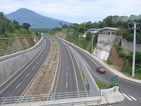
- total: 10,029 km
- paved: 1,986 km (including 327 km of HighwayHighwayA highway is any public road. In American English, the term is common and almost always designates major roads. In British English, the term designates any road open to the public. Any interconnected set of highways can be variously referred to as a "highway system", a "highway network", or a...
s) - unpaved: 8,043 km (1999 est.)
Pacific Ocean
- AcajutlaAcajutlaAcajutla is a seaport and municipality in Sonsonate Department, El Salvador. The town is located at on the Pacific Coast of Central America and is El Salvador's principal seaport from which a large portion of the nation's exports of coffee, sugar, and balsam are shipped. As a municipality,...
- Puerto Cutuco
- La Libertad
- La UniónLa Unión, El SalvadorLa Unión is a municipality in the La Unión department of El Salvador.It is the capital city of the Department of its same name. It is the largest city in the department also with a population of almost 26,739 inhabitants. On January 16, 2005 the government of El Salvador started building a new...
- Puerto El TriunfoPuerto El TriunfoPuerto El Triunfo is a municipality in the Usulután department of El SalvadorBeginning as a coffee trade port, Puerto El triunfo was founded in 1875 as a need for the exportation of the coffee industry in northern Usulután...
Airports - with paved runways
- total: 4
- over 3,047 m: 1
- 1,524 to 2,437 m: 1
- 914 to 1,523 m: 2 (2006 est.)
Airports - with unpaved runways
- total: 71
- 1,524 to 2,437 m: 1
- 914 to 1,523 m: 14
- under 914 m: 56 (2006 est.)
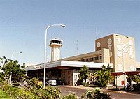
Airports by name
- El Salvador International AirportEl Salvador International AirportEl Salvador International Airport , commonly known as Comalapa International Airport or Cuscatlán International Airport, is located about from San Salvador in El Salvador...
- Ilopango International AirportIlopango International AirportIlopango International Airport is an airport located on the eastern part of the city of San Salvador, El Salvador, once serving the city as its international airport until it was replaced by the larger and more modern Comalapa International Airport, located about 50 km south of the city....
- El Tamarindo