

Transport in Brisbane
Encyclopedia
Brisbane
Brisbane is the capital and most populous city in the Australian state of Queensland and the third most populous city in Australia. Brisbane's metropolitan area has a population of over 2 million, and the South East Queensland urban conurbation, centred around Brisbane, encompasses a population of...
, the capital and largest city of Queensland
Queensland
Queensland is a state of Australia, occupying the north-eastern section of the mainland continent. It is bordered by the Northern Territory, South Australia and New South Wales to the west, south-west and south respectively. To the east, Queensland is bordered by the Coral Sea and Pacific Ocean...
, Australia
Australia
Australia , officially the Commonwealth of Australia, is a country in the Southern Hemisphere comprising the mainland of the Australian continent, the island of Tasmania, and numerous smaller islands in the Indian and Pacific Oceans. It is the world's sixth-largest country by total area...
, is provided by road, rail, river and bay ferries, footpaths, bikepaths, sea and air.
Transport around Brisbane is managed by both the Brisbane City Council and the Government of Queensland
Government of Queensland
The Government of Queensland is commonly known as the "Queensland Government".The form of the Government of Queensland is prescribed in its Constitution, which dates from 1859, although it has been amended many times since then...
, which owns Queensland Rail
Queensland Rail
Queensland Rail, also known as QR, is a government-owned railway operator in the state of Queensland. Under the control of the Queensland Government, Queensland Rail operates the inner-city and long-distance passenger services, as well as some freight operations and gives railway access to other...
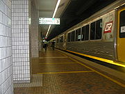
. Public commuter rail transport is by Citytrain
CityTrain
Citytrain is the brand name of urban, suburban and inter-urban electric passenger railway services in South East Queensland, Australia. Its network, centering in Brisbane, the state capital of Queensland, is approximately in route length...
, an electric train system operated by Queensland Rail
Queensland Rail
Queensland Rail, also known as QR, is a government-owned railway operator in the state of Queensland. Under the control of the Queensland Government, Queensland Rail operates the inner-city and long-distance passenger services, as well as some freight operations and gives railway access to other...
. Road transport is via the standard residential street network managed by Brisbane City Council and the connecting arterial road network which is managed by Queensland Main Roads
Department of Main Roads (Queensland)
The Queensland Government Department of Transport and Main Roads plans, designs, builds and maintains the 34,000km of Queensland state-controlled roads, under the Minister for Local Government and Main Roads. Warren Pitt is the current Minister for Local Government and Main Roads.The department is...
. The public bus transport system is operated by the Brisbane City Council, and utilises the road network as well as dedicated bus lanes and busways. Public transport on and across the Brisbane River
Brisbane River
The Brisbane River is the longest river in south east Queensland, Australia, and flows through the city of Brisbane, before emptying into Moreton Bay. John Oxley was the first European to explore the river who named it after the Governor of New South Wales, Thomas Brisbane in 1823...
is provided by the Cityferry (inner city) and CityCat services run by the Brisbane City Council.
Transport in and out of Brisbane is managed by both public and private enterprises. Queensland Rail manages a freight and passenger service inter-city and interstate. Queensland Main Roads manages the Queensland road network. Port of Brisbane
Port of Brisbane
Port of Brisbane is the shipping port of Brisbane, on the east coast of Australia. It is located in the lower reaches of the Brisbane River on reclaimed land that was once called Fisherman Islands at the mouth of the river. It currently is the third busiest port in Australia and the nation's...
is a private company that provides bulk sea freighter facilities. Brisbane Airport Corporation Limited manages the Brisbane Airport
Brisbane Airport
Brisbane Airport is the sole passenger airport serving Brisbane and the third busiest in Australia, after Melbourne and Sydney Airports. Brisbane Airport has won many awards. Located in the suburb with the same name, the airport serves the city of Brisbane and the surrounding metropolitan area...
which has both domestic and international terminals with both freight and passenger services.
Transport information
Transport information can be obtained from TransLinkTransLink (South East Queensland)
The TransLink Transit Authority is the authority introduced by the Queensland Government in June 2003 as a section of Queensland Transport to coordinate and integrate rail, bus and ferry services. TransLink works with Airtrain, Brisbane Transport, Brisbane Ferries, QR Citytrain and 17 other...
, by visiting the Transit window of the Queen Street Mall information centre, or the Transport Information Centre just off King George Square
King George Square, Brisbane
King George Square is a public square, located between Adelaide Street and Ann Street , in Brisbane, Queensland, Australia. Adjacent to King George Square is Brisbane City Hall...
. Brisbane City Council also has an interactive mapping feature on their website showing cycle routes and bikeways.
Cycling
Brisbane is constructing a number of cycle routes and dedicated, off-road bikeways. The South-East Bikeway is a bicycle only bikeway running adjacent to the South East Freeway. It empties onto the Goodwill Bridge at South Bank, which in turn, connects with the Bicentennial Bikeway underneath the Riverside ExpresswayRiverside Expressway
The Riverside Expressway is part of the Pacific Motorway that runs through Brisbane, Queensland, Australia. It is located on the western side of the Brisbane CBD and is made up of various bridges and overpasses...
. The Bicentennial Bikeway continues along the Brisbane River to Toowong.
A limited number of buses carry cycle racks on the front. Bicycles are easy to transport on the CityCats, and many stops have bicycle racks. During peak hour, bicycles on Queensland Rail
Queensland Rail
Queensland Rail, also known as QR, is a government-owned railway operator in the state of Queensland. Under the control of the Queensland Government, Queensland Rail operates the inner-city and long-distance passenger services, as well as some freight operations and gives railway access to other...
(QR) Citytrain
CityTrain
Citytrain is the brand name of urban, suburban and inter-urban electric passenger railway services in South East Queensland, Australia. Its network, centering in Brisbane, the state capital of Queensland, is approximately in route length...
s are restricted to counter-peak-flow services (i.e. You have to be travelling away from the city in the morning, and to the city in the afternoon). Exceptions to this are relatively uncommon such as fold up bicycles fitting within certain dimensions. Riding a bicycle on QR property is always forbidden.
A bike station
Bike station
A bike station, bicycle center or cycle center is a building or structure designed for bicycle commuters that typically requires users to join as members in order to use secure bicycle parking, and sometimes showers or lockers...
in the King George Square busway station offers many amenities including showers and locker rooms for members. Subscriptions for a Velib style community bike hire scheme called citycycle by JCDecaux
JCDecaux
JCDecaux Group is a multinational corporation based in Neuilly-sur-Seine, France, that is active primarily in advertising....
for Brisbane
Brisbane
Brisbane is the capital and most populous city in the Australian state of Queensland and the third most populous city in Australia. Brisbane's metropolitan area has a population of over 2 million, and the South East Queensland urban conurbation, centred around Brisbane, encompasses a population of...
started on the 1 September 2010 with bikes available from 1 October 2010 at 150 stations from the University of Queensland
University of Queensland
The University of Queensland, also known as UQ, is a public university located in state of Queensland, Australia. Founded in 1909, it is the oldest and largest university in Queensland and the fifth oldest in the nation...
to Tenerrife.
Public transport
Brisbane's public transport system is provided by rail, buses, ferries and taxis. A large tramTrams in Brisbane
The Brisbane tramway network once served Brisbane, the capital city of Queensland, Australia. It operated between 1885 and 1969 and ran on standard gauge track. The electric system was originally energised to 500 volts, and subsequently increased to 600 volts. All tramcars built in Brisbane up to...
system closed in 1969, to be replaced by buses. A smaller trolley-bus system closed at the same time.
TransLink is a Queensland Government agency managing planning, co-ordination, integrated ticketing
Integrated ticketing
Integrated ticketing allows a person to make a journey that involves transfers within or between different transport modes with a single ticket that is valid for the complete journey, modes being buses, trains, subways, ferries, etc...
and zoning for public transport services covering Brisbane and South East Queensland. public transport services in the South-East Queensland region. Under the TransLink system, passengers pay common fares on all modes of public transport. TransLink tickets are accepted on both government- and privately owned buses, trains, and ferries. In 2007, Translink introduced a smartcard-based ticketing system, the go card. Paper tickets are still available. In most cases, travelling using the go Card costs at least 30% less than buying a paper ticket.
The rail services are operated by Citytrain
CityTrain
Citytrain is the brand name of urban, suburban and inter-urban electric passenger railway services in South East Queensland, Australia. Its network, centering in Brisbane, the state capital of Queensland, is approximately in route length...
, a division of Queensland Rail
Queensland Rail
Queensland Rail, also known as QR, is a government-owned railway operator in the state of Queensland. Under the control of the Queensland Government, Queensland Rail operates the inner-city and long-distance passenger services, as well as some freight operations and gives railway access to other...
. The bus system, and the high-speed CityCat as well as the cross-river Cityferry are operated by Brisbane Transport
Brisbane Transport
Brisbane Transport is a business unit of Brisbane City Council, operating suburban and urban bus services under the TransLink integrated public transport scheme in Brisbane, the state capital of Queensland, Australia. The origins of Brisbane Transport can be seen as far back as 1885 when horse...
, a business arm of the Brisbane City Council. Buses that serve the regional areas outside the Brisbane boundaries are operated by private-sector companies contracted by the State Government
State government
A state government is the government of a subnational entity in a federal form of government, which shares political power with the federal or national government. A state government may have some level of political autonomy, or be subject to the direct control of the federal government...
.
After some years of decline, Brisbane's public transport
Public transport
Public transport is a shared passenger transportation service which is available for use by the general public, as distinct from modes such as taxicab, car pooling or hired buses which are not shared by strangers without private arrangement.Public transport modes include buses, trolleybuses, trams...
system is gradually being revitalised, with significant investment in railway station upgrades, busways, bus tunnels and new buses. However, patronage remains the lowest of all Australian capital cities, a far cry from public transport's heyday in the 1940s, when the tram system alone carried 160 million annually. By comparison, Brisbane's publicly owned bus service carried 53 million passengers in 2005, although Brisbane's population has doubled since the 1940s. This figure climbed to 77 million in 2010.
The CBD
Brisbane central business district
The Brisbane central business district , sometimes referred to as the city, is a suburb of Brisbane, Queensland, Australia and is located on a point on the northern bank of the Brisbane River. The triangular shaped area is bounded by the Brisbane River to the east, south and west...
serves as the central hub for all public transport services, with Queen Street bus station for buses, Roma Street
Roma Street railway station, Brisbane
Roma Street railway station is a major railway station in the Brisbane central business district, the state capital of Queensland, Australia. It was Brisbane's first railway station, opening in 1876...
and Central
Central railway station, Brisbane
Central railway station is, as the name suggests, the central railway station for the Queensland Rail City network in the Brisbane central business district, the state capital of Queensland, Australia...
stations for trains, and North Quay
North Quay, Brisbane
North Quay is a location in the Brisbane central business district and the name of street in the same area, running along the Brisbane River from an intersection near Makerston Street to the top of the Queen Street.-Location:...
for ferries. Various smaller transfer hubs
Transportation hub
A transport hub is a place where passengers and cargo are exchanged between vehicles or between transport modes. Public transport hubs include train stations, rapid transit stations, bus stops, tram stop, airports and ferry slips. Freight hubs include classification yards, seaports and truck...
, such as the Cultural Centre busway station, are located at various strategically placed points of public importance and public interest in the city, including the Queensland Cultural Centre
Queensland Cultural Centre
The Queensland Cultural Centre is a multi-venue centre located at South Bank, Brisbane, capital city of Queensland. It consists of the Queensland Performing Arts Centre , the Queensland Museum, the State Library of Queensland , the Queensland Art Gallery and the Queensland Gallery of Modern Art...
, South Bank Parklands
South Bank Parklands, Brisbane
The South Bank Parklands are located at South Bank in Brisbane, Queensland, Australia. The parkland, on the transformed site of Brisbane's World Expo 88, was officially opened to the public on 20 June 1992.-Overview:...
and shopping mall
Shopping mall
A shopping mall, shopping centre, shopping arcade, shopping precinct or simply mall is one or more buildings forming a complex of shops representing merchandisers, with interconnecting walkways enabling visitors to easily walk from unit to unit, along with a parking area — a modern, indoor version...
s, which are usually within dense population centres. Many busway stations are co-located with train stations, allowing easy transfers. (e.g. Roma St Station, South Bank).
In December 2005, TransLink began all-night public transport services on Friday and Saturday nights, under the name of NightLink. These buses are prefixed with the letter 'N' and often carry security guards for extra safety. A limited number of lines (Beenleigh, Ipswich, Caboolture) also run trains into the early morning hours.
Buses
Busways have been established to provide public transport to areas outside the reach of the metropolitan train lines. They permit unrestricted bus travel throughout the northern, eastern, and southern corridors of the city, providing road systems where only buses are permitted. Two busways have opened in recent years in Brisbane operated by Translink. These are the South East Busway and the Inner-Northern Busway. The Northern BuswayNorthern Busway, Brisbane
Northern Busway is a bus-only road in Brisbane, Queensland. The busway allows buses to travel north/south through the Brisbane City without encountering car traffic. The first section of the Northern Busway opened in February 2004 had one station, QUT Kelvin Grove, later Normanby and RCH Herston...
and Eastern Busway
Eastern Busway
The Eastern Busway is a bus-only corridor in Brisbane, Queensland. The busway runs from the University of Queensland St Lucia Campus via the Eleanor Schonell Bridge, connects with the South East Busway at Buranda busway station and then extends to Coorparoo following the Old Cleveland Road...
are partially complete.
Services to the northern and western suburbs are good quality while the southern and eastern region continues to lag behind in services and on time standards as well as a lack of total capacity that leads to peak time overcrowding issues. Buses operate on a 5am to midnight timetable generally throughout the week with some Friday and Saturday night 24 hour services operated by Brisbane city council buses. However lack of early morning services for shift workers (2-4am) and some outlying areas with rapidly growing populations are lacking services outside of the 6am to 6pm timeframes.
BUZ (Bus Upgrade Zones)
Bus upgrade zone
Bus upgrade zones, commonly abbreviated to BUZ, are a feature of Brisbane's public transport system. The name is given to high-frequency bus routes operated by Brisbane Transport, the Brisbane City Council agency that operates the city's public bus services for TransLink...
are high frequency routes, pioneered by Brisbane City Council, and provide services at least every 15 minutes on any day of the week from 6am-11pm.
BUZ services include
- City - Forest LakeForest Lake, QueenslandForest Lake or "The Living Forest" as it is affectionately known, was the first Master Planned Community within the municipality of Brisbane, Queensland. It has won numerous awards for its design and had a population of 20,900 residents, as of February 2006. Delfin, the developer of Forest Lake,...
via InalaInala, QueenslandInala is a suburb of Brisbane, Australia, situated in the south-west of the metropolitan area.-History:Following World War II there was a shortage of 250,000 houses across Australia. State and Commonwealth Governments responded by making housing a priority. In Queensland alone over 4000 families...
100 - City – Eight Mile PlainsEight Mile Plains, QueenslandEight Mile Plains is a southern suburb of Brisbane, Queensland, Australia. It is located some 13 kilometres from the Brisbane central business district....
111 - City – Garden City via Griffith University Nathan CampusGriffith UniversityGriffith University is a public, coeducational, research university located in the southeastern region of the Australian state of Queensland. The university has five satellite campuses located in the Gold Coast, Logan City and in the Brisbane suburbs of Mount Gravatt, Nathan and South Bank. Current...
120 - City – ParkinsonParkinson, QueenslandParkinson is an outer southern suburb of Brisbane, Australia. It is 19 km south of the CBD and borders Logan City.Parkinson is sparsely populated with mainly rural land use. It is in the Electoral district of Algester.-External links:* *...
130 - City – Browns Plains 140
- City – Browns Plains 150
- City – Garden City via MansfieldMansfield, QueenslandMansfield is a suburb of Brisbane, Australia, situated approximately 11 kilometres south-east of the CBD. It is located in the region of the city which is now colloquially known as the "Bible Belt" due to the large number of people who have settled there to be close to Fundamentalist Christian...
180 - New FarmNew Farm, QueenslandNew Farm is an inner suburb of Brisbane, Australia, located 2 km east of the Brisbane CBD on a large bend of the Brisbane River. New Farm is partly surrounded by the Brisbane River, with land access from the north west through Fortitude Valley and from the north through...
– Fairfield Gardens via City 196 - New FarmNew Farm, QueenslandNew Farm is an inner suburb of Brisbane, Australia, located 2 km east of the Brisbane CBD on a large bend of the Brisbane River. New Farm is partly surrounded by the Brisbane River, with land access from the north west through Fortitude Valley and from the north through...
– West EndWest End, QueenslandWest End is an inner-city suburb of southern Brisbane.-History:West End was named by early English settlers who found the area reminiscent of the West End of London....
via City 199
- City – CarindaleCarindale, QueenslandCarindale is a suburb of the city of Brisbane, which has a population of approximately 15,135 people and contains around 4,976 dwellings. The greater area was formerly known as Belmont....
200 - City – CarindaleCarindale, QueenslandCarindale is a suburb of the city of Brisbane, which has a population of approximately 15,135 people and contains around 4,976 dwellings. The greater area was formerly known as Belmont....
222 - City – ChermsideChermside, QueenslandChermside is a suburb on the north side of Brisbane, Queensland, Australia.Chermside is a key destination along Queensland Transport's future Northern Busway...
333 - City – AspleyAspley, QueenslandAspley is a suburb of Brisbane, Queensland, Australia located about 13 kilometres north and about a half-hour drive north of the Central Business District of Brisbane...
345 - City – The GapThe Gap, QueenslandThe Gap is a leafy and hilly suburb of Brisbane, in Queensland, Australia, located approximately 11 km west of the Brisbane CBD.-Geography:...
385 - City – University of QueenslandUniversity of QueenslandThe University of Queensland, also known as UQ, is a public university located in state of Queensland, Australia. Founded in 1909, it is the oldest and largest university in Queensland and the fifth oldest in the nation...
, St LuciaSt Lucia, QueenslandSt Lucia is an inner suburb of Brisbane, Australia located 4 km south-west of the Brisbane CBD. The suburb is bordered on three sides by the Brisbane River and is dominated by the main campus of the University of Queensland.-History:...
412 - City – MoggillMoggill, QueenslandMoggill is one of Brisbane's western suburbs, about from the CBD. It comprises a mixture of small-lot and acreage residential homes along with a small number of remaining farms...
via ToowongToowong, QueenslandToowong is an inner suburb of Brisbane, Australia which is located 5 km west of the Brisbane CBD. At the centre of Toowong is a commercial precinct including Toowong Village and several office buildings...
and Indooroopilly 444 - New FarmNew Farm, QueenslandNew Farm is an inner suburb of Brisbane, Australia, located 2 km east of the Brisbane CBD on a large bend of the Brisbane River. New Farm is partly surrounded by the Brisbane River, with land access from the north west through Fortitude Valley and from the north through...
– West EndWest End, QueenslandWest End is an inner-city suburb of southern Brisbane.-History:West End was named by early English settlers who found the area reminiscent of the West End of London....
via City CityGlider
Not all buses observe each stop. Most buses in Brisbane are 'Express' and don't observe minor stops. During peak hours, 'Rocket' buses omit most intermediate stops, while 'Bullets'(such as Browns Plains 142) don't stop until reaching their final destination. It is very important to know where the bus stops, as visitors and people unfamiliar with Brisbane's buses can find themselves very far from the city very quickly, or puzzled as to why multiple buses are passing their stop, despite hailing. Some pre-paid buses prefixed with a 'P' don't accept cash, only pre-purchased tickets or go cards. Information can be found by contacting TransLink.
The Great Circle Line, Routes 598 (anti-clockwise), 599 (clockwise) runs a gigantic loop around Brisbane's outer suburbs, and can be used to travel between suburbs without needing to go to the CBD first.
The 'CitySights' bus is a hop-on, hop-off service that loops around Brisbane's landmarks, including the popular Mt Coot-tha. Bus 471 also travels to the Mt Coo-tha botanical gardens and lookout. During matches at The Gabba or Suncorp Stadium
Suncorp Stadium
Lang Park is the original name of the site located in the Brisbane suburb of Milton, Queensland, Australia, now occupied by the major sports facility known by its sponsorship name, Suncorp Stadium...
s, often buses are provided free. During Christmas a special 'Christmas Lights' service operates (tickets must be pre-purchased), and many buses have tinsel or other decorations affixed internally. A free City Loop service operates in the CBD. After 9pm buses generally can set down anywhere, as long as it is safe to do so and the driver agrees.
The mass transit 'CityGlider' service began operation between Newstead
Newstead, Queensland
Newstead is a riverside suburb of the city of Brisbane, Queensland, Australia. It is situated 3 km north of the Brisbane central business district...
from the Teneriffe ferry wharf through the CBD to West End
West End, Queensland
West End is an inner-city suburb of southern Brisbane.-History:West End was named by early English settlers who found the area reminiscent of the West End of London....
on 11 April 2010. This service is a limited stops and prepaid only service, running every 5 minutes in peak hours and every 10–15 minutes outside of peak hours.
Rail
CityTrain
Citytrain is the brand name of urban, suburban and inter-urban electric passenger railway services in South East Queensland, Australia. Its network, centering in Brisbane, the state capital of Queensland, is approximately in route length...
urban rail network consists of seven suburban lines and covers mostly the south-west, north, and outer east sides of the city. It also provides the route for the Airtrain service
AirTrain (Brisbane)
Airtrain is the privately owned commuter railway line that extends 13.0 km northeast from Brisbane , the state capital of Queensland, Australia, to the Brisbane Airport at both its separate International and Domestic terminals.The line is carried on an elevated prestressed concrete viaduct...
between the City and Brisbane Airport
Brisbane Airport
Brisbane Airport is the sole passenger airport serving Brisbane and the third busiest in Australia, after Melbourne and Sydney Airports. Brisbane Airport has won many awards. Located in the suburb with the same name, the airport serves the city of Brisbane and the surrounding metropolitan area...
(the Airtrain route, itself, is owned by a private company). While Citytrain services also cover interurban
Inter-city rail
Inter-city rail services are express passenger train services that cover longer distances than commuter or regional trains.There is no precise definition of inter-city rail. Its meaning may vary from country to country...
services to both coasts, the southern part of the rail network does not pass through any major suburbs or districts.
On 24 March 2010, Queensland Premier Anna Bligh announced in Parliament that a new 19 km Cross River Rail
Cross River Rail
Cross River Rail is a proposed new underground rail line in Brisbane, Australia. The project involves building a new 18 km railway under the Brisbane River and the Brisbane central business district, creating four new underground inner city stations, and increasing the core capacity of the...
tunnel connecting Salisbury
Salisbury, Queensland
Salisbury is a suburb of Brisbane, Australia. It is south of the Brisbane central business district.Salisbury was named after the residence of William Coote, an early Brisbane journalist and political figure, who lived in the area....
to Wooloowin
Wooloowin, Queensland
Wooloowin is an inner-north suburb of Brisbane, Australia located approximately 5-6 km north of the city's central business district. The suburb derives its name from a local Indigenous Australian term for "pigeon"...
is under consideration. The project has been delayed for two years due to the cost of rebuilding after the 2010-2011 Queensland floods.
River
Brisbane River
The Brisbane River is the longest river in south east Queensland, Australia, and flows through the city of Brisbane, before emptying into Moreton Bay. John Oxley was the first European to explore the river who named it after the Governor of New South Wales, Thomas Brisbane in 1823...
by TransdevTSL Brisbane Ferries, a joint venture of Brisbane City Council and French company, Transdev
Transdev
Transdev was a major international public transport group based in Issy-les-Moulineaux near Paris, France and operating in several countries. Originally created as Société centrale pour l'équipement du territoire in 1955 and developing transportation activities since 1973, Transdev was a subsidiary...
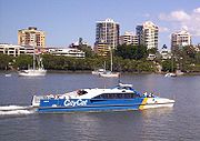
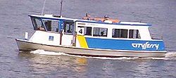
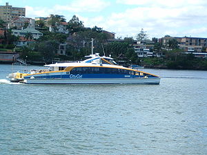
. CityCat uses catamarans, while the area covered by the CityFerry service differs in that it is smaller with stops spaced closer together, and is operated with 12 monohull ferries, varying slightly in appearance from one another.
Unusually, the CityCat's busiest day is actually Sunday. Many people and visitors use it as a very inexpensive way to sightsee.
Taxis
Two cab companies operate in Brisbane: Yellow Cabs (whose vehicles are painted orange), and Black and White Cabs. Both companies offer same rate service (regulated by the government) and pick up passengers from anywhere in the metropolitan and regional areas of Brisbane via bookings or permanent cab ranksTaxi stand
A taxicab stand is a queue area on a street or on private property where taxicabs line up to wait for passengers.-How stands work:...
. As well as standard taxis, both provide Maxi-Taxis designed to fit up to 10 people, and also have disability access, as well as luxury vehicles (Silver Service for Yellow, Business Class for Black and White). All cabs now are also fitted with GPS tracking systems for driver location and EFTPOS
EFTPOS
EFTPOS is the general term used for debit card based systems used for processing transactions through terminals at points of sale. In Australia and New Zealand it is also the brand name of the specific system used for such payments...
debit/credit card facilities.
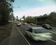
Roads
Brisbane's road system was planned around large, spacious suburban areas. Dense suburbs now rely on several main road corridors that split through and between these areas and provide the only link to the CBD and other areas of Brisbane. Logan RoadLogan Road, Brisbane
Logan Road is a major road in Brisbane, Queensland. It runs 16 km from Springwood to Woolloongabba, with most of the route signed as state route 95...
, Moggill Road
Moggill Road
Moggill Road is a major road in Brisbane. It goes under the 32 number. It starts at the Moggill Ferry in Moggill and finishes at High Street at Toowong.It stretches 27 kilometers...
, Old Cleveland Road and Gympie Road
Gympie Road, Brisbane
Gympie Road is a major road in the northern suburbs of Brisbane, Queensland, Australia. The road forms part of the main road route from the Brisbane Central Business District to the northern suburbs, Sunshine Coast and east coast of Queensland....
are but a few of these multi-lane corridors that come out of the CBD and snake through the suburbs. As a result, traffic congestion
Traffic congestion
Traffic congestion is a condition on road networks that occurs as use increases, and is characterized by slower speeds, longer trip times, and increased vehicular queueing. The most common example is the physical use of roads by vehicles. When traffic demand is great enough that the interaction...
has become a major problem and it was the promise of a new underground road system, nicknamed TransApex
TransApex
TransApex is a transport plan devised by the former Brisbane Lord Mayor Campbell Newman to connect existing motorways and major arterial roads with new transport links and divert cross-city traffic out of the Brisbane CBD. The plan is currently being delivered by Brisbane City Council at an...
, that helped former Lord Mayor Campbell Newman
Campbell Newman
Campbell Kevin Thomas Newman is the leader of the Liberal National Party of Queensland. He was the 15th Lord Mayor of Brisbane from 2004 to 2011....
win the 2004 local government election.
Inner City Bypass
M3 Inner City Bypass is a major motorway standard road in Brisbane, Australia. The 4.5km bypass is north of the city. Bypassing the Brisbane central business district, it connects Brisbane’s Pacific Motorway and Go Between Bridge at Hale Street to Kingsford Smith Drive, the Clem Jones Tunnel and...
, Clem Jones Tunnel, and the future Airport Link
Airport Link, Brisbane
The Airport Link is a tunnelled motorway grade road which is under construction in the northern suburbs of Brisbane, Queensland, Australia. It will connect the Brisbane central business district and the Clem Jones Tunnel to the East-West Arterial Road which leads to the Brisbane Airport...
are intended to help to circulate traffic away from the inner-city areas and main roads via limited-access roads above the ground, and tunnels below that have higher speed limits and exits to particular suburbs. Existing high speed cross-suburban motorways such as the Western Freeway, Centenary Freeway
Centenary Freeway, Brisbane
The M5 is a motorway in the western suburbs of Brisbane, Australia.It starts as a two-lane arterial road at Yamanto, travelling to Springfield, where it becomes a two-lane highway and travels across the M2 Logan Motorway at Ellen Grove and ends at Kenmore where it changes its name to the M5...
, Pacific Motorway
Pacific Motorway
The Pacific Motorway is a 100 km long motorway in Australia between Brisbane, Queensland, and the New South Wales-Queensland border at Tweed Heads. The motorway starts at Coronation Drive at Milton in Brisbane, and from 2008 links the Tweed Heads bypass in New South Wales...
and Gateway Motorway
Gateway Motorway
The Gateway Motorway is a major motorway in Brisbane, Queensland, Australia. The Gateway Bridge is owned and operated by Queensland Motorways....
provide alternative routes to main roads and connect up to main highways and other arterial roads. Other tunnels are also being planned to link all the various motorways in Brisbane together as part of TransApex
TransApex
TransApex is a transport plan devised by the former Brisbane Lord Mayor Campbell Newman to connect existing motorways and major arterial roads with new transport links and divert cross-city traffic out of the Brisbane CBD. The plan is currently being delivered by Brisbane City Council at an...
, but only two have been scheduled for completion within the next decade.
In total, the twisting Brisbane River
Brisbane River
The Brisbane River is the longest river in south east Queensland, Australia, and flows through the city of Brisbane, before emptying into Moreton Bay. John Oxley was the first European to explore the river who named it after the Governor of New South Wales, Thomas Brisbane in 1823...
is crossed by seven road bridges, a road tunnel, three railway bridges, three pedestrian bridges and a dedicated bus, cycle and pedestrian bridge. Route signage is achieved by means of a system of Metroad
Metroad
Metroads are the primary road routes serving the Sydney and Brisbane metropolitan areas in Australia. The Metroads form a network of radial and circumferential routes throughout the city, lengths of some of which are of freeway grade.-History:...
s, consisting of the most important arterial roads in metropolitan Brisbane including most motorways, and less important State Routes. Multiple freeways connect Brisbane to other cities, including the Pacific Motorway
Pacific Motorway
The Pacific Motorway is a 100 km long motorway in Australia between Brisbane, Queensland, and the New South Wales-Queensland border at Tweed Heads. The motorway starts at Coronation Drive at Milton in Brisbane, and from 2008 links the Tweed Heads bypass in New South Wales...
, the Bruce Highway
Bruce Highway
The Bruce Highway is a major highway in Queensland, Australia. Commencing in the state capital, Brisbane, it passes through areas close to the eastern coast to Cairns in Far North Queensland. The route is a part of the Australian National Highway and also part of Highway 1...
and the Ipswich Motorway
Ipswich Motorway
The M7 runs from the junction of Ipswich Road and Granard Road to the M2 Logan Motorway interchange. It is then signed M2 until the junction of the Warrego Highway and the Cunningham Highway between Brisbane and Ipswich in South East Queensland, Australia.It initially passes through the suburbs of...
, all of which are part of the National Highway System
National Highway (Australia)
thumb|right|150px|The National Highway Shield in NSW, QLD, WA, NT & TAS.The National Highway is a system of roads connecting all the States and Territories of Australia, and is the major network of highways connecting Australia's largest and most important cities.The National Highway was...
. Brisbane is approximately 1,000 km away from Sydney
Sydney
Sydney is the most populous city in Australia and the state capital of New South Wales. Sydney is located on Australia's south-east coast of the Tasman Sea. As of June 2010, the greater metropolitan area had an approximate population of 4.6 million people...
, the closest major capital city.
Airports

Brisbane Airport
Brisbane Airport is the sole passenger airport serving Brisbane and the third busiest in Australia, after Melbourne and Sydney Airports. Brisbane Airport has won many awards. Located in the suburb with the same name, the airport serves the city of Brisbane and the surrounding metropolitan area...
, owned by the Brisbane Airport Corporation Limited and located north-east of the city, is the biggest airport in Australia in terms of land size. Brisbane Airport is the third busiest airport in the country behind Sydney and Melbourne Airports respectively. Separated into domestic and international terminals, Brisbane Airport has frequent passenger and freight flights, providing direct flights to every capital city in Australia as well as most destinations in Asia
Asia
Asia is the world's largest and most populous continent, located primarily in the eastern and northern hemispheres. It covers 8.7% of the Earth's total surface area and with approximately 3.879 billion people, it hosts 60% of the world's current human population...
, Oceania
Oceania
Oceania is a region centered on the islands of the tropical Pacific Ocean. Conceptions of what constitutes Oceania range from the coral atolls and volcanic islands of the South Pacific to the entire insular region between Asia and the Americas, including Australasia and the Malay Archipelago...
, and the Middle East
Middle East
The Middle East is a region that encompasses Western Asia and Northern Africa. It is often used as a synonym for Near East, in opposition to Far East...
. Virgin Australia, the second largest airline in Australia, is headquartered in Brisbane, while other major airlines Qantas
Qantas
Qantas Airways Limited is the flag carrier of Australia. The name was originally "QANTAS", an initialism for "Queensland and Northern Territory Aerial Services". Nicknamed "The Flying Kangaroo", the airline is based in Sydney, with its main hub at Sydney Airport...
and Jetstar Airways
Jetstar Airways
Jetstar Airways is an Australian low-cost airline headquartered in Melbourne, Australia. It is a subsidiary of Qantas, created in response to the threat posed by low-cost airline Virgin Blue...
both fly from Brisbane Airport
Brisbane Airport
Brisbane Airport is the sole passenger airport serving Brisbane and the third busiest in Australia, after Melbourne and Sydney Airports. Brisbane Airport has won many awards. Located in the suburb with the same name, the airport serves the city of Brisbane and the surrounding metropolitan area...
.
The Airtrain
AirTrain (Brisbane)
Airtrain is the privately owned commuter railway line that extends 13.0 km northeast from Brisbane , the state capital of Queensland, Australia, to the Brisbane Airport at both its separate International and Domestic terminals.The line is carried on an elevated prestressed concrete viaduct...
provides a link between the Domestic and International Terminals at Brisbane Airport and the city, taking approximately 20 minutes to travel from Central Station
Central railway station, Brisbane
Central railway station is, as the name suggests, the central railway station for the Queensland Rail City network in the Brisbane central business district, the state capital of Queensland, Australia...
to the Airport stations.
Archerfield Airport
Archerfield Airport
Archerfield Airport is a small airport located 7 1/2 miles at Archerfield in the south west of Brisbane, Queensland, Australia. For some time it was the primary airport in Brisbane. During World War II it was used as a Royal Australian Air Force station. Airport traffic peaked in the 1980s...
, located in Brisbane's southern suburbs, caters to general aviation
General aviation
General aviation is one of the two categories of civil aviation. It refers to all flights other than military and scheduled airline and regular cargo flights, both private and commercial. General aviation flights range from gliders and powered parachutes to large, non-scheduled cargo jet flights...
. Other local airports can be found at Caboolture
Caboolture, Queensland
Caboolture is an urban centre approximately north of Brisbane, the state capital of Queensland, Australia. Caboolture is considered to be the northernmost urban area of the greater Brisbane metropolitan region within South East Queensland, and it marks the end of the Brisbane suburban commuter...
and Redcliffe
Redcliffe
Redcliffe City is a municipal location north-northeast of Brisbane, the state capital of Queensland, Australia. Also known as "the Redcliffe peninsula", the area covers the suburbs of Clontarf, Kippa-Ring, Margate, Newport, Redcliffe, Rothwell, Scarborough and Woody Point.Redcliffe is home...
.
Seaports
Port of Brisbane
Port of Brisbane is the shipping port of Brisbane, on the east coast of Australia. It is located in the lower reaches of the Brisbane River on reclaimed land that was once called Fisherman Islands at the mouth of the river. It currently is the third busiest port in Australia and the nation's...
is on the lower reaches of the Brisbane River and on Fisherman's Island at the river's mouth; it is the 3rd most important port in Australia for value of goods. Container freight
Intermodal container
An intermodal container is a standardized reusable steel box used for the safe, efficient and secure storage and movement of materials and products within a global containerized intermodal freight transport system...
, sugar
Sugar
Sugar is a class of edible crystalline carbohydrates, mainly sucrose, lactose, and fructose, characterized by a sweet flavor.Sucrose in its refined form primarily comes from sugar cane and sugar beet...
, grain
GRAIN
GRAIN is a small international non-profit organisation that works to support small farmers and social movements in their struggles for community-controlled and biodiversity-based food systems. Our support takes the form of independent research and analysis, networking at local, regional and...
, coal
Coal
Coal is a combustible black or brownish-black sedimentary rock usually occurring in rock strata in layers or veins called coal beds or coal seams. The harder forms, such as anthracite coal, can be regarded as metamorphic rock because of later exposure to elevated temperature and pressure...
and bulk liquids are the major exports. Most of the port facilities are less than three decades old, and some are built on reclaimed mangrove
Mangrove
Mangroves are various kinds of trees up to medium height and shrubs that grow in saline coastal sediment habitats in the tropics and subtropics – mainly between latitudes N and S...
s and wetlands. Historically, Brisbane's port facilities were located as far upstream as the central business district
Central business district
A central business district is the commercial and often geographic heart of a city. In North America this part of a city is commonly referred to as "downtown" or "city center"...
.
The economic region near the river's mouth including the port, airport and refineries is known as the Australia TradeCoast
Australia TradeCoast
Australia TradeCoast is an economic development area of Brisbane, the state capital of Queensland, Australia.The concept of branding and promoting the empty space around Brisbane's port and airport, following many years of Government reports and soul-searching on what might be done with the...
.
Future infrastructure
Brisbane's population growth has seen great strains placed upon South East Queensland's transport system. The State Government and Brisbane City Council have responded with infrastructure plans and increased funding for transportation projects, such as the South East Queensland Infrastructure Plan and ProgramSouth East Queensland Infrastructure Plan and Program
The South East Queensland Infrastructure Plan and Program 2010–2031 is produced by the Queensland Department of Infrastructure and Planning and outlines estimated infrastructure investment across South East Queensland Australia to 2031. It represents a long-term commitment to infrastructure...
. Most of the focus has been placed on expanding current road infrastructure, particularly tunnels and bypasses, as well as improving the public transport system.