

Topological map
Encyclopedia
Cartography
Cartography is the study and practice of making maps. Combining science, aesthetics, and technique, cartography builds on the premise that reality can be modeled in ways that communicate spatial information effectively.The fundamental problems of traditional cartography are to:*Set the map's...
and geology
Geology
Geology is the science comprising the study of solid Earth, the rocks of which it is composed, and the processes by which it evolves. Geology gives insight into the history of the Earth, as it provides the primary evidence for plate tectonics, the evolutionary history of life, and past climates...
, a topological
Topology
Topology is a major area of mathematics concerned with properties that are preserved under continuous deformations of objects, such as deformations that involve stretching, but no tearing or gluing...
map
Map
A map is a visual representation of an area—a symbolic depiction highlighting relationships between elements of that space such as objects, regions, and themes....
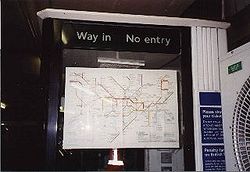
is one that has been simplified so that only vital information remains and unnecessary detail has been removed. These maps lack scale, and distance and direction are subject to change and variation, but the relationship between points is maintained. A good example is the tube map
Tube map
The Tube map is a schematic transit map representing the lines and stations of London's rapid transit railway systems, namely the London Underground , the Docklands Light Railway and London Overground....
of the London Underground
London Underground
The London Underground is a rapid transit system serving a large part of Greater London and some parts of Buckinghamshire, Hertfordshire and Essex in England...
.
The name topological map is derived from topology
Topology
Topology is a major area of mathematics concerned with properties that are preserved under continuous deformations of objects, such as deformations that involve stretching, but no tearing or gluing...
, the branch of mathematics that studies the properties of objects that do not change as the object is deformed, much as the tube map retains useful information despite bearing little resemblance to the actual layout of the underground system.
Not to be confused with a topographic map
Topographic map
A topographic map is a type of map characterized by large-scale detail and quantitative representation of relief, usually using contour lines in modern mapping, but historically using a variety of methods. Traditional definitions require a topographic map to show both natural and man-made features...
.
See also
- Aerial photographyAerial photographyAerial photography is the taking of photographs of the ground from an elevated position. The term usually refers to images in which the camera is not supported by a ground-based structure. Cameras may be hand held or mounted, and photographs may be taken by a photographer, triggered remotely or...
- Animated mappingAnimated mappingAnimated mapping is the application of animation, either computer or video, to add a temporal component to a map displaying change in some dimension. Most commonly the change is shown over time, generally at a greatly changed scale...
- British Cartographic SocietyBritish Cartographic SocietyThe British Cartographic Society is an association of individuals and organisations dedicated to exploring and developing the world of maps. It is a registered charity...
- CartogramCartogramA cartogram is a map in which some thematic mapping variable – such as travel time or Gross National Product – is substituted for land area or distance. The geometry or space of the map is distorted in order to convey the information of this alternate variable...
- Cartographic relief depictionCartographic relief depictionTerrain or relief is an essential aspect of physical geography, and as such its portrayal presents a central problem in cartography, and more recently GIS and 3D Visualization....
- Cartographic generalizationCartographic generalizationCartographic generalization is the method whereby information is selected and represented on a map in a way that adapts to the scale of the display medium of the map, not necessarily preserving all intricate geographical or other cartographic details...
- Contour lineContour lineA contour line of a function of two variables is a curve along which the function has a constant value. In cartography, a contour line joins points of equal elevation above a given level, such as mean sea level...
- Critical cartographyCritical cartographyCritical Cartography is a set of new mapping practices and theoretical critique grounded in critical theory. It differs from academic cartography in that it links geographic knowledge with power, and thus is political...
- Digital Cadastral DataBaseDigital Cadastral DataBaseDigital Cadastral DataBase is a computerised map or 'spatial' location showing property boundaries normally in relation to adjoining and other close properties or parcels of land. Commonly used as a basic layer of data used in map based computer programs that gives an outline of the legal...
- Fantasy mapFantasy mapA fantasy map is type of map design that is a visual representation of an imaginary or fictional geography. While some fantasy maps accompany works of fiction and are considered fictional maps, fantasy maps are created to show imaginary places and are not necessarily included in works of literary...
- Figure-ground in map designFigure-ground in map designAn effectively designed map is one in which the intended message is clearly communicated to the map user. By employing the concept of figure-ground, a viewer can easily distinguish between the main figure on a map and the background information...
- Four color theoremFour color theoremIn mathematics, the four color theorem, or the four color map theorem states that, given any separation of a plane into contiguous regions, producing a figure called a map, no more than four colors are required to color the regions of the map so that no two adjacent regions have the same color...
- GazetteerGazetteerA gazetteer is a geographical dictionary or directory, an important reference for information about places and place names , used in conjunction with a map or a full atlas. It typically contains information concerning the geographical makeup of a country, region, or continent as well as the social...
- GeocodeGeocodeGEOCODE is a standardized all-natural number representation format specification for geospatial coordinate measurements that provide details of the exact location of geospatial point at, below, or above the surface of the earth at a specified moment of time.Geocode is patented under US Patents...
- Geographic Information SystemGeographic Information SystemA geographic information system, geographical information science, or geospatial information studies is a system designed to capture, store, manipulate, analyze, manage, and present all types of geographically referenced data...
(GIS) - GeovisualizationGeovisualizationGeovisualization, short for Geographic Visualization, refers to a set of tools and techniques supporting geospatial data analysis through the use of interactive visualization....
- Here be dragonsHere be dragons"Here be dragons" is a phrase used to denote dangerous or unexplored territories, in imitation of the medieval practice of putting sea serpents and other mythological creatures in uncharted areas of maps.-History:...
- IsostasyIsostasyIsostasy is a term used in geology to refer to the state of gravitational equilibrium between the earth's lithosphere and asthenosphere such that the tectonic plates "float" at an elevation which depends on their thickness and density. This concept is invoked to explain how different topographic...
- Japanese map symbolsJapanese map symbolsThis is a list of symbols appearing on Japanese maps. These symbols are called in the Japanese language.symbolmeaningillustrationsymbolmeaningillustrationMunicipal building Municipal building...
- List of cartographers
- Locator mapLocator mapA locator map, sometimes referred to simply as a locator, is typically a simple map used in cartography to show the location of a particular geographic area within its larger and presumably more familiar context...
- Map projectionMap projectionA map projection is any method of representing the surface of a sphere or other three-dimensional body on a plane. Map projections are necessary for creating maps. All map projections distort the surface in some fashion...
- National Geospatial-Intelligence AgencyNational Geospatial-Intelligence AgencyThe National Geospatial-Intelligence Agency is an agency of the federal government of the United States with the primary mission of collecting, analyzing and distributing geospatial intelligence in support of national security. NGA was formerly known as the National Imagery and Mapping Agency ...
- OpenStreetMapOpenStreetMapOpenStreetMap is a collaborative project to create a free editable map of the world. Two major driving forces behind the establishment and growth of OSM have been restrictions on use or availability of map information across much of the world and the advent of inexpensive portable GPS devices.The...
, a free project mapping the world's roads using GPSGlobal Positioning SystemThe Global Positioning System is a space-based global navigation satellite system that provides location and time information in all weather, anywhere on or near the Earth, where there is an unobstructed line of sight to four or more GPS satellites... - OrthophotoOrthophotoAn orthophoto, orthophotograph or orthoimage is an aerial photograph geometrically corrected such that the scale is uniform: the photo has the same lack of distortion as a map...
- Pictorial mapsPictorial mapsPictorial maps are a category of maps that are also loosely called illustrated maps, panoramic maps, perspective maps, bird’s-eye view maps and Geopictorial maps amongst others. In contrast to the regular road map, Atlas or topographic cartography, pictorial maps depict a given territory with a...
- Planetary cartographyPlanetary cartographyPlanetary Cartography includes all cartographic materials produced for objects with solid surfaces external to the Earth. This can include any spatially mapped characteristic for extraterrestrial surfaces. Also can be referred to as the Cartography of Extraterrestrial Objects...
- Point of BeginningPoint of BeginningThe point of beginning is a surveyor's mark at the beginning location for the wide-scale surveying of land.An example is the Beginning Point of the U.S. Public Land Survey that led to the opening of the Northwest Territory, and is the starting point of the surveys of almost all other lands to the...
- Sea levelSea levelMean sea level is a measure of the average height of the ocean's surface ; used as a standard in reckoning land elevation...
- Terra incognitaTerra incognitaTerra incognita or terra ignota is a term used in cartography for regions that have not been mapped or documented. The expression is believed to be first seen in Ptolemy’s Geography circa 150 CE...