
Tone River
Encyclopedia
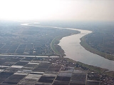
The is a river in the Kantō region
of Japan
. It is 322 kilometres (200.1 mi) in length (the second longest in Japan after the Shinano
) and has a drainage area of 16840 square kilometres (6,502 sq mi) (largest in Japan). It is nicknamed ; Bandō is an obsolete alias of Kanto, and Tarō is a popular given name for the eldest son).
It is regarded as one of the "Three Greatest Rivers" of Japan (the other two are the Yoshino
in Shikoku
and the Chikugo
in Kyūshū
).
and Niigata
Prefectures. It gathers tributaries and pours into the Pacific Ocean
at Choshi
city in Chiba Prefecture
. The Edo River
branches away from the river and flows into Tokyo Bay
.
Major tributaries of the river include the Agatsuma
, Watarase
, Kinu, Omoi, and Kokai rivers.
The river originally flowed into Tokyo Bay, and tributaries like the Watarase
and Kinu had independent river systems. For the sake of water transportation and flood control, extensive construction began in the 17th century, when the Kanto region became the political center of Japan. The present route of the river was determined in the mass during the Meiji period
. Its vast watershed is thus largely artificial.
 The river was important transport until the advent of the railway in the 19th century. It carried not only local products like soy sauce
from Choshi
, but also products from the Tohoku region
, in order to save time and to avoid risk in the open sea.
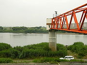
Today the river has several dam
s to supply water for more than 30 million inhabitants of the Tokyo
metropolitan area.
) over a 12 km stretch. The river provides some of the best white water rafting
and kayaking
in Japan and played host to the rafting world cup in spring 2007. The snow melt swells the river to grade 4 in Spring; in the Summer it is a gentle grade 2. The MomijiKyo section has 7 grade 3-4 rapids in 1 km and is 12 km long in total.
Kanto region
The is a geographical area of Honshu, the largest island of Japan. The region includes the Greater Tokyo Area and encompasses seven prefectures: Gunma, Tochigi, Ibaraki, Saitama, Tokyo, Chiba, and Kanagawa. Within its boundaries, slightly more than 40 percent of the land area is the Kantō Plain....
of Japan
Japan
Japan is an island nation in East Asia. Located in the Pacific Ocean, it lies to the east of the Sea of Japan, China, North Korea, South Korea and Russia, stretching from the Sea of Okhotsk in the north to the East China Sea and Taiwan in the south...
. It is 322 kilometres (200.1 mi) in length (the second longest in Japan after the Shinano
Shinano River
The Shinano River is the longest and largest river in Japan. It flows from Nagano Prefecture to Niigata Prefecture. It is called the Chikuma River in Nagano Prefecture....
) and has a drainage area of 16840 square kilometres (6,502 sq mi) (largest in Japan). It is nicknamed ; Bandō is an obsolete alias of Kanto, and Tarō is a popular given name for the eldest son).
It is regarded as one of the "Three Greatest Rivers" of Japan (the other two are the Yoshino
Yoshino River
The Yoshino River is a river on the island of Shikoku, Japan. It is 194 km long and has a watershed of 3,750 km². It is the second longest river in Shikoku , and is the only river whose watershed spreads over the four prefectures of the island.It is regarded as one of the three greatest rivers of...
in Shikoku
Shikoku
is the smallest and least populous of the four main islands of Japan, located south of Honshū and east of the island of Kyūshū. Its ancient names include Iyo-no-futana-shima , Iyo-shima , and Futana-shima...
and the Chikugo
Chikugo River
The flows through Kumamoto, Ōita, Fukuoka and Saga prefectures in Japan. With a total length of , it is the longest river on Kyūshū. It flows from Mount Aso and empties into the Ariake Sea. It is also nicknamed "Chikushijirō"...
in Kyūshū
Kyushu
is the third largest island of Japan and most southwesterly of its four main islands. Its alternate ancient names include , , and . The historical regional name is referred to Kyushu and its surrounding islands....
).
Geography
The source of the river is Mount Ōminakami (大水上山), which straddles the border between GunmaGunma Prefecture
is a prefecture of Japan located in the northwest corner of the Kantō region on Honshu island. Its capital is Maebashi.- History :The remains of a Paleolithic man were found at Iwajuku, Gunma Prefecture, in the early 20th century and there is a public museum there.Japan was without horses until...
and Niigata
Niigata Prefecture
is a prefecture of Japan located on the island of Honshū on the coast of the Sea of Japan. The capital is the city of Niigata. The name "Niigata" literally means "new lagoon".- History :...
Prefectures. It gathers tributaries and pours into the Pacific Ocean
Pacific Ocean
The Pacific Ocean is the largest of the Earth's oceanic divisions. It extends from the Arctic in the north to the Southern Ocean in the south, bounded by Asia and Australia in the west, and the Americas in the east.At 165.2 million square kilometres in area, this largest division of the World...
at Choshi
Choshi, Chiba
is a city located on the Pacific Ocean coast of Chiba Prefecture, Japan. It is the easternmost city in the Greater Tokyo Area. The easternmost point in the Greater Tokyo Area is Cape Inubō....
city in Chiba Prefecture
Chiba Prefecture
is a prefecture of Japan located in the Kantō region and the Greater Tokyo Area. Its capital is Chiba City.- History :Chiba Prefecture was established on June 15, 1873 with the merger of Kisarazu Prefecture and Inba Prefecture...
. The Edo River
Edo River
thumb|The Edo River in [[Nagareyama, Chiba]] PrefectureThe is a river in the Kantō region of Japan. It splits from the Tone River at the northernmost tip of Narita City, crosses through Nagareyama and Matsudo, and empties into Tokyo Bay at Ichikawa. The Edo forms the borders between Tokyo, Chiba,...
branches away from the river and flows into Tokyo Bay
Tokyo Bay
is a bay in the southern Kantō region of Japan. Its old name was .-Geography:Tokyo Bay is surrounded by the Bōsō Peninsula to the east and the Miura Peninsula to the west. In a narrow sense, Tokyo Bay is the area north of the straight line formed by the on the Miura Peninsula on one end and on...
.
Major tributaries of the river include the Agatsuma
Agatsuma River
The is a river in the Kantō region of Japan. It is 76.22 km in length and has a drainage area of 1,366 km². Located entirely within Gunma Prefecture, it is one of the prefecture's major rivers. It is also a major tributary of the Tone River.- Geography :...
, Watarase
Watarase River
The is a major river in the northern Kantō region of Japan. A tributary of the Tone River, it is 106.7 km in length and drains an area of 2,621 km². Its source is at Mount Sukai on the boundary of the city of Nikkō in Tochigi Prefecture and it empties into the Tone at the boundary of the...
, Kinu, Omoi, and Kokai rivers.
History
The river was once known for its uncontrollable nature, and its route changed whenever floods occurred. It is hard to trace the ancient route of the river.The river originally flowed into Tokyo Bay, and tributaries like the Watarase
Watarase River
The is a major river in the northern Kantō region of Japan. A tributary of the Tone River, it is 106.7 km in length and drains an area of 2,621 km². Its source is at Mount Sukai on the boundary of the city of Nikkō in Tochigi Prefecture and it empties into the Tone at the boundary of the...
and Kinu had independent river systems. For the sake of water transportation and flood control, extensive construction began in the 17th century, when the Kanto region became the political center of Japan. The present route of the river was determined in the mass during the Meiji period
Meiji period
The , also known as the Meiji era, is a Japanese era which extended from September 1868 through July 1912. This period represents the first half of the Empire of Japan.- Meiji Restoration and the emperor :...
. Its vast watershed is thus largely artificial.
Use
Soy sauce
Soy sauce is a condiment produced by fermenting soybeans with Aspergillus oryzae or Aspergillus sojae molds, along with water and salt...
from Choshi
Choshi, Chiba
is a city located on the Pacific Ocean coast of Chiba Prefecture, Japan. It is the easternmost city in the Greater Tokyo Area. The easternmost point in the Greater Tokyo Area is Cape Inubō....
, but also products from the Tohoku region
Tohoku region
The is a geographical area of Japan. The region occupies the northeastern portion of Honshu, the largest island of Japan. The region consists of six prefectures : Akita, Aomori, Fukushima, Iwate, Miyagi and Yamagata....
, in order to save time and to avoid risk in the open sea.
Today the river has several dam
Dam
A dam is a barrier that impounds water or underground streams. Dams generally serve the primary purpose of retaining water, while other structures such as floodgates or levees are used to manage or prevent water flow into specific land regions. Hydropower and pumped-storage hydroelectricity are...
s to supply water for more than 30 million inhabitants of the Tokyo
Tokyo
, ; officially , is one of the 47 prefectures of Japan. Tokyo is the capital of Japan, the center of the Greater Tokyo Area, and the largest metropolitan area of Japan. It is the seat of the Japanese government and the Imperial Palace, and the home of the Japanese Imperial Family...
metropolitan area.
Rafting and kayaking
Minakami Onsen in Gunma Prefecture, is the source for the Tone River and during the Spring snow melt period, April - June, the river provides consistent grade 4 rapids (on the International Scale of River DifficultyInternational Scale of River Difficulty
The International Scale of River Difficulty is a standardized scale used to rate the safety of a stretch of river, or a single rapid. The grade reflects the technical difficulty and skill level required associated with the section of river...
) over a 12 km stretch. The river provides some of the best white water rafting
Rafting
Rafting or white water rafting is a challenging recreational outdoor activity using an inflatable raft to navigate a river or other bodies of water. This is usually done on white water or different degrees of rough water, in order to thrill and excite the raft passengers. The development of this...
and kayaking
Kayaking
Kayaking is the use of a kayak for moving across water. Kayaking and canoeing are also known as paddling. Kayaking is distinguished from canoeing by the sitting position of the paddler and the number of blades on the paddle...
in Japan and played host to the rafting world cup in spring 2007. The snow melt swells the river to grade 4 in Spring; in the Summer it is a gentle grade 2. The MomijiKyo section has 7 grade 3-4 rapids in 1 km and is 12 km long in total.