
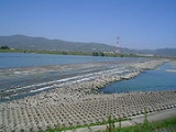
Yoshino River
Encyclopedia

River
A river is a natural watercourse, usually freshwater, flowing towards an ocean, a lake, a sea, or another river. In a few cases, a river simply flows into the ground or dries up completely before reaching another body of water. Small rivers may also be called by several other names, including...
on the island of Shikoku
Shikoku
is the smallest and least populous of the four main islands of Japan, located south of Honshū and east of the island of Kyūshū. Its ancient names include Iyo-no-futana-shima , Iyo-shima , and Futana-shima...
, Japan
Japan
Japan is an island nation in East Asia. Located in the Pacific Ocean, it lies to the east of the Sea of Japan, China, North Korea, South Korea and Russia, stretching from the Sea of Okhotsk in the north to the East China Sea and Taiwan in the south...
. It is 194 km long and has a watershed of 3,750 km². It is the second longest river in Shikoku (slightly shorter than the Shimanto
Shimanto River
The is a river in western Kōchi Prefecture, Japan. 196 km in length, it has a watershed of 2,270 km².Since the river is remote from major cities and does not have any dams, it is sometimes referred to as "the last clear stream of Japan". Fishing and production of nori is a thriving...
), and is the only river whose watershed spreads over the four prefectures of the island.
It is regarded as one of the three greatest rivers of Japan along with the Tone
Tone River
The is a river in the Kantō region of Japan. It is in length and has a drainage area of...
and the Chikugo
Chikugo River
The flows through Kumamoto, Ōita, Fukuoka and Saga prefectures in Japan. With a total length of , it is the longest river on Kyūshū. It flows from Mount Aso and empties into the Ariake Sea. It is also nicknamed "Chikushijirō"...
, and is nicknamed Shikoku Saburō (四国三郎; Saburō is a popular given name for a third son).
The Yoshino rises from Mount Kamegamori (瓶ケ森) in Ino
Ino, Kochi
is a town located in Agawa District, Kōchi, Japan. The town is famous for the production of .On October 1, 2004 the village of Gohoku, also from Agawa District, and the village of Hongawa, from Tosa District, were merged into Ino, increasing its size by almost a factor of five.As of the merger with...
, Kochi Prefecture
Kochi Prefecture
is a prefecture of Japan located on the south coast of Shikoku. The capital is the city of Kōchi.- History :Prior to the Meiji Restoration, Kōchi was known as Tosa Province and was controlled by the Chosokabe clan in the Sengoku period and the Yamauchi family during the Edo period.- Geography...
and flows to the east. In Otoyo
Otoyo, Kochi
is a town located in Nagaoka District, Kōchi, Japan. It is the only municipality in Shikoku where over 50% of the population is aged over 65.-Geography:...
it turns to the north and crosses the Shikoku Mountains. The gorge, named Ōboke Koboke, is a famous tourist attraction of Shikoku. In Ikeda
Ikeda, Tokushima
was a town located in Miyoshi District, Tokushima, Japan.On March 1, 2006 Ikeda was merged with the towns of Ikawa, Mino and Yamashiro, and the villages of Higashiiyayama and Nishiiyayama, all from Miyoshi District, to form the new city of Miyoshi....
, Tokushima Prefecture
Tokushima Prefecture
is a prefecture of Japan located on Shikoku island. The capital is the city of Tokushima.- Tokushima Prefecture and Myodo Prefecture :Long ago, Tokushima City belonged to a region known as Myōdō-gun...
it turns to the east again and pours into the sea at the north of Tokushima city
Tokushima, Tokushima
is the capital city of Tokushima Prefecture on Shikoku island in Japan.As of May 1, 2011, the city had an estimated population of 263,372, with 114,325 households, and a population density of 1,377.25 persons per km². Its total area is 191.23 km²....
. Its major tributaries include Ananai, Iya, Dōzan, Sadamitsu, and Anabuki.
The river has some "submerged bridges" (潜水橋 Sensuikyō), equivalents of Chinkabashi of the Shimanto, which lack parapets in order not to be washed away by floods. Reconstruction of the Yoshino Daiju Dam (吉野川第十堰 Yoshino-gawa Daijūzeki) near its mouth provoked much controversy among environmentalists.