

The Roads, Miami, Florida
Encyclopedia
The Roads is a neighborhood of Miami in Miami-Dade County
, Florida
, United States
. It is a triangular area located south of SW 11th Street, between SW 12th Avenue and Broadway
(SW Third Avenue), just west of Brickell
.
The Roads is known for its old homes, historic public schools, and its tree-covered streets. The Roads is very close to Downtown
and Brickell, but is a surprisingly quiet neighborhood. It is also a unique neighborhood because it is off the Miami grid, and thus all the streets in The Roads are named roads, instead of streets and avenues, as is the case in the rest of Miami. Since 1986, the Miami Roads Neighborhood Civic Association has worked on a variety of projects to support the neighborhood.
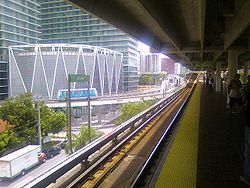
The Roads neighborhood is served by the Miami Metrorail
at the Vizcaya station
to the south and by the Brickell station to the north.
Although the homes in the Roads were originally planned to be affordable for Miamians, homes in the Roads were popular early on and quickly became one of Miami's most prestigious neighborhoods. During the 1970s and 80s, the Roads is said to be the only inner-city neighborhood in Florida that did not fall to urban decay
, and maintained its quality. Today, many of the residents in the Roads are urban professionals who work in neighboring Downtown Miami
and Brickell
.
The Roads is also an entire off-grid plan
section of the city of Miami. The streets and avenues in Miami-Dade County are aligned to a grid, where streets run east-west and avenues run north-south. The roads that run from Broadway to SW 32nd Road are roughly 45 degrees out of alignment with the grid-plan. The avenues running perpendicular to these roads are also 45 degrees out of alignment with their respective avenues coming from the north. The avenues in this section run northeast-southwest rather than the standard north-south that the ones in the rest of the county follow. This causes an abrupt change in numerical designation as they cross SW 12th Avenue (SW 5th Avenue turns west and becomes SW 18th Street, SW 4th Avenue turns west and becomes SW 20th Street, SW 2nd Avenue turns west and becomes SW 22nd Street, etc.) The most well known example of this confusion is when historic Coral Way
being SW 3rd Avenue, makes a 45 degree turn onto SW 22nd Street as it crosses over SW 12th Avenue.
 The Roads is served by Metrobus throughout the area, and by the Miami Metrorail at:
}} Brickell (SW 11th Street and SW 1st Avenue)}} Vizcaya
(SW 32nd Road and U.S. 1
)
Metrorail has stops throughout Miami with connections to Miami International Airport
, all Miami-Dade County bus lines, Tri-Rail
and Amtrak
. The main bus station in Downtown is located next to the Arsht Center at the Adrienne Arsht Center Station.
operates area public schools:
Miami-Dade County, Florida
Miami-Dade County is a county located in the southeastern part of the state of Florida. As of 2010 U.S. Census, the county had a population of 2,496,435, making it the most populous county in Florida and the eighth-most populous county in the United States...
, Florida
Florida
Florida is a state in the southeastern United States, located on the nation's Atlantic and Gulf coasts. It is bordered to the west by the Gulf of Mexico, to the north by Alabama and Georgia and to the east by the Atlantic Ocean. With a population of 18,801,310 as measured by the 2010 census, it...
, United States
United States
The United States of America is a federal constitutional republic comprising fifty states and a federal district...
. It is a triangular area located south of SW 11th Street, between SW 12th Avenue and Broadway
Broadway (Miami)
Broadway is the name given to SW\SE 15th Road in the City of Miami, Florida, United States.It is the south boundary of the Miami Financial District, in Downtown Miami's Brickell neighborhood....
(SW Third Avenue), just west of Brickell
Brickell
Brickell is an urban neighborhood in Miami, Florida, United States. A neighborhood of greater Downtown Miami, Brickell is Miami and South Florida's major financial district.-Background:...
.
The Roads is known for its old homes, historic public schools, and its tree-covered streets. The Roads is very close to Downtown
Downtown Miami
Downtown Miami is an urban residential neighborhood, and the central business district of Miami, Miami-Dade County, and South Florida in the United States...
and Brickell, but is a surprisingly quiet neighborhood. It is also a unique neighborhood because it is off the Miami grid, and thus all the streets in The Roads are named roads, instead of streets and avenues, as is the case in the rest of Miami. Since 1986, the Miami Roads Neighborhood Civic Association has worked on a variety of projects to support the neighborhood.
The Roads neighborhood is served by the Miami Metrorail
Metrorail (Miami)
The Miami Metrorail, officially Metrorail and commonly called the Metro, is the heavy rail rapid transit system of Miami, Florida, United States, serving the Miami metropolitan area. The Metro is operated by Miami-Dade Transit, a departmental agency of Miami-Dade County...
at the Vizcaya station
Vizcaya (Metrorail station)
Vizcaya is a Metrorail station in The Roads neighborhood of Miami, Florida.The station is located near the intersection of Southwest First Avenue and 32nd Road, at the southern junction of I-95 and South Dixie Highway and two blocks southeast of Coral Way...
to the south and by the Brickell station to the north.
History
The Roads, originally called "Brickell Hammock" was designed, platted and developed by Mary Brickell in January 1922 days before her death. Mary Brickell had designed the Roads as a pedestrian-friendly neighborhood, with wide streets with median parkways and roundabouts with native Miami plants. Mary Brickell gave the streets, parkways, sidewalks, and electric lighting to the City of Miami in 1922. All the properties were sold in a single day on February 1, 1923.Although the homes in the Roads were originally planned to be affordable for Miamians, homes in the Roads were popular early on and quickly became one of Miami's most prestigious neighborhoods. During the 1970s and 80s, the Roads is said to be the only inner-city neighborhood in Florida that did not fall to urban decay
Urban decay
Urban decay is the process whereby a previously functioning city, or part of a city, falls into disrepair and decrepitude...
, and maintained its quality. Today, many of the residents in the Roads are urban professionals who work in neighboring Downtown Miami
Downtown Miami
Downtown Miami is an urban residential neighborhood, and the central business district of Miami, Miami-Dade County, and South Florida in the United States...
and Brickell
Brickell
Brickell is an urban neighborhood in Miami, Florida, United States. A neighborhood of greater Downtown Miami, Brickell is Miami and South Florida's major financial district.-Background:...
.
Geography
It is located at 25.756°N 80.205°W, with an elevation 13 feet (4 m), making it one of the higher areas in the city.The Roads is also an entire off-grid plan
Grid plan
The grid plan, grid street plan or gridiron plan is a type of city plan in which streets run at right angles to each other, forming a grid...
section of the city of Miami. The streets and avenues in Miami-Dade County are aligned to a grid, where streets run east-west and avenues run north-south. The roads that run from Broadway to SW 32nd Road are roughly 45 degrees out of alignment with the grid-plan. The avenues running perpendicular to these roads are also 45 degrees out of alignment with their respective avenues coming from the north. The avenues in this section run northeast-southwest rather than the standard north-south that the ones in the rest of the county follow. This causes an abrupt change in numerical designation as they cross SW 12th Avenue (SW 5th Avenue turns west and becomes SW 18th Street, SW 4th Avenue turns west and becomes SW 20th Street, SW 2nd Avenue turns west and becomes SW 22nd Street, etc.) The most well known example of this confusion is when historic Coral Way
Coral Way
Coral Way is a primarily east-west street that begins in the Brickell neighborhood of Downtown, Miami, Florida, United States, ending in Westchester.-Route description:...
being SW 3rd Avenue, makes a 45 degree turn onto SW 22nd Street as it crosses over SW 12th Avenue.
Transportation
}} Brickell (SW 11th Street and SW 1st Avenue)}} Vizcaya
Vizcaya (Metrorail station)
Vizcaya is a Metrorail station in The Roads neighborhood of Miami, Florida.The station is located near the intersection of Southwest First Avenue and 32nd Road, at the southern junction of I-95 and South Dixie Highway and two blocks southeast of Coral Way...
(SW 32nd Road and U.S. 1
U.S. Route 1 in Florida
U.S. Route 1 in Florida runs along the state's east coast from Key West to its crossing of the St. Marys River into Georgia north of Boulogne, and south of Folkston. US 1 was designated through Florida when the U.S. Highway System was established in 1926.US 1 runs in the state of Florida, and...
)
Metrorail has stops throughout Miami with connections to Miami International Airport
Miami International Airport
Miami International Airport , also known as MIA and historically Wilcox Field, is the primary airport serving the South Florida area...
, all Miami-Dade County bus lines, Tri-Rail
Tri-Rail
Tri-Rail is a commuter rail line linking Miami, Fort Lauderdale, and West Palm Beach, Florida, United States. It is run by the South Florida Regional Transportation Authority. The system has 18 stations along the South Florida coast...
and Amtrak
Amtrak
The National Railroad Passenger Corporation, doing business as Amtrak , is a government-owned corporation that was organized on May 1, 1971, to provide intercity passenger train service in the United States. "Amtrak" is a portmanteau of the words "America" and "track". It is headquartered at Union...
. The main bus station in Downtown is located next to the Arsht Center at the Adrienne Arsht Center Station.
Elementary schools
Miami-Dade County Public SchoolsMiami-Dade County Public Schools
Miami-Dade County Public Schools is a public school district serving Miami-Dade County, Florida. Founded in 1885, it is the largest school district in Florida and the Southeastern United States, and the fourth largest in the United States, with a student enrollment of 380,006 as of July 5, 2010...
operates area public schools:
- Southside Elementary School
- Ada Merritt Elementary School
- Riverside Elementary School
Parks
- Shenandoah Park- SW 19th St and SW 22nd Ave
- Simpson Park- (nature preserve) S. Miami Ave and Broadway
- Alice Wainwright Park- (nature preserve) Brickell Ave and the Rickenbacker Causeway
- Southside Park- SW 1st Ave and SW 11th St
- Vizcaya Museum and Gardens- 3251 S Miami Ave