

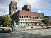
The City Hall Square, Oslo
Encyclopedia
Town square
A town square is an open public space commonly found in the heart of a traditional town used for community gatherings. Other names for town square are civic center, city square, urban square, market square, public square, and town green.Most town squares are hardscapes suitable for open markets,...
located between Oslo City Hall
Oslo City Hall
Oslo City Hall houses the city council, city administration, and art studios and galleries. The construction started in 1931, but was paused by the outbreak of World War II, before the official inauguration in 1950. Its characteristic architecture, artworks and the Nobel Peace Prize ceremony, held...
and the Oslofjord
Oslofjord
The Oslofjord is a bay in the south-east of Norway, stretching from an imaginary line between the Torbjørnskjær and Færder lighthouses and down to Langesund in the south to Oslo in the north....
in Vika
Vika, Oslo
Vika is a neighborhood in the borough Frogner in Oslo, Norway. It is located between the Oslofjord, Aker Brygge, Pipervika, Slottsparken and Oslo City Hall....
, Oslo
Oslo
Oslo is a municipality, as well as the capital and most populous city in Norway. As a municipality , it was established on 1 January 1838. Founded around 1048 by King Harald III of Norway, the city was largely destroyed by fire in 1624. The city was moved under the reign of Denmark–Norway's King...
, Norway
Norway
Norway , officially the Kingdom of Norway, is a Nordic unitary constitutional monarchy whose territory comprises the western portion of the Scandinavian Peninsula, Jan Mayen, and the Arctic archipelago of Svalbard and Bouvet Island. Norway has a total area of and a population of about 4.9 million...
. Previously used as a road and part of European route E18
European route E18
European route E18 runs from Craigavon in the United Kingdom to Saint Petersburg in Russia, passing through Norway, Sweden, and Finland. It is about 1,890 km in length.-United Kingdom:...
, it has since 1994 served as a recreational area. North of the square stands the city hall, to the south the fjord, to the east Akershus Fortress
Akershus Fortress
Akershus Fortress or Akershus Castle is a medieval castle that was built to protect Oslo, the capital of Norway. It has also been used as a prison.- Construction :...
and to the east the former Western Railway Station
Oslo Vestbanestasjon
Oslo West Station or Oslo V, is a former railway station located in Vika in Oslo, Norway. It was the terminus of the Drammen Line between 1872 and 1980, until the Oslo Tunnel opened. The station remained in use until 1989, when all traffic was moved to the new Oslo Central Station...
.
History
Up until the 1920s, the area of PipervikaPipervika
Pipervika is a neighborhood in the borough Sentrum in Oslo, Norway. It is located between the Oslofjord, Akershus Fortress and The City Hall Square. Today the term Pipervika is primarily used for the bay between the fortress and Aker Brygge. This was formerly commonly known as Piperviksbukta...
was dominated by common housing, and was seen by the contemporary elite as an area with low housing standard, poor hygiene and lack of moral standards. Plans for the new city hall started in 1915, and in 1921 the Parliament of Norway passed legislation allowing expropriation
Eminent domain
Eminent domain , compulsory purchase , resumption/compulsory acquisition , or expropriation is an action of the state to seize a citizen's private property, expropriate property, or seize a citizen's rights in property with due monetary compensation, but without the owner's consent...
of parts of Pipervika to build a city hall and a square. An architectural competition announced in 1916 was won by the architects Arnstein Arneberg
Arnstein Arneberg
Arnstein Rynning Arneberg was a Norwegian architect. He was active as an architect for 50 years and is often considered the leading architect in Norway of his time. -Background:...
and Magnus Poulsson
Magnus Poulsson
Magnus Poulsson was a Norwegian architect.-Biography:Magnus Poulsson was born in Drammen, Buskerud county, Norway. His parents were Søren Anton Poulsson and Ina Bolette Jørgensen...
. Their plan involved paving the square with granite
Granite
Granite is a common and widely occurring type of intrusive, felsic, igneous rock. Granite usually has a medium- to coarse-grained texture. Occasionally some individual crystals are larger than the groundmass, in which case the texture is known as porphyritic. A granitic rock with a porphyritic...
, and making it an urban open space, instead of a park.
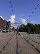
Highway and tunnel
Since 10 October 1875, the square had been part of the Vestbanen Line of the Oslo Tramway. It remained until 1961. Also the Oslo Port Line opened on 13 November 1907. The square ended up as a six-lane highway that functioned as the main east–west road through Oslo, and was part of European Route E18European route E18
European route E18 runs from Craigavon in the United Kingdom to Saint Petersburg in Russia, passing through Norway, Sweden, and Finland. It is about 1,890 km in length.-United Kingdom:...
. With the opening of the Oslo Tunnel that connected Oslo Central Station to the Drammen Line, the Port Line became redundant, and was removed in 1983. The idea to put the highway in a tunnel under the square was launched in the 1950s, and during the 1980s it was decided to build the Festning Tunnel
Festning Tunnel
The Festning Tunnel is a motorway tunnel on European Route E18 in the city center of Oslo, Norway. The tunnel has two tubes, with three lanes in each. It runs from Bjørvika, under Akershus Fortress, The City Hall Square and Vika to Filipstad. The tunnel is and elevation at the deepest.The tunnel...
. The city council voted on 5 April 1989 to make the square car-free. The car tunnel opened in 1990, but still 24,000 cars remained each day on the four-lane road.
During the summer of 1994, the square was made a car-free zone, and on 21 August 1995, the Vika Line
Vika Line
The Vika Line is a light rail section of the Oslo Tramway in Oslo, Norway. It runs between Wessels plass, through the neighborhood of Vika and Aker Brygge, before arriving at Solli. The section is served by SL79 trams on line 12...
opened. At Rådhusplassen is a tram stop with the name Rådhusplassen. It is served by tram line 12. Also at Rådhusplassen is the ferry quay used by Oslo Fergene
Oslo Fergene
Oslo Fergene is a passenger ferry operator in Oslo, Norway. The company has contracts with Ruter to operate ferries from Vippetangen to the islands of Hovedøya, Bleihøya, Gressholmen, Lindøya, Nakholmen and Langøyene on routes 91–94....
for route 91 to Bygdøy
Bygdøy
Bygdøy or Bygdø is a peninsula on the western side of Oslo, Norway. Administratively, Bygdøy belongs to the borough of Frogner.Bygdøy has several museums, like the Kon-Tiki Museum, which shows all year long the legendary expeditions of Thor Heyerdahl; the Norwegian Museum of Cultural History ; the...
.