
São Sebastião, São Paulo
Encyclopedia
São Sebastião is a Brazil
ian city, located on the southeast coast of Brazil, in the state of São Paulo
. The population in 2006 is 75,886, its density is 188.1/km² and the area is 403 km². The Tropic of Capricorn
lies 25 km north. The municipality existed since 1636 and formed a part of the old hereditary captaincy
of Santo Amaro.
The archipelago municipality of Ilhabela is located on the east coast of the city of São Sebastião; the largest island of the archipelago is also called São Sebastião. Between the city and the island, there is the São Sebastião channel with 30 kilometres in length, and variable width (2 km being the shortest crossing). At the channel there is an oil terminal owned by Transpetro
, a subsidiary of Petrobrás
.
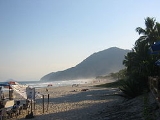
The city is famous for its beaches, which makes it a popular tourism destination, specially for people from the state of São Paulo. Near the boundary with Bertioga there is a small Guarani village managed by FUNAI
.
and confronted the Portuguese, the Tupiniquins united with the Portuguese and the Tupinambás, with the French. This battle between them was witnessed and narrated by Hans Staden
.
The municipality was named after Saint Sebastian because of the day that the Américo Vespúcio expedition sailed through the channel between the city and Ilhabela – January 20, 1502.
The first Portuguese to settle there were Diogo de Unhate, Diogo Dias, João de Abreu, Gonçalo Pedroso and Francisco de Escobar Ortiz, just after the division of Brazil in capitanias hereditárias. São Sebastião was part of the Captaincy of Santo Amaro. The place was first developed as an agriculture and fishing village. The agricultural activities transformed the village in a major sugar cane producer, which later helped the hamlet to earn its village status on March 16, 1636. To gain this status, though, the village had to build a church in honour of Saint Sebastian.
A few years after this, another hamlet developed just north of São Sebastião: São Francisco da Praia (Saint Francis of the Beach). In 1840, the hamlet took the first step to become independent: they asked it to become a freguesia
. The request was eventually accepted in the same year, but the freguesia was disestablished in 1859 and re-joined to São Sebastião.
The city kept on basing its economy on the production of sugar cane, coffea
, tobacco
and fishing. The local port was widely used to load ships with gold
from Minas Gerais
during the 17th and 18th centuries. It was also used by pirates and smugglers.
When slavery
was abolished, in 1888, and the railway linking São Paulo to the bigger Port of Santos
was opened, the city's economy entered a period of crisis, and the population decreased. From that moment on, the city began to rely on subsistence agriculture
and "handicraft fishing" (Pesca Artesanal), a type of fishing done entirely by hand since the fishing until the consumption (in other words, no machinery is used, and most of the people who practice it do it for subsistence as well).
Until the sixties
, nothing much has changed. However, in that decade, Petrobras
built its oil terminal, attracting new employees and investments. The occupation of the city became wider and faster. While the city centre kept its development, workers from other parts of Brazil built their houses near the Serra do Mar, originating the neighborhood of Topolândia, which now concentrates the lower class families.
São Sebastião became a tourist destination in the late eighties
, when the Rodovia Rio-Santos (a section of the BR-101 that connects Santos to Rio de Janeiro
) was completed and paved. Most of the lands were sold to countryside or paulistanas
families who wished a house to spend the weekends and holidays. Most of the Caiçaras (people who make a living out of fishing) started to work with tourism, even though a few of them still earn money from the fish.
Until nowadays, tourism plays an important role in the city's economy. However, as the city grew, proper water and sewage pipes have not been built, which lead to the lack of proper urban infrastructure. Less than 50% of the city's sewage receives proper treatment. Besides, improper housing became a major problem, as more houses are built in Mata Atlântica
zones which, apart from being subject to preservation, are highly likely to suffer from mudslides.
to Boracéia Beach (the last before Bertioga), hotels, weekend houses and nightclubs dominate the plains. The Guaratuba River marks the border with Bertioga, while the Juqueriquerê River marks the border with Caraguatatuba.
The city has an Oceanic climate
, with an annual average temperature of 24 °C. Most of the mountainous terrain and the islands are covered with the Atlantic Forest.
Two districts make up the municipality: São Sebastião District (Distrito de São Sebastião) and Maresias District (Distrito de Maresias).
 There are a number of islands spread all over the city's coastline. The largest and most famous is the Ilha de São Sebastião (São Sebastião Island), which is part of the municipality of Ilhabela.
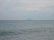
 The Alcatrazes Archipelago is formed by five bigger islands (Alcatrazes Island, Sapata Island, Paredão Island, Porto Island (aka Farol Island) and Southern island), and some smaller unnamed islands. It is the farthest island of São Sebastião, being some 30 km (18.6 mi) away from the southern tip of Ilhabela and 35 km (21.7 mi) from the nearest continent beach, Boiçucanga
. Several birds, whales and other sea animals stop there seasonally to reproduce. The main island was once used by the Brazilian Navy
as a howitzer
shooting exercise point. As the shots were harming the environment of the island (either because of the noise, either because of the impacts), the Brazilian Navy quit exercising. However, the island is still ruled by the military, who forbid fishing, diving and visiting on the island, except for researchers.
 The Ilha Montão de Trigo lies 10 km (6.2 mi) south of the nearest beach (Barra do Una). The highest point of the island is at 276 m AMSL. It is permanently inhabited by a small group of caiçaras.
1,107,595,000.00 and a GDP per capita of R$15,138.
, most of them containing bars, hotels and restaurants. The other part is located near the sea, and concentrates most of the nightlife. There are many bars and ice cream shops, a handicraft fair and a large leisure square.
, called Avenue Dr. Manoel Hipólito do Rego in the central portion of the city and Prestes Maia Highway on the rest of the city. It is possible to come from Caraguatatuba to the north or Bertioga to the south. The highway is the most important road of the city, connecting it from north to south, and having a regular bus line running all through it. Bicycles are also widely used in the city.
Fort Lauderdale, Florida
Brazil
Brazil , officially the Federative Republic of Brazil , is the largest country in South America. It is the world's fifth largest country, both by geographical area and by population with over 192 million people...
ian city, located on the southeast coast of Brazil, in the state of São Paulo
São Paulo (state)
São Paulo is a state in Brazil. It is the major industrial and economic powerhouse of the Brazilian economy. Named after Saint Paul, São Paulo has the largest population, industrial complex, and economic production in the country. It is the richest state in Brazil...
. The population in 2006 is 75,886, its density is 188.1/km² and the area is 403 km². The Tropic of Capricorn
Tropic of Capricorn
The Tropic of Capricorn, or Southern tropic, marks the most southerly latitude on the Earth at which the Sun can be directly overhead. This event occurs at the December solstice, when the southern hemisphere is tilted towards the Sun to its maximum extent.Tropic of Capricorn is one of the five...
lies 25 km north. The municipality existed since 1636 and formed a part of the old hereditary captaincy
Captaincy
A captaincy is a historical administrative division of the former Spanish and Portuguese colonial empires. Each was governed by a captain general.-In the Portuguese Empire:...
of Santo Amaro.
The archipelago municipality of Ilhabela is located on the east coast of the city of São Sebastião; the largest island of the archipelago is also called São Sebastião. Between the city and the island, there is the São Sebastião channel with 30 kilometres in length, and variable width (2 km being the shortest crossing). At the channel there is an oil terminal owned by Transpetro
Transpetro
Petrobras Transporte S.A. is the largest oil and gas transportation company of Brazil. Transpetro works with transportation and storage activities of oil and byproducts, ethanol, biofuels and natural gas...
, a subsidiary of Petrobrás
Petrobras
Petróleo Brasileiro or Petrobras is a semi-public Brazilian multinational energy corporation headquartered in Rio de Janeiro, Brazil. It is the largest company in Latin America by market capitalization and revenue, and the largest company headquartered in the Southern Hemisphere by market...
.
The city is famous for its beaches, which makes it a popular tourism destination, specially for people from the state of São Paulo. Near the boundary with Bertioga there is a small Guarani village managed by FUNAI
Fundação Nacional do Índio
Fundação Nacional do Índio or FUNAI is a Brazilian governmental protection agency for Indian interests and their culture.It was originally called the SPI and was founded by the Brazilian Marshal Cândido Rondon in 1910, who also created the agency's motto, "Die if necessary, but never kill." The...
.
History
Before the Portuguese first arrived, the area was inhabited by the Tupinambás to the north and the Tupiniquins to the south. Both tribes were separated by the Serra de Boiçucanga (Boiçucanga Mountain range), located 30 km south of the city centre. Both tribes disliked each other. When the French arrived in Brazil via the Guanabara BayGuanabara Bay
Guanabara Bay is an oceanic bay located in southeastern Brazil in the state of Rio de Janeiro. On its western shore lies the city of Rio de Janeiro, and on its eastern shore the cities of Niterói and São Gonçalo. Four other municipalities surround the bay's shores...
and confronted the Portuguese, the Tupiniquins united with the Portuguese and the Tupinambás, with the French. This battle between them was witnessed and narrated by Hans Staden
Hans Staden
Hans Staden was a German soldier and mariner who voyaged to South America. On one voyage, he was captured by the Tupinambá people of Brazil whom he claimed practiced cannibalism...
.
The municipality was named after Saint Sebastian because of the day that the Américo Vespúcio expedition sailed through the channel between the city and Ilhabela – January 20, 1502.
The first Portuguese to settle there were Diogo de Unhate, Diogo Dias, João de Abreu, Gonçalo Pedroso and Francisco de Escobar Ortiz, just after the division of Brazil in capitanias hereditárias. São Sebastião was part of the Captaincy of Santo Amaro. The place was first developed as an agriculture and fishing village. The agricultural activities transformed the village in a major sugar cane producer, which later helped the hamlet to earn its village status on March 16, 1636. To gain this status, though, the village had to build a church in honour of Saint Sebastian.
A few years after this, another hamlet developed just north of São Sebastião: São Francisco da Praia (Saint Francis of the Beach). In 1840, the hamlet took the first step to become independent: they asked it to become a freguesia
Freguesia
Freguesia is the Portuguese term for a secondary local administrative unit in Portugal and some of its former colonies, and a former secondary local administrative unit in Macau, roughly equivalent to an administrative parish. A freguesia is a subdivision of a concelho, the Portuguese synonym term...
. The request was eventually accepted in the same year, but the freguesia was disestablished in 1859 and re-joined to São Sebastião.
The city kept on basing its economy on the production of sugar cane, coffea
Coffea
Coffea is a genus of flowering plants in the Rubiaceae family. They are shrubs or small trees native to tropical and southern Africa and tropical Asia. Seeds of several species are the source of the popular beverage coffee. Coffee ranks as one of the world's most valuable and widely traded...
, tobacco
Tobacco
Tobacco is an agricultural product processed from the leaves of plants in the genus Nicotiana. It can be consumed, used as a pesticide and, in the form of nicotine tartrate, used in some medicines...
and fishing. The local port was widely used to load ships with gold
Gold
Gold is a chemical element with the symbol Au and an atomic number of 79. Gold is a dense, soft, shiny, malleable and ductile metal. Pure gold has a bright yellow color and luster traditionally considered attractive, which it maintains without oxidizing in air or water. Chemically, gold is a...
from Minas Gerais
Minas Gerais
Minas Gerais is one of the 26 states of Brazil, of which it is the second most populous, the third richest, and the fourth largest in area. Minas Gerais is the Brazilian state with the largest number of Presidents of Brazil, the current one, Dilma Rousseff, being one of them. The capital is the...
during the 17th and 18th centuries. It was also used by pirates and smugglers.
When slavery
Slavery in Brazil
Slavery in Brazil shaped the country's social structure and ethnic landscape. During the colonial epoch and for over six decades after the 1822 independence, slavery was a mainstay of the Brazilian economy, especially in mining, cotton, and sugar cane production.Brazil obtained an estimated 35% of...
was abolished, in 1888, and the railway linking São Paulo to the bigger Port of Santos
Port of Santos
The Port of Santos is located in the city of Santos, Brazil. As of 2006, it is the busiest container port in Latin America. It possesses a wide variety of cargo handling terminals - solid and liquid bulk, containers and general loads. It is Brazil's leading port in container traffic...
was opened, the city's economy entered a period of crisis, and the population decreased. From that moment on, the city began to rely on subsistence agriculture
Subsistence agriculture
Subsistence agriculture is self-sufficiency farming in which the farmers focus on growing enough food to feed their families. The typical subsistence farm has a range of crops and animals needed by the family to eat and clothe themselves during the year. Planting decisions are made with an eye...
and "handicraft fishing" (Pesca Artesanal), a type of fishing done entirely by hand since the fishing until the consumption (in other words, no machinery is used, and most of the people who practice it do it for subsistence as well).
Until the sixties
1960s
The 1960s was the decade that started on January 1, 1960, and ended on December 31, 1969. It was the seventh decade of the 20th century.The 1960s term also refers to an era more often called The Sixties, denoting the complex of inter-related cultural and political trends across the globe...
, nothing much has changed. However, in that decade, Petrobras
Petrobras
Petróleo Brasileiro or Petrobras is a semi-public Brazilian multinational energy corporation headquartered in Rio de Janeiro, Brazil. It is the largest company in Latin America by market capitalization and revenue, and the largest company headquartered in the Southern Hemisphere by market...
built its oil terminal, attracting new employees and investments. The occupation of the city became wider and faster. While the city centre kept its development, workers from other parts of Brazil built their houses near the Serra do Mar, originating the neighborhood of Topolândia, which now concentrates the lower class families.
São Sebastião became a tourist destination in the late eighties
1980s
File:1980s decade montage.png|thumb|400px|From left, clockwise: The first Space Shuttle, Columbia, lifted off in 1981; American President Ronald Reagan and Soviet leader Mikhail Gorbachev eased tensions between the two superpowers, leading to the end of the Cold War; The Fall of the Berlin Wall in...
, when the Rodovia Rio-Santos (a section of the BR-101 that connects Santos to Rio de Janeiro
Rio de Janeiro
Rio de Janeiro , commonly referred to simply as Rio, is the capital city of the State of Rio de Janeiro, the second largest city of Brazil, and the third largest metropolitan area and agglomeration in South America, boasting approximately 6.3 million people within the city proper, making it the 6th...
) was completed and paved. Most of the lands were sold to countryside or paulistanas
São Paulo
São Paulo is the largest city in Brazil, the largest city in the southern hemisphere and South America, and the world's seventh largest city by population. The metropolis is anchor to the São Paulo metropolitan area, ranked as the second-most populous metropolitan area in the Americas and among...
families who wished a house to spend the weekends and holidays. Most of the Caiçaras (people who make a living out of fishing) started to work with tourism, even though a few of them still earn money from the fish.
Until nowadays, tourism plays an important role in the city's economy. However, as the city grew, proper water and sewage pipes have not been built, which lead to the lack of proper urban infrastructure. Less than 50% of the city's sewage receives proper treatment. Besides, improper housing became a major problem, as more houses are built in Mata Atlântica
Mata Atlântica
The Atlantic Forest is a region of tropical and subtropical moist forest, tropical dry forest, tropical savanna, semi deciduous forest and mangrove forests which extends along the Atlantic coast of Brazil from Rio Grande do Norte state in the north to Rio Grande do Sul state in the south, and...
zones which, apart from being subject to preservation, are highly likely to suffer from mudslides.
Geography
Virtually everything of the city is located at the narrow plains between the Atlantic Ocean and the mountains, except for some cell phone towers and electricity pylons. In the central portion of the city, these plains are never wider than 3 km, although they may measure up to 6 km in the less developed areas to the west. Most of the city concentrates between the Enseada Beach (the last before Caraguatatuba) and the Guaecá Beach. From Toque Toque Grande beachToque Toque Grande and Toque Toque Pequeno
Toque-Toque Grande and Toque-Toque Pequeno are two beaches at the Atlantic Ocean in the city of São Sebastião, SP, Brasil. They are separated by another beach called "das Calhetas", being 2,4km away from each other.- Toque-Toque Grande :...
to Boracéia Beach (the last before Bertioga), hotels, weekend houses and nightclubs dominate the plains. The Guaratuba River marks the border with Bertioga, while the Juqueriquerê River marks the border with Caraguatatuba.
The city has an Oceanic climate
Oceanic climate
An oceanic climate, also called marine west coast climate, maritime climate, Cascadian climate and British climate for Köppen climate classification Cfb and subtropical highland for Köppen Cfb or Cwb, is a type of climate typically found along the west coasts at the middle latitudes of some of the...
, with an annual average temperature of 24 °C. Most of the mountainous terrain and the islands are covered with the Atlantic Forest.
Two districts make up the municipality: São Sebastião District (Distrito de São Sebastião) and Maresias District (Distrito de Maresias).
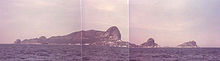
Islands
Toque-Toque Islands
From north to south, the Toque-Toque Grande island is the first after Ilhabela, and is located in front of the beach of same name. There are neither beaches nor people there, but the place is visited for scubadiving. The nearby Toque-Toque Pequeno Island is smaller, and resembles a turtle when seen from the Santiago Beach.Alcatrazes Islands
Boiçucanga
Boiçucanga is a beach and neighborhood in the city of São Sebastião, located on São Paulo state's northern coastline. The name comes from the Tupiniquim Indian language. Boi means snake. Açu means big and Canga means head. The sea at the beach is calm and has thick, yellowish sand....
. Several birds, whales and other sea animals stop there seasonally to reproduce. The main island was once used by the Brazilian Navy
Brazilian Navy
The Brazilian Navy is a branch of the Brazilian Armed Forces responsible for conducting naval operations. It is the largest navy in Latin America...
as a howitzer
Howitzer
A howitzer is a type of artillery piece characterized by a relatively short barrel and the use of comparatively small propellant charges to propel projectiles at relatively high trajectories, with a steep angle of descent...
shooting exercise point. As the shots were harming the environment of the island (either because of the noise, either because of the impacts), the Brazilian Navy quit exercising. However, the island is still ruled by the military, who forbid fishing, diving and visiting on the island, except for researchers.
Gatos Island
The Ilha dos Gatos (Cats Island, located 1.8 km (1.1 mi) from the Ponta da Baleia (Whale Edge), a hill between the Camburi Beach and da Baleia Beach) and Ilha das Couves (Cabbages Island, located 2.4 km (1.5 mi) from the coast and mere 600 m (1,920 ft) south of As Ilhas) are both deserted, but eventually visited by tourists.As Ilhas
As Ilhas (The Islands) differ from the other islands because there's a beach there, which is frequently visited by tourists from the nearby Barra do Saí and Juqueí beaches, both located around 2.4 km (1.5 mi) from the island.Montão de Trigo Island
Economy
As of 2005, the city has a GDP of R$Brazilian real
The real is the present-day currency of Brazil. Its sign is R$ and its ISO code is BRL. It is subdivided into 100 centavos ....
1,107,595,000.00 and a GDP per capita of R$15,138.
Sites of interest
Apart from its 36 beaches (see below), the city has a few places to visit, like the Igreja Matriz de São Sebastião, the Museu de Arte Sacra (Sacred Art Museum), the Convento da Nossa Senhora do Amparo and the Convento Franciscano. The city centre can be divided in two parts. One of them is located around the Igreja Matriz, and is filled with houses from the colonial periodColonial Brazil
In the history of Brazil, Colonial Brazil, officially the Viceroyalty of Brazil comprises the period from 1500, with the arrival of the Portuguese, until 1815, when Brazil was elevated to kingdom alongside Portugal as the United Kingdom of Portugal, Brazil and the Algarves.During the over 300 years...
, most of them containing bars, hotels and restaurants. The other part is located near the sea, and concentrates most of the nightlife. There are many bars and ice cream shops, a handicraft fair and a large leisure square.
Beaches
There are 36 beaches throughout the more than 100 km (161 mi) of coast of the city. From North to South:
|
Toque Toque Grande and Toque Toque Pequeno Toque-Toque Grande and Toque-Toque Pequeno are two beaches at the Atlantic Ocean in the city of São Sebastião, SP, Brasil. They are separated by another beach called "das Calhetas", being 2,4km away from each other.- Toque-Toque Grande :... Maresias Maresias is a beach and district at the Atlantic Ocean in the city of São Sebastião, located on São Paulo state's northern coastline, Brazil. The name comes from the ocean breeze that affects the beach and the neighborhood.... Boiçucanga Boiçucanga is a beach and neighborhood in the city of São Sebastião, located on São Paulo state's northern coastline. The name comes from the Tupiniquim Indian language. Boi means snake. Açu means big and Canga means head. The sea at the beach is calm and has thick, yellowish sand.... Juquehy Juqueí is a beach in the city of São Sebastião, São Paulo, located in the northern coastline of São Paulo state. It is famous for its white sands, green mountains and transparent water. Besides its natural attractions, Juquehy is also known for its traditional cuisine, such as "Pescado a Cambucu."... (or Juqueí) |
Transportation
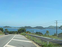
The only way to access the city is via the BR-101BR-101
The BR-101 is a longitudinal highway of Brazil. It is the longest in the country with a length of nearly , and it is also considered the most important....
, called Avenue Dr. Manoel Hipólito do Rego in the central portion of the city and Prestes Maia Highway on the rest of the city. It is possible to come from Caraguatatuba to the north or Bertioga to the south. The highway is the most important road of the city, connecting it from north to south, and having a regular bus line running all through it. Bicycles are also widely used in the city.
Sister city
São Sebastião has one sister city designed by Sister Cities International:Fort Lauderdale, Florida
Fort Lauderdale, Florida
Fort Lauderdale is a city in the U.S. state of Florida, on the Atlantic coast. It is the county seat of Broward County. As of the 2010 census, the city had a population of 165,521. It is a principal city of the South Florida metropolitan area, which was home to 5,564,635 people at the 2010...