

Guanabara Bay
Encyclopedia
Bay
A bay is an area of water mostly surrounded by land. Bays generally have calmer waters than the surrounding sea, due to the surrounding land blocking some waves and often reducing winds. Bays also exist as an inlet in a lake or pond. A large bay may be called a gulf, a sea, a sound, or a bight...
located in southeastern Brazil
Brazil
Brazil , officially the Federative Republic of Brazil , is the largest country in South America. It is the world's fifth largest country, both by geographical area and by population with over 192 million people...
in the state of Rio de Janeiro
Rio de Janeiro (state)
Rio de Janeiro is one of the 27 states of Brazil.Rio de Janeiro has the second largest economy of Brazil behind only São Paulo state.The state of Rio de Janeiro is located within the Brazilian geopolitical region classified as the Southeast...
. On its western shore
Shore
A shore or shoreline is the fringe of land at the edge of a large body of water, such as an ocean, sea, or lake. In Physical Oceanography a shore is the wider fringe that is geologically modified by the action of the body of water past and present, while the beach is at the edge of the shore,...
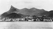
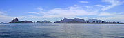
lies the city of Rio de Janeiro, and on its eastern shore the cities of Niterói
Niterói
Niterói is a municipality in the state of Rio de Janeiro, southeast region of Brazil. It has an estimated population of 487,327 inhabitants and an area of ², being the sixth most populous city in the state and the highest Human Development Index. Integrates the Metropolitan Region of Rio de...
and São Gonçalo
São Gonçalo
-Brazil:*São Gonçalo, Rio de Janeiro*São Gonçalo do Amarante, Rio Grande do Norte*São Gonçalo do Amarante, Ceará*São Gonçalo do Abaeté, Minas Gerais*São Gonçalo dos Campos, Bahia*São Gonçalo do Gurguéia, Piauí*São Gonçalo do Pará, Minas Gerais...
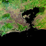
. Four other municipalities surround the bay's shores. Guanabara Bay is the second largest bay in area in Brazil (after the All Saints' Bay), at 412 square kilometres (159.1 sq mi), with a perimeter of 143 kilometres (88.9 mi).
Guanabara Bay is 31 kilometres (19.3 mi) long and 28 kilometres (17.4 mi) wide at its maximum. Its 1.5 kilometre (0.93205910497471 mi) wide mouth is flanked at the eastern tip by the Pico do Papagaio (Parrot's Peak) and the western tip by Pão de Açúcar (Sugar Loaf).
Name origin
The name Guanabara comes from the Tupi language, goanã-pará, from gwa "bay", plus nã "similar to" and ba'ra "sea". Traditionally, it is also translated as "the bosom of sea."History
Gaspar de Lemos
Gaspar de Lemos , Portuguese explorer and captain of the supply ship of Pedro Álvares Cabral's fleet that discovered Brazil. Sent back to Portugal with news of their discovery, he was credited by the Viscount of Santarém as having discovered the Fernando de Noronha archipelago in the Atlantic Ocean....
and Gonçalo Coelho
Gonçalo Coelho
Gonçalo Coelho was a Portuguese explorer who belonged to a prominent family in northern Portugal. He commanded two expeditions which explored much of the coast of Brazil....
arrived on its shores. According to some historians, the name given by the exploration team to the bay was originally Ria de Janeiro "January Sound", then a confusion took place between the word ria, which at the time was used to designate a bay
Bay
A bay is an area of water mostly surrounded by land. Bays generally have calmer waters than the surrounding sea, due to the surrounding land blocking some waves and often reducing winds. Bays also exist as an inlet in a lake or pond. A large bay may be called a gulf, a sea, a sound, or a bight...
or a sound
Sound (geography)
In geography a sound or seaway is a large sea or ocean inlet larger than a bay, deeper than a bight and wider than a fjord; or it may be defined as a narrow sea or ocean channel between two bodies of land ....
, and rio "river". Anyway, the name of the bay was soon fixed as Rio de Janeiro "January River".
Later, the city was named after the bay. Natives
Indigenous peoples in Brazil
The Indigenous peoples in Brazil comprise a large number of distinct ethnic groups who inhabited the country prior to the European invasion around 1500...
of the Tamoio and Tupiniquim
Tupiniquim
Tupiniquim is the name of an Amerindian tribe who now only live in three reservations . All three are located in the municipality of Aracruz in northern Espírito Santo state, southeastern Brazil. As of 1997 their population was 1,386...
tribes inhabited the shores of the bay.
After the initial arrival of the Portuguese, no significant European settlements were established until French colonist and soldiers, under the Huguenot
Huguenot
The Huguenots were members of the Protestant Reformed Church of France during the 16th and 17th centuries. Since the 17th century, people who formerly would have been called Huguenots have instead simply been called French Protestants, a title suggested by their German co-religionists, the...
Admiral Nicolas Durand de Villegaignon
Nicolas Durand de Villegaignon
Nicolas Durand, sieur de Villegaignon, also Villegagnon was a Commander of the Knights of Malta, and later a French naval officer who attempted to help the Huguenots in France escape persecution.A notable public figure in his time, Villegaignon was a mixture of soldier,...
invaded the region in 1555 to establish the France Antarctique
France Antarctique
France Antarctique was a French colony south of the Equator, in Rio de Janeiro, Brazil, which existed between 1555 and 1567, and had control over the coast from Rio de Janeiro to Cabo Frio...
. They stayed briefly on Lajes Island, then moved to Serigipe Island, near the shore, where they built Fort Coligny
Fort Coligny
Fort Coligny was a fortress founded by Nicolas Durand de Villegaignon in Rio de Janeiro, Brazil in 1555, in what constituted the so-called France Antarctique historical episode....
. After they were expelled by Portuguese military expeditions in 1563, the colonial government built fortifications in several points of Guanabara Bay, rendering it almost impregnable against a naval attack from the sea. They were the Santa Cruz, São João, Lajes and Villegaignon forts, forming a fearsome crossfire rectangle of big naval guns
Artillery
Originally applied to any group of infantry primarily armed with projectile weapons, artillery has over time become limited in meaning to refer only to those engines of war that operate by projection of munitions far beyond the range of effect of personal weapons...
. Other islands were adapted by the Navy
Navy
A navy is the branch of a nation's armed forces principally designated for naval and amphibious warfare; namely, lake- or ocean-borne combat operations and related functions...
to host naval storehouses, hospitals, drydocks, oil reservoir
Oil reservoir
A petroleum reservoir, or oil and gas reservoir, is a subsurface pool of hydrocarbons contained in porous or fractured rock formations. The naturally occurring hydrocarbons, such as crude oil or natural gas, are trapped by overlying rock formations with lower permeability...
s and the National Naval Academy.
Description
- Lajes
- GovernadorGovernador IslandGovernador Island is the largest island in Guanabara Bay, in Rio de Janeiro, Brazil. It has a population of about 500,000 inhabitants, in a small area of ....
– site of Rio de Janeiro's Galeão - Antônio Carlos Jobim International AirportGaleão - Antônio Carlos Jobim International AirportRio de Janeiro/Galeão-Antonio Carlos Jobim International Airport popularly known by its original name Galeão International Airport is the main airport serving Rio de Janeiro, Brazil... - Galeão
- PaquetáPaquetá IslandPaquetá Island is an island in Guanabara Bay, Rio de Janeiro. The name of the island is a Tupi word meaning "many pacas". The island is an auto-free zone, so travel is limited to bicycles and horse-drawn carriages. Paquetá has twenty baobabs, a type of African tree - the only ones in Brazil beside...
- Cobras
- Flores
- Fiscal
- Ilha da Boa Viagem
- Villegaignon
- Fundão
The bay is crossed by the mighty Rio-Niterói Bridge
Rio-Niterói Bridge
President Costa e Silva Bridge, commonly known as the Rio-Niteroi Bridge, is a box girder bridge located at Guanabara Bay, in the State of Rio de Janeiro in Brazil. It connects the cities of Rio de Janeiro and the municipality of Niterói. It is currently the longest prestressed concrete bridge in...
(13.29 kilometres (8.3 mi) long and with a central span 72 metres (236.2 ft) high) and there is heavy boat and ship traffic, including regular ferryboat lines. The Port of Rio de Janeiro, as well as the city's two airports, Galeão - Antônio Carlos Jobim International Airport
Galeão - Antônio Carlos Jobim International Airport
Rio de Janeiro/Galeão-Antonio Carlos Jobim International Airport popularly known by its original name Galeão International Airport is the main airport serving Rio de Janeiro, Brazil...
(on Governador Island) and Santos Dumont Airport (on a landfill
Landfill
A landfill site , is a site for the disposal of waste materials by burial and is the oldest form of waste treatment...
next to downtown Rio), are located on its shores. The Federal University of Rio de Janeiro main campus is located on the artificial Fundão Island. A maze of smaller bridges seamlessly interconnect the two largest islands, Fundão and Governador, to the mainland.
Serra do Mar
Serra do Mar is a 1,500 km long system of mountain ranges and escarpments in Southeastern Brazil, which runs in parallel to the Atlantic Ocean coast from the state of Espírito Santo to southern Santa Catarina, although some include Serra Geral in the Serra do Mar, in which case this range...
. It borders Rio de Janeiro, widely considered one of the most beautiful cities in the world, making it one of the world's premier tourist
Tourism
Tourism is travel for recreational, leisure or business purposes. The World Tourism Organization defines tourists as people "traveling to and staying in places outside their usual environment for not more than one consecutive year for leisure, business and other purposes".Tourism has become a...
destinations.
Environment
Guanabara Bay's once rich and diversified ecosystemEcosystem
An ecosystem is a biological environment consisting of all the organisms living in a particular area, as well as all the nonliving , physical components of the environment with which the organisms interact, such as air, soil, water and sunlight....
has suffered extensive damage in recent decades, particularly along its mangrove
Mangrove
Mangroves are various kinds of trees up to medium height and shrubs that grow in saline coastal sediment habitats in the tropics and subtropics – mainly between latitudes N and S...
areas. The bay has been heavily impacted by urbanization
Urbanization
Urbanization, urbanisation or urban drift is the physical growth of urban areas as a result of global change. The United Nations projected that half of the world's population would live in urban areas at the end of 2008....
, deforestation
Deforestation
Deforestation is the removal of a forest or stand of trees where the land is thereafter converted to a nonforest use. Examples of deforestation include conversion of forestland to farms, ranches, or urban use....
, and pollution
Water pollution
Water pollution is the contamination of water bodies . Water pollution occurs when pollutants are discharged directly or indirectly into water bodies without adequate treatment to remove harmful compounds....
of its waters with sewage
Sewage
Sewage is water-carried waste, in solution or suspension, that is intended to be removed from a community. Also known as wastewater, it is more than 99% water and is characterized by volume or rate of flow, physical condition, chemical constituents and the bacteriological organisms that it contains...
, garbage
Waste
Waste is unwanted or useless materials. In biology, waste is any of the many unwanted substances or toxins that are expelled from living organisms, metabolic waste; such as urea, sweat or feces. Litter is waste which has been disposed of improperly...
, and oil spills.
In 2000, a leaking underwater pipeline released 1300000 litre of oil into Guanabara Bay, destroying large swaths of the mangrove ecosystem
Ecosystem
An ecosystem is a biological environment consisting of all the organisms living in a particular area, as well as all the nonliving , physical components of the environment with which the organisms interact, such as air, soil, water and sunlight....
. Recovery measures are currently being attempted, but more than a decade after the incident, the mangrove areas have not returned to life. According to reporter Gabriel Elizondo, who visited the scene of the oil spill in 2010, "The mud is thick, black and lifeless. And it omg stinks. Dead stumps – what used to be thick green mangrove swamps – protrude out from the mud as far as your eyes see....Nothing is growing here, and I can’t imagine anything growing here in a very long time. It's sad."
External links
- Information Center for Guanabara Bay. State Government of Rio de Janeiro (in Portuguese).