
Surrey Hills, Victoria
Encyclopedia
Surrey Hills is a suburb in Melbourne
, Victoria
, Australia
, 12 km east from Melbourne's central business district
. Its Local Government Area lies within the cities of Boroondara
and Whitehorse
. At the 2006 Census, Surrey Hills had a population of 13,105.
purchase in 1841.
The Surrey Hills area was first developed by a Real Estate consortia following the extension of the railway line from Camberwell
to Lilydale
in 1882, Surrey Hills Post Office opened on 1 October 1884.
Housing estates were laid out and lovely period homes built in either brick or weatherboard with most designs being influenced by the Victorian, Federation and Edwardian era. The streets were planted mainly with avenues of Pin Oak and Plane trees which are now mature and offer a pleasant shady vista. The streets have impressive names such as Empress, Kingston, Surrey, Balmoral, Leopold, Windsor, Albert and Wolseley, but the area was considered too distant from the nearest shopping districts; Camberwell
to the West and Box Hill
to the East. The economic depression of the 1890s brought development to a halt and the next major phase of suburban development didn't take place until after the First World War.
During the 1990s, the last bank branch in the Union Road shopping strip closed, which caused some concern within both the local community and local traders. On 24 February 2003, the Surrey Hills Community Bank (a community bank branch of Bendigo Bank
) opened for business in Union Road.
, who served a distinguished career and became a hero in the British army in the late 1800s & early 1900.
It has 2 local primary schools: Surrey Hills Primary & Chatham Primary School. Surrey Hills' central business district is relatively small consisting of a 300 metre strip of shops along Union Road which features Surrey Hills railway station (on the Belgrave and Lilydale railway line). Heading out from Melbourne's CBD, Union road is the first railway level crossing on the Belgrave/Lilydale train line.
Surrey Hills also has Chatham railway station
south of Canterbury Road, between Stanley Terrace and Junction Road. Chatham station can be accessed from the north by laneways between houses, beginning near Mont Albert Road General Store, then continuing south along the Canterbury Sports Ground pathway. Most working residents of Surrey Hills commute to Melbourne either by car or train. To reach a safe bicycle path for the city commute, cyclists must travel south to the Gardiners Creek Trail
or north to the Yarra River Trail, via the Outer Circle Trail
. A bike lane is on Mont Albert Road.
To the north, Surrey Hills is also serviced by the route 109 tram
which continues from Port Melbourne
, along Collins St. (Melb.CBD), along Whitehorse Rd. to Box Hill
and in the south, the route 70 tram
travels along Riversdale Road from the city to the Wattle Park terminus at the Elgar Road junction.
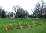
 The major parks and gardens in Surrey Hills are Surrey Gardens
and South Surrey Park
. Surrey Hills is also adjacent to Wattle Park
which is just across Riversdale Road
to the South in Burwood
.
club, Canterbury 'Cobras', who currently compete in the Eastern Football League
., Canterbury Cricket Club which plays on a turf wicket and Canterbury Tennis Club which has its own Club house and 4 en-tou-cas courts.
Melbourne
Melbourne is the capital and most populous city in the state of Victoria, and the second most populous city in Australia. The Melbourne City Centre is the hub of the greater metropolitan area and the Census statistical division—of which "Melbourne" is the common name. As of June 2009, the greater...
, Victoria
Victoria (Australia)
Victoria is the second most populous state in Australia. Geographically the smallest mainland state, Victoria is bordered by New South Wales, South Australia, and Tasmania on Boundary Islet to the north, west and south respectively....
, Australia
Australia
Australia , officially the Commonwealth of Australia, is a country in the Southern Hemisphere comprising the mainland of the Australian continent, the island of Tasmania, and numerous smaller islands in the Indian and Pacific Oceans. It is the world's sixth-largest country by total area...
, 12 km east from Melbourne's central business district
Melbourne city centre
Melbourne City Centre is an area of Melbourne in Victoria, Australia. It is not to be confused with the larger local government area of the City of Melbourne...
. Its Local Government Area lies within the cities of Boroondara
City of Boroondara
The City of Boroondara is a Local Government Area in Victoria, Australia. It is located in the eastern suburbs of Melbourne.This area was originally occupied by the Wurundjeri, Indigenous Australians of the Kulin nation....
and Whitehorse
City of Whitehorse
The City of Whitehorse is a Local Government Area in Victoria, Australia. It is located in the eastern suburbs of Melbourne. It has an area of and has a estimated population of 155,725 people....
. At the 2006 Census, Surrey Hills had a population of 13,105.
History
The Surrey Hills area was acquired from the Crown by Henry Elgar as part of his Special SurveyElgar's Special Survey
In 1841, Henry Elgar purchased or eight square miles of land approximately 10 km east of Melbourne, Victoria, Australia. The land was purchased from the Crown for one pound an acre under the terms of the short-lived Special Survey regulations....
purchase in 1841.
The Surrey Hills area was first developed by a Real Estate consortia following the extension of the railway line from Camberwell
Camberwell, Victoria
Camberwell is a suburb in Melbourne, Victoria, Australia, 9 km east from Melbourne's central business district. Its Local Government Area is the City of Boroondara. At the 2006 Census, Camberwell had a population of 19,637....
to Lilydale
Lilydale, Victoria
Lilydale is a suburb of Melbourne, Victoria, Australia, 35 km north-east from Melbourne's central business district situated in the Olinda Creek valley. At the 2006 Census, Lilydale had a population of 13,887...
in 1882, Surrey Hills Post Office opened on 1 October 1884.
Housing estates were laid out and lovely period homes built in either brick or weatherboard with most designs being influenced by the Victorian, Federation and Edwardian era. The streets were planted mainly with avenues of Pin Oak and Plane trees which are now mature and offer a pleasant shady vista. The streets have impressive names such as Empress, Kingston, Surrey, Balmoral, Leopold, Windsor, Albert and Wolseley, but the area was considered too distant from the nearest shopping districts; Camberwell
Camberwell, Victoria
Camberwell is a suburb in Melbourne, Victoria, Australia, 9 km east from Melbourne's central business district. Its Local Government Area is the City of Boroondara. At the 2006 Census, Camberwell had a population of 19,637....
to the West and Box Hill
Box Hill, Victoria
Box Hill is a suburb in Melbourne, Victoria, Australia, 14 km east from Melbourne's central business district. Its Local Government Area is the City of Whitehorse. At the 2006 Census, Box Hill had a population of 8,616....
to the East. The economic depression of the 1890s brought development to a halt and the next major phase of suburban development didn't take place until after the First World War.
During the 1990s, the last bank branch in the Union Road shopping strip closed, which caused some concern within both the local community and local traders. On 24 February 2003, the Surrey Hills Community Bank (a community bank branch of Bendigo Bank
Bendigo Bank
Bendigo Bank is an Australian financial institution, operating primarily in retail banking. The company merged with Adelaide Bank in November 2007, with shareholders voting in March 2008 to change the merged company’s name to Bendigo and Adelaide Bank Limited.Before the merger, Bendigo Bank...
) opened for business in Union Road.
Today
Surrey Hills contains both the 'English Counties District', which is a small area between Canterbury and Riversdale Roads where the streets are named after English Counties, including Norfolk, Durham, Kent, Middlesex, Essex, Suffolk Roads, and the 'Chatham Precinct' which is situated between Canterbury, Union, Mont Albert & Chatham Rds. The latter streets are named after English places (Croydon, Guildford & Surrey) and Sir Garnet Road, named in honour of a famous British Army General (Garnet Wolseley, 1st Viscount WolseleyGarnet Wolseley, 1st Viscount Wolseley
Field Marshal Garnet Joseph Wolseley, 1st Viscount Wolseley, KP, GCB, OM, GCMG, VD, PC was an Anglo-Irish officer in the British Army. He served in Burma, the Crimean War, the Indian Mutiny, China, Canada, and widely throughout Africa—including his Ashanti campaign and the Nile Expedition...
, who served a distinguished career and became a hero in the British army in the late 1800s & early 1900.
It has 2 local primary schools: Surrey Hills Primary & Chatham Primary School. Surrey Hills' central business district is relatively small consisting of a 300 metre strip of shops along Union Road which features Surrey Hills railway station (on the Belgrave and Lilydale railway line). Heading out from Melbourne's CBD, Union road is the first railway level crossing on the Belgrave/Lilydale train line.
Surrey Hills also has Chatham railway station
Chatham railway station, Melbourne
Chatham is a railway station in Melbourne, Victoria, Australia, located in the suburb of Surrey Hills, on the Lilydale and Belgrave railway lines...
south of Canterbury Road, between Stanley Terrace and Junction Road. Chatham station can be accessed from the north by laneways between houses, beginning near Mont Albert Road General Store, then continuing south along the Canterbury Sports Ground pathway. Most working residents of Surrey Hills commute to Melbourne either by car or train. To reach a safe bicycle path for the city commute, cyclists must travel south to the Gardiners Creek Trail
Gardiners Creek Trail
The Gardiners Creek Trail is a shared use path for cyclists and pedestrians, which follows Gardiners Creek through the eastern suburbs of Melbourne, Victoria, Australia....
or north to the Yarra River Trail, via the Outer Circle Trail
Outer Circle Trail
The Outer Circle Trail, also known as the Anniversary Trail, Anniversary Outer Circle Trail, or even the Outer Circle Anniversary Trail, is a shared use path for cyclists and pedestrians, which partly follows the Alamein Line through the inner eastern suburbs of Melbourne, Victoria, Australia.The...
. A bike lane is on Mont Albert Road.
To the north, Surrey Hills is also serviced by the route 109 tram
Melbourne tram route 109
Tram route 109 or simply The 109 is a public transport service in Melbourne, Victoria, Australia. It runs between a terminus in Box Hill and a terminus near Station Pier in Port Melbourne...
which continues from Port Melbourne
Port Melbourne, Victoria
Port Melbourne is a suburb of Melbourne, Victoria, Australia, 5 km southwest of Melbourne's central business district. Its Local Government areas are the cities of Port Phillip and Melbourne. At the 2006 Census, Port Melbourne had a population of 13,293....
, along Collins St. (Melb.CBD), along Whitehorse Rd. to Box Hill
Box Hill, Victoria
Box Hill is a suburb in Melbourne, Victoria, Australia, 14 km east from Melbourne's central business district. Its Local Government Area is the City of Whitehorse. At the 2006 Census, Box Hill had a population of 8,616....
and in the south, the route 70 tram
Melbourne tram route 70
Tram route 70 is a public transport service in Melbourne, Victoria, Australia. It is operated by Camberwell Depot and runs from the Waterfront City Docklands to Wattle Park in Box Hill South...
travels along Riversdale Road from the city to the Wattle Park terminus at the Elgar Road junction.
Parks and gardens
Surrey Gardens, Melbourne
Surrey Gardens is a park in Melbourne, Australia, located in the suburb of Surrey Hills. The park is situated high in Surrey Hills on sloping land from Union Road in the east to Norfolk Road in the west and contains many mature trees...
and South Surrey Park
South Surrey Park, Melbourne
South Surrey Park is a park in Melbourne, Australia, located in the suburb of Surrey Hills. The park is progressively being replanted with indigenous native species. It is currently maintained by the City of Boroondara and the Friends of South Surrey Park....
. Surrey Hills is also adjacent to Wattle Park
Wattle Park, Melbourne
Wattle Park is a public park in Melbourne, Australia, located in the suburb of Burwood. It is known for its plantation of 12,000 wattle trees. It is currently maintained by Parks Victoria....
which is just across Riversdale Road
Riversdale Road, Melbourne
Riversdale Road is a major east-west thoroughfare in Melbourne, Australia. It runs from Hawthorn to Box Hill South, and includes the many small shopping areas along it, located in Richmond, Hawthorn, Hawthorn East, Camberwell and Surrey Hills. Beyond Hawthorn, the road was originally called...
to the South in Burwood
Burwood, Victoria
Burwood is a suburb in Melbourne, Victoria, Australia, 17 km east from Melbourne's central business district. Its Local Government Area is largely the City of Whitehorse but includes the City of Monash in its south west corner. At the 2006 Census, Burwood had a population of 11,886.-History:The...
.
Sport
Canterbury Sports Ground is located in the North-West of the suburb, and boasts 3 sporting clubs. It has Clubrooms with a canteen and is the home ground of the Australian Rules FootballAustralian rules football
Australian rules football, officially known as Australian football, also called football, Aussie rules or footy is a sport played between two teams of 22 players on either...
club, Canterbury 'Cobras', who currently compete in the Eastern Football League
Eastern Football League (Australia)
The Eastern Football League is an Australian rules football League, based in the eastern suburbs of metropolitan Melbourne....
., Canterbury Cricket Club which plays on a turf wicket and Canterbury Tennis Club which has its own Club house and 4 en-tou-cas courts.
See also
- City of Box HillCity of Box HillThe City of Box Hill was a Local Government Area located about east of Melbourne, the state capital of Victoria, Australia. The city covered an area of , and existed from 1927 until 1994.-History:...
- the former local government area of which part of Surrey Hills was a part.
- City of CamberwellCity of CamberwellThe City of Camberwell was a Local Government Area located about east of Melbourne, the state capital of Victoria, Australia. The city covered an area of , and existed from 1914 until 1994.-History:...
- the former local government area of which part of Surrey Hills was a part.