
Summerhill, New York
Encyclopedia
Summerhill is a town
in Cayuga County
, New York
, United States
. The population was 1,217 at the 2010 census. The current town name is that of a location in Ireland
.
The Town of Summerhill is in the southeast corner of the county and is northeast of Ithaca
, New York
.
, this area was part of the territory of the Onondaga (tribe)
. Afterwards, Summerhill was part of the Central New York Military Tract
, land reserved for veterans. The first settler arrived around 1797.
The town was founded in 1831 from the Town of Locke
originally as the "Town of Plato," but the name was changed to Summerhill in 1832 to avoid conflict with the name of another location.
Much of the town was re-forested by the Civilian Conservation Corps
in the 1930s.
, the town has a total area of 26 square miles (67.3 km²), of which, 25.9 square miles (67.1 km²) of it is land and 0.1 square mile (0.258998811 km²) of it (0.42%) is water.
The south town line is the border of Tompkins County
and the east town line is the border of Cortland County
.
New York State Route 90
is an east-west highway in south of Summerhill. New York State Route 41A
crosses the northeast part of the town.
is to the north and the Town of Locke
is to the west. The Town of Groton
in Tompkins County is on the south and the Town of Homer
in Cortland County is on the east.
of 2000, there were 1,098 people, 393 households, and 304 families residing in the town. The population density
was 42.4 people per square mile (16.4/km²). There were 463 housing units at an average density of 17.9 per square mile (6.9/km²). The racial makeup of the town was 99.27% White, 0.18% African American, 0.18% Native American, and 0.36% from two or more races. Hispanic or Latino of any race were 0.64% of the population.
There were 393 households out of which 37.4% had children under the age of 18 living with them, 60.3% were married couples
living together, 7.9% had a female householder with no husband present, and 22.6% were non-families. 16.0% of all households were made up of individuals and 6.1% had someone living alone who was 65 years of age or older. The average household size was 2.79 and the average family size was 3.06.
In the town the population was spread out with 29.2% under the age of 18, 7.6% from 18 to 24, 30.1% from 25 to 44, 23.8% from 45 to 64, and 9.3% who were 65 years of age or older. The median age was 36 years. For every 100 females there were 105.2 males. For every 100 females age 18 and over, there were 105.0 males.
The median income for a household in the town was $39,000, and the median income for a family was $39,500. Males had a median income of $26,336 versus $24,375 for females. The per capita income
for the town was $14,609. About 6.9% of families and 12.1% of the population were below the poverty line, including 21.8% of those under age 18 and 2.0% of those age 65 or over.
Town
A town is a human settlement larger than a village but smaller than a city. The size a settlement must be in order to be called a "town" varies considerably in different parts of the world, so that, for example, many American "small towns" seem to British people to be no more than villages, while...
in Cayuga County
Cayuga County, New York
Cayuga County is a county located in the U.S. state of New York. It was named for one of the tribes of Indians in the Iroquois Confederation. Its county seat is Auburn.- History :...
, New York
New York
New York is a state in the Northeastern region of the United States. It is the nation's third most populous state. New York is bordered by New Jersey and Pennsylvania to the south, and by Connecticut, Massachusetts and Vermont to the east...
, United States
United States
The United States of America is a federal constitutional republic comprising fifty states and a federal district...
. The population was 1,217 at the 2010 census. The current town name is that of a location in Ireland
Ireland
Ireland is an island to the northwest of continental Europe. It is the third-largest island in Europe and the twentieth-largest island on Earth...
.
The Town of Summerhill is in the southeast corner of the county and is northeast of Ithaca
Ithaca, New York
The city of Ithaca, is a city in upstate New York and the county seat of Tompkins County, as well as the largest community in the Ithaca-Tompkins County metropolitan area...
, New York
New York
New York is a state in the Northeastern region of the United States. It is the nation's third most populous state. New York is bordered by New Jersey and Pennsylvania to the south, and by Connecticut, Massachusetts and Vermont to the east...
.
History
Prior to the American RevolutionAmerican Revolution
The American Revolution was the political upheaval during the last half of the 18th century in which thirteen colonies in North America joined together to break free from the British Empire, combining to become the United States of America...
, this area was part of the territory of the Onondaga (tribe)
Onondaga (tribe)
The Onondaga are one of the original five constituent nations of the Iroquois Confederacy. Their traditional homeland is in and around Onondaga County, New York...
. Afterwards, Summerhill was part of the Central New York Military Tract
Central New York Military Tract
The Military Tract of Central New York, also called the New Military Tract, consisted of nearly two million acres of bounty land set aside to compensate New York’s soldiers after their participation in the Revolutionary War....
, land reserved for veterans. The first settler arrived around 1797.
The town was founded in 1831 from the Town of Locke
Locke, New York
Locke is a town in Cayuga County, New York, United States. The population was 1,951 at the 2010 census. The town was named after John Locke, an English philosopher and is the birthplace of Millard Fillmore, 13th President of the United States....
originally as the "Town of Plato," but the name was changed to Summerhill in 1832 to avoid conflict with the name of another location.
Much of the town was re-forested by the Civilian Conservation Corps
Civilian Conservation Corps
The Civilian Conservation Corps was a public work relief program that operated from 1933 to 1942 in the United States for unemployed, unmarried men from relief families, ages 18–25. A part of the New Deal of President Franklin D...
in the 1930s.
Notable residents of Summerhill
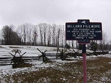
- Town of Summerhill is the present location of the birthplace of President Millard FillmoreMillard FillmoreMillard Fillmore was the 13th President of the United States and the last member of the Whig Party to hold the office of president...
. Fillmore was born in the historical Town of Locke, from which the Town of Summerhill was created.
- Elbridge G. SpauldingElbridge G. SpauldingElbridge Gerry Spaulding Elbridge Gerry Spaulding Elbridge Gerry Spaulding (February 24, 1809 - May 5, 1897 was an American lawyer, banker, and politician. He supported the idea for the first U.S...
, Congressman and New York political leader was born in Summerhill.
Geography
According to the United States Census BureauUnited States Census Bureau
The United States Census Bureau is the government agency that is responsible for the United States Census. It also gathers other national demographic and economic data...
, the town has a total area of 26 square miles (67.3 km²), of which, 25.9 square miles (67.1 km²) of it is land and 0.1 square mile (0.258998811 km²) of it (0.42%) is water.
The south town line is the border of Tompkins County
Tompkins County, New York
Tompkins County is a county located in the U.S. state of New York, and comprises the whole of the Ithaca metropolitan area. As of the 2010 census, the population was 101,564. The county seat is Ithaca, and the county is home to Cornell University, Ithaca College and Tompkins Cortland Community...
and the east town line is the border of Cortland County
Cortland County, New York
Cortland County is a county located in the U.S. state of New York, named after Federico Van Cortlandt, president of the convention at Kingston that wrote the first New York State Constitution in 1777, and first lieutenant governor of the state. The county seat is Cortland...
.
New York State Route 90
New York State Route 90
New York State Route 90 is a north–south state highway in the Finger Lakes region of New York, United States. All but five of the route's are located in Cayuga County, with the remaining situated in Cortland County. The southern terminus of the route is at an intersection with U.S....
is an east-west highway in south of Summerhill. New York State Route 41A
New York State Route 41A
New York State Route 41A is a north–south New York State Route located within Onondaga, Cayuga, and Cortland Counties in Central New York. Its northern terminus is located at a junction with U.S. Route 20 in the village of Skaneateles in Onondaga County...
crosses the northeast part of the town.
Adjacent towns and areas
The Town of SemproniusSempronius, New York
Sempronius is a town in Cayuga County, New York, USA. The population was 895 at the 2010 census. The town was named after a Roman military and political leader by a clerk interested in the classics....
is to the north and the Town of Locke
Locke, New York
Locke is a town in Cayuga County, New York, United States. The population was 1,951 at the 2010 census. The town was named after John Locke, an English philosopher and is the birthplace of Millard Fillmore, 13th President of the United States....
is to the west. The Town of Groton
Groton (town), New York
Groton is a town in Tompkins County, New York, United States. The population was 5,794 at the 2000 census. The name is taken from Groton, Connecticut.The Town of Groton contains a village, also called Groton...
in Tompkins County is on the south and the Town of Homer
Homer (town), New York
Homer is a town in Cortland County, New York, United States. The population was 6,363 at the 2000 census. The name is from the Greek poet Homer.The Town of Homer contains a village called Homer...
in Cortland County is on the east.
Demographics
As of the censusCensus
A census is the procedure of systematically acquiring and recording information about the members of a given population. It is a regularly occurring and official count of a particular population. The term is used mostly in connection with national population and housing censuses; other common...
of 2000, there were 1,098 people, 393 households, and 304 families residing in the town. The population density
Population density
Population density is a measurement of population per unit area or unit volume. It is frequently applied to living organisms, and particularly to humans...
was 42.4 people per square mile (16.4/km²). There were 463 housing units at an average density of 17.9 per square mile (6.9/km²). The racial makeup of the town was 99.27% White, 0.18% African American, 0.18% Native American, and 0.36% from two or more races. Hispanic or Latino of any race were 0.64% of the population.
There were 393 households out of which 37.4% had children under the age of 18 living with them, 60.3% were married couples
Marriage
Marriage is a social union or legal contract between people that creates kinship. It is an institution in which interpersonal relationships, usually intimate and sexual, are acknowledged in a variety of ways, depending on the culture or subculture in which it is found...
living together, 7.9% had a female householder with no husband present, and 22.6% were non-families. 16.0% of all households were made up of individuals and 6.1% had someone living alone who was 65 years of age or older. The average household size was 2.79 and the average family size was 3.06.
In the town the population was spread out with 29.2% under the age of 18, 7.6% from 18 to 24, 30.1% from 25 to 44, 23.8% from 45 to 64, and 9.3% who were 65 years of age or older. The median age was 36 years. For every 100 females there were 105.2 males. For every 100 females age 18 and over, there were 105.0 males.
The median income for a household in the town was $39,000, and the median income for a family was $39,500. Males had a median income of $26,336 versus $24,375 for females. The per capita income
Per capita income
Per capita income or income per person is a measure of mean income within an economic aggregate, such as a country or city. It is calculated by taking a measure of all sources of income in the aggregate and dividing it by the total population...
for the town was $14,609. About 6.9% of families and 12.1% of the population were below the poverty line, including 21.8% of those under age 18 and 2.0% of those age 65 or over.
Communities and locations in Summerhill
- Como – A hamlet in the northeast part of the town on NY Route 41ANew York State Route 41ANew York State Route 41A is a north–south New York State Route located within Onondaga, Cayuga, and Cortland Counties in Central New York. Its northern terminus is located at a junction with U.S. Route 20 in the village of Skaneateles in Onondaga County...
. - Empire Haven Nudist Park – Host of the Northeast Naturist Festival.
- Fall Brook – A stream flowing southward in the eastern part of Summerhill.
- Fillmore Glen State ParkFillmore Glen State ParkFillmore Glen State Park is located adjacent to the Village of Moravia in Cayuga County, New York.The primary attractions of the park are the hiking trails with views of a stream and several waterfalls, and the swimming pond, made by damming the stream...
– The state parkState parkState parks are parks or other protected areas managed at the federated state level within those nations which use "state" as a political subdivision. State parks are typically established by a state to preserve a location on account of its natural beauty, historic interest, or recreational...
in the northwest of the town (and in the Town of Locke) contains a replica of Millard Fillmore's birthplace. - Four Town Corners – A location in the northwest corner of the town.
- Halls Corners – A hamlet on the east side of the town on NY Route 90New York State Route 90New York State Route 90 is a north–south state highway in the Finger Lakes region of New York, United States. All but five of the route's are located in Cayuga County, with the remaining situated in Cortland County. The southern terminus of the route is at an intersection with U.S....
, east of Summer Hill. - Lake Como (formerly "Locke Pond") – A small lakeLakeA lake is a body of relatively still fresh or salt water of considerable size, localized in a basin, that is surrounded by land. Lakes are inland and not part of the ocean and therefore are distinct from lagoons, and are larger and deeper than ponds. Lakes can be contrasted with rivers or streams,...
west of the community of Como. - Summer Hill – The hamlet of Summer Hill is in the south part of the town on NY-90.