
.gif)
Steinbach (Taunus)
Encyclopedia
Steinbach is a town in the Hochtaunuskreis
that borders in the east on Frankfurt am Main. Other neighbouring towns are Oberursel
, Kronberg im Taunus
and Eschborn
. It is in the German
state of Hesse
.
, in the south on the town of Eschborn (Main-Taunus-Kreis
), and in the west on the town of Kronberg
.
shows a harnessed spring with two spouts out of both of which is coming water, pouring into a vat. This heraldic charge is based on an actual spring that can be found at Pijnacker Square in the town.
Steinbach was granted these arms in 1964, and their origin is wholly modern, as the town had never had arms until this time, at least as far as was known. The vat originally surrounded the spring and served to hold the water for those who needed it. This struck some as rather an odd sight, and it earned the town the nickname Steinbach in der Bütt (Bütt, or more usually Bütte, being German
for "vat").http://www.ngw.nl/int/dld/s/steinbat.htm
 Steinbach had its first documentary mention in 789 in the codex traditionum: "The Marca Steinbach goes as a donation to the Lorsch Benedictine Monastery".
From 1866 to 1945, Steinbach was a Hessian island within otherwise Prussia
n territory in the Vordertaunus (the part of the Taunus nearest Frankfurt): As the only community in Frankfurt's west, it belonged not to the Prussian-occupied Duchy of Nassau but to the Offenbach district in the Grand Duchy of Hesse, and as of the 1918 Revolution
to the People's State of Hesse. Until 1945, therefore, the community bordered on "foreign" territory at every compass point.
Out of this community grew a small town – which only 50 years earlier did not even have 1000 inhabitants – when in 1972 Steinbach was granted town rights after municipal reform.
Bells of St. George's Church
In the small, pointed turrets of St. George's Church are two bells. The oldest, the St. George bell from the year 1622 (still from the 30-year war) has a weight of 250 pounds and is in the tone "dis". Their inscription reads "I poured Joh Andr. Schneiderwin Frankfurdt 1622.
The other, which John Bell poured on 2 December 1956 by Gebr Rinker in mind weighs 220 pounds and is on the sound "f". It was created by the longtime pastor Martin Tuber consecrated.
network. The bigger towns of Oberursel, Bad Homburg vor der Höhe and Frankfurt am Main can be reached on line S5.
Two buslines connect the town core and outlying residential neighbourhoods with the railway station on the Homburger Bahn and with neighbouring places.
A few kilometres away are interchanges with Autobahnen A 5
and A 66
.
Frankfurt International Airport
is 15 km away.
and Sophie Scholl
, a brother and sister who were part of the White Rose
resistance group in Nazi Germany
.
, Netherlands
Saint-Avertin
, France
Steinbach-Hallenberg
, Thuringia
Hochtaunuskreis
The Hochtaunuskreis is a Kreis in the middle of Hesse, Germany and is part of the Frankfurt/Rhine-Main Metropolitan Region. Neighbouring districts are Lahn-Dill, Wetteraukreis, district-free Frankfurt, Main-Taunus, Rheingau-Taunus, Limburg-Weilburg.The Hochtaunuskreis and the Landkreis Starnberg...
that borders in the east on Frankfurt am Main. Other neighbouring towns are Oberursel
Oberursel
Oberursel is a town in Germany. It is located to the north west of Frankfurt, and is the second largest town in the county of Hochtaunuskreis and the 14th largest town in Hessen.-Extent of municipal area:...
, Kronberg im Taunus
Kronberg im Taunus
Kronberg im Taunus is a town in the Hochtaunuskreis district, Hesse, Germany. Before 1866, it was in the Duchy of Nassau; in that year the whole Duchy was absorbed into Prussia. Kronberg lies at the foot of the Taunus, flanked in the north and southwest by forests...
and Eschborn
Eschborn
Eschborn is a town near Frankfurt am Main in the Main-Taunus district, Hesse, Germany. As of 2009, it had a population of 20,789, but boasts fulltime employment of over 30,000 people...
. It is in the German
Germany
Germany , officially the Federal Republic of Germany , is a federal parliamentary republic in Europe. The country consists of 16 states while the capital and largest city is Berlin. Germany covers an area of 357,021 km2 and has a largely temperate seasonal climate...
state of Hesse
Hesse
Hesse or Hessia is both a cultural region of Germany and the name of an individual German state.* The cultural region of Hesse includes both the State of Hesse and the area known as Rhenish Hesse in the neighbouring Rhineland-Palatinate state...
.
Location
Steinbach is below 50 degrees 7 minutes north latitude and 28 degrees 7 minutes east longitude in the "Vordertaunus", at the Nature Park Hochtaunus and is about 7 km. Of the Frankfurt city border. In sight are heading north and west Altkönig Feldberg and to the southwest is clear visibility of the Odenwald to recognize. In the south stands the Frankfurt skyline, with sunny weather look to the Staudinger power plant in Grosskrotzenburg releases.Neighbouring communities
Steinbach borders in the north on the town of Oberursel, in the east on the district-free city of FrankfurtFrankfurt
Frankfurt am Main , commonly known simply as Frankfurt, is the largest city in the German state of Hesse and the fifth-largest city in Germany, with a 2010 population of 688,249. The urban area had an estimated population of 2,300,000 in 2010...
, in the south on the town of Eschborn (Main-Taunus-Kreis
Main-Taunus-Kreis
Main-Taunus is a Kreis in the middle of Hesse, Germany and is part of the Frankfurt/Rhine-Main Metropolitan Region as well as the Frankfurt urban area...
), and in the west on the town of Kronberg
Kronberg im Taunus
Kronberg im Taunus is a town in the Hochtaunuskreis district, Hesse, Germany. Before 1866, it was in the Duchy of Nassau; in that year the whole Duchy was absorbed into Prussia. Kronberg lies at the foot of the Taunus, flanked in the north and southwest by forests...
.
Geology
The town is surrounded by large field corridors. In the south-east, the valley of the "Steinbach" shaped the landscape, as protected landscape element expelled. The Western region with lying scattered orchards and field hedges is part of a large-priority area for nature and landscape. Toward the northwest, the Steinbacher heath forest.Village Facility
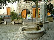
The old village was originally a circular village, whose houses in a region of 100 metres around the old wells run on today's "Pijnacker place" clustered. The local wells ( "Bütt") served the residents as a source of fresh water. (The water pipe was only 1954 - as well as the gas lines - was laid after Steinbach of the Upper Taunus district belonged. Predictions supplied by the one-house-wells or water was by hand cars from running well.) From the square, still lower and Kirchgasse and Bornhohl - in the upper lane extension -.Neighbours
- N: Taunus, Altkönig, Feldberg
- NO: Oberursel, Bad Homburg
- O: Oberursel-Stierstadt, Oberursel-Weißkirchen, S-Bahnhof
- SO: Frankfurt am Main (Niederursel, Praunheim)
- S: Frankfurt (Sossenheim, Rödelheim), Eschborn-Süd
- SW: Eschborn
- W: Niederhöchstadt, Schwalbach, Main-Taunus-Kreis
- NW: Kronberg, Oberhöchstadt
Coat of arms
Steinbach's civic coat of armsCoat of arms
A coat of arms is a unique heraldic design on a shield or escutcheon or on a surcoat or tabard used to cover and protect armour and to identify the wearer. Thus the term is often stated as "coat-armour", because it was anciently displayed on the front of a coat of cloth...
shows a harnessed spring with two spouts out of both of which is coming water, pouring into a vat. This heraldic charge is based on an actual spring that can be found at Pijnacker Square in the town.
Steinbach was granted these arms in 1964, and their origin is wholly modern, as the town had never had arms until this time, at least as far as was known. The vat originally surrounded the spring and served to hold the water for those who needed it. This struck some as rather an odd sight, and it earned the town the nickname Steinbach in der Bütt (Bütt, or more usually Bütte, being German
German language
German is a West Germanic language, related to and classified alongside English and Dutch. With an estimated 90 – 98 million native speakers, German is one of the world's major languages and is the most widely-spoken first language in the European Union....
for "vat").http://www.ngw.nl/int/dld/s/steinbat.htm
History
From 1866 to 1945, Steinbach was a Hessian island within otherwise Prussia
Prussia
Prussia was a German kingdom and historic state originating out of the Duchy of Prussia and the Margraviate of Brandenburg. For centuries, the House of Hohenzollern ruled Prussia, successfully expanding its size by way of an unusually well-organized and effective army. Prussia shaped the history...
n territory in the Vordertaunus (the part of the Taunus nearest Frankfurt): As the only community in Frankfurt's west, it belonged not to the Prussian-occupied Duchy of Nassau but to the Offenbach district in the Grand Duchy of Hesse, and as of the 1918 Revolution
German Revolution
The German Revolution was the politically-driven civil conflict in Germany at the end of World War I, which resulted in the replacement of Germany's imperial government with a republic...
to the People's State of Hesse. Until 1945, therefore, the community bordered on "foreign" territory at every compass point.
Out of this community grew a small town – which only 50 years earlier did not even have 1000 inhabitants – when in 1972 Steinbach was granted town rights after municipal reform.
Sights
Steinbach is in the "Rhein-Main-Gebiet" and has not many historic buildings, but here is a small Overview: In the heart of Steinbach stone on the court Pijnacker: Here is the symbol "Bütt", a well run, jump out of the Steinbach fed. Framed this is the center of the two inns "Zum Goldenen Stern" and "Zum Schwanen", with its monumental timbered facade. Both bars have a very long tradition. The oldest restaurant in Steinbach "Zum Taunus" in the Bornhohl no longer exists. In the Kirchgasse, is the back house, nor by the old custom of baking bread itself. The back rooms of the house, but also for various exhibitions and lectures. There is also a "Trauzimmer". The St. George's Church (Protestant) is next to the back house. It was built 1537 as the first Protestant church in Germany at the direction of Caspar Kronberg of the second century. In Steinbach, there are some old buildings, by the bronze plates on the Built and other important details to report, such as the old "Schultheißenhaus" in "Bornhohl", which was first documented in 1549 as a house of "Schultheißenamtes" was mentioned in today monument. Interesting and historically valuable is the house Untergasse 2 by 1782 to 1856 Johann Christoph Diehl lived, the teacher from Frederick Stolze. A bronze plate reminiscent of the former Steinbacher. Change of location: The first of the Oak Forest City Steinbacher is a tree monument. It is the most southerly of the Taunus oak.Bells of St. George's Church
In the small, pointed turrets of St. George's Church are two bells. The oldest, the St. George bell from the year 1622 (still from the 30-year war) has a weight of 250 pounds and is in the tone "dis". Their inscription reads "I poured Joh Andr. Schneiderwin Frankfurdt 1622.
The other, which John Bell poured on 2 December 1956 by Gebr Rinker in mind weighs 220 pounds and is on the sound "f". It was created by the longtime pastor Martin Tuber consecrated.
Population Development
| Year | Population |
|---|---|
| 1535 | 31 |
| 1750 | 220 |
| 1853 | 600 |
| 1945 | 1492 |
| 1960 | 1713 |
| 1965 | 4089 |
| 1975 | 10642 |
| 1985 | 10440 |
| 2007 | 10005 |
Transport
Steinbach is distinguished by not having a direct road link to Frankfurt. Through Oberursel-Weißkirchen/Steinbach station, however, it is joined to the RMV S-BahnS-Bahn
S-Bahn refers to an often combined city center and suburban railway system metro in Austria, Germany, Switzerland and Denmark...
network. The bigger towns of Oberursel, Bad Homburg vor der Höhe and Frankfurt am Main can be reached on line S5.
Two buslines connect the town core and outlying residential neighbourhoods with the railway station on the Homburger Bahn and with neighbouring places.
A few kilometres away are interchanges with Autobahnen A 5
Bundesautobahn 5
is a 445 km long Autobahn in Germany. Its northern end is the Hattenbach triangle intersection is a 445 km (277 mi) long Autobahn in Germany. Its northern end is the Hattenbach triangle intersection is a 445 km (277 mi) long Autobahn in Germany. Its northern end is the...
and A 66
Bundesautobahn 66
is an autobahn in southwestern Germany. It connects the Taunus to Fulda, passing close to Frankfurt am Main. The first part of the autobahn between Wiesbaden and the Nordwestkreuz Frankfurt, was opened as early as 1934, then called the Rhein-Main-Schnellweg. It became an autobahn in 1965.The...
.
Frankfurt International Airport
Frankfurt International Airport
Frankfurt am Main Airport , or simply Frankfurt Airport, known in German as Flughafen Frankfurt am Main or Rhein-Main-Flughafen, is a major international airport located in Frankfurt, Germany, southwest of the city centre....
is 15 km away.
Educational institutions
Steinbach is home to the Geschwister-Scholl-Grundschule, a primary school named after HansHans Scholl
Hans Fritz Scholl was a founding member of the White Rose resistance movement in Nazi Germany.-Biography:...
and Sophie Scholl
Sophie Scholl
Sophia Magdalena Scholl was a German student, active within the White Rose non-violent resistance group in Nazi Germany. She was convicted of high treason after having been found distributing anti-war leaflets at the University of Munich with her brother Hans...
, a brother and sister who were part of the White Rose
White Rose
The White Rose was a non-violent/intellectual resistance group in Nazi Germany, consisting of students from the University of Munich and their philosophy professor...
resistance group in Nazi Germany
Nazi Germany
Nazi Germany , also known as the Third Reich , but officially called German Reich from 1933 to 1943 and Greater German Reich from 26 June 1943 onward, is the name commonly used to refer to the state of Germany from 1933 to 1945, when it was a totalitarian dictatorship ruled by...
.
Partnerships
Steinbach maintains partnership links with the following places: PijnackerPijnacker
Pijnacker is a town in the Dutch province of South Holland. It is located about 4 km east of the city of Delft, in the municipality of Pijnacker-Nootdorp....
, Netherlands
Netherlands
The Netherlands is a constituent country of the Kingdom of the Netherlands, located mainly in North-West Europe and with several islands in the Caribbean. Mainland Netherlands borders the North Sea to the north and west, Belgium to the south, and Germany to the east, and shares maritime borders...
Saint-Avertin
Saint-Avertin
Saint-Avertin is a commune in the Indre-et-Loire department in central France.-References:* In the Gallo-Roman times, a hamlet called Vinciacum was set up near quarries where stones required for the building of Caesarodonum were extracted. The village took later the name of Vinçay. In 1162, St...
, France
France
The French Republic , The French Republic , The French Republic , (commonly known as France , is a unitary semi-presidential republic in Western Europe with several overseas territories and islands located on other continents and in the Indian, Pacific, and Atlantic oceans. Metropolitan France...
Steinbach-Hallenberg
Steinbach-Hallenberg
Steinbach-Hallenberg is a town in the Schmalkalden-Meiningen district, in Thuringia, Germany. It is situated in the Thuringian Forest, 8 km east of Schmalkalden, and 13 km northwest of Suhl.-References:-External links:*...
, Thuringia
Thuringia
The Free State of Thuringia is a state of Germany, located in the central part of the country.It has an area of and 2.29 million inhabitants, making it the sixth smallest by area and the fifth smallest by population of Germany's sixteen states....