
.gif)
State Route 201 (Utah)
Encyclopedia
State Route 201 is an east–west expressway
and freeway located in Salt Lake County
in the U.S. state
of Utah
. Colloquially known as the 21st South Freeway, the route serves as an alternative to Interstate 80
(I-80) through Salt Lake City. From the western terminus of the route west of Magna
, the highway heads east through Kennecott Copper
property as an expressway before running through the western suburbs of Salt Lake City as a freeway. Shortly after the route returns on a surface route, SR-201 terminates on its eastern end at U.S. Route 89
(US-89, State Street).
The history of the route predates the invention of the automobile; the Donner Party
, California Trail
and Pony Express
all followed the present-day path of the highway. During the 1910s, the route was designated a state highway and, in 1939, State Route 201 was officially written into law, running from Magna
east to the mouth of Parley's Canyon
. At one point, the highway carried US-50 Alternate
west of State Street and both US-40
and US-40 Alternate
east of that road, though all were truncated from Salt Lake City by the late 1970s. Construction of the freeway portion of SR-201 west of I-15
commenced in the mid-1960s and was fully completed by 1986.
 At its western terminus, SR-201 begins at a partial interchange at I-80
. Heading generally east with two lanes in each direction, the expressway passes by the Kennecott
Smokestack
, the tallest structure in Utah. Past its intersection at SR-202, the route takes a turn to the southeast, bypassing the Kennecott tailings pond
. Now exiting Kennecott property, the route exits unpopulated terrain and enters the urban Wasatch Front
, beginning with the Salt Lake City suburb of Magna
. Past junctions at 9200 West, 8400 West, 8000 West and 7200 West, the route veers northerly three blocks and becomes a limited-access freeway. East of 7200 West, SR-201 is routed at approximately 2100 South in Salt Lake County's grid system, giving the freeway its nickname of "21st South Freeway".
Now with three lanes in each direction, the highway straddles the boundary between Salt Lake City and West Valley City
, another suburb of the former. The road continues due east with diamond interchange
s at 5600 West (SR-172) and Bangerter Highway (SR-154). Immediately following a single-point urban interchange
(SPUI) at 3200 West, the freeway intersects I-215
in the form of a cloverleaf interchange
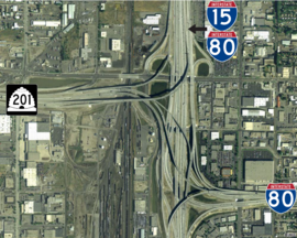
. The road dips to the south slightly and, following two SPUIs at Redwood Road (SR-68) and 900 West, the freeway terminates at the Spaghetti Bowl
interchange, giving eastbound motorists on SR-201 the option of continuing to I-15, I-80, 1300 South and 900 South. However, an eastbound traveler wanting to continue on the surface portion of SR-201 to State Street must exit on 900 West, head north briefly and then turn eastbound on 2100 South; a westbound traveler on 2100 South wishing to connect to the freeway must take an on-ramp from the surface street just before 900 West. Prior to 1997, this connection was direct. Now on the four-lane 2100 South, a secondary surface street, the route runs along the Salt Lake City–South Salt Lake
border. State maintenance of 2100 South ends at the intersection of State Street (US-89).
, Pony Express
and Lincoln Highway
. While signed as the route of the California Trail, modern 2100 South is a less common branch called Hastings Cutoff
that became infamous because of the Donner Party
. The Lincoln Highway, generally derived from the route of the Pony Express across Utah, was routed on 2100 South. However, no modern highway exactly follows the route of the Pony Express west of Salt Lake City. SR-201 is one of a few auto-tour routes that approximates the Pony Express trail, which actually ran south of the road.
In the 1910s, 2100 South in Salt Lake County
became an unnumbered state highway. In 1919, when the state legislature redefined the state road system to include only a short list given in the law and any federal aid projects, 2100 South east of State Street remained as a portion of the Lincoln Highway
. In 1926, 2100 South became part of US-40, following the creation of the United States Numbered Highway
system. By 1937, 2100 South west of 9180 West was assigned to US-50, US-40 now turning northward toward Downtown Salt Lake City. This created two signed highways over 2100 South: US-40 east of US-91 and US-50 east of 9200 West (US-50 traveled west on 3500 South through Salt Lake City from US-91 to 2100 South in Magna, whereas US-40 turned from eastbound 2100 South to northbound State Street to connect to North Temple).
In 1939, the state legislature designated State Route 201, running west on 2100 South from State Street (US-40/US-91) to US-50 (9180 West) in Magna. By 1954, US-50 was moved south to an alignment through central Utah, the old routing mostly replaced by US-50 Alternate (US-50A). However, US-50A was placed in Salt Lake City on 2100 South west of State Street, replacing the SR-201 designation.
By 1965, US-40 was realigned along Foothill Drive (then US-40A), the Utah Highway Department believing the Foothill route was more direct in connecting with North Temple toward the airport. US-40A was now aligned along the entirety of 2100 South from US-40/future I-215 at the mouth of Parley's Canyon west to State Street and beyond with US-50A to US-40 west of Magna. Both mainline and Alternate US-40, along with US-50A, were truncated to east of the city by 1979.
. From under-construction I-15 west to Redwood Road, the old route of SR-201 was being superseded by a six-lane freeway directly to the south. All construction was complete by 1970 with interchanges at 900 West and Redwood Road; the new freeway extended west to 2700 West.
By 1977, an interchange directly west of Redwood Road at I-215 was being built and the rest of the highway to Magna was given a median in preparation for freeway construction to 5600 West (SR-172). This construction concluded by 1986, with interchanges at 3200 West, Bangerter Highway (SR-154, then solely 4000 West) and 5600 West as a result. Beginning in April 1997 and concluding in July 2001, as part of a larger reconstruction project for I-15, SR-201 was rebuilt from 900 West to I-15/I-80, including the colloquial Spaghetti Bowl
interchange. As a result, SR-201 was left in two discontinuous pieces; to connect from the surface portion of SR-201 to the freeway, one must now take an on-ramp. From 2004 to 2006, the freeway from 900 West to I-215 was widened and repaved, the Redwood Road interchange being redone as well. In 2009, the freeway from Bangerter Highway to 5600 West was widened to three lanes in each direction and the road between SR-202 and I-80 was widened to four lanes—the latter project eliminated the final two-lane section of SR-201.
.
{|class=wikitable
|-
!Location
!Mile
!#
!Road(s)
!Notes
|-
|Lake Point Junction
|0.000
|
|
|Westbound exit and eastbound entrance
|-
|Garfield
|3.250
|
| – Great Salt Lake State Park
|
|-
|Magna
|7.179
|
|, Bingham Canyon Mine
|
|-
|rowspan=13|Salt Lake City
|colspan=4|West end of freeway
|-
|10.805
|11
|
|
|-
|12.821
|13
|
|
|-
|13.760
|14
|3200 West
|
|-
|14.418
|15A
|
|
|-
|14.762
|15B
|
|
|-
|15.287
|15C
|
|
|-
|16.414
|17
|900 West
|SR-201 connects to 2100 South via this exit
|-
|
|
|, Reno
, Las Vegas
, Cheyenne
|
|-
|colspan=4|East end of freeway
|-
|17.196
|
| – Las Vegas
|
|-
|17.384
|
| – Salt Lake City, Reno
|
|-
|18.095
|
|
|Former US-91
Limited-access road
A limited-access road known by various terms worldwide, including limited-access highway, dual-carriageway and expressway, is a highway or arterial road for high-speed traffic which has many or most characteristics of a controlled-access highway , including limited or no access to adjacent...
and freeway located in Salt Lake County
Salt Lake County, Utah
Salt Lake County is a county located in the U.S. state of Utah. It had a population of 1,029,655 at the 2010 census. Its county seat and largest city is Salt Lake City, the state capital. It occupies Salt Lake Valley, as well as parts of the surrounding mountains, the Oquirrh Mountains to the west...
in the U.S. state
U.S. state
A U.S. state is any one of the 50 federated states of the United States of America that share sovereignty with the federal government. Because of this shared sovereignty, an American is a citizen both of the federal entity and of his or her state of domicile. Four states use the official title of...
of Utah
Utah
Utah is a state in the Western United States. It was the 45th state to join the Union, on January 4, 1896. Approximately 80% of Utah's 2,763,885 people live along the Wasatch Front, centering on Salt Lake City. This leaves vast expanses of the state nearly uninhabited, making the population the...
. Colloquially known as the 21st South Freeway, the route serves as an alternative to Interstate 80
Interstate 80 in Utah
In the U.S. state of Utah, Interstate 80 runs east–west through northern part of the state, passing through the Bonneville Salt Flats, the Salt Lake City metropolitan area, the Wasatch Mountains and Echo canyon. In western Utah the highway was built along the corridor of the Victory...
(I-80) through Salt Lake City. From the western terminus of the route west of Magna
Magna, Utah
Magna is a census-designated place and township in Salt Lake County, Utah, United States. The population was 26,505 at the 2010 census, a moderate increase over the 2000 figure of 22,770...
, the highway heads east through Kennecott Copper
Kennecott Utah Copper
Kennecott Utah Copper Corporation , a division of Rio Tinto Group, is a mining, smelting, and refining company. Its corporate headquarters are located in South Jordan, Utah, USA. Kennecott operates one of the largest open-pit copper mines in the world in Bingham Canyon, Salt Lake County, Utah. ...
property as an expressway before running through the western suburbs of Salt Lake City as a freeway. Shortly after the route returns on a surface route, SR-201 terminates on its eastern end at U.S. Route 89
U.S. Route 89 in Utah
In the U.S. state of Utah, U.S. Route 89 is a long north–south state highway spanning more than through the central part of the state. Between Provo and Brigham City, US-89 serves as a local road, paralleling Interstate 15, but the portions from Arizona north to Provo and Brigham City...
(US-89, State Street).
The history of the route predates the invention of the automobile; the Donner Party
Donner Party
The Donner Party was a group of American pioneers who set out for California in a wagon train. Delayed by a series of mishaps, they spent the winter of 1846–47 snowbound in the Sierra Nevada...
, California Trail
California Trail
The California Trail was an emigrant trail of about across the western half of the North American continent from Missouri River towns to what is now the state of California...
and Pony Express
Pony Express
The Pony Express was a fast mail service crossing the Great Plains, the Rocky Mountains, and the High Sierra from St. Joseph, Missouri, to Sacramento, California, from April 3, 1860 to October 1861...
all followed the present-day path of the highway. During the 1910s, the route was designated a state highway and, in 1939, State Route 201 was officially written into law, running from Magna
Magna, Utah
Magna is a census-designated place and township in Salt Lake County, Utah, United States. The population was 26,505 at the 2010 census, a moderate increase over the 2000 figure of 22,770...
east to the mouth of Parley's Canyon
Parley's Canyon
Parley's Canyon is a canyon located in the U.S. state of Utah. The canyon provides the route of Interstate 80 up the western slope of the Wasatch Mountains and is a relatively wide, straight canyon. The lower part of the canyon, however, is relatively twisty and had to be dynamited to make way for...
. At one point, the highway carried US-50 Alternate
U.S. Route 50 in Utah
The Utah portion of U.S. Route 50, commonly abbreviated US-50, crosses the center of the state. The highway serves no major population centers in Utah, with the largest city along its path being Delta. Most of the route passes through desolate, remote areas. Through the eastern half of the state...
west of State Street and both US-40
U.S. Route 40 in Utah
The west end of U.S. Route 40 is in the U.S. state of Utah at Silver Creek Junction with Interstate 80. From there it heads southeast through Heber City and east into Colorado on its way to the Mid-Atlantic.-Route description:U.S...
and US-40 Alternate
U.S. Route 40 in Utah
The west end of U.S. Route 40 is in the U.S. state of Utah at Silver Creek Junction with Interstate 80. From there it heads southeast through Heber City and east into Colorado on its way to the Mid-Atlantic.-Route description:U.S...
east of that road, though all were truncated from Salt Lake City by the late 1970s. Construction of the freeway portion of SR-201 west of I-15
Interstate 15 in Utah
In the U.S. state of Utah, Interstate 15 runs north–south through the southwestern and central portions of the state, passing through many of the population centers of that state, including St. George, Provo, Salt Lake City, and Ogden, the latter three being part of the urban area known as...
commenced in the mid-1960s and was fully completed by 1986.
Route description
Interstate 80 in Utah
In the U.S. state of Utah, Interstate 80 runs east–west through northern part of the state, passing through the Bonneville Salt Flats, the Salt Lake City metropolitan area, the Wasatch Mountains and Echo canyon. In western Utah the highway was built along the corridor of the Victory...
. Heading generally east with two lanes in each direction, the expressway passes by the Kennecott
Kennecott Utah Copper
Kennecott Utah Copper Corporation , a division of Rio Tinto Group, is a mining, smelting, and refining company. Its corporate headquarters are located in South Jordan, Utah, USA. Kennecott operates one of the largest open-pit copper mines in the world in Bingham Canyon, Salt Lake County, Utah. ...
Smokestack
Kennecott Smokestack
The Kennecott Smokestack is a 1,215 ft. high smokestack west of Magna, Utah, along SR-201 near the Great Salt Lake. It was built in order to spread the exhaust gases far away from the area of the Kennecott smelter for copper...
, the tallest structure in Utah. Past its intersection at SR-202, the route takes a turn to the southeast, bypassing the Kennecott tailings pond
Tailings
Tailings, also called mine dumps, slimes, tails, leach residue, or slickens, are the materials left over after the process of separating the valuable fraction from the uneconomic fraction of an ore...
. Now exiting Kennecott property, the route exits unpopulated terrain and enters the urban Wasatch Front
Wasatch Front
The Wasatch Front is a metropolitan region in the north-central part of the U.S. state of Utah. It consists of a chain of cities and towns stretched along the Wasatch Range from approximately Santaquin in the south to Brigham City in the north...
, beginning with the Salt Lake City suburb of Magna
Magna, Utah
Magna is a census-designated place and township in Salt Lake County, Utah, United States. The population was 26,505 at the 2010 census, a moderate increase over the 2000 figure of 22,770...
. Past junctions at 9200 West, 8400 West, 8000 West and 7200 West, the route veers northerly three blocks and becomes a limited-access freeway. East of 7200 West, SR-201 is routed at approximately 2100 South in Salt Lake County's grid system, giving the freeway its nickname of "21st South Freeway".
Now with three lanes in each direction, the highway straddles the boundary between Salt Lake City and West Valley City
West Valley City, Utah
West Valley City is a city in Salt Lake County and a suburb of Salt Lake City in the U.S. state of Utah. The population was 129,480 at the 2010 census,...
, another suburb of the former. The road continues due east with diamond interchange
Diamond interchange
A diamond interchange is a common type of road junction, used where a freeway crosses a minor road. The freeway itself is grade-separated from the minor road, one crossing the other over a bridge...
s at 5600 West (SR-172) and Bangerter Highway (SR-154). Immediately following a single-point urban interchange
Single-point urban interchange
A single-point urban interchange , also called a single-point interchange or single-point diamond interchange , is a type of highway interchange...
(SPUI) at 3200 West, the freeway intersects I-215
Interstate 215 (Utah)
Interstate 215 , also known locally as the belt route or two-fifteen, is an auxiliary interstate in the U.S. state of Utah that forms a 270-degree loop around Salt Lake City and many of its suburbs...
in the form of a cloverleaf interchange
Cloverleaf interchange
A cloverleaf interchange is a two-level interchange in which left turns, reverse direction in left-driving regions, are handled by ramp roads...
. The road dips to the south slightly and, following two SPUIs at Redwood Road (SR-68) and 900 West, the freeway terminates at the Spaghetti Bowl
Spaghetti Bowl
Spaghetti Bowl is a term used to describe a network of highway interconnects that looks like spaghetti in a bowl when viewed from overhead, also known as a Spaghetti Junction. The name is frequently only used by locals...
interchange, giving eastbound motorists on SR-201 the option of continuing to I-15, I-80, 1300 South and 900 South. However, an eastbound traveler wanting to continue on the surface portion of SR-201 to State Street must exit on 900 West, head north briefly and then turn eastbound on 2100 South; a westbound traveler on 2100 South wishing to connect to the freeway must take an on-ramp from the surface street just before 900 West. Prior to 1997, this connection was direct. Now on the four-lane 2100 South, a secondary surface street, the route runs along the Salt Lake City–South Salt Lake
South Salt Lake, Utah
South Salt Lake is a city in Salt Lake County, Utah, United States, part of the Salt Lake City, Utah Metropolitan Statistical Area. The population was 23,617 at the 2010 census.-History:...
border. State maintenance of 2100 South ends at the intersection of State Street (US-89).
History
State Route 201 is one of the original highways through the Salt Lake Valley. Signs along the route claim the path of the highway to be the historical route of the California TrailCalifornia Trail
The California Trail was an emigrant trail of about across the western half of the North American continent from Missouri River towns to what is now the state of California...
, Pony Express
Pony Express
The Pony Express was a fast mail service crossing the Great Plains, the Rocky Mountains, and the High Sierra from St. Joseph, Missouri, to Sacramento, California, from April 3, 1860 to October 1861...
and Lincoln Highway
Lincoln Highway
The Lincoln Highway was the first road across the United States of America.Conceived and promoted by entrepreneur Carl G. Fisher, the Lincoln Highway spanned coast-to-coast from Times Square in New York City to Lincoln Park in San Francisco, originally through 13 states: New York, New Jersey,...
. While signed as the route of the California Trail, modern 2100 South is a less common branch called Hastings Cutoff
Hastings Cutoff
The Hastings Cutoff was an alternate route for emigrants to travel to California, as proposed by Lansford Hastings.In 1845, Hastings published a guide entitled The Emigrant's Guide to Oregon and California...
that became infamous because of the Donner Party
Donner Party
The Donner Party was a group of American pioneers who set out for California in a wagon train. Delayed by a series of mishaps, they spent the winter of 1846–47 snowbound in the Sierra Nevada...
. The Lincoln Highway, generally derived from the route of the Pony Express across Utah, was routed on 2100 South. However, no modern highway exactly follows the route of the Pony Express west of Salt Lake City. SR-201 is one of a few auto-tour routes that approximates the Pony Express trail, which actually ran south of the road.
In the 1910s, 2100 South in Salt Lake County
Salt Lake County, Utah
Salt Lake County is a county located in the U.S. state of Utah. It had a population of 1,029,655 at the 2010 census. Its county seat and largest city is Salt Lake City, the state capital. It occupies Salt Lake Valley, as well as parts of the surrounding mountains, the Oquirrh Mountains to the west...
became an unnumbered state highway. In 1919, when the state legislature redefined the state road system to include only a short list given in the law and any federal aid projects, 2100 South east of State Street remained as a portion of the Lincoln Highway
Lincoln Highway
The Lincoln Highway was the first road across the United States of America.Conceived and promoted by entrepreneur Carl G. Fisher, the Lincoln Highway spanned coast-to-coast from Times Square in New York City to Lincoln Park in San Francisco, originally through 13 states: New York, New Jersey,...
. In 1926, 2100 South became part of US-40, following the creation of the United States Numbered Highway
United States Numbered Highways
The system of United States Numbered Highways is an integrated system of roads and highways in the United States numbered within a nationwide grid...
system. By 1937, 2100 South west of 9180 West was assigned to US-50, US-40 now turning northward toward Downtown Salt Lake City. This created two signed highways over 2100 South: US-40 east of US-91 and US-50 east of 9200 West (US-50 traveled west on 3500 South through Salt Lake City from US-91 to 2100 South in Magna, whereas US-40 turned from eastbound 2100 South to northbound State Street to connect to North Temple).
In 1939, the state legislature designated State Route 201, running west on 2100 South from State Street (US-40/US-91) to US-50 (9180 West) in Magna. By 1954, US-50 was moved south to an alignment through central Utah, the old routing mostly replaced by US-50 Alternate (US-50A). However, US-50A was placed in Salt Lake City on 2100 South west of State Street, replacing the SR-201 designation.
By 1965, US-40 was realigned along Foothill Drive (then US-40A), the Utah Highway Department believing the Foothill route was more direct in connecting with North Temple toward the airport. US-40A was now aligned along the entirety of 2100 South from US-40/future I-215 at the mouth of Parley's Canyon west to State Street and beyond with US-50A to US-40 west of Magna. Both mainline and Alternate US-40, along with US-50A, were truncated to east of the city by 1979.
Constructing a freeway
By 1958, SR-201 between US-40 west of Magna and SR-68 (Redwood Road) was a two-lane highway through rural Salt Lake County. The rural landscape changed by the time SR-201 intersected 300 West and entered urban Salt Lake County, the highway becoming a four-lane road. The route remained this way until the intersection of 1300 East (SR-181), where the route reverted to a two-lane configuration. By 1965, a time when most U.S. Routes in the city were being replaced by Interstate Highways, all two-lane portions of the road east of 1300 East were widened to at least four lanes; an interchange between US-40, US-40A and future I-215 was being built at the mouth of Parley's CanyonParley's Canyon
Parley's Canyon is a canyon located in the U.S. state of Utah. The canyon provides the route of Interstate 80 up the western slope of the Wasatch Mountains and is a relatively wide, straight canyon. The lower part of the canyon, however, is relatively twisty and had to be dynamited to make way for...
. From under-construction I-15 west to Redwood Road, the old route of SR-201 was being superseded by a six-lane freeway directly to the south. All construction was complete by 1970 with interchanges at 900 West and Redwood Road; the new freeway extended west to 2700 West.
By 1977, an interchange directly west of Redwood Road at I-215 was being built and the rest of the highway to Magna was given a median in preparation for freeway construction to 5600 West (SR-172). This construction concluded by 1986, with interchanges at 3200 West, Bangerter Highway (SR-154, then solely 4000 West) and 5600 West as a result. Beginning in April 1997 and concluding in July 2001, as part of a larger reconstruction project for I-15, SR-201 was rebuilt from 900 West to I-15/I-80, including the colloquial Spaghetti Bowl
Spaghetti Bowl
Spaghetti Bowl is a term used to describe a network of highway interconnects that looks like spaghetti in a bowl when viewed from overhead, also known as a Spaghetti Junction. The name is frequently only used by locals...
interchange. As a result, SR-201 was left in two discontinuous pieces; to connect from the surface portion of SR-201 to the freeway, one must now take an on-ramp. From 2004 to 2006, the freeway from 900 West to I-215 was widened and repaved, the Redwood Road interchange being redone as well. In 2009, the freeway from Bangerter Highway to 5600 West was widened to three lanes in each direction and the road between SR-202 and I-80 was widened to four lanes—the latter project eliminated the final two-lane section of SR-201.
Major intersections
The entire route is in Salt Lake CountySalt Lake County, Utah
Salt Lake County is a county located in the U.S. state of Utah. It had a population of 1,029,655 at the 2010 census. Its county seat and largest city is Salt Lake City, the state capital. It occupies Salt Lake Valley, as well as parts of the surrounding mountains, the Oquirrh Mountains to the west...
.
{|class=wikitable
|-
!Location
!Mile
!#
Exit number
An exit number is a number assigned to a road junction, usually an exit from a freeway. It is usually marked on the same sign as the destinations of the exit, as well as a sign in the gore....
!Road(s)
!Notes
|-
|Lake Point Junction
|0.000
|
|
|Westbound exit and eastbound entrance
|-
|Garfield
|3.250
|
| – Great Salt Lake State Park
Great Salt Lake State Park
The Great Salt Lake State Marina is a state park in Salt Lake County, Utah.Great Salt Lake State Marina is located at an elevation of 4200 feet, on the south shore of the Great Salt Lake, 16 miles west of Salt Lake City....
|
|-
|Magna
Magna, Utah
Magna is a census-designated place and township in Salt Lake County, Utah, United States. The population was 26,505 at the 2010 census, a moderate increase over the 2000 figure of 22,770...
|7.179
|
|, Bingham Canyon Mine
Bingham Canyon Mine
The Bingham Canyon Mine, also known as the Kennecott Copper Mine, is an open-pit mining operation extracting a large porphyry copper deposit southwest of Salt Lake City, Utah, USA, in the Oquirrh Mountains. It is the deepest open-pit mine in the world. The mine is owned by Rio Tinto Group, an...
|
|-
|rowspan=13|Salt Lake City
|colspan=4|
|-
|10.805
|11
|
|
|-
|12.821
|13
|
|
|-
|13.760
|14
|3200 West
|
|-
|14.418
|15A
|
|
|-
|14.762
|15B
|
|
|-
|15.287
|15C
|
|
|-
|16.414
|17
|900 West
|SR-201 connects to 2100 South via this exit
|-
|
|
|, Reno
Reno, Nevada
Reno is the county seat of Washoe County, Nevada, United States. The city has a population of about 220,500 and is the most populous Nevada city outside of the Las Vegas metropolitan area...
, Las Vegas
Las Vegas, Nevada
Las Vegas is the most populous city in the U.S. state of Nevada and is also the county seat of Clark County, Nevada. Las Vegas is an internationally renowned major resort city for gambling, shopping, and fine dining. The city bills itself as The Entertainment Capital of the World, and is famous...
, Cheyenne
Cheyenne, Wyoming
Cheyenne is the capital and most populous city of the U.S. state of Wyoming and the county seat of Laramie County. It is the principal city of the Cheyenne, Wyoming, Metropolitan Statistical Area which encompasses all of Laramie County. The population is 59,466 at the 2010 census. Cheyenne is the...
|
|-
|colspan=4|
|-
|17.196
|
| – Las Vegas
Las Vegas, Nevada
Las Vegas is the most populous city in the U.S. state of Nevada and is also the county seat of Clark County, Nevada. Las Vegas is an internationally renowned major resort city for gambling, shopping, and fine dining. The city bills itself as The Entertainment Capital of the World, and is famous...
|
|-
|17.384
|
| – Salt Lake City, Reno
Reno, Nevada
Reno is the county seat of Washoe County, Nevada, United States. The city has a population of about 220,500 and is the most populous Nevada city outside of the Las Vegas metropolitan area...
|
|-
|18.095
|
|
|Former US-91