
.gif)
State Road 40 (Florida)
Encyclopedia
State Road 40 is an east–west route across central Florida, running from US 41 in Rainbow Lake Estates
eastwards through Ocala
over the Ocklawaha River
and bridge and through the heart of the Ocala National Forest
to State Road A1A
in Ormond Beach
. Names of the road include Silver Springs Boulevard in Ocala, Fort Brooks Road from Silver Springs through Astor, Butler Road in Astor, and Granada Boulevard in Ormond Beach. Former sections in Ormond Beach are named "Old Tomoka Road" and "Old Tomoka Avenue."
begins at US 41 north of the entrance to Rainbow Springs State Park
, where it moves at a northeast angle before crossing under a narrow railroad bridge. The road passes by the Ocala International Airport
before entering the city limits and crossing under Interstate 75
at Exit 352. East of I-75 SR 40 continues as a four-lane divided highway where it passes the Region #5 Headquarters of the Florida Department of Transportation
. CSX's S-Line, which once carried the Amtrak Palmetto runs beneath the road before intersecting with US 27
-301
-441
. East of the triplex, SR 40 climbs a hill and passes just north of the Ocala Historic Commercial District
, and south of the Ocala Union Station
. At the intersection of Northeast 25th Street SR 40 turns northeast where it serves as the western terminus of Marion CR 314(Northeast 7th Street) and the eastern terminus of Florida State Road 492 (Northeast 14th Street).
From there, the road enters Silver Springs, Florida
where it intersects with the northern terminus of Florida State Road 35
and southern terminus of Marion County Road 35 at the Silver Springs Nature Theme Park
. The road runs along the north side of Silver River State Park
, where it serves as the eastern terminus of Florida State Road 326 and the southern terminus of Marion CR 315, before it climbs the Bert Dosh Memorial Bridge
in order to cross the Ocklawaha River
, which was also intended to be part of the Cross Florida Barge Canal
, and is now part of the Cross Florida Greenway and the Florida National Scenic Trail
. From there, the highway intersects Marion CR 314 for the second time, and then Marion CR 314A, before it bisects the Ocala National Forest
. Toward the eastern edge of the Ocala National Forest, SR 40 approaches Astor Park
, where it intersects Florida State Road 19
. Immediately after the SR 19 intersection, the road crosses the Marion-Lake County
line and runs along an overlook at Wildcat Lake. East of the intersection of Lake CR 445 & CR 445A in Astor, it crosses the St. Johns River
via the Astor Bridge, approaching Lake George State Forest
in Volusia
and Pierson
. Immediately across the bridge, on the east bank of the St. Johns River, SR 40 passes through the unincorporated community of Volusia
, one the first European settlements in Florida, and the area for which Volusia, County
was named.
As the road leaves Pierson and enters Barberville
, it shifts to the northeast at the intersection of Lemmon Road, then intersects Volusia CR 3 and then the Barberville Flea Market and Post Office before a railroad crossing for the CSX "A" line a block west of the intersection of U.S. Route 17
. The road curves back east, and then northeast again as it passes along the south side of Volusia Speedway Park
before the intersection of Florida State Road 11 in DeLeon Springs
. From there, the road bisects the Tomoka Wildlife Management Area Union-Camp Tract and, after passing by some residential areas and intersecting Country Acres Boulevard, the road goes from two lanes to four as turns back into a divided highway. Despite officially entering the City of Ormond Beach
, the highway runs along the north side of Tiger Bay State Forest
and the Dan Rice Airport, but then becomes more suburban as it approaches the vicinity of the Tomoka River
just before Interstate 95
at Exit 268 which is a block away from Volusia CR 4009.
 East of I-95 & CR 4009, the road curves northeast again as it runs along residential areas along the Tomoka River
, until it curves east before crossing over a bridge over one of its tributaries, just west of the intersection of Florida State Road 5A
(North and South Nova Road). The road makes one last left curve at Old Tomoka Avenue before approaching the grade crossing of the Florida East Coast Railroad main line, and then intersects with US 1
(North and South Yonge Street). The route continues, but the divider ends as SR 40 comes in close proximity to Ormond Beach City Hall on the southwest corner of Granada Boulevard and Beach Street(CR 4011). From there, SR 40 is overlapped by the Ormond Scenic Loop and Trail
, where the divider begins again on the Granada Bridge
over the Halifax River
, and immediately intersects John Anderson Drive(CR 2803), where one leg of the scenic route heads north and West Granada Boulevard becomes East Granda Boulevard, before finally terminating at Florida State Road A1A
. The other leg of the Ormond Beach Scenic Loop heads north on SR A1A. Despite the fact that SR 40 terminates at SR A1A, East Granada Boulevard continues as a beach access road.
as County Road 40 to the Gulf of Mexico
through Marion
and Levy
Counties north of the Withlacoochee River
. Levy County Road 40 is named Follow That Dream Boulevard west of US 19/98 after the 1962 Elvis Presley
movie that was filmed in Inglis
, Yankeetown
and the surrounding area. East of US 19-98, the road is known as Port Avenue in Levy County, and Cedar Street, then Pennsylvania Avenue in Dunnellon. Between Dunnellon and Rainbow Lake Estates, SR 40 serves as a not-so-hidden route along US 41.
/98
.
Rainbow Lake Estates, Florida
Rainbow Lake Estates is an unincorporated community in Marion County, Florida, United States established as a Municipal Services District. The community is part of the Ocala Metropolitan Statistical Area. This community is northwest of Rainbow Springs a natural spring located in Rainbow Springs...
eastwards through Ocala
Ocala, Florida
Ocala is a city in Marion County, Florida. As of 2007, the population recorded by the U.S. Census Bureau was 53,491. It is the county seat of Marion County, and the principal city of the Ocala, Florida Metropolitan Statistical Area, which had an estimated 2007 population of 324,857.-History:Ocala...
over the Ocklawaha River
Ocklawaha River
The Ocklawaha River flows north from central Florida until it joins the St. Johns River near Palatka. Its name is a corruption of ak-lowahe, Creek for "muddy"....
and bridge and through the heart of the Ocala National Forest
Ocala National Forest
The Ocala National Forest is the second largest National Forest in the U.S. state of Florida and covers approximately of Central Florida. It is located three miles east of Ocala and southeast of Gainesville...
to State Road A1A
State Road A1A (Florida)
State Road A1A is a Florida State Road that runs mostly along the Atlantic Ocean, with sections from Key West at the southern tip of Florida, to Callahan, just south of Georgia. It is the main road through most oceanfront towns. SR A1A is designated the A1A Scenic and Historic Coastal Highway, a...
in Ormond Beach
Ormond Beach, Florida
Ormond Beach is a city in Volusia County, Florida, United States. The population was 36,301 at the 2000 census. As of 2004, the population recorded by the U.S. Census Bureau is 37,929. Ormond Beach is the northern neighbor of Daytona Beach and is home to Tomoka State Park.-History:Ormond Beach was...
. Names of the road include Silver Springs Boulevard in Ocala, Fort Brooks Road from Silver Springs through Astor, Butler Road in Astor, and Granada Boulevard in Ormond Beach. Former sections in Ormond Beach are named "Old Tomoka Road" and "Old Tomoka Avenue."
Route description
The segment that's maintained by FDOTFlorida Department of Transportation
The Florida Department of Transportation is a decentralized agency charged with the establishment, maintenance, and regulation of public transportation in the state of Florida. The department was formed in 1969. It absorbed the powers of the Florida State Road Department...
begins at US 41 north of the entrance to Rainbow Springs State Park
Rainbow Springs State Park
Rainbow Springs State Park is a Florida State Park located on U.S. 41, three miles north of Dunnellon, Florida. It comprises upland and submerged. The most significant natural feature is the first magnitude headspring basin which produces up to of fresh water per day, forming The Rainbow River...
, where it moves at a northeast angle before crossing under a narrow railroad bridge. The road passes by the Ocala International Airport
Ocala International Airport
Ocala International Airport is a city-owned public-use airport located four nautical miles west of the central business district of Ocala, a city in Marion County, Florida, United States...
before entering the city limits and crossing under Interstate 75
Interstate 75 in Florida
Interstate 75 is a part of the Interstate Highway System and runs from Hialeah, Florida, a few miles northwest of Miami to Sault Ste. Marie in the Upper Peninsula of Michigan...
at Exit 352. East of I-75 SR 40 continues as a four-lane divided highway where it passes the Region #5 Headquarters of the Florida Department of Transportation
Florida Department of Transportation
The Florida Department of Transportation is a decentralized agency charged with the establishment, maintenance, and regulation of public transportation in the state of Florida. The department was formed in 1969. It absorbed the powers of the Florida State Road Department...
. CSX's S-Line, which once carried the Amtrak Palmetto runs beneath the road before intersecting with US 27
U.S. Route 27 in Florida
U.S. Route 27 in Florida is a north–south United States Highway. It runs from the South Florida Metropolitan Area northwest to the Tallahassee Metropolitan Statistical Area. Throughout the state, US 27 has been designated the Claude Pepper Memorial Highway by the Florida State Legislature...
-301
U.S. Route 301 in Florida
U.S. Route 301 in Florida runs from the Sarasota-Bradenton-Venice, Florida Metropolitan Statistical Area northeast to the Greater Jacksonville Metropolitan Area. The road is a spur of U.S...
-441
U.S. Route 441 in Florida
U.S. Route 441 in Florida is a north–south United States Highway. It runs from Miami in South Florida northwest to the Georgia border north of the Lake City area....
. East of the triplex, SR 40 climbs a hill and passes just north of the Ocala Historic Commercial District
Ocala Historic Commercial District
The Ocala Historic Commercial District is a U.S. Historic District located in Ocala, Florida. It encompasses approximately , and is bounded by 1st Street Northwest, 1st Avenue Southeast, 2nd Street Southwest, and 1st Avenue Southwest. It contains 20 historic buildings....
, and south of the Ocala Union Station
Ocala Union Station
The Ocala Union Station is a historic site in Ocala, Florida, United States. It is located at 531 Northeast First Avenue, and was built in 1917 by both the Atlantic Coast Line and Seaboard Air Line Railroads. Prior to this, ACL and SAL had separate depots in Ocala...
. At the intersection of Northeast 25th Street SR 40 turns northeast where it serves as the western terminus of Marion CR 314(Northeast 7th Street) and the eastern terminus of Florida State Road 492 (Northeast 14th Street).
From there, the road enters Silver Springs, Florida
Silver Springs, Florida
Silver Springs is a U.S. populated place and spring in Marion County, Florida, just to the east of the city of Ocala. It is part of the Ocala Metropolitan Statistical Area....
where it intersects with the northern terminus of Florida State Road 35
Florida State Road 35
State Road 35 is a north–south state highway in the western counties of the U.S. state of Florida.-Route Description:It is mainly signed as a hidden route along U.S. Highways:*U.S. Route 17: Punta Gorda to Bartow....
and southern terminus of Marion County Road 35 at the Silver Springs Nature Theme Park
Silver Springs Nature Theme Park
Silver Springs Nature Theme Park is a zoological park located in Silver Springs, Florida, USA, east of Ocala. Although not truly a theme park, Silver Springs is a nature and zoological park occupying land owned by the state of Florida as part of the Silver River State Park.The property for the park...
. The road runs along the north side of Silver River State Park
Silver River State Park
Silver River State Park is a nearly 5,000 acre Florida State Park east of Ocala. Adjacent to Silver Springs and the Ocklawaha River, the park is a mile south of State Road 40 on State Road 35 .-Ecology:...
, where it serves as the eastern terminus of Florida State Road 326 and the southern terminus of Marion CR 315, before it climbs the Bert Dosh Memorial Bridge
Bert Dosh Memorial Bridge
The Bert Dosh Memorial Bridge carries State Road 40 over the Ocklawaha River in north-central Florida, east of Silver Springs.Originally planned as part of the Cross Florida Barge Canal project, the bridge was under construction at the time of the decision by President Richard Nixon to halt work on...
in order to cross the Ocklawaha River
Ocklawaha River
The Ocklawaha River flows north from central Florida until it joins the St. Johns River near Palatka. Its name is a corruption of ak-lowahe, Creek for "muddy"....
, which was also intended to be part of the Cross Florida Barge Canal
Cross Florida Barge Canal
The Cross Florida Barge Canal was a canal project to connect the Gulf of Mexico and the Atlantic Ocean across Florida for barge traffic. Two sections were built but the project was cancelled, mainly for environmental reasons. It is now a protected green belt corridor, one mile wide...
, and is now part of the Cross Florida Greenway and the Florida National Scenic Trail
Florida National Scenic Trail
One of eleven National Scenic Trails in the United States, the Florida Trail is a footpath spanning from Big Cypress National Preserve to Fort Pickens at Gulf Islands National Seashore, Pensacola Beach...
. From there, the highway intersects Marion CR 314 for the second time, and then Marion CR 314A, before it bisects the Ocala National Forest
Ocala National Forest
The Ocala National Forest is the second largest National Forest in the U.S. state of Florida and covers approximately of Central Florida. It is located three miles east of Ocala and southeast of Gainesville...
. Toward the eastern edge of the Ocala National Forest, SR 40 approaches Astor Park
Astor, Florida
Astor is a census-designated place in Lake County, Florida, United States. It is located along the St. Johns River between Lake George and Lake Dexter, across from the community of Volusia. The population was 1,487 at the 2000 census...
, where it intersects Florida State Road 19
Florida State Road 19
State Road 19 is a Florida State Road in Putnam, Marion, and Lake counties. It runs from Groveland to Palatka. It provides access to areas in Ocala National Forest, like Pittman.-Groveland to Tavares:...
. Immediately after the SR 19 intersection, the road crosses the Marion-Lake County
Lake County, Florida
Lake County is a county located in the state of Florida, United States. As of the 2000 Census, the population was 210,528. The Census Bureau estimated the population in 2008 to be 307,243. Its county seat is Tavares...
line and runs along an overlook at Wildcat Lake. East of the intersection of Lake CR 445 & CR 445A in Astor, it crosses the St. Johns River
St. Johns River
The St. Johns River is the longest river in the U.S. state of Florida and its most significant for commercial and recreational use. At long, it winds through or borders twelve counties, three of which are the state's largest. The drop in elevation from the headwaters to the mouth is less than ;...
via the Astor Bridge, approaching Lake George State Forest
Lake George State Forest
The Lake George State Forest is a designated protected area and state forest in the U.S. state of Florida. The forest is located in northwestern Volusia County, Florida, near Lake George and the communities of Pierson, Barberville, and Volusia...
in Volusia
Volusia, Florida
Volusia is an unincorporated community in Volusia County, Florida on the eastern shore of the St. Johns River, about three miles south of Lake George and across the river from the town of Astor in Lake County...
and Pierson
Pierson, Florida
Pierson is a town in Volusia County, Florida, United States. The population was 2,596 at the 2000 census. As of 2004, the population recorded by the U.S. Census Bureau is 2,606 .-About Pierson:...
. Immediately across the bridge, on the east bank of the St. Johns River, SR 40 passes through the unincorporated community of Volusia
Volusia, Florida
Volusia is an unincorporated community in Volusia County, Florida on the eastern shore of the St. Johns River, about three miles south of Lake George and across the river from the town of Astor in Lake County...
, one the first European settlements in Florida, and the area for which Volusia, County
Volusia County, Florida
Volusia County is a county located in the state of Florida. The U.S. Census Bureau 2010 official county's population was 494,593 . Its county seat is DeLand, and its most populous city is currently Deltona....
was named.
As the road leaves Pierson and enters Barberville
Barberville, Florida
Barberville is an unincorporated community in Volusia County, Florida, United States. It is located at the intersection of State Road 40 and US 17.-Geography:Barberville is located at ....
, it shifts to the northeast at the intersection of Lemmon Road, then intersects Volusia CR 3 and then the Barberville Flea Market and Post Office before a railroad crossing for the CSX "A" line a block west of the intersection of U.S. Route 17
U.S. Route 17 in Florida
U.S. Route 17 in Florida is a north–south United States Highway. It runs from the Punta Gorda, Florida Metropolitan Statistical Area northeast to the Greater Jacksonville Metropolitan Area....
. The road curves back east, and then northeast again as it passes along the south side of Volusia Speedway Park
Volusia Speedway Park
Volusia Speedway Park is an auto racing facility located near Barberville in Volusia County, Florida. It operates a 1/2-mile dirt oval, a 3/8-mile asphalt oval and a 1/8-mile dirt oval for karts...
before the intersection of Florida State Road 11 in DeLeon Springs
DeLeon Springs, Florida
De Leon Springs is a census-designated place in Volusia County, Florida, United States. The population was 2,358 at the 2000 census. One of Florida's state parks, De Leon Springs State Park, is located in De Leon Springs, as is the Strawn Historic Citrus Packing House District...
. From there, the road bisects the Tomoka Wildlife Management Area Union-Camp Tract and, after passing by some residential areas and intersecting Country Acres Boulevard, the road goes from two lanes to four as turns back into a divided highway. Despite officially entering the City of Ormond Beach
Ormond Beach, Florida
Ormond Beach is a city in Volusia County, Florida, United States. The population was 36,301 at the 2000 census. As of 2004, the population recorded by the U.S. Census Bureau is 37,929. Ormond Beach is the northern neighbor of Daytona Beach and is home to Tomoka State Park.-History:Ormond Beach was...
, the highway runs along the north side of Tiger Bay State Forest
Tiger Bay State Forest
The Tiger Bay State Forest is in the U.S. state of Florida. The forest is located in Volusia County, Florida, between Daytona Beach and DeLand.-History:...
and the Dan Rice Airport, but then becomes more suburban as it approaches the vicinity of the Tomoka River
Tomoka River
The Tomoka River is a north-flowing river in Volusia County, Florida, United States. It drains an area of about and is the longest river in Volusia County , with a length of .- Geography :...
just before Interstate 95
Interstate 95
Interstate 95 is the main highway on the East Coast of the United States, running parallel to the Atlantic Ocean from Maine to Florida and serving some of the most populated urban areas in the country, including Boston, Providence, New Haven, New York City, Newark, Philadelphia, Baltimore,...
at Exit 268 which is a block away from Volusia CR 4009.
Tomoka River
The Tomoka River is a north-flowing river in Volusia County, Florida, United States. It drains an area of about and is the longest river in Volusia County , with a length of .- Geography :...
, until it curves east before crossing over a bridge over one of its tributaries, just west of the intersection of Florida State Road 5A
Florida State Road 5A
State Road 5A, also known as Nova Road, is a north south highway that begins and ends at U.S. Highway 1 , in Port Orange and Ormond Beach, respectively...
(North and South Nova Road). The road makes one last left curve at Old Tomoka Avenue before approaching the grade crossing of the Florida East Coast Railroad main line, and then intersects with US 1
U.S. Route 1 in Florida
U.S. Route 1 in Florida runs along the state's east coast from Key West to its crossing of the St. Marys River into Georgia north of Boulogne, and south of Folkston. US 1 was designated through Florida when the U.S. Highway System was established in 1926.US 1 runs in the state of Florida, and...
(North and South Yonge Street). The route continues, but the divider ends as SR 40 comes in close proximity to Ormond Beach City Hall on the southwest corner of Granada Boulevard and Beach Street(CR 4011). From there, SR 40 is overlapped by the Ormond Scenic Loop and Trail
Ormond Scenic Loop and Trail
The Ormond Scenic Loop and Trail is a series of scenic state and county highways in Volusia County, Florida.CR 2002 is the northern leg of the trail. CR 4011 is the western leg, with a spur onto Pine Tree Drive. SR 40 is the southern leg of the trail...
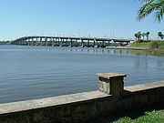
, where the divider begins again on the Granada Bridge
Granada Bridge (Ormond Beach)
The Granada Bridge is a high-clearance bridge that spans the Halifax River and Intracoastal Waterway, linking the mainland and beach peninsula parts of Ormond Beach, Volusia County, Florida. Granada Bridge carries four lanes of Florida State Road 40 and Granada Blvd...
over the Halifax River
Halifax River
The Halifax River is part of the Atlantic Intracoastal Waterway, located in northeast Volusia County, Florida. The waterway was originally known as the North Mosquito River, but was renamed after George Montagu-Dunk, 2nd Earl of Halifax, during the British occupation of Florida .-Geography:The...
, and immediately intersects John Anderson Drive(CR 2803), where one leg of the scenic route heads north and West Granada Boulevard becomes East Granda Boulevard, before finally terminating at Florida State Road A1A
Florida State Road A1A
State Road A1A is a Florida State Road that runs mostly along the Atlantic Ocean, with sections from Key West at the southern tip of Florida, to Callahan, just south of Georgia. It is the main road through most oceanfront towns. SR A1A is designated the A1A Scenic and Historic Coastal Highway, a...
. The other leg of the Ormond Beach Scenic Loop heads north on SR A1A. Despite the fact that SR 40 terminates at SR A1A, East Granada Boulevard continues as a beach access road.
County extensions west of US 41
A western extension of SR 40 continues from US 41 in DunnellonDunnellon, Florida
Dunnellon is a city in Marion County, Florida, United States. The population was 1,898 at the 2000 census. As of 2004, the population recorded by the U.S. Census Bureau is 1,951...
as County Road 40 to the Gulf of Mexico
Gulf of Mexico
The Gulf of Mexico is a partially landlocked ocean basin largely surrounded by the North American continent and the island of Cuba. It is bounded on the northeast, north and northwest by the Gulf Coast of the United States, on the southwest and south by Mexico, and on the southeast by Cuba. In...
through Marion
Marion County, Florida
Marion County is a county located in the U.S. state of Florida. The U.S. Census Bureau 2006 estimate for the county is 316,183. Its county seat is Ocala....
and Levy
Levy County, Florida
Levy County is a county located in the state of Florida. As of 2000, the population was 34,450. The U.S. Census Bureau 2005 estimate for the county is 37,998. Its county seat is Bronson, Florida. Levy is pronounced lee vee.- History :...
Counties north of the Withlacoochee River
Withlacoochee River (South)
The Withlacoochee River originates in central Florida's Green Swamp, east of Polk City. It flows west, then north, and then turns northwest and finally west again before it empties into the Gulf of Mexico near Yankeetown. The river is long and has a drainage basin of...
. Levy County Road 40 is named Follow That Dream Boulevard west of US 19/98 after the 1962 Elvis Presley
Elvis Presley
Elvis Aaron Presley was one of the most popular American singers of the 20th century. A cultural icon, he is widely known by the single name Elvis. He is often referred to as the "King of Rock and Roll" or simply "the King"....
movie that was filmed in Inglis
Inglis, Florida
Inglis is a town located in Levy County, Florida, United States. It is located on U.S. Highway 19 near the Cross Florida Greenway. As of the 2000 census, the town had a total population of 1,491. As of 2004, the population recorded by the U.S...
, Yankeetown
Yankeetown, Florida
Yankeetown is a town in Levy County, Florida, United States. The population was 629 at the 2000 census. According to the U.S. Census Bureau's 2004 estimates, the town had a population of 672.-History:...
and the surrounding area. East of US 19-98, the road is known as Port Avenue in Levy County, and Cedar Street, then Pennsylvania Avenue in Dunnellon. Between Dunnellon and Rainbow Lake Estates, SR 40 serves as a not-so-hidden route along US 41.
Levy County Road 40A
Levy County Road 40A is a suffixed alternate of Levy County Road 40, along Southeast 193rd Place. It begins at the intersection of Levy CR 40 and Allen Park Road and 63rd Street and briefly runs northeast until curving to the east where it runs mostly parallel to the north side of CR 40 into Inglis, where it moves further away from Follow That Dream Boulevard then terminates at US 19U.S. Route 19 in Florida
U.S. Route 19 in Florida runs along Florida's west coast from an interchange with U.S. Route 41 in Memphis, Florida, south of Tampa, and continues to the Georgia border north of Monticello, Florida....
/98
U.S. Route 98 in Florida
U.S. Route 98 is an east-west United States highway that runs from western Mississippi to southern Florida. It was established in 1933 as a route between Pensacola, Florida and Apalachicola, Florida, and has since been extended eastward across the Florida Peninsula and westward into Mississippi...
.
Future
A proposed expansion of SR 40 resulted in the State Road 40 Environmental Feasibility Study, which reviewed potential impact of improvements to the existing highway while not destroying the natural beauty of the area.Major intersections
| County | Location | Mile | Destinations | Notes |
|---|---|---|---|---|
| Marion Marion County, Florida Marion County is a county located in the U.S. state of Florida. The U.S. Census Bureau 2006 estimate for the county is 316,183. Its county seat is Ocala.... |
Rainbow Lake Estates Rainbow Lake Estates, Florida Rainbow Lake Estates is an unincorporated community in Marion County, Florida, United States established as a Municipal Services District. The community is part of the Ocala Metropolitan Statistical Area. This community is northwest of Rainbow Springs a natural spring located in Rainbow Springs... |
0.0 | Western terminus | |
| Ocala Ocala, Florida Ocala is a city in Marion County, Florida. As of 2007, the population recorded by the U.S. Census Bureau was 53,491. It is the county seat of Marion County, and the principal city of the Ocala, Florida Metropolitan Statistical Area, which had an estimated 2007 population of 324,857.-History:Ocala... |
Exit 352 (I-75) | |||
| Silver Springs Silver Springs, Florida Silver Springs is a U.S. populated place and spring in Marion County, Florida, just to the east of the city of Ocala. It is part of the Ocala Metropolitan Statistical Area.... |
||||
| Ocklawaha River Ocklawaha River The Ocklawaha River flows north from central Florida until it joins the St. Johns River near Palatka. Its name is a corruption of ak-lowahe, Creek for "muddy".... |
Bert Dosh Memorial Bridge Bert Dosh Memorial Bridge The Bert Dosh Memorial Bridge carries State Road 40 over the Ocklawaha River in north-central Florida, east of Silver Springs.Originally planned as part of the Cross Florida Barge Canal project, the bridge was under construction at the time of the decision by President Richard Nixon to halt work on... |
|||
| Silver Springs Silver Springs, Florida Silver Springs is a U.S. populated place and spring in Marion County, Florida, just to the east of the city of Ocala. It is part of the Ocala Metropolitan Statistical Area.... |
||||
| Lake Lake County, Florida Lake County is a county located in the state of Florida, United States. As of the 2000 Census, the population was 210,528. The Census Bureau estimated the population in 2008 to be 307,243. Its county seat is Tavares... |
||||
| St. Johns River St. Johns River The St. Johns River is the longest river in the U.S. state of Florida and its most significant for commercial and recreational use. At long, it winds through or borders twelve counties, three of which are the state's largest. The drop in elevation from the headwaters to the mouth is less than ;... |
Astor Bridge | |||
| Volusia Volusia County, Florida Volusia County is a county located in the state of Florida. The U.S. Census Bureau 2010 official county's population was 494,593 . Its county seat is DeLand, and its most populous city is currently Deltona.... |
Barberville Barberville, Florida Barberville is an unincorporated community in Volusia County, Florida, United States. It is located at the intersection of State Road 40 and US 17.-Geography:Barberville is located at .... |
|||
| DeLeon Springs | ||||
| Ormond Beach Ormond Beach, Florida Ormond Beach is a city in Volusia County, Florida, United States. The population was 36,301 at the 2000 census. As of 2004, the population recorded by the U.S. Census Bureau is 37,929. Ormond Beach is the northern neighbor of Daytona Beach and is home to Tomoka State Park.-History:Ormond Beach was... |
Exit 268 (I-95) | |||
| Halifax River Halifax River The Halifax River is part of the Atlantic Intracoastal Waterway, located in northeast Volusia County, Florida. The waterway was originally known as the North Mosquito River, but was renamed after George Montagu-Dunk, 2nd Earl of Halifax, during the British occupation of Florida .-Geography:The... |
Granada Bridge Granada Bridge (Ormond Beach) The Granada Bridge is a high-clearance bridge that spans the Halifax River and Intracoastal Waterway, linking the mainland and beach peninsula parts of Ormond Beach, Volusia County, Florida. Granada Bridge carries four lanes of Florida State Road 40 and Granada Blvd... |
|||
| Ormond Beach Ormond Beach, Florida Ormond Beach is a city in Volusia County, Florida, United States. The population was 36,301 at the 2000 census. As of 2004, the population recorded by the U.S. Census Bureau is 37,929. Ormond Beach is the northern neighbor of Daytona Beach and is home to Tomoka State Park.-History:Ormond Beach was... |
91.7 | Eastern terminus | ||