

State Road 404 (Florida)
Encyclopedia
State Road 404 the Pineda Causeway, is an east–west divided highway currently running from Interstate 95
(I-95) to SR A1A
at Patrick Air Force Base
, Florida
, US. It was opened as a toll road
in 1971 and classified as a state road two years later. The tolls were removed in 1990. It was named after Pineda
, a former village east of Suntree
on U.S. Route 1
(US 1). With interchanges at US 1 (SR 5
), South Tropical Trail (Brevard County Road 3, CR 3), and South Patrick Drive (SR 513
), the Pineda Causeway is (along with SR A1A) the primary access for Patrick Air Force Base and the southern end of Merritt Island
. From US 1 to the eastern terminus, it is part of the Indian River Lagoon Scenic Highway
system.
 From I-95, the Pineda Causeway Extension passes between developments to its north and south. After an intersection with a local road, the route curves to the northeast and later resumes its eastward course, reaching Wickham Road. The route turns to the east and moves across the Florida East Coast Railway
.
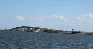
East of the railway, the route crosses below US 1. The eastbound lane has an exit ramp that connects to both directions of US 1; in contrast, the westbound lane has a dedicated exit for both US 1 northbound and a loop to US 1 southbound. The road continues to the east, crossing a small inlet and a small island before ascending over the Indian River
with twin bridges. At the eastern end of the bridges, the route again crosses a small island and inlet before reaching a narrow portion of Merritt Island
. There, the causeway intersects with CR 3. The route crosses a series of islands, forming another twin set of bridges over the Banana River
. After reaching land for the final time, the route enters South Patrick Shores
. It has a partial interchange with SR 513, with only an eastbound exit and a westbound entrance. After passing north of a housing development, the causeway ends at an intersection with SR A1A
.
Along the causeway east of the extension, the Florida Department of Transportation
(FDOT) estimated that 37,500 cars drove on the route each day.
and Patrick Air Force Base
in eastern Brevard County, local politicians in the early 1960s petitioned the United States Bureau of Public Roads for federal funding in creating a new causeway across the Banana River, between the Eau Gallie Causeway
and SR 520. Although the federal agency declined twice due to low traffic projections, local officials maintained the need for the proposed causeway. In November 1969, after FDOT opened bids for various state construction projects, the Gregg, Gibson & Gregg Inc. put out a $7.7 million estimate to build the causeway from US 1 to the eastern shore of the Banana River. Ultimately, the original Pineda Causeway was opened in 1972, costing about $7 million to construct. In the previous year, the route's interchanges with US 1 and CR 3, as well as the bridges, were completed. In 1972, the interchange with SR 513 was finished. On May 31, 1973, FDOT classified the bridge and causeway as State Route 404.
Initially it was a toll road, which funded the road's maintenance. However, FDOT agreed in 1989 to remove the fee and pay for maintenance. In June 1990, workers removed the toll along the Pineda Causeway, along with the Bennett Causeway to the north, at a cost of $745,000. The interchange with U.S. 1, which was first built in 1971, was reconstructed in 1997. In 1999, the route became part of the newly-created Indian River Lagoon Scenic Highway
, which was a series of roads around the Indian River Lagoon.
In conjunction with a project to add additional lanes to I-95, FDOT authorized funding in March 2008 to create an interchange with an extension of the Pineda Causeway. The two projects were estimated to cost $202 million upon completion. On May 2, 2011, the interchange with I-95 opened. FDOT also authorized $10 million to complete the extension from the interchange to its original routing. The overall cost of the extension was estimated at $27 million, of which the remainder not financed by FDOT was paid by impact fee
and gas tax. Groundbreaking for the extension occurred on December 14, 2007, and the project was finished in 2011. This created a 1.9 mi (3.1 km) extension of the highway after decades of planning; once finished, it became a hurricane evacuation route
. The project was expected to aid the local economy due to ease of travel from I-95 to the beach.
In October 2011, five Brevard County commissioners voted to consider the option of purchasing right-of-way and creating an overpass for the causeway over the Florida East Coast Railway line, located just west of US 1. Although there were no immediate plans for such a construction project, the vote allowed for the maintenance of funding, instead of FDOT transferring the money to other projects.
|Melbourne
|0.0
|
|Western terminus; exit 188 (I-95)
|-
|rowspan=2|Palm Shores
|2.3
|
|Traffic signal
|-
|3.0
|
|Interchange
|-
|Merritt Island
|4.4
|
|Interchange
|-
|rowspan=2|South Patrick Shores
|6.4
|
|Partial interchange
|-
|6.9
|
|Eastern terminus
Interstate 95 in Florida
Interstate 95 is the main Interstate Highway on the east coast of the United States; it serves the Atlantic coast of Florida. It begins at a partial interchange with U.S. Highway 1 just south of downtown Miami, and heads north past Daytona Beach and Jacksonville to the Georgia state line at the St...
(I-95) to SR A1A
State Road A1A (Florida)
State Road A1A is a Florida State Road that runs mostly along the Atlantic Ocean, with sections from Key West at the southern tip of Florida, to Callahan, just south of Georgia. It is the main road through most oceanfront towns. SR A1A is designated the A1A Scenic and Historic Coastal Highway, a...
at Patrick Air Force Base
Patrick Air Force Base
Patrick Air Force Base is a United States Air Force Base located between Satellite Beach and Cocoa Beach, in Brevard County, Florida, United States. It was named in honor of Major General Mason Patrick. An Air Force Space Command base, it is home to the 45th Space Wing...
, Florida
Florida
Florida is a state in the southeastern United States, located on the nation's Atlantic and Gulf coasts. It is bordered to the west by the Gulf of Mexico, to the north by Alabama and Georgia and to the east by the Atlantic Ocean. With a population of 18,801,310 as measured by the 2010 census, it...
, US. It was opened as a toll road
Toll road
A toll road is a privately or publicly built road for which a driver pays a toll for use. Structures for which tolls are charged include toll bridges and toll tunnels. Non-toll roads are financed using other sources of revenue, most typically fuel tax or general tax funds...
in 1971 and classified as a state road two years later. The tolls were removed in 1990. It was named after Pineda
Pineda, Florida
Pineda is a former village in Brevard County, Florida, United States The Pineda Causeway, named after this place, carries 4 lanes of State Road 404 south of the former village. It is located at the intersection of Suntree Boulevard and U.S. Route 1 east of Suntree and the Florida East Coast...
, a former village east of Suntree
Suntree, Florida
Suntree is a planned unincorporated community in Brevard County, Florida, United States. It is located near the center of the county, off I-95 near Viera between Interstate 95 and the Florida East Coast Railroad. It lies approximately halfway between Rockledge and Melbourne...
on U.S. Route 1
U.S. Route 1 in Florida
U.S. Route 1 in Florida runs along the state's east coast from Key West to its crossing of the St. Marys River into Georgia north of Boulogne, and south of Folkston. US 1 was designated through Florida when the U.S. Highway System was established in 1926.US 1 runs in the state of Florida, and...
(US 1). With interchanges at US 1 (SR 5
State Road 5 (Florida)
State Road 5 is a mostly-unsigned state highway in the state of Florida. It is mainly signed as U.S. Route 1 from its south end in Key West, Florida to Jacksonville, Florida, and U.S. Route 17 from Jacksonville to the Georgia state line at the Saint Marys River. U.S...
), South Tropical Trail (Brevard County Road 3, CR 3), and South Patrick Drive (SR 513
State Road 513 (Florida)
State Road 513, also known as South Patrick Drive, is a short north–south road providing access to the southern entrance of Patrick Air Force Base near Cocoa Beach, Florida and Satellite Beach, Florida. The northern terminus is at a partial interchange with the Pineda Causeway , a former...
), the Pineda Causeway is (along with SR A1A) the primary access for Patrick Air Force Base and the southern end of Merritt Island
Merritt Island, Florida
Merritt Island is a census-designated place in Brevard County, Florida, United States. It is located on the east coast of the state on the Atlantic Ocean. As of the 2000 census, the population was 36,090. It is part of the Palm Bay – Melbourne – Titusville, Florida Metropolitan Statistical Area...
. From US 1 to the eastern terminus, it is part of the Indian River Lagoon Scenic Highway
Indian River Lagoon Scenic Highway
The Indian River Lagoon Scenic Highway is a long scenic byway located in Florida. Basically, the Highway is actually a collection of several roads, mostly running north and south along either side of the Indian River Lagoon, connected by other roads running over the Lagoon...
system.
Route description
Florida East Coast Railway
The Florida East Coast Railway is a Class II railroad operating in the U.S. state of Florida; in the past, it has been a Class I railroad.Built primarily in the last quarter of the 19th century and the first decade of the 20th century, the FEC was a project of Standard Oil principal Henry Morrison...
.
East of the railway, the route crosses below US 1. The eastbound lane has an exit ramp that connects to both directions of US 1; in contrast, the westbound lane has a dedicated exit for both US 1 northbound and a loop to US 1 southbound. The road continues to the east, crossing a small inlet and a small island before ascending over the Indian River
Indian River (Florida)
The Indian River is a waterway in Florida, a part of the Indian River Lagoon system which forms the Atlantic Intracoastal Waterway. It extends southward from the Ponce de Leon inlet in New Smyrna Beach, Florida [Volusia County] southward and across the "Haulover Canal" and along the western shore...
with twin bridges. At the eastern end of the bridges, the route again crosses a small island and inlet before reaching a narrow portion of Merritt Island
Merritt Island, Florida
Merritt Island is a census-designated place in Brevard County, Florida, United States. It is located on the east coast of the state on the Atlantic Ocean. As of the 2000 census, the population was 36,090. It is part of the Palm Bay – Melbourne – Titusville, Florida Metropolitan Statistical Area...
. There, the causeway intersects with CR 3. The route crosses a series of islands, forming another twin set of bridges over the Banana River
Banana River
The Banana River is a lagoon that lies between Cape Canaveral and Merritt Island in Brevard County, Florida in the United States. It is part of the Indian River Lagoon system, and connects at its south end to the Indian River; it is the only part of the lagoon system not in the Intracoastal...
. After reaching land for the final time, the route enters South Patrick Shores
South Patrick Shores, Florida
South Patrick Shores is a census-designated place in Brevard County, Florida, United States. The population was 8,913 at the 2000 census. It is part of the Palm Bay–Melbourne–Titusville Metropolitan Statistical Area.-Geography:...
. It has a partial interchange with SR 513, with only an eastbound exit and a westbound entrance. After passing north of a housing development, the causeway ends at an intersection with SR A1A
Florida State Road A1A
State Road A1A is a Florida State Road that runs mostly along the Atlantic Ocean, with sections from Key West at the southern tip of Florida, to Callahan, just south of Georgia. It is the main road through most oceanfront towns. SR A1A is designated the A1A Scenic and Historic Coastal Highway, a...
.
Along the causeway east of the extension, the Florida Department of Transportation
Florida Department of Transportation
The Florida Department of Transportation is a decentralized agency charged with the establishment, maintenance, and regulation of public transportation in the state of Florida. The department was formed in 1969. It absorbed the powers of the Florida State Road Department...
(FDOT) estimated that 37,500 cars drove on the route each day.
History
Due to high traffic involving the Kennedy Space CenterKennedy Space Center
The John F. Kennedy Space Center is the NASA installation that has been the launch site for every United States human space flight since 1968. Although such flights are currently on hiatus, KSC continues to manage and operate unmanned rocket launch facilities for America's civilian space program...
and Patrick Air Force Base
Patrick Air Force Base
Patrick Air Force Base is a United States Air Force Base located between Satellite Beach and Cocoa Beach, in Brevard County, Florida, United States. It was named in honor of Major General Mason Patrick. An Air Force Space Command base, it is home to the 45th Space Wing...
in eastern Brevard County, local politicians in the early 1960s petitioned the United States Bureau of Public Roads for federal funding in creating a new causeway across the Banana River, between the Eau Gallie Causeway
Eau Gallie Causeway
The Eau Gallie Causeway connects Eau Gallie, Florida , with SR A1A near Indian Harbour Beach, across the Indian River Lagoon. Located entirely within the Melbourne city limits, the causeway consists of a main bridge crossing over the Intracoastal Waterway and a relief bridge...
and SR 520. Although the federal agency declined twice due to low traffic projections, local officials maintained the need for the proposed causeway. In November 1969, after FDOT opened bids for various state construction projects, the Gregg, Gibson & Gregg Inc. put out a $7.7 million estimate to build the causeway from US 1 to the eastern shore of the Banana River. Ultimately, the original Pineda Causeway was opened in 1972, costing about $7 million to construct. In the previous year, the route's interchanges with US 1 and CR 3, as well as the bridges, were completed. In 1972, the interchange with SR 513 was finished. On May 31, 1973, FDOT classified the bridge and causeway as State Route 404.
Initially it was a toll road, which funded the road's maintenance. However, FDOT agreed in 1989 to remove the fee and pay for maintenance. In June 1990, workers removed the toll along the Pineda Causeway, along with the Bennett Causeway to the north, at a cost of $745,000. The interchange with U.S. 1, which was first built in 1971, was reconstructed in 1997. In 1999, the route became part of the newly-created Indian River Lagoon Scenic Highway
Indian River Lagoon Scenic Highway
The Indian River Lagoon Scenic Highway is a long scenic byway located in Florida. Basically, the Highway is actually a collection of several roads, mostly running north and south along either side of the Indian River Lagoon, connected by other roads running over the Lagoon...
, which was a series of roads around the Indian River Lagoon.
In conjunction with a project to add additional lanes to I-95, FDOT authorized funding in March 2008 to create an interchange with an extension of the Pineda Causeway. The two projects were estimated to cost $202 million upon completion. On May 2, 2011, the interchange with I-95 opened. FDOT also authorized $10 million to complete the extension from the interchange to its original routing. The overall cost of the extension was estimated at $27 million, of which the remainder not financed by FDOT was paid by impact fee
Impact fee
An impact fee is a fee that is implemented by a local government on a new or proposed development to help assist or pay for a portion of the costs that the new development may cause with public services to the new development within the United States...
and gas tax. Groundbreaking for the extension occurred on December 14, 2007, and the project was finished in 2011. This created a 1.9 mi (3.1 km) extension of the highway after decades of planning; once finished, it became a hurricane evacuation route
Hurricane evacuation route
A hurricane evacuation route is a highway in the United States that is a specified route for hurricane evacuation.Along the Gulf Coast, hurricane evacuation routes lead north and west for up to hundreds of miles to the safest major city. Along the Atlantic Coast, routes lead west. They are marked...
. The project was expected to aid the local economy due to ease of travel from I-95 to the beach.
In October 2011, five Brevard County commissioners voted to consider the option of purchasing right-of-way and creating an overpass for the causeway over the Florida East Coast Railway line, located just west of US 1. Although there were no immediate plans for such a construction project, the vote allowed for the maintenance of funding, instead of FDOT transferring the money to other projects.
Major intersections
|-|Melbourne
|0.0
|
|Western terminus; exit 188 (I-95)
|-
|rowspan=2|Palm Shores
Palm Shores, Florida
Palm Shores is a town in Brevard County, Florida, United States. The population was 794 at the 2000 census. As of 2005, the population estimated by the U.S. Census Bureau is 848...
|2.3
|
|Traffic signal
|-
|3.0
|
|Interchange
|-
|Merritt Island
Merritt Island, Florida
Merritt Island is a census-designated place in Brevard County, Florida, United States. It is located on the east coast of the state on the Atlantic Ocean. As of the 2000 census, the population was 36,090. It is part of the Palm Bay – Melbourne – Titusville, Florida Metropolitan Statistical Area...
|4.4
|
|Interchange
|-
|rowspan=2|South Patrick Shores
South Patrick Shores, Florida
South Patrick Shores is a census-designated place in Brevard County, Florida, United States. The population was 8,913 at the 2000 census. It is part of the Palm Bay–Melbourne–Titusville Metropolitan Statistical Area.-Geography:...
|6.4
|
|Partial interchange
|-
|6.9
|
|Eastern terminus