
.gif)
State Highway 51 (Oklahoma)
Encyclopedia
State Highway 51, abbreviated to SH-51 or OK-51, is a major state highway
in Oklahoma
. It runs for 333 miles (535½ km) east–west across the state, running from the Texas
state line to Arkansas
. It is the third-longest state highway in the system.
with US-60 just east of Higgins, Texas
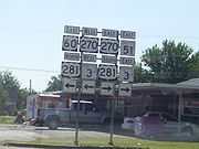
. It remains concurrent for 61 miles (98 km) until it reaches US-270/US-281/SH-3
at Seiling, Oklahoma
. At Seiling, SH-51 joins with those three highways for nine miles (14 km) before splitting off on its own.
11 miles (18 km) after splitting off, Highway 51 meets SH-58 in Canton
. It then continues east, crossing the North Canadian River
and meeting SH-51A before turning
northeast toward Okeene
, where it intersects SH-8
. SH-51 will go for 24 miles (39 km) before intersecting another highway.
 In Hennessey
SH-51 meets U.S. Highway 81 before continuing eastward. 17 miles (27 km) later, it meets SH-74
north of Crescent
. 11 miles (17 km) to the east, it shares a brief concurrency with US-77; two miles (3 km) later it has an interchange at Interstate 35, milemarker 174.
. When Highway 51 reaches Stillwater
, it meets US-177.
Continuing east from Stillwater, the road returns to a two-lane highway after sharing a one-mile (1.6 km) concurrency with SH-108
and intersects with SH-18
eight miles (12.8 km) later. Four miles east of this, it passes through Yale, Oklahoma
before crossing SH-99
. It becomes a multilane highway again after a brief concurrency with SH-48
. It passes through the small towns of Mannford
and Lotsee
on its way toward the Tulsa area.
, SH-51 crosses the Arkansas River
with SH-97
before merging onto the Sand Springs Expressway (U.S. Highway 412/U.S. Highway 64). When this
freeway ends at I-244 near downtown Tulsa
, Highway 51 merges onto I-244 southbound only to exit one mile (1.6 km) later, where it overlaps US-64/US-75. This freeway is actually Interstate 444, but the interstate designation is not shown on signs. After one more mile, SH-51 leaves the interstate with US-64 and becomes the Broken Arrow Expressway, a freeway running northwest-southeast through Tulsa. US-64 leaves the freeway as a concurrency with US-169 southbound. Later, SH-51 will exit the freeway and become a four lane highway toward Coweta. The mainline freeway becomes the Muskogee Turnpike
.
At Coweta
, SH-51 turns back east after heading southeast through the Tulsa area. After crossing the Muskogee Turnpike again and bridging the Verdigris River
the highway soon enters Wagoner
, where it junctions with US-69. Returning once again to a 2-lane road, Highway 51 crosses Ft. Gibson Lake and the town of Hulbert
. 11 miles (17.7 km) later, it passes through Tahlequah
, where it has a brief concurrency with US-62/SH-10
. After spitting with these highways, it heads southeast toward Stilwell, Oklahoma
, overlapping Route 59 for a mile on the way. After leaving Stilwell it provides access to Adair State Park, and then crosses the Arkansas line becoming Highway 244, which quickly connects to Highway 59.
at SH-27 (present-day US-62). By 1928, it had been extended to Tulsa. On June 15, 1933, it was extended to the east to the Arkansas state line, where it became AR-45.
ODOT extended SH-51 west to Stillwater and Perry (via a segment of roadway currently serving as US-177). On March 18, 1935, the section from Stillwater to Perry was rescinded and SH-51 was extended to SH-8 at Okeene. It was then extended to Seiling on October 18, 1938. On March 23, 1943, it was extended to the Texas state line by a concurrency with US-60.
The Broken Arrow Expressway was built in the early 1960s and opened in 1964. It was not, however, officially named the Broken Arrow Expressway until July 6, 1999 by H.B. 1455.
The steel truss bridge carrying SH-51 across Stillwater Creek west of Stillwater, once considered the gateway into the city, was removed on March 25, 2008. In a first for the state of Oklahoma, the bridge, originally built in 1936, was sold to Payne County for $200,000 and transferred to a county road east of Stillwater, where it was installed over Council Creek.
State highway
State highway, state road or state route can refer to one of three related concepts, two of them related to a state or provincial government in a country that is divided into states or provinces :#A...
in Oklahoma
Oklahoma
Oklahoma is a state located in the South Central region of the United States of America. With an estimated 3,751,351 residents as of the 2010 census and a land area of 68,667 square miles , Oklahoma is the 28th most populous and 20th-largest state...
. It runs for 333 miles (535½ km) east–west across the state, running from the Texas
Texas
Texas is the second largest U.S. state by both area and population, and the largest state by area in the contiguous United States.The name, based on the Caddo word "Tejas" meaning "friends" or "allies", was applied by the Spanish to the Caddo themselves and to the region of their settlement in...
state line to Arkansas
Arkansas
Arkansas is a state located in the southern region of the United States. Its name is an Algonquian name of the Quapaw Indians. Arkansas shares borders with six states , and its eastern border is largely defined by the Mississippi River...
. It is the third-longest state highway in the system.
Texas to I-35
SH-51 begins at the Texas line concurrentConcurrency (road)
A concurrency, overlap, or coincidence in a road network is an instance of one physical road bearing two or more different highway, motorway, or other route numbers...
with US-60 just east of Higgins, Texas
Higgins, Texas
Higgins is a city in Lipscomb County, Texas, United States, named after G.H. Higgins, a stockholder in the Santa Fe Railroad. The population was 425 at the 2000 census.-Geography:Higgins is located at ....
. It remains concurrent for 61 miles (98 km) until it reaches US-270/US-281/SH-3
State Highway 3 (Oklahoma)
State Highway 3, also abbreviated as SH-3 or OK-3, is a highway maintained by the U.S. state of Oklahoma. Traveling diagonally through Oklahoma, from the Panhandle to the far southeastern corner of the state, SH-3 is the longest state highway in the Oklahoma road system, at a total length of...
at Seiling, Oklahoma
Seiling, Oklahoma
Seiling is a city in Dewey County, Oklahoma, United States. The population was 860 at the 2010 census.-Geography:Seiling is located at .According to the United States Census Bureau, the city has a total area of , all of it land....
. At Seiling, SH-51 joins with those three highways for nine miles (14 km) before splitting off on its own.
11 miles (18 km) after splitting off, Highway 51 meets SH-58 in Canton
Canton, Oklahoma
Canton is a town in Blaine County, Oklahoma, United States. The population was 625 at the 2010 census.-Geography:Canton is located at .According to the United States Census Bureau, the town has a total area of , all of it land....
. It then continues east, crossing the North Canadian River
North Canadian River
The North Canadian River is a tributary of the Canadian River, approximately long, that flows through New Mexico, Texas and Oklahoma in the United States....
and meeting SH-51A before turning
northeast toward Okeene
Okeene, Oklahoma
Okeene is a town in Blaine County, Oklahoma, United States. The population was 1,240 at the 2000 census.-Geography:Okeene is located at .According to the United States Census Bureau, the town has a total area of , all of it land....
, where it intersects SH-8
State Highway 8 (Oklahoma)
State Highway 8, also abbreviated as SH-8 or OK-8, is a highway maintained by the U.S. state of Oklahoma. Because it runs mainly north–south, it has an even number . Highway 8 runs from U.S...
. SH-51 will go for 24 miles (39 km) before intersecting another highway.
Hennessey, Oklahoma
Hennessey is a town in Kingfisher County, Oklahoma, United States. The population was 2,058 at the 2000 census.-History:Hennessey is named after Pat Hennessy, an Irish freighter who was killed at the present townsite in April, 1874...
SH-51 meets U.S. Highway 81 before continuing eastward. 17 miles (27 km) later, it meets SH-74
State Highway 74 (Oklahoma)
State Highway 74, usually abbreviated as SH-74 or OK-74 is the numbering of two different highways maintained by the U.S. state of Oklahoma. These highways were once a single major north–south route, connecting Oklahoma City to more rural parts of the state...
north of Crescent
Crescent, Oklahoma
Crescent is a city in Logan County, Oklahoma, United States. The population inside the city limits was 1,281 at the 2000 census. It is part of the Oklahoma City Metropolitan Statistical Area...
. 11 miles (17 km) to the east, it shares a brief concurrency with US-77; two miles (3 km) later it has an interchange at Interstate 35, milemarker 174.
I-35 to Tulsa
After crossing I-35, SH-51 becomes a multilane highway and a major corridor linking I-35 to Stillwater, the home of Oklahoma State University. Along this 13 miles (20.9 km) stretch is an intersection with State Highway 86State Highway 86 (Oklahoma)
State Highway 86 is a minor state highway that connects SH-51 with Perry. The highway is contained wholly in Payne and Noble Counties.-Route description:...
. When Highway 51 reaches Stillwater
Stillwater, Oklahoma
Stillwater is a city in north-central Oklahoma at the intersection of U.S. 177 and State Highway 51. It is the county seat of Payne County, Oklahoma, United States. As of the 2010 census, the city population was 45,688. Stillwater is the principal city of the Stillwater Micropolitan Statistical...
, it meets US-177.
Continuing east from Stillwater, the road returns to a two-lane highway after sharing a one-mile (1.6 km) concurrency with SH-108
State Highway 108 (Oklahoma)
State Highway 108 is a minor state highway in Payne, Noble, and Pawnee Counties, in North Central Oklahoma. It runs for approximately . SH-108 has no lettered spurs.SH-108 was added to the state highway system on July 11, 1955...
and intersects with SH-18
State Highway 18 (Oklahoma)
State Highway 18, abbreviated as SH-18 or OK-18, is a highway maintained by the U.S. state of Oklahoma. It was once one of the longest state highways in the Oklahoma road system, but now has a total length of .-Route description:...
eight miles (12.8 km) later. Four miles east of this, it passes through Yale, Oklahoma
Yale, Oklahoma
Yale is a city in Payne County, Oklahoma, United States. The population was 1,342 at the 2000 census.-Geography:Yale is located at . According to the United States Census Bureau, the city has a total area of , all land....
before crossing SH-99
State Highway 99 (Oklahoma)
State Highway 99, also referred to as SH-99 or OK-99, is a north–south state highway through central Oklahoma. It runs from the Texas border at Lake Texoma to the Kansas border near Lake Hulah. It is long. The highway overlaps US-377 for over half its length.SH-99 links up with K-99 after...
. It becomes a multilane highway again after a brief concurrency with SH-48
State Highway 48 (Oklahoma)
State Highway 48 is a state highway in eastern Oklahoma that runs nearly from Bryan County to Pawnee County. SH-48 has one lettered spur in Johnston County.-Route description:...
. It passes through the small towns of Mannford
Mannford, Oklahoma
Mannford is a town in Creek, Pawnee, and Tulsa counties in the northeastern part of the U.S. state of Oklahoma. In 2010, the population was 3,076 compared to 2,095 at the 2000 census. A bedroom community of Tulsa sitting on Lake Keystone, this town claims to be, "the Striped Bass Capital of the...
and Lotsee
Lotsee, Oklahoma
Lotsee is a town in Tulsa County, Oklahoma, United States. The population was two at the 2010 Census, compared to 11 in the 2000 census. The entire town is a family-owned cattle and pecan ranch, the Flying G Ranch, whose owner, George Campbell, incorporated it in 1963...
on its way toward the Tulsa area.
Tulsa and beyond
In Sand SpringsSand Springs, Oklahoma
Sand Springs is a city in Osage and Tulsa counties in the U.S. state of Oklahoma. A suburb of Tulsa, it is located predominantly in Tulsa County. The population was 18,906 in the 2010 U. S. Census, compared to 17,451 at the 2000 census. The city was founded in 1911, by Oklahoma philanthropist...
, SH-51 crosses the Arkansas River
Arkansas River
The Arkansas River is a major tributary of the Mississippi River. The Arkansas generally flows to the east and southeast as it traverses the U.S. states of Colorado, Kansas, Oklahoma, and Arkansas. The river's initial basin starts in the Western United States in Colorado, specifically the Arkansas...
with SH-97
State Highway 97 (Oklahoma)
State Highway 97, sometimes abbreviated to SH-97 or OK-97, is a state highway, maintained by the U.S. state of Oklahoma. It connects two towns in the northeast part of the state: Sapulpa and Sand Springs. Several communities of West Tulsa are along the road between these two towns, including...
before merging onto the Sand Springs Expressway (U.S. Highway 412/U.S. Highway 64). When this
freeway ends at I-244 near downtown Tulsa
Tulsa, Oklahoma
Tulsa is the second-largest city in the state of Oklahoma and 46th-largest city in the United States. With a population of 391,906 as of the 2010 census, it is the principal municipality of the Tulsa Metropolitan Area, a region with 937,478 residents in the MSA and 988,454 in the CSA. Tulsa's...
, Highway 51 merges onto I-244 southbound only to exit one mile (1.6 km) later, where it overlaps US-64/US-75. This freeway is actually Interstate 444, but the interstate designation is not shown on signs. After one more mile, SH-51 leaves the interstate with US-64 and becomes the Broken Arrow Expressway, a freeway running northwest-southeast through Tulsa. US-64 leaves the freeway as a concurrency with US-169 southbound. Later, SH-51 will exit the freeway and become a four lane highway toward Coweta. The mainline freeway becomes the Muskogee Turnpike
Muskogee Turnpike
-Route description:Opened in 1969, the 53-mile route begins at the Broken Arrow Expressway southeast of Tulsa, near an intersection with the Creek Turnpike. The Turnpike ends at Interstate 40 west of Webbers Falls. There are two toll collection plazas located along the length of the Muskogee...
.
At Coweta
Coweta, Oklahoma
Coweta is a city in Wagoner County, Oklahoma, United States and is a suburb of Tulsa. As of 2010, the population was 9,943.-History:Before statehood, when the Five Tribes or Five Civilized Tribes were moved to Oklahoma from the Eastern United States, the area that is now Coweta became part of the...
, SH-51 turns back east after heading southeast through the Tulsa area. After crossing the Muskogee Turnpike again and bridging the Verdigris River
Verdigris River
The Verdigris River is a tributary of the Arkansas River in southeastern Kansas and northeastern Oklahoma in the United States. It is about long...
the highway soon enters Wagoner
Wagoner, Oklahoma
Wagoner is a city in Wagoner County, Oklahoma, United States. The population was 7,669 at the 2000 census. It is the county seat of Wagoner County.-Geography:Wagoner is located at ....
, where it junctions with US-69. Returning once again to a 2-lane road, Highway 51 crosses Ft. Gibson Lake and the town of Hulbert
Hulbert, Oklahoma
Hulbert is a town in Cherokee County, Oklahoma, United States, named after Ben H. Hulbert, a promiment Cherokee Indian. The population was 543 at the 2000 census. Our Lady of the Annunciation of Clear Creek Monastery is a Benedictine Monastery located in Hulbert...
. 11 miles (17.7 km) later, it passes through Tahlequah
Tahlequah, Oklahoma
Tahlequah is a city in Cherokee County, Oklahoma, United States located at the foothills of the Ozark Mountains. It was founded as a capital of the original Cherokee Nation in 1838 to welcome those Cherokee forced west on the Trail of Tears. The city's population was 15,753 at the 2010 census. It...
, where it has a brief concurrency with US-62/SH-10
State Highway 10 (Oklahoma)
State Highway 10 is a state highway in northeastern Oklahoma. It makes a 235.5 mile crescent through the northeast corner of the state, running from State Highway 99 in Osage County to Interstate 40 near Gore. It has two lettered spur routes.SH-10 first appeared as part of the original highway...
. After spitting with these highways, it heads southeast toward Stilwell, Oklahoma
Stilwell, Oklahoma
Stilwell is a town in Adair County, Oklahoma, United States. The population was 3,276 at the 2000 census. It is the county seat of Adair County...
, overlapping Route 59 for a mile on the way. After leaving Stilwell it provides access to Adair State Park, and then crosses the Arkansas line becoming Highway 244, which quickly connects to Highway 59.
History
SH-51 was originally commissioned on June 1, 1927 as a connector from Stilwell to EldonEldon, Oklahoma
Eldon is a census-designated place in Cherokee County, Oklahoma, United States. The population was 991 at the 2000 census. It lies east of Tahlequah at the junction of U.S. Highway 62 and State Highway 51. The Eldon Post Office existed from March 20, 1911, until May 30, 1936...
at SH-27 (present-day US-62). By 1928, it had been extended to Tulsa. On June 15, 1933, it was extended to the east to the Arkansas state line, where it became AR-45.
ODOT extended SH-51 west to Stillwater and Perry (via a segment of roadway currently serving as US-177). On March 18, 1935, the section from Stillwater to Perry was rescinded and SH-51 was extended to SH-8 at Okeene. It was then extended to Seiling on October 18, 1938. On March 23, 1943, it was extended to the Texas state line by a concurrency with US-60.
The Broken Arrow Expressway was built in the early 1960s and opened in 1964. It was not, however, officially named the Broken Arrow Expressway until July 6, 1999 by H.B. 1455.
The steel truss bridge carrying SH-51 across Stillwater Creek west of Stillwater, once considered the gateway into the city, was removed on March 25, 2008. In a first for the state of Oklahoma, the bridge, originally built in 1936, was sold to Payne County for $200,000 and transferred to a county road east of Stillwater, where it was installed over Council Creek.
Spurs
Like many in the Oklahoma state highway system, SH-51 has short spurs branching from it that bear the "51" number with a lettered suffix:- SH-51A (23 mi/37 km) runs from SH-58 northeast of Canton to SH-8 near Roman Nose State Park. It is the longest suffixed highway in the system http://www.okhighways.com/ok51a.html.
- SH-51B (18½ mi/30 km) connects Coweta to US-69 north of MuskogeeMuskogee, OklahomaMuskogee is a city in Muskogee County, Oklahoma, United States. It is the county seat of Muskogee County, and home to Bacone College. The population was 38,310 at the 2000 census, making it the eleventh-largest city in Oklahoma....
. It goes through the towns of PorterPorter, OklahomaPorter is a town in Wagoner County, Oklahoma, United States. The population was 574 at the 2000 census.-Geography:Porter is located at .According to the United States Census Bureau, the town has a total area of , all of it land....
and TullahasseeTullahassee, OklahomaTullahassee is a town in Wagoner County, Oklahoma, United States. The population was 106 at the 2000 census.-Geography:Tullahassee is located at ....
. - SH-51C (decommissioned) (1.7 mi/2.7 km) connected SH-51 west of Stillwater to Carl Blackwell Lake until it was decommissioned in 2005.
- SH-51D (decommissioned) connected SH-51 south of Sand SpringsSand Springs, OklahomaSand Springs is a city in Osage and Tulsa counties in the U.S. state of Oklahoma. A suburb of Tulsa, it is located predominantly in Tulsa County. The population was 18,906 in the 2010 U. S. Census, compared to 17,451 at the 2000 census. The city was founded in 1911, by Oklahoma philanthropist...
with I-244 in TulsaTulsa, OklahomaTulsa is the second-largest city in the state of Oklahoma and 46th-largest city in the United States. With a population of 391,906 as of the 2010 census, it is the principal municipality of the Tulsa Metropolitan Area, a region with 937,478 residents in the MSA and 988,454 in the CSA. Tulsa's...
, running along Avery Drive and W. 21st Street. It appeared on some ODOTOklahoma Department of TransportationThe Oklahoma Department of Transportation is an agency of the government of Oklahoma responsible for the construction, maintenance, and regulation the use of the state's transportation infrastructure...
maps as late as the 1970s, but is no longer shown. - In 2004, ODOT completed SH-51 Spur, running for 3 miles (4.8 km) through Tahlequah to end at State Highway 82. It is currently the newest Oklahoma state highway. http://okhighways.com/ok51spur