
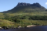
Stac Pollaidh
Encyclopedia
Mountain
Image:Himalaya_annotated.jpg|thumb|right|The Himalayan mountain range with Mount Everestrect 58 14 160 49 Chomo Lonzorect 200 28 335 52 Makalurect 378 24 566 45 Mount Everestrect 188 581 920 656 Tibetan Plateaurect 250 406 340 427 Rong River...
in the Northwest Highlands
Northwest Highlands
The Northwest Highlands are the northern third of Scotland that is separated from the Grampian Mountains by the Great Glen . The region comprises , Assynt, Caithness and Sutherland. The Caledonian Canal, which extends from Loch Linnhe in the west, via Loch Ness to the Moray Firth in the north...
of Scotland
Scotland
Scotland is a country that is part of the United Kingdom. Occupying the northern third of the island of Great Britain, it shares a border with England to the south and is bounded by the North Sea to the east, the Atlantic Ocean to the north and west, and the North Channel and Irish Sea to the...
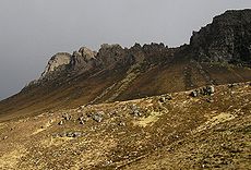
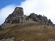
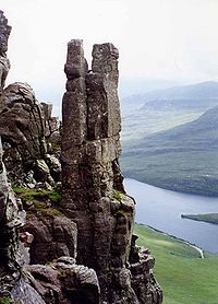
. The peak displays a rocky crest of Torridonian sandstone, with many pinnacles and steep gullies
Gully
A gully is a landform created by running water, eroding sharply into soil, typically on a hillside. Gullies resemble large ditches or small valleys, but are metres to tens of metres in depth and width...
. The crest is extremely weathered
Weathering
Weathering is the breaking down of rocks, soils and minerals as well as artificial materials through contact with the Earth's atmosphere, biota and waters...
(more so than other Torridonian peaks), suggesting that it was not covered in ice during the last Ice Age
Ice age
An ice age or, more precisely, glacial age, is a generic geological period of long-term reduction in the temperature of the Earth's surface and atmosphere, resulting in the presence or expansion of continental ice sheets, polar ice sheets and alpine glaciers...
.
The name Stac Pollaidh is often anglicised
Anglicisation
Anglicisation, or anglicization , is the process of converting verbal or written elements of any other language into a form that is more comprehensible to an English speaker, or, more generally, of altering something such that it becomes English in form or character.The term most often refers to...
to Stack Polly. Due to its relatively low height of just over 2000 feet, fine views and ease of access from a road it has become a very popular peak to climb. It also provides some fine scrambling
Scrambling
Scrambling is a method of ascending rocky faces and ridges. It is an ambiguous term that lies somewhere between hillwalking and rock climbing. It is often distinguished from hillwalking by defining a scramble as a route where hands must be used in the ascent...
in the traverse of the summit ridge, including one bad step near the final summit. Consequentially it has suffered from a great deal of erosion
Erosion
Erosion is when materials are removed from the surface and changed into something else. It only works by hydraulic actions and transport of solids in the natural environment, and leads to the deposition of these materials elsewhere...
, leading to Scottish Natural Heritage
Scottish Natural Heritage
Scottish Natural Heritage is a Scottish public body. It is responsible for Scotland's natural heritage, especially its natural, genetic and scenic diversity. It advises the Scottish Government and acts as a government agent in the delivery of conservation designations, i.e...
constructing a large path
Trail
A trail is a path with a rough beaten or dirt/stone surface used for travel. Trails may be for use only by walkers and in some places are the main access route to remote settlements...
.
Ascent
Hour
The hour is a unit of measurement of time. In modern usage, an hour comprises 60 minutes, or 3,600 seconds...
s by any relatively fit person. From the car park on the shore of Loch Lurgainn the path leads directly up, under the spires of the crest. About 200 m from the road the path splits; one may choose either since both meet up on the far side of the hill, from where it is only a short distance to the summit ridge.
Sandstone
Sandstone is a sedimentary rock composed mainly of sand-sized minerals or rock grains.Most sandstone is composed of quartz and/or feldspar because these are the most common minerals in the Earth's crust. Like sand, sandstone may be any colour, but the most common colours are tan, brown, yellow,...
pinnacles are impressive and are rated in Scotland as second only to the ones on Quiraing
Quiraing
The Quiraing is a landslip on the eastern face of Meall na Suiramach, the northernmost summit of the Trotternish Ridge on the Isle of Skye. The whole of the Trotternish Ridge escarpment was formed by a great series of landslips; the Quiraing is the only part of the slip still moving, the road at...
on the Isle of Skye. They carry names such as "The Sphinx", "Tam o' Shanter", "Andy Capp" and "Madonna and Child", a particularly fine example known as the "Lobsters Claw" partly collapsed several years ago due to natural erosion. The lower, eastern, peak can be reached without any difficulty. From any point on the crest there are excellent views of the wide expanse of the Inverpolly Forest, and of neighbouring peaks such as Suilven
Suilven
Suilven is one of the most distinctive mountains in Scotland. Lying in a remote area in the west of Sutherland, it rises almost vertically from a wilderness landscape of moorland, bogs and lochans known as Inverpolly National Nature Reserve....
. The views of the Atlantic are breathtaking. Returning via the other path allows for a circular walk of about 3 km.