
St Neots
Encyclopedia
St Neots s is a town and civil parish with a population of 26,356 people. It lies on the River Great Ouse
in Huntingdonshire District
, approximately 49 miles (78.9 km) north of central London
, and is the largest town in Cambridgeshire
(Cambridge
and Peterborough
both being cities). The town is named after the Cornish
monk St. Neot
whose bones were stolen from the village of St Neot on Bodmin Moor
and concealed in the nearby priory
of the same name.
The pilgrim trade brought prosperity for the town, and it was granted a market charter in 1130. In the 18th and 19th centuries, the town enjoyed further prosperity through corn milling, brewing, stagecoach
ing and railways.
In 1973, St Neots was one of the towns listed in Hansard
as being designated for expansion to allow for London overspill
.
and Eaton Socon
, which were originally separate villages. Already the largest town in Cambridgeshire, after the cities of Cambridge and Peterborough, St Neots continues to grow rapidly due to a huge demand for modern housing.
Technology-based industries now operate from some of the town's light industrial estates, and there is a gas turbine
power station
at Little Barford
on the edge of the town.
Recent development has added Eynesbury Manor and the Island, Little Paxton
bringing the population above 30,000. Around 1,250 new homes are in course of construction at Love's Farm Estate, to the east
of the town.
district and is situated in the valley of the River Great Ouse
, partly on the flood plain and partly on slightly higher ground a little further from the water. The Great Ouse is a mature river, once wide and shallow but now controlled by weir
s and sluice
s and restrained in a well-defined channel.
Tributaries
entering the Great Ouse in the town are the River Kym
, Hen Brook, Duloe Brook and Colmworth Brook. The area is generally low lying and the Riverside Fields, an amenity area adjacent to St Neots Bridge, is designed as a flood buffer area, and is under water at times of flood, protecting dwelling and commercial property from flood.
St Neots developed at the site of a ford where overland routes converged. This was replaced by a medieval bridge, and today there are two further crossings just outside the town, one to the north and another to the south.
The soil is mainly light, overlying gravel
beds, and gravel extraction is one of the local industries. Older disused gravel pit
s form useful nature reserves and amenity areas at nearby Paxton Pits
and at the Wyboston Leisure Park
. Away from the river, the higher land is mainly a heavy clay
soil with few large settlements. Much of the land is used for arable
farming.
St Neots is close to Cambridge
and Bedford, and is within an hours drive of central London.
 St Neots is bypassed by the A1 which links the town by road with London
to the South and Peterborough to the North, while the nearby A14 provides access to the Midlands
and East Anglia
.
Until the three-mile £8m A45 St Neots Bypass opened in December 1985 (subsequently re-designated as the A428
), traffic to and from Cambridge had to pass through the town centre.
The A421
begins at Black Cat Roundabout
on the A1 just South of the town, connecting with Bedford and Milton Keynes, and carrying much of the traffic between Oxford and Cambridge.
from Peterborough via St Neots to London, taking 40 minutes to King's Cross.
Regular local bus services are provided by Stagecoach in Huntingdonshire and Go Whippet. St Neots is served by the cross country X5
service that runs between Cambridge and Oxford
.
There are also infrequent buses to Cambourne
, Huntingdon and a range of local villages.
and London Stansted Airport
national cycle route that connects Colchester
and Oxford
via Harwich
, Felixstowe
, Ipswich
, Bury St. Edmunds
, Cambridge, Huntingdon
, Sandy
, Bedford
and Milton Keynes
.
Connect2
project. The bridge has an estimated cost of £3.5 Million with Sustrans contributing an additional £600,000. The earliest construction start date is for autumn 2009, with an open date of summer 2010. The use of a Compulsory Purchase Order
for the necessary land has been approved if required and if used this could delay the project by one year. The route of the cycle way is intended to connect Shakespeare Road, in Eaton Socon, to Barford Road, in Eynesbury and follow the southern boundary of St.Neots Community School.
and even pre-Roman finds have been made in and around St Neots, there was no significant settlement until Saxon
times. Early developments were in Eynesbury
, Eaton Socon
and Eaton Ford
, which still exist as part of the town today; and Maltman's Green and Crosshall Ford which are no longer recognised.
The Normans
rebuilt the Priory
near the river and the town of St Neots grew up against its southern wall.
. The old water-powered mill was developed by Bloor Homes recently as an "executive" estate but the new development will be a mixture of properties including council house
s.
Some residents have criticised the new developments as they are technically outside the town's boundaries, meaning that while they will use and depend on the town's infrastructure, the new residents' council tax will not contribute towards St Neots' coffers. The town's boundaries were re-drawn to include Love's Farm and Eynesbury Manor in April 2010.
River Great Ouse
The Great Ouse is a river in the east of England. At long, it is the fourth-longest river in the United Kingdom. The river has been important for navigation, and for draining the low-lying region through which it flows. Its course has been modified several times, with the first recorded being in...
in Huntingdonshire District
Huntingdonshire
Huntingdonshire is a local government district of Cambridgeshire, covering the area around Huntingdon. Traditionally it is a county in its own right...
, approximately 49 miles (78.9 km) north of central London
London
London is the capital city of :England and the :United Kingdom, the largest metropolitan area in the United Kingdom, and the largest urban zone in the European Union by most measures. Located on the River Thames, London has been a major settlement for two millennia, its history going back to its...
, and is the largest town in Cambridgeshire
Cambridgeshire
Cambridgeshire is a county in England, bordering Lincolnshire to the north, Norfolk to the northeast, Suffolk to the east, Essex and Hertfordshire to the south, and Bedfordshire and Northamptonshire to the west...
(Cambridge
Cambridge
The city of Cambridge is a university town and the administrative centre of the county of Cambridgeshire, England. It lies in East Anglia about north of London. Cambridge is at the heart of the high-technology centre known as Silicon Fen – a play on Silicon Valley and the fens surrounding the...
and Peterborough
Peterborough
Peterborough is a cathedral city and unitary authority area in the East of England, with an estimated population of in June 2007. For ceremonial purposes it is in the county of Cambridgeshire. Situated north of London, the city stands on the River Nene which flows into the North Sea...
both being cities). The town is named after the Cornish
Cornwall
Cornwall is a unitary authority and ceremonial county of England, within the United Kingdom. It is bordered to the north and west by the Celtic Sea, to the south by the English Channel, and to the east by the county of Devon, over the River Tamar. Cornwall has a population of , and covers an area of...
monk St. Neot
Saint Neot
Neot is a saint of the 9th century who lived as a monk in Cornwall. He is mentioned in an interpolated passage in Asser's Life of King Alfred and died around AD 870....
whose bones were stolen from the village of St Neot on Bodmin Moor
Bodmin Moor
Bodmin Moor is a granite moorland in northeastern Cornwall, England, United Kingdom. It is in size, and originally dates from the Carboniferous period of geological history....
and concealed in the nearby priory
St Neots Priory
St Neots Priory was a Benedictine monastery in what is now the town of St Neots in the English county of Cambridgeshire within the district of Huntingdonshire.-Anglo-Saxon monastery:...
of the same name.
The pilgrim trade brought prosperity for the town, and it was granted a market charter in 1130. In the 18th and 19th centuries, the town enjoyed further prosperity through corn milling, brewing, stagecoach
Stagecoach
A stagecoach is a type of covered wagon for passengers and goods, strongly sprung and drawn by four horses, usually four-in-hand. Widely used before the introduction of railway transport, it made regular trips between stages or stations, which were places of rest provided for stagecoach travelers...
ing and railways.
In 1973, St Neots was one of the towns listed in Hansard
Hansard
Hansard is the name of the printed transcripts of parliamentary debates in the Westminster system of government. It is named after Thomas Curson Hansard, an early printer and publisher of these transcripts.-Origins:...
as being designated for expansion to allow for London overspill
London overspill
London overspill is the term given to the communities created - largely consisting of publicly provided housing - as a result of the Government policy of moving residents out of Greater London, England into other towns around the South East, East Anglia and beyond.-Policy development:The policy...
.
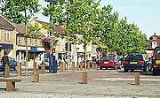
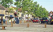
Today
Today, St Neots is a thriving dormitory, commuter and market town. The modern town incorporates Eynesbury (originally the main settlement and the oldest part of the town) and two areas across the river, Eaton FordEaton Ford
Eaton Ford is a district of St Neots and is in Cambridgeshire, England. Until 1965 it was a separate village in the county of Bedfordshire, when it was absorbed through boundary changes. Eaton Ford lies on the west bank of the River Great Ouse, on the western side of St Neots...
and Eaton Socon
Eaton Socon
Eaton Socon is a district of St Neots in Cambridgeshire, England. It was originally a village in Bedfordshire, along with the neighbouring village of Eaton Ford, but officially became part of the town in 1965...
, which were originally separate villages. Already the largest town in Cambridgeshire, after the cities of Cambridge and Peterborough, St Neots continues to grow rapidly due to a huge demand for modern housing.
Technology-based industries now operate from some of the town's light industrial estates, and there is a gas turbine
Gas turbine
A gas turbine, also called a combustion turbine, is a type of internal combustion engine. It has an upstream rotating compressor coupled to a downstream turbine, and a combustion chamber in-between....
power station
Power station
A power station is an industrial facility for the generation of electric energy....
at Little Barford
Little Barford
Little Barford is a village and civil parish located in Bedfordshire, England. It lies on the county boundary with Cambridgeshire, adjacent to the town of St Neots...
on the edge of the town.
Recent development has added Eynesbury Manor and the Island, Little Paxton
Little Paxton
Shittle Paxton in Cambridgeshire, England is a village near Great Paxton north of St Neots. It is in the district and historic county of Huntingdonshire. Until the 1970s it was a minor village and the church was under threat of closure...
bringing the population above 30,000. Around 1,250 new homes are in course of construction at Love's Farm Estate, to the east
East
East is a noun, adjective, or adverb indicating direction or geography.East is one of the four cardinal directions or compass points. It is the opposite of west and is perpendicular to north and south.By convention, the right side of a map is east....
of the town.
Local geography
St Neots lies close to the south-western edge of HuntingdonshireHuntingdonshire
Huntingdonshire is a local government district of Cambridgeshire, covering the area around Huntingdon. Traditionally it is a county in its own right...
district and is situated in the valley of the River Great Ouse
River Great Ouse
The Great Ouse is a river in the east of England. At long, it is the fourth-longest river in the United Kingdom. The river has been important for navigation, and for draining the low-lying region through which it flows. Its course has been modified several times, with the first recorded being in...
, partly on the flood plain and partly on slightly higher ground a little further from the water. The Great Ouse is a mature river, once wide and shallow but now controlled by weir
Weir
A weir is a small overflow dam used to alter the flow characteristics of a river or stream. In most cases weirs take the form of a barrier across the river that causes water to pool behind the structure , but allows water to flow over the top...
s and sluice
Sluice
A sluice is a water channel that is controlled at its head by a gate . For example, a millrace is a sluice that channels water toward a water mill...
s and restrained in a well-defined channel.
Tributaries
Tributary
A tributary or affluent is a stream or river that flows into a main stem river or a lake. A tributary does not flow directly into a sea or ocean...
entering the Great Ouse in the town are the River Kym
River Kym
The River Kym is a river in Cambridgeshire, England. It flows through the village of Tilbrook, to Kimbolton, and joins the Great Ouse at St Neots....
, Hen Brook, Duloe Brook and Colmworth Brook. The area is generally low lying and the Riverside Fields, an amenity area adjacent to St Neots Bridge, is designed as a flood buffer area, and is under water at times of flood, protecting dwelling and commercial property from flood.
St Neots developed at the site of a ford where overland routes converged. This was replaced by a medieval bridge, and today there are two further crossings just outside the town, one to the north and another to the south.
The soil is mainly light, overlying gravel
Gravel
Gravel is composed of unconsolidated rock fragments that have a general particle size range and include size classes from granule- to boulder-sized fragments. Gravel can be sub-categorized into granule and cobble...
beds, and gravel extraction is one of the local industries. Older disused gravel pit
Gravel pit
Gravel pit is the term for an open cast working for extraction of gravel. Gravel pits often lie in river valleys where the water table is high, so they may fill naturally with water to form ponds or lakes. Old, abandoned gravel pits are normally used either as nature reserves, or as amenity areas...
s form useful nature reserves and amenity areas at nearby Paxton Pits
Paxton Pits Nature Reserve
Paxton Pits is an area of active and disused gravel pits at Little Paxton near St Neots in Cambridgeshire, England. The disused pits have been made into a nature reserve, especially for waterfowl but also for other birds, animals and plants.-External links:*...
and at the Wyboston Leisure Park
Wyboston
Wyboston is a village in the English county of Bedfordshire.The eastern part of the village is dominated by the A1 Great North Road which at this point also carries the traffic of the A428 east–west road. The northern junction of these roads is grade-separated, while the southern junction is a...
. Away from the river, the higher land is mainly a heavy clay
Clay
Clay is a general term including many combinations of one or more clay minerals with traces of metal oxides and organic matter. Geologic clay deposits are mostly composed of phyllosilicate minerals containing variable amounts of water trapped in the mineral structure.- Formation :Clay minerals...
soil with few large settlements. Much of the land is used for arable
Arable land
In geography and agriculture, arable land is land that can be used for growing crops. It includes all land under temporary crops , temporary meadows for mowing or pasture, land under market and kitchen gardens and land temporarily fallow...
farming.
St Neots is close to Cambridge
Cambridge
The city of Cambridge is a university town and the administrative centre of the county of Cambridgeshire, England. It lies in East Anglia about north of London. Cambridge is at the heart of the high-technology centre known as Silicon Fen – a play on Silicon Valley and the fens surrounding the...
and Bedford, and is within an hours drive of central London.
Road
London
London is the capital city of :England and the :United Kingdom, the largest metropolitan area in the United Kingdom, and the largest urban zone in the European Union by most measures. Located on the River Thames, London has been a major settlement for two millennia, its history going back to its...
to the South and Peterborough to the North, while the nearby A14 provides access to the Midlands
English Midlands
The Midlands, or the English Midlands, is the traditional name for the area comprising central England that broadly corresponds to the early medieval Kingdom of Mercia. It borders Southern England, Northern England, East Anglia and Wales. Its largest city is Birmingham, and it was an important...
and East Anglia
East Anglia
East Anglia is a traditional name for a region of eastern England, named after an ancient Anglo-Saxon kingdom, the Kingdom of the East Angles. The Angles took their name from their homeland Angeln, in northern Germany. East Anglia initially consisted of Norfolk and Suffolk, but upon the marriage of...
.
Until the three-mile £8m A45 St Neots Bypass opened in December 1985 (subsequently re-designated as the A428
A428 road
The A428 road is a major road in central and eastern England. It connects the cities of Coventry and Cambridge by way of the county towns of Northampton and Bedford.-Coventry - Northampton:...
), traffic to and from Cambridge had to pass through the town centre.
The A421
A421 road
The A421 is an important road for east/west journeys across England. Together with the A428, the A43 and A34, it forms the route from Cambridge through Milton Keynes to Oxford...
begins at Black Cat Roundabout
Black Cat Roundabout
Black Cat Roundabout is the name of the roundabout on the junction between the A1 and A421 Bedford road just south of St Neots...
on the A1 just South of the town, connecting with Bedford and Milton Keynes, and carrying much of the traffic between Oxford and Cambridge.
Public transport
There is a rail serviceSt Neots railway station
St Neots Railway Station serves the town of St Neots in Cambridgeshire, England. It is located to the north-east of the town approximately 1.5 miles from the town centre. The station is approximately north of London Kings Cross on the East Coast Main Line. St...
from Peterborough via St Neots to London, taking 40 minutes to King's Cross.
Regular local bus services are provided by Stagecoach in Huntingdonshire and Go Whippet. St Neots is served by the cross country X5
Stagecoach bus route X5
Stagecoach bus route X5 is an inter-urban bus service linking Oxford and Cambridge via Bicester, Buckingham, Milton Keynes, Bedford and St Neots. The route started in 1995 with an hourly service which was increased to half-hourly in 2005 and new vehicles were introduced in 2009. It has since won...
service that runs between Cambridge and Oxford
Oxford
The city of Oxford is the county town of Oxfordshire, England. The city, made prominent by its medieval university, has a population of just under 165,000, with 153,900 living within the district boundary. It lies about 50 miles north-west of London. The rivers Cherwell and Thames run through...
.
There are also infrequent buses to Cambourne
Cambourne
Cambourne is a new settlement and civil parish in Cambridgeshire, England, in the district of South Cambridgeshire. It lies on the A428 road between Cambridge, 9 miles to the east, and St Neots and Bedford to the west. It comprises the three villages of Great Cambourne, Lower Cambourne and Upper...
, Huntingdon and a range of local villages.
Air
St.Neots is within an hour's drive from London Luton AirportLondon Luton Airport
London Luton Airport is an international airport located east of the town centre in the Borough of Luton in Bedfordshire, England and is north of Central London. The airport is from Junction 10a of the M1 motorway...
and London Stansted Airport
London Stansted Airport
-Cargo:-Statistics:-Infrastructure:-Terminal and satellite buildings:Stansted is the newest passenger airport of all the main London airports. The terminal is an oblong glass building, and is separated in to three areas: Check-in concourse, arrivals and departures...
Cycling
St Neots is on Route 51 of the SustransSustrans
Sustrans is a British charity to promote sustainable transport. The charity is currently working on a number of practical projects to encourage people to walk, cycle and use public transport, to give people the choice of "travelling in ways that benefit their health and the environment"...
national cycle route that connects Colchester
Colchester
Colchester is an historic town and the largest settlement within the borough of Colchester in Essex, England.At the time of the census in 2001, it had a population of 104,390. However, the population is rapidly increasing, and has been named as one of Britain's fastest growing towns. As the...
and Oxford
Oxford
The city of Oxford is the county town of Oxfordshire, England. The city, made prominent by its medieval university, has a population of just under 165,000, with 153,900 living within the district boundary. It lies about 50 miles north-west of London. The rivers Cherwell and Thames run through...
via Harwich
Harwich
Harwich is a town in Essex, England and one of the Haven ports, located on the coast with the North Sea to the east. It is in the Tendring district. Nearby places include Felixstowe to the northeast, Ipswich to the northwest, Colchester to the southwest and Clacton-on-Sea to the south...
, Felixstowe
Felixstowe
Felixstowe is a seaside town on the North Sea coast of Suffolk, England. The town gives its name to the nearby Port of Felixstowe, which is the largest container port in the United Kingdom and is owned by Hutchinson Ports UK...
, Ipswich
Ipswich
Ipswich is a large town and a non-metropolitan district. It is the county town of Suffolk, England. Ipswich is located on the estuary of the River Orwell...
, Bury St. Edmunds
Bury St. Edmunds
Bury St Edmunds is a market town in the county of Suffolk, England, and formerly the county town of West Suffolk. It is the main town in the borough of St Edmundsbury and known for the ruined abbey near the town centre...
, Cambridge, Huntingdon
Huntingdon
Huntingdon is a market town in Cambridgeshire, England. The town was chartered by King John in 1205. It is the traditional county town of Huntingdonshire, and is currently the seat of the Huntingdonshire district council. It is known as the birthplace in 1599 of Oliver Cromwell.-History:Huntingdon...
, Sandy
Sandy
Sandy may refer to:* Characteristic of sand* Sandy , including a list of people with the name* Sandy brown, a shade of brown- Places :* Sandy, Bedfordshire, England* Sandy, Carmarthenshire, Wales* Sandy, Oregon, United States...
, Bedford
Bedford
Bedford is the county town of Bedfordshire, in the East of England. It is a large town and the administrative centre for the wider Borough of Bedford. According to the former Bedfordshire County Council's estimates, the town had a population of 79,190 in mid 2005, with 19,720 in the adjacent town...
and Milton Keynes
Milton Keynes
Milton Keynes , sometimes abbreviated MK, is a large town in Buckinghamshire, in the south east of England, about north-west of London. It is the administrative centre of the Borough of Milton Keynes...
.
St Neots (Southern) Foot and Cycle Bridge
A proposal is currently in place to build a new walking and cycle bridge across the River Great Ouse to connect the communities of Eaton Socon and Eynesbury. A public consultation on the scheme was held in 2003 with public exhibitions held in December 2008. The new bow string arch bridge will have a length of 346 m and the scheme includes construction of access ramps, street lighting and improvements to the connecting cycle paths. The scheme is supported by Cambridgeshire County Council, Huntingdonshire District Council and is a SustransSustrans
Sustrans is a British charity to promote sustainable transport. The charity is currently working on a number of practical projects to encourage people to walk, cycle and use public transport, to give people the choice of "travelling in ways that benefit their health and the environment"...
Connect2
Connect2
Connect2 is a project run by Sustrans to develop new walking and cycle routes in 79 communities around the UK.- Project :Connect2 is a five year project run by Sustrans. It involves the creation of new cycle and walking routes, bridges and other facilities in 79 locations around the UK...
project. The bridge has an estimated cost of £3.5 Million with Sustrans contributing an additional £600,000. The earliest construction start date is for autumn 2009, with an open date of summer 2010. The use of a Compulsory Purchase Order
Compulsory purchase order
A compulsory purchase order is a legal function in the United Kingdom and the Republic of Ireland that allows certain bodies which need to obtain land or property to do so without the consent of the owner. It may be enforced if a proposed development is considered one for public betterment - for...
for the necessary land has been approved if required and if used this could delay the project by one year. The route of the cycle way is intended to connect Shakespeare Road, in Eaton Socon, to Barford Road, in Eynesbury and follow the southern boundary of St.Neots Community School.
History
Although RomanRoman Britain
Roman Britain was the part of the island of Great Britain controlled by the Roman Empire from AD 43 until ca. AD 410.The Romans referred to the imperial province as Britannia, which eventually comprised all of the island of Great Britain south of the fluid frontier with Caledonia...
and even pre-Roman finds have been made in and around St Neots, there was no significant settlement until Saxon
Saxons
The Saxons were a confederation of Germanic tribes originating on the North German plain. The Saxons earliest known area of settlement is Northern Albingia, an area approximately that of modern Holstein...
times. Early developments were in Eynesbury
Eynesbury
Eynesbury is a settlement in Cambridgeshire, England. It forms part of present-day St Neots, but before 1876 was a separate village.For details of Eynesbury's history, which began in the Saxon era, see the article History of St Neots. Eynesbury takes its name from the Anglo-Saxon "Ernulf's Burgh"...
, Eaton Socon
Eaton Socon
Eaton Socon is a district of St Neots in Cambridgeshire, England. It was originally a village in Bedfordshire, along with the neighbouring village of Eaton Ford, but officially became part of the town in 1965...
and Eaton Ford
Eaton Ford
Eaton Ford is a district of St Neots and is in Cambridgeshire, England. Until 1965 it was a separate village in the county of Bedfordshire, when it was absorbed through boundary changes. Eaton Ford lies on the west bank of the River Great Ouse, on the western side of St Neots...
, which still exist as part of the town today; and Maltman's Green and Crosshall Ford which are no longer recognised.
The Normans
Normans
The Normans were the people who gave their name to Normandy, a region in northern France. They were descended from Norse Viking conquerors of the territory and the native population of Frankish and Gallo-Roman stock...
rebuilt the Priory
St Neots Priory
St Neots Priory was a Benedictine monastery in what is now the town of St Neots in the English county of Cambridgeshire within the district of Huntingdonshire.-Anglo-Saxon monastery:...
near the river and the town of St Neots grew up against its southern wall.
Notable residents
- England/QPRQPRQPR usually refers to Queens Park Rangers F.C., an English football club.QPR may also refer to:*Queen + Paul Rodgers, a 2004-2009 musical supergroup*Queen's Park Rangers , a football club playing in the Grenada League...
/Aston Villa footballer and Aston Villa manager John GregoryJohn GregoryJohn Charles Gregory is an English former footballer and currently works as a manager. He has previously managed: Portsmouth, Plymouth Argyle, Wycombe Wanderers, Aston Villa, Derby County, Queens Park Rangers, Maccabi Ahi Nazareth and F.C. Ashdod...
attended St Neots' Longsands School. One of his England shirts from the 1980s is in St Neots Museum - Rob HarrisRob HarrisRob Harris was the skysurfing world champion of 1994 and 1995. He died in an accident while shooting the Mountain Dew "007" commercial directed by David Kellogg and lensed by Janusz Kamiński.-Memorialization:...
, guitarist with the band JamiroquaiJamiroquaiJamiroquai is a British jazz funk and acid jazz band formed in 1992. Jamiroquai were initially the most prominent component in the early-1990s London-based acid jazz movement, alongside groups such as Incognito, the James Taylor Quartet, and the Brand New Heavies. Other Acid Jazz artists such as...
. - John BellinghamJohn BellinghamJohn Bellingham was the assassin of British Prime Minister Spencer Perceval. This murder was the only successful attempt on the life of a British Prime Minister...
, the only man to assassinate a British Prime Minister (Spencer PercevalSpencer PercevalSpencer Perceval, KC was a British statesman and First Lord of the Treasury, making him de facto Prime Minister. He is the only British Prime Minister to have been assassinated...
on 11 May in 1812), lived in St Neots. He had been unhappy that he was unable to obtain compensation for being unfairly imprisoned in Russia. He was found guilty and hanged on Monday, 18 May 1812. - AustraliaAustraliaAustralia , officially the Commonwealth of Australia, is a country in the Southern Hemisphere comprising the mainland of the Australian continent, the island of Tasmania, and numerous smaller islands in the Indian and Pacific Oceans. It is the world's sixth-largest country by total area...
n evangelist Pastor Peter FoxhallPeter FoxhallPeter Christopher Foxhall is an Australian clergyman, evangelist and author, who was born in St Neots, Huntingdonshire , England.- Childhood :...
was born in St Neots. - Olympic swimmer Mark FosterMark Foster (swimmer)Mark Andrew Foster is a British professional swimmer, specialising in butterfly and freestyle at 50 metres....
lives in St Neots. - The St Neots Quads became famous as the first surviving quadruplets in Britain. They were born 28 November 1935
- Actress Rula LenskaRula LenskaRula Lenska is an English actress. Best known for her work in the United Kingdom, she is remembered in the United States for a television advert that presented her as a celebrity, even though she was not widely known in the US at the time the advert was produced.She has appeared extensively on...
was born in St Neots. - Fencer Graham PaulGraham PaulGraham Paul is a British fencer. He competed at the 1968, 1972, 1976 and 1984 Summer Olympics.-References:...
, who competed at four Olympic Games.
Expansion
St Neots has undergone two major expansion projects within recent years; at Love's Farm to the east of the railway line with some 1,250 new homes, and on the site of the Samuel Jones paper mill at Little PaxtonLittle Paxton
Shittle Paxton in Cambridgeshire, England is a village near Great Paxton north of St Neots. It is in the district and historic county of Huntingdonshire. Until the 1970s it was a minor village and the church was under threat of closure...
. The old water-powered mill was developed by Bloor Homes recently as an "executive" estate but the new development will be a mixture of properties including council house
Council house
A council house, otherwise known as a local authority house, is a form of public or social housing. The term is used primarily in the United Kingdom and the Republic of Ireland. Council houses were built and operated by local councils to supply uncrowded, well-built homes on secure tenancies at...
s.
Some residents have criticised the new developments as they are technically outside the town's boundaries, meaning that while they will use and depend on the town's infrastructure, the new residents' council tax will not contribute towards St Neots' coffers. The town's boundaries were re-drawn to include Love's Farm and Eynesbury Manor in April 2010.
Nearby settlements
- Cities - CambridgeCambridgeThe city of Cambridge is a university town and the administrative centre of the county of Cambridgeshire, England. It lies in East Anglia about north of London. Cambridge is at the heart of the high-technology centre known as Silicon Fen – a play on Silicon Valley and the fens surrounding the...
, PeterboroughPeterboroughPeterborough is a cathedral city and unitary authority area in the East of England, with an estimated population of in June 2007. For ceremonial purposes it is in the county of Cambridgeshire. Situated north of London, the city stands on the River Nene which flows into the North Sea... - Towns - Bedford, BiggleswadeBiggleswadeBiggleswade is a market town and civil parish located on the River Ivel in Bedfordshire, England. It is well served by transport routes, being close to the A1 road between London and the North, as well as having a railway station on the main rail link North from London .-Geography:Located about 40...
, GodmanchesterGodmanchesterGodmanchester is a small town and civil parish within the Huntingdonshire district of Cambridgeshire, in England. It lies on the south bank of the River Great Ouse, south of the larger town of Huntingdon, and on the A14 road....
, Higham FerrersHigham FerrersHigham Ferrers is a market town in the Nene Valley in East Northamptonshire, England, close to the Cambridgeshire and Bedfordshire borders. It forms a single urban area with Rushden to the south and has an estimated population of 6,086...
, HuntingdonHuntingdonHuntingdon is a market town in Cambridgeshire, England. The town was chartered by King John in 1205. It is the traditional county town of Huntingdonshire, and is currently the seat of the Huntingdonshire district council. It is known as the birthplace in 1599 of Oliver Cromwell.-History:Huntingdon...
, RaundsRaundsRaunds is a small market town in rural Northamptonshire, England. It has a population of 8,275 , is a civil parish, and is part of the East Northamptonshire district.- Geography :Raunds is situated 21 miles north-east of Northampton...
, RoystonRoyston, HertfordshireRoyston is a town and civil parish in the District of North Hertfordshire and county of Hertfordshire in England.It is situated on the Greenwich Meridian, which brushes the towns western boundary, and at the northernmost apex of the county on the same latitude of towns such as Milton Keynes and...
, RushdenRushdenRushden is a town and civil parish in the county of Northamptonshire, England.The parish of Rushden covers an area of some and is part of the district of East Northamptonshire. The population of Rushden was estimated at around 28,368, making it the fifth largest town in the county...
, SandySandy, BedfordshireSandy is a small market town and civil parish in Bedfordshire, England. It is between Cambridge and Bedford, and on the A1 road from London to Edinburgh. The area is dominated by a range of hills known as the Sand Hills. The River Ivel runs through Sandy. The dedication of the Anglican church is to...
, St IvesSt Ives, CambridgeshireSt Ives is a market town in Cambridgeshire, England, around north-west of the city of Cambridge and north of London. It lies within the historic county boundaries of Huntingdonshire.-History:...
, ThrapstonThrapstonThrapston is a small town in Northamptonshire, England. It is the headquarters of the East Northamptonshire district, and in 2001 had a population of 4,855. By 2006, this was estimated to be over 5,700.... - Villages - AbbotsleyAbbotsleyAbbotsley is a village and civil parish within the Huntingdonshire district of Cambridgeshire, England. It is three miles from St Neots and 14 miles from the county town of Cambridge...
, BolnhurstBolnhurstBolnhurst is a village in the Bedford district of Bedfordshire, England, about eight miles north of Bedford itself, and eight miles west of St Neots...
, BuckdenBuckden, CambridgeshireBuckden in Cambridgeshire , England is a village near Godmanchester, around south of Huntingdon and north of London.-Geography:...
, CaxtonCaxton, CambridgeshireCaxton is a small rural village and civil parish in South Cambridgeshire, England. It is 9 miles west of the county town of Cambridge. In 2001, the population of Caxton parish was 480 people. Caxton is most famous for the Caxton Gibbet.-History:...
, ChawstonChawstonChawston is a hamlet in the English county of Bedfordshire.Chawston is mainly situated on the Western side of the A1 trunk road, although the settlement does have a number of residential properties on the Eastern side of the A1...
, ColesdenColesdenColesden is a small hamlet located in the English county of Bedfordshire.-History:Colesden as a settlement was first recorded in 1195. The name Colesden is Anglo-Saxon in origin, and translates as Col's Valley. The Colesden estate was originally entailed to Bushmead Priory. Colesden Manor was first...
, ColmworthColmworthColmworth is a village and civil parish in the north of the English county of Bedfordshire. It is situated around north-east of Bedford. The parish includes the hamlet of Duck's Cross. Other nearby places are Little Staughton, Wilden, Renhold, Staploe, Bolnhurst and Ravensden.The church is...
, CroxtonCroxton, CambridgeshireCroxton is a village and civil parish about 13 miles west of Cambridge in South Cambridgeshire, England. In 2001, the resident population was 163 people. Croxton Park is to the south of the current village and contains a large house and parkland....
, DiddingtonDiddingtonDiddington – in Huntingdonshire , England – is a village near Buckden south west of Huntingdon....
, DuloeDuloe, BedfordshireDuloe is a hamlet in the English county of Bedfordshire.Administratively it is part of the civil parish of Staploe that, in turn, forms part of the borough of Bedford. However the nearest town is St Neots some two miles to the east....
, EltisleyEltisleyEltisley is a village and civil parish in South Cambridgeshire, England, on the A428 road about 5.5 miles east of St Neots and about 11 miles west of the city of Cambridge. The population in 2001 was 421 people.-History:...
, GamlingayGamlingayGamlingay is a village and civil parish in South Cambridgeshire, England, near the border with Bedfordshire, and the traditional county of Huntingdonshire...
, GraveleyGraveley, CambridgeshireGraveley is a village and civil parish in South Cambridgeshire, England.-History:The parish of Graveley covers an area of at the western end of the historical county of Cambridgeshire. Until Huntingdonshire was merged into Cambridgeshire in 1965, its north, west, and south borders were with...
, Great PaxtonGreat PaxtonGreat Paxton is a village near Little Paxton in Huntingdonshire , England, north of St Neots. The cruciform Saxon church dates from the 11th century. The village shares the Great Ouse valley with the river and the East Coast Railway Line.Curiously, Great Paxton is much smaller than Little Paxton...
, Great StaughtonGreat StaughtonGreat Staughton – in Huntingdonshire , England – is a village near Perry west of St Neots.The village has two pubs The White Hart and The Snooty Tavern, a post office and a butcher. The village is also home to the current holder of the newly founded annual Griffin Award.Great Staughton...
, Hail WestonHail WestonHail Weston is a Cambridgeshire village a few miles west of St Neots. The B645 road passes through the centre of the village, linking it with Great Paxton and Kimbolton to the east. Other nearby settlements include the villages of Little Paxton, Perry, and Southoe...
, KeysoeKeysoeKeysoe is a village located in the Bedford Borough of Bedfordshire, England.Historically part of the Stodden hundred in Bedfordshire, part of Keysoe was originally located in Huntingdonshire. Today the village forms part of the Bolnhurst and Keysoe civil parish. is based in Keysoe...
, Keysoe RowKeysoe RowKeysoe Row is a hamlet located in the Bedford Borough of Bedfordshire, England.The settlement is located to the south of the village of Keysoe, and is part of the wider Bolnhurst and Keysoe civil parish....
, KimboltonKimbolton, CambridgeshireKimbolton is a large village in Cambridgeshire, England. It is approximately east of Higham Ferrers, west of St Neots and west of Cambridge, north of Bedford and south of Peterborough.-Castle:...
, Little BarfordLittle BarfordLittle Barford is a village and civil parish located in Bedfordshire, England. It lies on the county boundary with Cambridgeshire, adjacent to the town of St Neots...
, Little Paxton, Little StaughtonLittle StaughtonLittle Staughton is a small village and civil parish located in the north of Bedfordshire. The parish is part of the Stodden Hundred...
, Offord ClunyOfford ClunyOfford Cluny is a small village in Cambridgeshire, England. It is approximately equidistant from the neighbouring towns of Huntingdon and St Neots, and 2 miles from the larger village of Buckden. It is the twin village of Offord D'Arcy, and although they historically both had their own parish...
, Offord D'ArcyOfford D'ArcyOfford D'Arcy is a village and civil parish in the Huntingdonshire district of Cambridgeshire, England. At the time of the 2001 census, the parish's population was 747 people. It is the twin village of Offord Cluny and together they are known as The Offords....
, PerryPerry, CambridgeshirePerry is a small village in Cambridgeshire, England. It lies on the shore of a reservoir, Grafham Water, just a few miles from the market towns of St Neots and Huntingdon....
, PertenhallPertenhallPertenhall is a small village and civil parish located in Bedfordshire, close to the borders of Cambridgeshire and Northamptonshire. Its parish council is a . It has recently published its Parish Plan which is available on the website...
, RoxtonRoxton, BedfordshireRoxton is a small village and civil parish located in the Bedford Borough of Bedfordshire, England.The village has two churches, the Royal Oak public house and a garden centre. There is a post office to the rear of the public house...
, Staughton Green, Staughton Highway, SouthoeSouthoeSouthoe is a small village in England on the A1 between St Neots and Buckden, Cambridgeshire.The church is central in the village and the south doorway contains parts that are of Norman origin....
, StaploeStaploeStaploe is a village and civil parish located in the Bedford Borough of Bedfordshire, England.Staploe was originally a hamlet of Eaton Socon. Under the Local Government Act 1958, Eaton Socon was merged with the neighbouring town of St Neots in Cambridgeshire...
, Stonely, TempsfordTempsfordTempsford is a village and civil parish in the English county of Bedfordshire.The village is split by the A1 Great North Road and is located just before the junction with the A428 at the Black Cat Roundabout...
, ToselandToselandToseland is a village in the English county of Cambridgeshire. It is located quite near to Hemingford Grey, the former home of Lucy M. Boston, who used the name extensively in her Green Knowe books, inventing the imaginary placenames "Fen Toseland", "Toseland St Agnes" and "Toseland Gunning", and...
, WybostonWybostonWyboston is a village in the English county of Bedfordshire.The eastern part of the village is dominated by the A1 Great North Road which at this point also carries the traffic of the A428 east–west road. The northern junction of these roads is grade-separated, while the southern junction is a...
, YellingYellingYelling – in Huntingdonshire , England – is a linear village and civil parish located east of St Neots.The noted evangelist Henry Venn was Yelling's vicar from 1771 until his death there in 1797.- External links :*...