

Spiti Valley
Encyclopedia
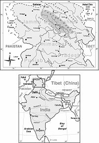
The Spiti Valley is a desert mountain valley located high in the Himalaya mountains in the north-eastern part of the Indian state of Himachal Pradesh
Himachal Pradesh
Himachal Pradesh is a state in Northern India. It is spread over , and is bordered by the Indian states of Jammu and Kashmir on the north, Punjab on the west and south-west, Haryana and Uttar Pradesh on the south, Uttarakhand on the south-east and by the Tibet Autonomous Region on the east...
. The name "Spiti" means "The Middle Land", i.e. the land between Tibet
Tibet Autonomous Region
The Tibet Autonomous Region , Tibet or Xizang for short, also called the Xizang Autonomous Region is a province-level autonomous region of the People's Republic of China , created in 1965....
and India.
It possesses a distinctive Buddhist culture similar to that found in the nearby Tibet Autonomous Region
Tibet Autonomous Region
The Tibet Autonomous Region , Tibet or Xizang for short, also called the Xizang Autonomous Region is a province-level autonomous region of the People's Republic of China , created in 1965....
and the Ladakh
Ladakh
Ladakh is a region of Jammu and Kashmir, the northernmost state of the Republic of India. It lies between the Kunlun mountain range in the north and the main Great Himalayas to the south, inhabited by people of Indo-Aryan and Tibetan descent...
region of India
India
India , officially the Republic of India , is a country in South Asia. It is the seventh-largest country by geographical area, the second-most populous country with over 1.2 billion people, and the most populous democracy in the world...
. The valley and surrounding region is one of the least populated regions in India
India
India , officially the Republic of India , is a country in South Asia. It is the seventh-largest country by geographical area, the second-most populous country with over 1.2 billion people, and the most populous democracy in the world...
and is the gateway to the northernmost reaches of the nation. Along the northern route from Manali, Himachal Pradesh or Keylong
Keylong
Keylong is the administrative centre of the Lahaul and Spiti district in the Indian state of Himachal Pradesh, some 120 kilometres from the Indo-Tibetan border....
via the Rohtang Pass
Rohtang Pass
Rohtang Pass , is a high mountain pass on the eastern Pir Panjal Range of the Himalayas some from Manali...
or Kunzum Pass
Kunzum Pass
Kunzum Pass Kunzum Pass Kunzum Pass (Tibetan: Kunzum La, (el. ), is a high mountain pass on the eastern Kunzum Range of the Himalayas some from Manali. It connects the Kullu Valley and Lahul Valley with the Spiti Valley of Himachal Pradesh, India....
respectively, the valley lies in the North East of the Indian hill state of Himachal Pradesh
Himachal Pradesh
Himachal Pradesh is a state in Northern India. It is spread over , and is bordered by the Indian states of Jammu and Kashmir on the north, Punjab on the west and south-west, Haryana and Uttar Pradesh on the south, Uttarakhand on the south-east and by the Tibet Autonomous Region on the east...
, and forms part of the Lahaul and Spiti district. The sub-divisional headquarters (capital) is Kaza, Himachal Pradesh which is situated along the Spiti River at an elevation of about 12500 feet (3,810 m) above mean sea level.
Lahaul and Spiti is surrounded by high mountain ranges. The Rohtang Pass
Rohtang Pass
Rohtang Pass , is a high mountain pass on the eastern Pir Panjal Range of the Himalayas some from Manali...
, at 13054 feet (3,978.9 m), separates Lahul and Spiti from the Kulu Valley. Lahul and Spiti
Spiti
-Geographical locations:*Lahaul and Spiti, a district in the state of Himachal Pradesh in India.*Spiti Valley, former heartland of the former Spiti district now combined.*Spiti River, in the Spiti Valley, Himachal Pradesh.*Spitia River-Language:...
are cut off from each other by the higher Kunzum Pass
Kunzum Pass
Kunzum Pass Kunzum Pass Kunzum Pass (Tibetan: Kunzum La, (el. ), is a high mountain pass on the eastern Kunzum Range of the Himalayas some from Manali. It connects the Kullu Valley and Lahul Valley with the Spiti Valley of Himachal Pradesh, India....
, at 15059 feet (4,590 m).
The Spiti Valley is a desert mountain valley located high in the Himalaya mountains in the north-eastern part of the Indian state of Himachal Pradesh
Himachal Pradesh
Himachal Pradesh is a state in Northern India. It is spread over , and is bordered by the Indian states of Jammu and Kashmir on the north, Punjab on the west and south-west, Haryana and Uttar Pradesh on the south, Uttarakhand on the south-east and by the Tibet Autonomous Region on the east...
. The name "Spiti" means "The Middle Land", i.e. the land between Tibet
Tibet Autonomous Region
The Tibet Autonomous Region , Tibet or Xizang for short, also called the Xizang Autonomous Region is a province-level autonomous region of the People's Republic of China , created in 1965....
and India.
It possesses a distinctive Buddhist culture similar to that found in the nearby Tibet Autonomous Region
Tibet Autonomous Region
The Tibet Autonomous Region , Tibet or Xizang for short, also called the Xizang Autonomous Region is a province-level autonomous region of the People's Republic of China , created in 1965....
and the Ladakh
Ladakh
Ladakh is a region of Jammu and Kashmir, the northernmost state of the Republic of India. It lies between the Kunlun mountain range in the north and the main Great Himalayas to the south, inhabited by people of Indo-Aryan and Tibetan descent...
region of India
India
India , officially the Republic of India , is a country in South Asia. It is the seventh-largest country by geographical area, the second-most populous country with over 1.2 billion people, and the most populous democracy in the world...
. The valley and surrounding region is one of the least populated regions in India
India
India , officially the Republic of India , is a country in South Asia. It is the seventh-largest country by geographical area, the second-most populous country with over 1.2 billion people, and the most populous democracy in the world...
and is the gateway to the northernmost reaches of the nation. Along the northern route from Manali, Himachal Pradesh or Keylong
Keylong
Keylong is the administrative centre of the Lahaul and Spiti district in the Indian state of Himachal Pradesh, some 120 kilometres from the Indo-Tibetan border....
via the Rohtang Pass
Rohtang Pass
Rohtang Pass , is a high mountain pass on the eastern Pir Panjal Range of the Himalayas some from Manali...
or Kunzum Pass
Kunzum Pass
Kunzum Pass Kunzum Pass Kunzum Pass (Tibetan: Kunzum La, (el. ), is a high mountain pass on the eastern Kunzum Range of the Himalayas some from Manali. It connects the Kullu Valley and Lahul Valley with the Spiti Valley of Himachal Pradesh, India....
respectively, the valley lies in the North East of the Indian hill state of Himachal Pradesh
Himachal Pradesh
Himachal Pradesh is a state in Northern India. It is spread over , and is bordered by the Indian states of Jammu and Kashmir on the north, Punjab on the west and south-west, Haryana and Uttar Pradesh on the south, Uttarakhand on the south-east and by the Tibet Autonomous Region on the east...
, and forms part of the Lahaul and Spiti district. The sub-divisional headquarters (capital) is Kaza, Himachal Pradesh which is situated along the Spiti River at an elevation of about 12500 feet (3,810 m) above mean sea level.
Lahaul and Spiti is surrounded by high mountain ranges. The Rohtang Pass
Rohtang Pass
Rohtang Pass , is a high mountain pass on the eastern Pir Panjal Range of the Himalayas some from Manali...
, at 13054 feet (3,978.9 m), separates Lahul and Spiti from the Kulu Valley. Lahul and Spiti
Spiti
-Geographical locations:*Lahaul and Spiti, a district in the state of Himachal Pradesh in India.*Spiti Valley, former heartland of the former Spiti district now combined.*Spiti River, in the Spiti Valley, Himachal Pradesh.*Spitia River-Language:...
are cut off from each other by the higher Kunzum Pass
Kunzum Pass
Kunzum Pass Kunzum Pass Kunzum Pass (Tibetan: Kunzum La, (el. ), is a high mountain pass on the eastern Kunzum Range of the Himalayas some from Manali. It connects the Kullu Valley and Lahul Valley with the Spiti Valley of Himachal Pradesh, India....
, at 15059 feet (4,590 m). A road connects the two divisions, but is cut off frequently in winter and spring due to heavy snow. The valley is likewise cut off from the north up to eight months of the year by heavy snow
Snow
Snow is a form of precipitation within the Earth's atmosphere in the form of crystalline water ice, consisting of a multitude of snowflakes that fall from clouds. Since snow is composed of small ice particles, it is a granular material. It has an open and therefore soft structure, unless packed by...
falls and thick icing conditions
Ice
Ice is water frozen into the solid state. Usually ice is the phase known as ice Ih, which is the most abundant of the varying solid phases on the Earth's surface. It can appear transparent or opaque bluish-white color, depending on the presence of impurities or air inclusions...
. A southern route to India proper is periodically closed for brief periods in the winter storms of November through June, but road access is usually restored a few days after storms end via Shimla
Shimla
Shimla , formerly known as Simla, is the capital city of Himachal Pradesh. In 1864, Shimla was declared the summer capital of the British Raj in India. A popular tourist destination, Shimla is often referred to as the "Queen of Hills," a term coined by the British...
and the Sutlej valley in the Kinnaur district
Kinnaur district
Kinnaur is one of twelve administrative districts of Himachal Pradesh, India. The district is itself divided into three administrative areas – Pooh, Kalpa, and Nichar – and has five Tehsils or counties. The administrative headquarter for Kinnaur district is at Reckong Peo. Due to the...
.
Culture
Ki Monastery
Key Gompa is a Tibetan Buddhist monastery located on top of a hill at an altitude of above sea level, close to the Spiti River, in the Spiti Valley of Himachal Pradesh, Lahaul and Spiti district, India....
and Tabo Monastery
Tabo Monastery
Tabo Monastery was founded in 996 CE in the Spiti Valley, Himachel Pradesh, India by the great Tibetan Buddhist lotswa , Rinchen Zangpo, the king of western Himalayan Kingdom of Guge...
, one of the oldest monasteries in the world and a favourite of the Dalai Lama
Dalai Lama
The Dalai Lama is a high lama in the Gelug or "Yellow Hat" branch of Tibetan Buddhism. The name is a combination of the Mongolian word далай meaning "Ocean" and the Tibetan word bla-ma meaning "teacher"...
.
It was the location of the spectacular scenery and cinematography in the Indian films Paap
Paap
Paap ) is a 2004 Bollywood film, directed by Pooja Bhatt in her directorial debut, and features John Abraham, Udita Goswami, Gulshan Grover and Mohan Agashe....
and Milarepa , a biographical adventure tale about one of Buddhism
Buddhism
Buddhism is a religion and philosophy encompassing a variety of traditions, beliefs and practices, largely based on teachings attributed to Siddhartha Gautama, commonly known as the Buddha . The Buddha lived and taught in the northeastern Indian subcontinent some time between the 6th and 4th...
's most famous Tibetan saints
Yogi
A Yogi is a practitioner of Yoga. The word is also used to refer to ascetic practitioners of meditation in a number of South Asian Religions including Jainism, Buddhism, and Hinduism.-Etymology:...
. The Buddhist monastery in the valley served as the locus of the set and some of the monks appeared in the film.
The Pin Valley of Spiti is home to the few surviving Buchen Lamas of the Nyingmapa sect of Buddhism.
The small town of Manali was the beginning of an ancient trade route to Ladakh
Ladakh
Ladakh is a region of Jammu and Kashmir, the northernmost state of the Republic of India. It lies between the Kunlun mountain range in the north and the main Great Himalayas to the south, inhabited by people of Indo-Aryan and Tibetan descent...
and, from there, over the Karakoram Pass
Karakoram Pass
The Karakoram Pass is a mountain pass between India and China in the Karakoram Range. It is the highest pass on the ancient caravan route between Leh in Ladakh and Yarkand in the Tarim Basin...
on to Yarkand and Khotan
Khotan
Hotan , or Hetian , also spelled Khotan, is the seat of the Hotan Prefecture in Xinjiang, China. It was previously known in Chinese as 于窴/於窴 and to 19th-century European explorers as Ilchi....
in the Tarim Basin
Tarim Basin
The Tarim Basin is a large endorheic basin occupying an area of about . It is located in the Xinjiang Uyghur Autonomous Region in China's far west. Its northern boundary is the Tian Shan mountain range and its southern is the Kunlun Mountains on the northern edge of the Tibetan Plateau. The...
.
Transport
Spiti valley is accessible throughout year by kinnaur shimla route which is 412 km long and difficult road. Tourists from outside India need inner line permits to enter spiti through kinnaur.Spiti's border start at Samdo[74km from kaza] which is quite near to India-China border. In summer it can be reached via Manali through Rohtang pass and Kunjum pass. Manali is 201 km away from Kaza headquarter of spiti subdivision. Due to high elevation one might feel altitude sickness in spiti.The Spiti River originates from Kunzum range and Tegpo and Kabzian streams are its tributaries. Water draining the famous Pin valley area are also a part of the Spiti river system. Its position across the main Himalayan range deprives it from the benefit of the South-West monsoons that causes widespread rain in most parts of India from June to September. The river attains peak discharge in late summers due to glacier melting. After flowing through Spiti valley, the Spiti River meets Satluj at Namgia in Kinnaur district traversing a length of about 150 km. from the North-West beyond that it flows in South-West direction in the Pradesh. Huge mountain rise to very high ele-vations on either sides of the Spiti River and its numerous tributaries. The mountains are barren and largely devoid of a vegetative cover. The main settlements along the Spiti River and its tributaries are Hansi and Dhankar Gompa.
Responsible travel
Spiti's fragile mountain ecology and its tryst with climate change makes it extremely important that travelers to Spiti leave a positive impact on it, in order for its unique landscape and culture to sustain itself. Ecosphere (social enterprise)Ecosphere (social enterprise)
Ecosphere is a social enterprise that works on the sustainable development of Spiti valley, a cold mountain desert in the Trans-Himalayas of India, by focusing on economic empowerment, environmental conservation & community development...
, a social enterprise set up in Kaza, Spiti's headquarters, assists people to make their travels meaningful and beneficial to Spiti, by developing mitigation and adaptation measures against impacts of climate change
Climate change
Climate change is a significant and lasting change in the statistical distribution of weather patterns over periods ranging from decades to millions of years. It may be a change in average weather conditions or the distribution of events around that average...
, thereby enabling travelers to reduce their emissions. The Spiti River originates from Kunzum range and Tegpo and Kabzian streams are its tributaries. Water draining the famous Pin valley area are also a part of the Spiti river system. Its position across the main Himalayan range deprives it from the benefit of the South-West monsoons that causes widespread rain in most parts of India from June to September. The river attains peak discharge in late summers due to glacier melting. After flowing through Spiti valley, the Spiti River meets Satluj at Namgia in Kinnaur district traversing a length of about 150 km. from the North-West beyond that it flows in South-West direction in the Pradesh. Huge mountain rise to very high ele-vations on either sides of the Spiti River and its numerous tributaries. The mountains are barren and largely devoid of a vegetative cover.
Ecosphere endeavours to make its trips within the region carbon neutral
Carbon neutral
Carbon neutrality, or having a net zero carbon footprint, refers to achieving net zero carbon emissions by balancing a measured amount of carbon released with an equivalent amount sequestered or offset, or buying enough carbon credits to make up the difference...
and provides travelers with options to offset the carbon emitted during their travels by investing in renewable energy
Renewable energy
Renewable energy is energy which comes from natural resources such as sunlight, wind, rain, tides, and geothermal heat, which are renewable . About 16% of global final energy consumption comes from renewables, with 10% coming from traditional biomass, which is mainly used for heating, and 3.4% from...
options such as passive solar houses, green houses, solar water heating systems and cookers, wind energy
Wind energy
Wind energy is the kinetic energy of air in motion; see also wind power.Total wind energy flowing through an imaginary area A during the time t is:E = ½ m v2 = ½ v 2...
alternatives and artificial glaciers. Some of these options can enable travelers to even make their visits carbon positive.