
Black Combe
Encyclopedia
Fell
“Fell” is a word used to refer to mountains, or certain types of mountainous landscape, in Scandinavia, the Isle of Man, and parts of northern England.- Etymology :...
in the south-west corner of the Lake District National Park
Lake District National Park
The Lake District National Park is located in the north-west of England and is the largest of the English National Parks and the second largest in the United Kingdom. It is in the central and most-visited part of the Lake District....
, just four miles from the Irish Sea
Irish Sea
The Irish Sea separates the islands of Ireland and Great Britain. It is connected to the Celtic Sea in the south by St George's Channel, and to the Atlantic Ocean in the north by the North Channel. Anglesey is the largest island within the Irish Sea, followed by the Isle of Man...
. It lies near the west coast of Cumbria
Cumbria
Cumbria , is a non-metropolitan county in North West England. The county and Cumbria County Council, its local authority, came into existence in 1974 after the passage of the Local Government Act 1972. Cumbria's largest settlement and county town is Carlisle. It consists of six districts, and in...
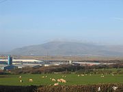
in the borough of Copeland and more specifically, an area known as South Copeland. It is 1970 feet (600m) high and stands in isolation, some 10 miles away from any higher ground; this factor offers an excellent all-round panoramic view of land and sea; weather permitting.
On the seaward side views extend from the Cumbrian coast, round to the Isle of Man
Isle of Man
The Isle of Man , otherwise known simply as Mann , is a self-governing British Crown Dependency, located in the Irish Sea between the islands of Great Britain and Ireland, within the British Isles. The head of state is Queen Elizabeth II, who holds the title of Lord of Mann. The Lord of Mann is...
, 45 miles due west, then round to Snowdon
Snowdon
Snowdon is the highest mountain in Wales, at an altitude of above sea level, and the highest point in the British Isles outside Scotland. It is located in Snowdonia National Park in Gwynedd, and has been described as "probably the busiest mountain in Britain"...
which may be seen on days of exceptionally good visibility, 85 miles to the south, to the coast of Lancashire
Lancashire
Lancashire is a non-metropolitan county of historic origin in the North West of England. It takes its name from the city of Lancaster, and is sometimes known as the County of Lancaster. Although Lancaster is still considered to be the county town, Lancashire County Council is based in Preston...
. On the landward side; views include the Scafell Group and the Coniston Group
Furness Fells
The Furness Fells are those hills and mountains in the Furness region of Cumbria, England. Historically part of Lancashire, the Furness Fells or High Furness is the name given to the upland part of Furness, that is, that part of Furness lying north of the line between Ulverston and Ireleth...
of fells in the Lake District National Park
Lake District National Park
The Lake District National Park is located in the north-west of England and is the largest of the English National Parks and the second largest in the United Kingdom. It is in the central and most-visited part of the Lake District....
, the Pennine Hills
Pennines
The Pennines are a low-rising mountain range, separating the North West of England from Yorkshire and the North East.Often described as the "backbone of England", they form a more-or-less continuous range stretching from the Peak District in Derbyshire, around the northern and eastern edges of...
, the Forest of Bowland
Forest of Bowland
The Forest of Bowland, also known as the Bowland Fells, is an area of barren gritstone fells, deep valleys and peat moorland, mostly in north-east Lancashire, England. A small part lies in North Yorkshire, and much of the area was historically part of the West Riding of Yorkshire...
and Blackpool Tower
Blackpool Tower
Blackpool Tower Eye is a tourist attraction in Blackpool, Lancashire in England which was opened to the public on 14 May 1894. . Inspired by the Eiffel Tower in Paris, it rises to 518 feet & 9 inches . The tower is a member of the World Federation of Great Towers...
. Closer by, there are also good views over the Duddon Estuary
Duddon Estuary
The Duddon Estuary is the sandy, gritty estuary of the River Duddon that lies between Morecambe Bay and the west Cumbrian coast.It opens into the Irish Sea to the north of the Furness peninsula; Walney Island forming part of its southern edge...
, Millom
Millom
Millom is a town and civil parish on the estuary of the River Duddon in the southwest of Cumbria, England. The name is Cumbrian dialect for "At the mills". The town is accessible both by rail and an A class road...
and the new wind farm
Wind farm
A wind farm is a group of wind turbines in the same location used to produce electric power. A large wind farm may consist of several hundred individual wind turbines, and cover an extended area of hundreds of square miles, but the land between the turbines may be used for agricultural or other...
just offshore.
Black Combe is easy to see across Morecambe Bay
Morecambe Bay
Morecambe Bay is a large bay in northwest England, nearly due east of the Isle of Man and just to the south of the Lake District National Park. It is the largest expanse of intertidal mudflats and sand in the United Kingdom, covering a total area of 310 km².-Natural features:The rivers Leven,...
as the most westerly outlying fell of the Lake District National Park
Lake District National Park
The Lake District National Park is located in the north-west of England and is the largest of the English National Parks and the second largest in the United Kingdom. It is in the central and most-visited part of the Lake District....
. The name of the Cumberland View public house in Morecambe reflects the fact that Black Combe used to stand in the historical county of Cumberland
Cumberland
Cumberland is a historic county of North West England, on the border with Scotland, from the 12th century until 1974. It formed an administrative county from 1889 to 1974 and now forms part of Cumbria....
. It can also be seen from the top end of the Wirral peninsula, between the turbines of the new Burbo Bank Offshore Wind Farm
Burbo Bank Offshore Wind Farm
The Burbo Bank Offshore Wind Farm is a wind farm located on the Burbo Flats in Liverpool Bay at the entrance to the River Mersey. It is owned and operated by DONG Energy. The wind farm consists of 25 Siemens Wind Power 3.6MW wind turbines with a total nameplate capacity of 90 megawatts...
.
Clearly visible in views of Black Combe from the south and east is the large, dark coloured glacial corrie
Cirque
Cirque may refer to:* Cirque, a geological formation* Makhtesh, an erosional landform found in the Negev desert of Israel and Sinai of Egypt*Cirque , an album by Biosphere* Cirque Corporation, a company that makes touchpads...
, known as Blackcombe, from which the fell was given its name. Such corries are often known as combes in English place names, a word cognate with the Welsh
Welsh language
Welsh is a member of the Brythonic branch of the Celtic languages spoken natively in Wales, by some along the Welsh border in England, and in Y Wladfa...
word cwm. Adjacent to Blackcombe is a lighter coloured corrie called Whitecombe.
Walks to the top of the fell begin at St Mary's Church, Whicham to the south; St Mary's Church, Whitbeck to the west or from the Corney Fell Road which crosses the fells at an altitude of 1,250 feet four miles to the north of the top. A more challenging and interesting route begins at Beckside Farm on the A595 road and follows Whitecombe Beck before ascending the Horse Back ridge. This ridge separates Blackcombe and Whitecombe on the eastern side of the fell, and gives good views into both combes. The summit plateau is a very flat peat-covered area. There is a Triangulation Pillar
Triangulation station
A triangulation station, also known as a triangulation pillar, trigonometrical station, trigonometrical point, trig station, trig beacon or trig point, and sometimes informally as a trig, is a fixed surveying station, used in geodetic surveying and other surveying projects in its vicinity...
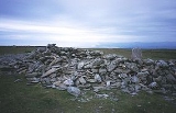
on the top, surrounded by rough drystone wall which forms a wind shelter. 1286 feet due south from the peak is a lesser peak upon which stands a large cairn
Cairn
Cairn is a term used mainly in the English-speaking world for a man-made pile of stones. It comes from the or . Cairns are found all over the world in uplands, on moorland, on mountaintops, near waterways and on sea cliffs, and also in barren desert and tundra areas...
which is easily visible with the naked eye from Millom
Millom
Millom is a town and civil parish on the estuary of the River Duddon in the southwest of Cumbria, England. The name is Cumbrian dialect for "At the mills". The town is accessible both by rail and an A class road...
and the surrounding area. Between this cairn
Cairn
Cairn is a term used mainly in the English-speaking world for a man-made pile of stones. It comes from the or . Cairns are found all over the world in uplands, on moorland, on mountaintops, near waterways and on sea cliffs, and also in barren desert and tundra areas...
and the top, in a shallow valley, lies a small tarn
Tarn (lake)
A tarn is a mountain lake or pool, formed in a cirque excavated by a glacier. A moraine may form a natural dam below a tarn. A corrie may be called a cirque.The word is derived from the Old Norse word tjörn meaning pond...
.
The rocks of Black Combe belong to the Skiddaw Slates sequence
Skiddaw Slate
Skiddaw slate is an early Ordovician metamorphosed sedimentary rock, as first identified on the slopes of Skiddaw in the English Lake District....
, sedimentary strata from the Ordovician
Ordovician
The Ordovician is a geologic period and system, the second of six of the Paleozoic Era, and covers the time between 488.3±1.7 to 443.7±1.5 million years ago . It follows the Cambrian Period and is followed by the Silurian Period...
era, largely mudstones, siltstones and occasional sandstones or greywackes. The nearby Millom Park includes Millom Rock Park, open to the public almost 24/7.
Black Combe was given a chapter in Alfred Wainwright
Alfred Wainwright
Alfred Wainwright MBE was a British fellwalker, guidebook author and illustrator. His seven-volume Pictorial Guide to the Lakeland Fells, published between 1955 and 1966 and consisting entirely of reproductions of his manuscript, has become the standard reference work to 214 of the fells of the...
's book Outlying Fells of Lakeland. At 600m, it is only 10m short of being a Hewitt. Sub-tops include White Combe, Stoupdale Head, Swinside Fell and Stoneside Hill.
External links
- Computer generated summit panorama Black Combe index
- Millom Rock Park
- Millom and South Copeland community website
- Cumbria County Council
- Copeland Borough Council
- Lake District National Park Authority
- Millom Town Council Website
- Local attractions
- The official tourist board website for Cumbria and the Lake District