
South Yamhill River
Encyclopedia
The South Yamhill River is a tributary of the Yamhill River
, approximately 60 miles (96.6 km) long, in northwest Oregon
in the United States
. It drains an area of the Northern Oregon Coast Range, as well as part of the Willamette Valley
west of the Willamette River
.
and falls 476 feet (145.1 m) between source and mouth to an elevation of 75 feet (22.9 m). It begins at the confluence of Hanchet Creek and Kitten Creek in the Siuslaw National Forest
of the Northern Oregon Coast Range
. The source, at about river mile
(RM) 60 or river kilometer (RK) 97 lies near the border between Tillamook
and Yamhill
counties west of the Grand Ronde Community, an Indian reservation
.
Flowing southeast on the north side of Oregon Route 22 in Yamhill County, the river receives Pierce Creek and Ead Creek from the left, and Cedar Creek from the right before flowing under the highway at about RM 57 (RK 92). Continuing parallel to the highway, which lies to its left, the river receives Crooked Creek from the left and Elmer Creek from the right before passing Midway and entering Polk County at about RM 55 (RK 89). Just beyond the county border, Agency Creek enters from the left. About 1 miles (1.6 km) later, the river receives the Rogue River
from the left, reaches Grand Ronde, and passes under Grand Ronde Road and Oregon Route 18, a highway connecting the Portland metropolitan area
to the Oregon Coast
. Shortly thereafter, Rock Creek enters from the right.
Turning east and running roughly parallel to Route 18, the river receives Rowell Creek from the right before passing under the highway for the second time at Valley Junction
and receiving Casper Creek from the left at about RM 50 (RK 80). Running north of Route 18 for about 1 miles (1.6 km), the stream receives Klees Creek from the left and passes under the highway for the third time at Fort Hill. Flowing south of the highway, the river receives Gold Creek, Lady Creek, and Doane Creek, all from the right, and Cockerham Creek from the left before passing under Route 18 for the fourth time at about RM 45 (RK 72). Shortly thereafter, it reaches Willamina, re-entering Yamhill County and receiving Willamina Creek from the left at about RM 43 (RK 69). About 2 miles (3.2 km) later, Ash Creek enters from the left.
Continuing generally east and running between West Valley Highway on the left and Route 18 on the right, the river meanders slightly north of east, receiving Mill Creek from the right and Rock Creek from the left before reaching Sheridan at about RM 38 (RK 61). About 1 miles (1.6 km) later, it passes under Route 18 for the fifth time and meanders generally east until turning north, still roughly parallel to the highway, at RM 30 (RK 48). About 5 miles (8 km) later, Deer Creek enters from the left, and 7 miles (11.3 km) later, Salt Creek enters from the right. Shortly thereafter, the South Yamhill River passes under Oregon Route 99W and continues northeast toward McMinnville Municipal Airport
. In a series of wide meanders starting at about RM 10 (RK 16), the river turns away from the airport and flows under Route 18 for the sixth and last time at RM 5.6 (RK 9.0), the site of a stream gauge
maintained by the United States Geological Survey
(USGS). The river flows by the east side of McMinnville, where it receives Cozine Creek from the left. It continues generally northeast to join the North Yamhill River
to form the Yamhill River, an 11 miles (17.7 km) tributary of the Willamette River.
Yamhill River
The Yamhill River is an tributary of the Willamette River, in the U.S. state of Oregon. Formed by the confluence of the South Yamhill River and the North Yamhill River about east of McMinnville, it drains part of the Northern Oregon Coast Range...
, approximately 60 miles (96.6 km) long, in northwest Oregon
Oregon
Oregon is a state in the Pacific Northwest region of the United States. It is located on the Pacific coast, with Washington to the north, California to the south, Nevada on the southeast and Idaho to the east. The Columbia and Snake rivers delineate much of Oregon's northern and eastern...
in the United States
United States
The United States of America is a federal constitutional republic comprising fifty states and a federal district...
. It drains an area of the Northern Oregon Coast Range, as well as part of the Willamette Valley
Willamette Valley
The Willamette Valley is the most populated region in the state of Oregon of the United States. Located in the state's northwest, the region is surrounded by tall mountain ranges to the east, west and south and the valley's floor is broad, flat and fertile because of Ice Age conditions...
west of the Willamette River
Willamette River
The Willamette River is a major tributary of the Columbia River, accounting for 12 to 15 percent of the Columbia's flow. The Willamette's main stem is long, lying entirely in northwestern Oregon in the United States...
.
Course
The South Yamhill River rises at an elevation of 551 feet (167.9 m) above sea levelSea level
Mean sea level is a measure of the average height of the ocean's surface ; used as a standard in reckoning land elevation...
and falls 476 feet (145.1 m) between source and mouth to an elevation of 75 feet (22.9 m). It begins at the confluence of Hanchet Creek and Kitten Creek in the Siuslaw National Forest
Siuslaw National Forest
Siuslaw National Forest is a national forest in western Oregon, United States. Established in 1908, the Siuslaw is made up of a wide variety of ecosystems, ranging from coastal forests to sand dunes.- Geography :...
of the Northern Oregon Coast Range
Northern Oregon Coast Range
The Northern Oregon Coast Range is the northern section of the Oregon Coast Range, in the Pacific Coast Ranges physiographic region, located in the northwest portion of the state of Oregon, United States. This section of the mountain range, part of the Pacific Coast Ranges, contains peaks as high...
. The source, at about river mile
River mile
In the United States, a River mile is a measure of distance in miles along a river from its mouth. River mile numbers begin at zero and increase further upstream. The corresponding metric unit using kilometers is the River kilometer...
(RM) 60 or river kilometer (RK) 97 lies near the border between Tillamook
Tillamook County, Oregon
Tillamook County is a county located in the U.S. state of Oregon. The county is named for the Tillamook, a Native American tribe who were living in the area in the early 19th century at the time of European American settlement. In 2010, the county's population was 25,250...
and Yamhill
Yamhill County, Oregon
-National protected areas:*Siuslaw National Forest *Tualatin River National Wildlife Refuge -Demographics:As of the census of 2000, there were 84,992 people, 28,732 households, and 21,376 families residing in the county. The population density was 119 people per square mile . There were 30,270...
counties west of the Grand Ronde Community, an Indian reservation
Indian reservation
An American Indian reservation is an area of land managed by a Native American tribe under the United States Department of the Interior's Bureau of Indian Affairs...
.
Flowing southeast on the north side of Oregon Route 22 in Yamhill County, the river receives Pierce Creek and Ead Creek from the left, and Cedar Creek from the right before flowing under the highway at about RM 57 (RK 92). Continuing parallel to the highway, which lies to its left, the river receives Crooked Creek from the left and Elmer Creek from the right before passing Midway and entering Polk County at about RM 55 (RK 89). Just beyond the county border, Agency Creek enters from the left. About 1 miles (1.6 km) later, the river receives the Rogue River
Rogue River (South Yamhill River)
The Rogue River is a tributary of the South Yamhill River in Polk County, Oregon, United States. It enters the South Yamhill about north of Grand Ronde...
from the left, reaches Grand Ronde, and passes under Grand Ronde Road and Oregon Route 18, a highway connecting the Portland metropolitan area
Portland metropolitan area
The Portland-Vancouver-Hillsboro, OR-WA Metropolitan Statistical Area , also known as the Portland metropolitan area or Greater Portland, is an urban area in the U.S. states of Oregon and Washington centered around the city of Portland, Oregon. The U.S...
to the Oregon Coast
Oregon Coast
The Oregon Coast is a region of the U.S. state of Oregon. It runs generally north-south along the Pacific Ocean, forming the western border of the state; the region is bounded to the east by the Oregon Coast Range. The Oregon Coast stretches approximately from the Columbia River in the north to...
. Shortly thereafter, Rock Creek enters from the right.
Turning east and running roughly parallel to Route 18, the river receives Rowell Creek from the right before passing under the highway for the second time at Valley Junction
Valley Junction, Oregon
Valley Junction is an unincorporated community in Polk County, Oregon, United States. It is located at the junction of Oregon Route 18 and Oregon Route 22, on the South Yamhill River east of Grand Ronde. A now-abandoned section of the Willamina and Grand Ronde Railway short line passed through...
and receiving Casper Creek from the left at about RM 50 (RK 80). Running north of Route 18 for about 1 miles (1.6 km), the stream receives Klees Creek from the left and passes under the highway for the third time at Fort Hill. Flowing south of the highway, the river receives Gold Creek, Lady Creek, and Doane Creek, all from the right, and Cockerham Creek from the left before passing under Route 18 for the fourth time at about RM 45 (RK 72). Shortly thereafter, it reaches Willamina, re-entering Yamhill County and receiving Willamina Creek from the left at about RM 43 (RK 69). About 2 miles (3.2 km) later, Ash Creek enters from the left.
Continuing generally east and running between West Valley Highway on the left and Route 18 on the right, the river meanders slightly north of east, receiving Mill Creek from the right and Rock Creek from the left before reaching Sheridan at about RM 38 (RK 61). About 1 miles (1.6 km) later, it passes under Route 18 for the fifth time and meanders generally east until turning north, still roughly parallel to the highway, at RM 30 (RK 48). About 5 miles (8 km) later, Deer Creek enters from the left, and 7 miles (11.3 km) later, Salt Creek enters from the right. Shortly thereafter, the South Yamhill River passes under Oregon Route 99W and continues northeast toward McMinnville Municipal Airport
McMinnville Municipal Airport
McMinnville Municipal Airport is a city-owned public-use airport located three nautical miles southeast of the central business district of McMinnville, a city in Yamhill County, Oregon, United States...
. In a series of wide meanders starting at about RM 10 (RK 16), the river turns away from the airport and flows under Route 18 for the sixth and last time at RM 5.6 (RK 9.0), the site of a stream gauge
Stream gauge
A stream gauge, stream gage or gauging station is a location used by hydrologists or environmental scientists to monitor and test terrestrial bodies of water. Hydrometric measurements of water surface elevation and/or volumetric discharge are generally taken and observations of biota may also be...
maintained by the United States Geological Survey
United States Geological Survey
The United States Geological Survey is a scientific agency of the United States government. The scientists of the USGS study the landscape of the United States, its natural resources, and the natural hazards that threaten it. The organization has four major science disciplines, concerning biology,...
(USGS). The river flows by the east side of McMinnville, where it receives Cozine Creek from the left. It continues generally northeast to join the North Yamhill River
North Yamhill River
The North Yamhill River is a tributary of the Yamhill River in the U.S. state of Oregon. It drains an area of the Northern Oregon Coast Range, as well as part of the Willamette Valley west of the Willamette River....
to form the Yamhill River, an 11 miles (17.7 km) tributary of the Willamette River.
River levels
The National Weather Service measures river levels at two locations along the South Yamhill River. Near Willamina, the highest recorded water level was about 17 feet (5 m) in December 1964. No low-water records are available for this gauge. At McMinnville, the highest recorded water level was about 59 feet (18 m) in February 1996, and the lowest was zero in October 1996.See also
- List of rivers of Oregon
- List of longest streams of Oregon
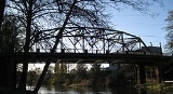
- Sheridan BridgeSheridan Bridge (Oregon)Sheridan Bridge in is a two-lane steel Truss bridge carrying vehicular traffic in Sheridan, Oregon, United States. Construction began in 1938 and finished in 1939. This bridge connects the northern part and southern part of the town across the South Yamhill River in Yamhill...