

South Petherton
Encyclopedia
South Petherton is a small country town and civil parish
on the River Parrett
in the South Somerset
district of Somerset
, England
. It is 5 miles (8 km) east of Ilminster
and 5 miles (8 km) north west of Crewkerne
. It had a population of approximately 3,200 in 2002. The parish includes the hamlets of Yeabridge, Compton-Durvill, South Harp, and Over Stratton, and is approximately 2 miles (3 km) from East Lambrook, Martock
and Lopen
.
It is distinctive for the traditional hamstone
construction of many of its buildings.
A site on Lightgate Road, north of the present town, has produced Iron Age occupation material, though archaeological evidence of any structures have not yet been discovered. Roman material, mostly consisting of coins, has also been discovered locally and, as it is only 2 miles (3 km) from the Fosse Way
, roman occupation is likely, although it may have been abandoned between the 4th and 8th centuries.
The Saxon Chronicle of 680 refers to a major battle on the site of the village and the Saxon Ine of Wessex
of the Kingdom of Wessex built a palace on present day Silver Street.
A large royal estate of South Petherton was created and the Saxon settlement, Sudperetone (the southern tun on the Parrett), included a minster church, a royal palace and a short-lived 11th century mint
. Most of the royal estate passed directly to William the Conqueror and was still a possession of the Crown in 1086. The parish was part of the South Petherton
Hundred. Part of the estate was also held by Bruton Abbey
from the 12th century until the Dissolution of the Monasteries
, then becoming known as the manor of Hele. In 1213 a royal warrant by King John
was granted for a market and fair, but by 1243 the main manor had been granted away from the Crown under Henry II
and by 1243 South Petherton manor was owned outright by the Daubeney family
, who continued to hold it until the late 15th century, the family dying out after Henry Daubeney acquired the earldom of Bridgwater
and then failed to produce an heir to succeed him.
The manor reverted to the Crown in 1553, before passing into the ownership of the Arundells of Wardour
, in which it remained until 1792, when it was sold to John Baker Edmonds. John Baker Edmonds also acquired the rectory estate of South Petherton (known also as the manor of Hele), which had had a complicated history of ownership, including purchase in 1753 by Henry Hele
, a successful physician from Salisbury.
Another estate (known as the Manor of Wigborough) was shared by members of the Brome Family from 1581 to 1615, when it passed to the family of Hele of Flete (unconnected to the Henry Hele referred to above) who held it for most of the 17th century.
During the English Civil War
troops from both sides occupied the town during 1644 and 1645. The town also had a role in the Monmouth rebellion
of 1680 and two townsmen were among those who prosecuted in the Bloody Assizes
.
It was also recently discovered that South Petherton was, during the 17th century, one of the main centres of bronze cauldron and skillet production. These cooking vessels were used all over the UK.
In 1947 a 17th century house on West Street was converted into the Under-Sheriff's Office, and is now offices for a law firm founded in 1749.
In 2005 South Petherton was awarded ‘Somerset Village of the Year’ in a national competition.
During 2007 Somerset Primary Care Trust consulted local residents about proposals for the redevelopment of South Petherton Community Hospital, which provides Out Patient Assessment and Reablement services.
South Petherton has its own parish council with responsibility for local issues, including setting an annual precept (local rate) to cover the council’s operating costs and producing annual accounts for public scrutiny. The parish council evaluates local planning applications and works with the local police, district council officers, and neighbourhood watch
groups on matters of crime, security, and traffic. The council's role also includes initiating projects for the maintenance and repair of parish facilities, as well as consulting with the district council on the maintenance, repair, and improvement of highways, drainage, footpaths, public transport, and street cleaning. Conservation matters (including trees and listed buildings) and environmental issues are also the responsibility of the council. The town is part of the South Somerset
local government district
within the wider Somerset County Council
.
Yeovil is a county constituency represented in the House of Commons
of the Parliament of the United Kingdom
. It elects one Member of Parliament (MP)
by the first past the post system of election. The constituency covers the towns of Yeovil, Chard
, Crewkerne
and Ilminster
in Somerset
. Until 1983 Somerset
was split into four constituencies and Yeovil constituency also contained the towns of Ilchester
, Martock
and Somerton
but they were moved into the newly created constituency of Somerton and Frome. From the next election, Yeovil constituency will contain Ilchester
once again to equalise the populations of the Somerset constituencies. The Boundary Commission for England estimate the electorate of Yeovil constituency after the pending boundary changes to be 77,049. The current MP is David Laws
, a member of the Liberal Democrats.
Residents of South Petherton also form part of the electorate for the South West England
constituency for elections to the European Parliament
.
hills to the west, the flat wetland area of the Somerset Levels
and Moors to the north, and the hills of Dorset
to the south.
It lies on low lying undulating land of Yeovil Sands at the foot of a limestone
ridge, which has been quarried for Petherton stone, and for sands and clays suitable for brick and tile making.
, South Petherton has a temperate climate which is generally wetter and milder than the rest of the country. The annual mean temperature is approximately 10 °C (50 °F). Seasonal temperature variation is less extreme than most of the United Kingdom because of the adjacent sea temperatures. The summer months of July and August are the warmest with mean daily maxima of approximately 21 °C (69.8 °F). In winter mean minimum temperatures of 1 °C (33.8 °F) or 2 °C (35.6 °F) are common. In the summer the Azores
high pressure affects the south-west of England, however convective cloud sometimes forms inland, reducing the number of hours of sunshine. Annual sunshine rates are slightly less than the regional average of 1,600 hours. In December 1998 there were 20 days without sun recorded at Yeovilton. Most the rainfall in the south-west is caused by Atlantic depressions or by convection
. Most of the rainfall in autumn and winter is caused by the Atlantic depressions, which is when they are most active. In summer, a large proportion of the rainfall is caused by sun heating the ground leading to convection and to showers and thunderstorms. Average rainfall is around 700 mm (27.6 in). About 8–15 days of snowfall is typical. November to March have the highest mean wind speeds, and June to August have the lightest winds. The predominant wind direction is from the south-west.
Cloth manufacture, continued into the late 18th and 19th century although this was largely replaced by sailcloth and then leather working. The importance of this industry can be seen by the number of mills which remain including; the former flax mill or granary in Hayes End, Joylers Mill, Shutlers Mill, and the former flax mill immediately north of Flaxdrayton Farmhouse.
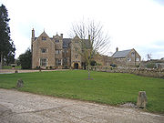 In Silver Street is a 14th century manor house. It was restored in the 19th century and nicknamed 'King Ina's Palace'.
The 15th or 16th century Wigborough Manor House
was never completed to its original plans and has subsequently been modified many times.
Approximately 1 miles (2 km) from the town is East Lambrook Manor Gardens created by Margery Fish who was known as the 'Leading Lady of Gardening' from the 1950s until her death in 1969. It holds the national collection of geraniums, and a collection of snowdrops.
The "David Hall" is a local social centre run by the Petherton Arts Trust, a non-profit making organisation formed in 1986 and registered as a charity in 1990. There is also the "Blake Hall" which has a social club downstairs and a hall upstairs where a market is held on the first Sunday of every month, as well as various other activities.
(Stanchester Community School), Crewkerne
(Wadham
) and Huish Episcopi
(Huish Episcopi School
).
main road, and the nearest railway stations are in Crewkerne and Yeovil. Formerly there were closer stations at Martock
and Ilminster, but both of these were closed in the 1960s.
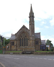
Church of St Peter and St Paul
has Saxon
origins. It retains a 13th century crosswing, with the remainder of the buildings dating from the 15th century, however it underwent major restorations in the late 19th and early 20th centuries. It has been designated by English Heritage
as a grade I listed building. The tower is an irregular octagon on plan, wider on east-west axis, which is believed to be the tallest octagonal church tower in the UK.
 The Coke Memorial Methodist Church was built in 1881 replacing an 1809 chapel on the site. It was named after Thomas Coke
, who was curate of the village 1772-76 and important, along with John Wesley
, amongst the founders of Methodism.
A United Reform Church was built in 1863. This is now used as a public hall.
The Recreation Ground provides pitches for football and cricket
clubs and there are also facilities for tennis
and bowls
and a children’s play area.
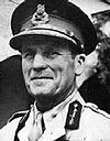 John Harding, 1st Baron Harding of Petherton
(1896–1989)
Civil parish
In England, a civil parish is a territorial designation and, where they are found, the lowest tier of local government below districts and counties...
on the River Parrett
River Parrett
The River Parrett flows through the counties of Dorset and Somerset in South West England, from its source in the Thorney Mills springs in the hills around Chedington in Dorset...
in the South Somerset
South Somerset
South Somerset is a local government district in Somerset, England.The South Somerset district covers and area of ranging from the borders with Devon and Dorset to the edge of the Somerset Levels. It has a population of approximately 158,000...
district of Somerset
Somerset
The ceremonial and non-metropolitan county of Somerset in South West England borders Bristol and Gloucestershire to the north, Wiltshire to the east, Dorset to the south-east, and Devon to the south-west. It is partly bounded to the north and west by the Bristol Channel and the estuary of the...
, England
England
England is a country that is part of the United Kingdom. It shares land borders with Scotland to the north and Wales to the west; the Irish Sea is to the north west, the Celtic Sea to the south west, with the North Sea to the east and the English Channel to the south separating it from continental...
. It is 5 miles (8 km) east of Ilminster
Ilminster
Ilminster is a country town and civil parish in the countryside of south west Somerset, England, with a population of 4,781. Bypassed a few years ago, the town now lies just east of the intersection of the A303 and the A358...
and 5 miles (8 km) north west of Crewkerne
Crewkerne
Crewkerne is a town in Somerset, England, situated south west of Yeovil and east of Chard in the South Somerset district close to the border with Dorset. The civil parish of West Crewkerne includes the hamlets of Woolminstone and Henley...
. It had a population of approximately 3,200 in 2002. The parish includes the hamlets of Yeabridge, Compton-Durvill, South Harp, and Over Stratton, and is approximately 2 miles (3 km) from East Lambrook, Martock
Martock
Martock is a large village and civil parish in Somerset, England, situated on the edge of the Somerset Levels north west of Yeovil in the South Somerset district. The parish includes Hurst, approximately one mile south of the village, and Bower Hinton, which is located at the western end of the...
and Lopen
Lopen
Lopen is a village and civil parish in the English county of Somerset, situated eight miles west of Yeovil in the South Somerset district. The village has a population of 248.-History:The name of the village means Lufa's pen or fold....
.
It is distinctive for the traditional hamstone
Hamstone
Hamstone is the colloquial name given to stone from Ham Hill, Somerset, England. Hamstone is a Jurassic limestone from the Toarcian, or Upper Lias, stage. It is a well cemented medium to coarse grained limestone characterised by its honey-gold colour and marked bedding planes. The stone contains...
construction of many of its buildings.
History
The town's name may come from the Old English word Pared meaning boundary and the Saxon word ton meaning settlement, forming ’Paredton’.A site on Lightgate Road, north of the present town, has produced Iron Age occupation material, though archaeological evidence of any structures have not yet been discovered. Roman material, mostly consisting of coins, has also been discovered locally and, as it is only 2 miles (3 km) from the Fosse Way
Fosse Way
The Fosse Way was a Roman road in England that linked Exeter in South West England to Lincoln in Lincolnshire, via Ilchester , Bath , Cirencester and Leicester .It joined Akeman Street and Ermin Way at Cirencester, crossed Watling Street at Venonis south...
, roman occupation is likely, although it may have been abandoned between the 4th and 8th centuries.
The Saxon Chronicle of 680 refers to a major battle on the site of the village and the Saxon Ine of Wessex
Ine of Wessex
Ine was King of Wessex from 688 to 726. He was unable to retain the territorial gains of his predecessor, Cædwalla, who had brought much of southern England under his control and expanded West Saxon territory substantially...
of the Kingdom of Wessex built a palace on present day Silver Street.
A large royal estate of South Petherton was created and the Saxon settlement, Sudperetone (the southern tun on the Parrett), included a minster church, a royal palace and a short-lived 11th century mint
Mint (coin)
A mint is an industrial facility which manufactures coins for currency.The history of mints correlates closely with the history of coins. One difference is that the history of the mint is usually closely tied to the political situation of an era...
. Most of the royal estate passed directly to William the Conqueror and was still a possession of the Crown in 1086. The parish was part of the South Petherton
South Petherton (hundred)
The Hundred of South Petherton is one of the 40 historical Hundreds in the ceremonial county of Somerset, England, dating from before the Norman conquest during the Anglo-Saxon era although exact dates are unknown. Each hundred had a 'fyrd', which acted as the local defence force and a court which...
Hundred. Part of the estate was also held by Bruton Abbey
Bruton Abbey
Bruton Abbey in Bruton, Somerset was originally founded as a Benedictine priory by Algar, Earl of Cornwall in about 1005. It was subsequently refounded as a house of Augustinian canons in 1135, by William de Mohun, who later became the Earl of Somerset. The village used the north aisle of the...
from the 12th century until the Dissolution of the Monasteries
Dissolution of the Monasteries
The Dissolution of the Monasteries, sometimes referred to as the Suppression of the Monasteries, was the set of administrative and legal processes between 1536 and 1541 by which Henry VIII disbanded monasteries, priories, convents and friaries in England, Wales and Ireland; appropriated their...
, then becoming known as the manor of Hele. In 1213 a royal warrant by King John
John of England
John , also known as John Lackland , was King of England from 6 April 1199 until his death...
was granted for a market and fair, but by 1243 the main manor had been granted away from the Crown under Henry II
Henry II of England
Henry II ruled as King of England , Count of Anjou, Count of Maine, Duke of Normandy, Duke of Aquitaine, Duke of Gascony, Count of Nantes, Lord of Ireland and, at various times, controlled parts of Wales, Scotland and western France. Henry, the great-grandson of William the Conqueror, was the...
and by 1243 South Petherton manor was owned outright by the Daubeney family
Baron Daubeny
The title Baron Daubeny was an ancient one in the Peerage of England. It was created in 1295 when Elias Daubeny was summoned to parliament. The eighth baron was again created Baron Daubeny in 1486; the status of that creation is unclear...
, who continued to hold it until the late 15th century, the family dying out after Henry Daubeney acquired the earldom of Bridgwater
Bridgwater
Bridgwater is a market town and civil parish in Somerset, England. It is the administrative centre of the Sedgemoor district, and a major industrial centre. Bridgwater is located on the major communication routes through South West England...
and then failed to produce an heir to succeed him.
The manor reverted to the Crown in 1553, before passing into the ownership of the Arundells of Wardour
Baron Arundell of Wardour
Baron Arundell of Wardour, in the County of Wiltshire, was a title in the Peerage of England. It was created in 1605 for Thomas Arundell, known as "Thomas the Valiant". He was the grandson of Sir Thomas Arundell and Margaret Howard, sister of Queen Catherine Howard. Arundell had already been...
, in which it remained until 1792, when it was sold to John Baker Edmonds. John Baker Edmonds also acquired the rectory estate of South Petherton (known also as the manor of Hele), which had had a complicated history of ownership, including purchase in 1753 by Henry Hele
Henry Hele
Henry Hele M.D. was an English physician, who became a substantial landowner in Wiltshire and Somerset.-Origins:Hele was the son of Richard Hele, of the Close, Sarum, whose will described him as “gentleman”...
, a successful physician from Salisbury.
Another estate (known as the Manor of Wigborough) was shared by members of the Brome Family from 1581 to 1615, when it passed to the family of Hele of Flete (unconnected to the Henry Hele referred to above) who held it for most of the 17th century.
During the English Civil War
English Civil War
The English Civil War was a series of armed conflicts and political machinations between Parliamentarians and Royalists...
troops from both sides occupied the town during 1644 and 1645. The town also had a role in the Monmouth rebellion
Monmouth Rebellion
The Monmouth Rebellion,The Revolt of the West or The West Country rebellion of 1685, was an attempt to overthrow James II, who had become King of England, King of Scots and King of Ireland at the death of his elder brother Charles II on 6 February 1685. James II was a Roman Catholic, and some...
of 1680 and two townsmen were among those who prosecuted in the Bloody Assizes
Bloody Assizes
The Bloody Assizes were a series of trials started at Winchester on 25 August 1685 in the aftermath of the Battle of Sedgemoor, which ended the Monmouth Rebellion in England....
.
It was also recently discovered that South Petherton was, during the 17th century, one of the main centres of bronze cauldron and skillet production. These cooking vessels were used all over the UK.
In 1947 a 17th century house on West Street was converted into the Under-Sheriff's Office, and is now offices for a law firm founded in 1749.
In 2005 South Petherton was awarded ‘Somerset Village of the Year’ in a national competition.
During 2007 Somerset Primary Care Trust consulted local residents about proposals for the redevelopment of South Petherton Community Hospital, which provides Out Patient Assessment and Reablement services.
Governance
As a civil parishCivil parish
In England, a civil parish is a territorial designation and, where they are found, the lowest tier of local government below districts and counties...
South Petherton has its own parish council with responsibility for local issues, including setting an annual precept (local rate) to cover the council’s operating costs and producing annual accounts for public scrutiny. The parish council evaluates local planning applications and works with the local police, district council officers, and neighbourhood watch
Neighbourhood Watch (UK)
The Neighbourhood Watch scheme in the United Kingdom is a partnership where people come together to make their communities safer. It involves the Police, Community Safety departments of local authorities, other voluntary organisations and, above all, individuals and families who want to make their...
groups on matters of crime, security, and traffic. The council's role also includes initiating projects for the maintenance and repair of parish facilities, as well as consulting with the district council on the maintenance, repair, and improvement of highways, drainage, footpaths, public transport, and street cleaning. Conservation matters (including trees and listed buildings) and environmental issues are also the responsibility of the council. The town is part of the South Somerset
South Somerset
South Somerset is a local government district in Somerset, England.The South Somerset district covers and area of ranging from the borders with Devon and Dorset to the edge of the Somerset Levels. It has a population of approximately 158,000...
local government district
Non-metropolitan district
Non-metropolitan districts, or colloquially shire districts, are a type of local government district in England. As created, they are sub-divisions of non-metropolitan counties in a so-called "two-tier" arrangement...
within the wider Somerset County Council
Somerset County Council
Somerset County Council is the county council of Somerset in the South West of England, an elected local government authority responsible for the most significant local government services in most of the county.-Area covered:...
.
Yeovil is a county constituency represented in the House of Commons
British House of Commons
The House of Commons is the lower house of the Parliament of the United Kingdom, which also comprises the Sovereign and the House of Lords . Both Commons and Lords meet in the Palace of Westminster. The Commons is a democratically elected body, consisting of 650 members , who are known as Members...
of the Parliament of the United Kingdom
Parliament of the United Kingdom
The Parliament of the United Kingdom of Great Britain and Northern Ireland is the supreme legislative body in the United Kingdom, British Crown dependencies and British overseas territories, located in London...
. It elects one Member of Parliament (MP)
Member of Parliament
A Member of Parliament is a representative of the voters to a :parliament. In many countries with bicameral parliaments, the term applies specifically to members of the lower house, as upper houses often have a different title, such as senate, and thus also have different titles for its members,...
by the first past the post system of election. The constituency covers the towns of Yeovil, Chard
Chard, Somerset
Chard is a town and civil parish in the Somerset county of England. It lies on the A30 road near the Devon border, south west of Yeovil. The parish has a population of approximately 12,000 and, at an elevation of , it is the southernmost and highest town in Somerset...
, Crewkerne
Crewkerne
Crewkerne is a town in Somerset, England, situated south west of Yeovil and east of Chard in the South Somerset district close to the border with Dorset. The civil parish of West Crewkerne includes the hamlets of Woolminstone and Henley...
and Ilminster
Ilminster
Ilminster is a country town and civil parish in the countryside of south west Somerset, England, with a population of 4,781. Bypassed a few years ago, the town now lies just east of the intersection of the A303 and the A358...
in Somerset
Somerset
The ceremonial and non-metropolitan county of Somerset in South West England borders Bristol and Gloucestershire to the north, Wiltshire to the east, Dorset to the south-east, and Devon to the south-west. It is partly bounded to the north and west by the Bristol Channel and the estuary of the...
. Until 1983 Somerset
Somerset
The ceremonial and non-metropolitan county of Somerset in South West England borders Bristol and Gloucestershire to the north, Wiltshire to the east, Dorset to the south-east, and Devon to the south-west. It is partly bounded to the north and west by the Bristol Channel and the estuary of the...
was split into four constituencies and Yeovil constituency also contained the towns of Ilchester
Ilchester
Ilchester is a village and civil parish, situated on the River Yeo or Ivel, five miles north of Yeovil, in the English county of Somerset. The parish, which includes the village of Sock Dennis and the old parish of Northover, has a population of 2,021...
, Martock
Martock
Martock is a large village and civil parish in Somerset, England, situated on the edge of the Somerset Levels north west of Yeovil in the South Somerset district. The parish includes Hurst, approximately one mile south of the village, and Bower Hinton, which is located at the western end of the...
and Somerton
Somerton
Somerton is a small town and civil parish in the South Somerset district of the English county of Somerset. It gave its name to the county of Somerset, was briefly, around the start of the 14th century, the county town, and around 900 AD was possibly the capital of Wessex...
but they were moved into the newly created constituency of Somerton and Frome. From the next election, Yeovil constituency will contain Ilchester
Ilchester
Ilchester is a village and civil parish, situated on the River Yeo or Ivel, five miles north of Yeovil, in the English county of Somerset. The parish, which includes the village of Sock Dennis and the old parish of Northover, has a population of 2,021...
once again to equalise the populations of the Somerset constituencies. The Boundary Commission for England estimate the electorate of Yeovil constituency after the pending boundary changes to be 77,049. The current MP is David Laws
David Laws
David Anthony Laws is a British politician. He is Liberal Democrat Member of Parliament for Yeovil and former Chief Secretary to the Treasury....
, a member of the Liberal Democrats.
Residents of South Petherton also form part of the electorate for the South West England
South West England (European Parliament constituency)
South West England is a constituency of the European Parliament. For 2009 it elects 6 MEPs using the d'Hondt method of party-list proportional representation, reduced from 7 in 2004.-Boundaries:...
constituency for elections to the European Parliament
European Parliament
The European Parliament is the directly elected parliamentary institution of the European Union . Together with the Council of the European Union and the Commission, it exercises the legislative function of the EU and it has been described as one of the most powerful legislatures in the world...
.
Geography
South Petherton is situated between the DevonDevon
Devon is a large county in southwestern England. The county is sometimes referred to as Devonshire, although the term is rarely used inside the county itself as the county has never been officially "shired", it often indicates a traditional or historical context.The county shares borders with...
hills to the west, the flat wetland area of the Somerset Levels
Somerset Levels
The Somerset Levels, or the Somerset Levels and Moors as they are less commonly but more correctly known, is a sparsely populated coastal plain and wetland area of central Somerset, South West England, between the Quantock and Mendip Hills...
and Moors to the north, and the hills of Dorset
Dorset
Dorset , is a county in South West England on the English Channel coast. The county town is Dorchester which is situated in the south. The Hampshire towns of Bournemouth and Christchurch joined the county with the reorganisation of local government in 1974...
to the south.
It lies on low lying undulating land of Yeovil Sands at the foot of a limestone
Limestone
Limestone is a sedimentary rock composed largely of the minerals calcite and aragonite, which are different crystal forms of calcium carbonate . Many limestones are composed from skeletal fragments of marine organisms such as coral or foraminifera....
ridge, which has been quarried for Petherton stone, and for sands and clays suitable for brick and tile making.
Climate
Along with the rest of South West EnglandSouth West England
South West England is one of the regions of England defined by the Government of the United Kingdom for statistical and other purposes. It is the largest such region in area, covering and comprising Bristol, Gloucestershire, Somerset, Dorset, Wiltshire, Devon, Cornwall and the Isles of Scilly. ...
, South Petherton has a temperate climate which is generally wetter and milder than the rest of the country. The annual mean temperature is approximately 10 °C (50 °F). Seasonal temperature variation is less extreme than most of the United Kingdom because of the adjacent sea temperatures. The summer months of July and August are the warmest with mean daily maxima of approximately 21 °C (69.8 °F). In winter mean minimum temperatures of 1 °C (33.8 °F) or 2 °C (35.6 °F) are common. In the summer the Azores
Azores
The Archipelago of the Azores is composed of nine volcanic islands situated in the middle of the North Atlantic Ocean, and is located about west from Lisbon and about east from the east coast of North America. The islands, and their economic exclusion zone, form the Autonomous Region of the...
high pressure affects the south-west of England, however convective cloud sometimes forms inland, reducing the number of hours of sunshine. Annual sunshine rates are slightly less than the regional average of 1,600 hours. In December 1998 there were 20 days without sun recorded at Yeovilton. Most the rainfall in the south-west is caused by Atlantic depressions or by convection
Convection
Convection is the movement of molecules within fluids and rheids. It cannot take place in solids, since neither bulk current flows nor significant diffusion can take place in solids....
. Most of the rainfall in autumn and winter is caused by the Atlantic depressions, which is when they are most active. In summer, a large proportion of the rainfall is caused by sun heating the ground leading to convection and to showers and thunderstorms. Average rainfall is around 700 mm (27.6 in). About 8–15 days of snowfall is typical. November to March have the highest mean wind speeds, and June to August have the lightest winds. The predominant wind direction is from the south-west.
Economy
Agriculture has traditionally been an important local industry, although South Petherton has also been a centre for glove making, cider production and other cottage industries at various points in its history.Cloth manufacture, continued into the late 18th and 19th century although this was largely replaced by sailcloth and then leather working. The importance of this industry can be seen by the number of mills which remain including; the former flax mill or granary in Hayes End, Joylers Mill, Shutlers Mill, and the former flax mill immediately north of Flaxdrayton Farmhouse.
Landmarks
The 15th or 16th century Wigborough Manor House
Wigborough Manor House
Wigborough Manor House in South Petherton, Somerset, England was partly built in 1585 although never completed to the original designs and subsequently modified. It has been designated as a Grade I listed building....
was never completed to its original plans and has subsequently been modified many times.
Approximately 1 miles (2 km) from the town is East Lambrook Manor Gardens created by Margery Fish who was known as the 'Leading Lady of Gardening' from the 1950s until her death in 1969. It holds the national collection of geraniums, and a collection of snowdrops.
The "David Hall" is a local social centre run by the Petherton Arts Trust, a non-profit making organisation formed in 1986 and registered as a charity in 1990. There is also the "Blake Hall" which has a social club downstairs and a hall upstairs where a market is held on the first Sunday of every month, as well as various other activities.
Education
Education is provided within the town by two nurseries for pre-school children, an infants’ school (ages 5–7) and a junior school (ages 7–11). The nearest secondary schools are in Stoke-sub-HamdonStoke-sub-Hamdon
Stoke-sub-Hamdon is a village and civil parish in South Somerset, situated west of Yeovil, England. The parish is located near the River Parrett, and includes the village of East Stoke.-History:...
(Stanchester Community School), Crewkerne
Crewkerne
Crewkerne is a town in Somerset, England, situated south west of Yeovil and east of Chard in the South Somerset district close to the border with Dorset. The civil parish of West Crewkerne includes the hamlets of Woolminstone and Henley...
(Wadham
Wadham Community School
Wadham School is a school for children aged 13–18 situated on a site on the outskirts of Crewkerne in Somerset, England. - School site:...
) and Huish Episcopi
Huish Episcopi
Huish Episcopi is a village and civil parish in Somerset, England, situated on the outskirts of Langport, south west of Somerton in the South Somerset district...
(Huish Episcopi School
Huish Episcopi School
Huish Episcopi Academy is a mixed secondary school with academy status, for ages 11 to 18 located in Huish Episcopi near Langport, Somerset, England. The current Principal is Graham Roff. The school has a specialist status as a Science College and Language College. It has around 1,240 students...
).
Transport
South Petherton is located close to the A303A303 road
The A303 is a 92-mile long trunk road in England. It is the main road between Basingstoke in Hampshire and Honiton in Devon. The M3, the A303 and the A30 together make up one of the main routes from London to South West England, running from London to Land's End in Cornwall...
main road, and the nearest railway stations are in Crewkerne and Yeovil. Formerly there were closer stations at Martock
Martock
Martock is a large village and civil parish in Somerset, England, situated on the edge of the Somerset Levels north west of Yeovil in the South Somerset district. The parish includes Hurst, approximately one mile south of the village, and Bower Hinton, which is located at the western end of the...
and Ilminster, but both of these were closed in the 1960s.
Religious sites
The Church of EnglandChurch of England
The Church of England is the officially established Christian church in England and the Mother Church of the worldwide Anglican Communion. The church considers itself within the tradition of Western Christianity and dates its formal establishment principally to the mission to England by St...
Church of St Peter and St Paul
Church of St Peter and St Paul, South Petherton
The Church of St Peter and St Paul in South Petherton, Somerset, England has Saxon origins. It retains a 13th century crosswing, with the remainder of the buildings dating from the 15th century, however it underwent major restorations in the late 19th and early 20th centuries...
has Saxon
Anglo-Saxons
Anglo-Saxon is a term used by historians to designate the Germanic tribes who invaded and settled the south and east of Great Britain beginning in the early 5th century AD, and the period from their creation of the English nation to the Norman conquest. The Anglo-Saxon Era denotes the period of...
origins. It retains a 13th century crosswing, with the remainder of the buildings dating from the 15th century, however it underwent major restorations in the late 19th and early 20th centuries. It has been designated by English Heritage
English Heritage
English Heritage . is an executive non-departmental public body of the British Government sponsored by the Department for Culture, Media and Sport...
as a grade I listed building. The tower is an irregular octagon on plan, wider on east-west axis, which is believed to be the tallest octagonal church tower in the UK.
Thomas Coke (bishop)
Thomas Coke was the first Methodist Bishop and is known as the Father of Methodist Missions.Born in Brecon, south Wales, his father was a well-to-do apothecary...
, who was curate of the village 1772-76 and important, along with John Wesley
John Wesley
John Wesley was a Church of England cleric and Christian theologian. Wesley is largely credited, along with his brother Charles Wesley, as founding the Methodist movement which began when he took to open-air preaching in a similar manner to George Whitefield...
, amongst the founders of Methodism.
A United Reform Church was built in 1863. This is now used as a public hall.
Sports
The South Petherton Walking Group is aimed at the over 50's and aims to encourage this healthy, social activity amongst residents and visitors.The Recreation Ground provides pitches for football and cricket
Cricket
Cricket is a bat-and-ball game played between two teams of 11 players on an oval-shaped field, at the centre of which is a rectangular 22-yard long pitch. One team bats, trying to score as many runs as possible while the other team bowls and fields, trying to dismiss the batsmen and thus limit the...
clubs and there are also facilities for tennis
Tennis
Tennis is a sport usually played between two players or between two teams of two players each . Each player uses a racket that is strung to strike a hollow rubber ball covered with felt over a net into the opponent's court. Tennis is an Olympic sport and is played at all levels of society at all...
and bowls
Bowls
Bowls is a sport in which the objective is to roll slightly asymmetric balls so that they stop close to a smaller "jack" or "kitty". It is played on a pitch which may be flat or convex or uneven...
and a children’s play area.
Notable people
John Harding, 1st Baron Harding of Petherton
Field Marshal Allan Francis John Harding, 1st Baron Harding of Petherton, GCB, CBE, DSO, MC was a British Army officer and Governor of Cyprus from 1955 to 1957, Cyprus being a British colony at that time....
(1896–1989)