
Snow Canyon State Park
Encyclopedia
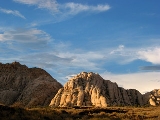
Snow Canyon State Park is a state park
of Utah
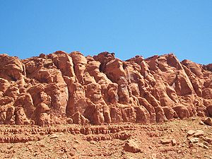
, USA, featuring a canyon carved from the red and white Navajo sandstone
in the Red Mountains. The park is located near Ivins, Utah
in Washington County
. Other geological features of the state park include extinct cinder cones
, lava tube
s, lava flows
, and sand dunes
.
settlers Lorenzo
and Erastus Snow
. It was designated as a Utah State Park in 1958.
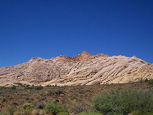
Two canyons, West Canyon and Snow Canyon, begin side-by-side at the north gouging deeply into the sandstone
of the Red Mountains, each canyon then running southward, slowly converging then finally meeting in the middle of the park. From there Snow Canyon continues south-by-southeastward as a single, larger canyon. Near the park's southern entrance, the canyon ends, its mouth opening out onto the Santa Clara
bench near Ivins, Utah
.
 A paved two-lane road (formerly SR-300) enters the park from Ivins on the south, winds up the canyon a ways, then climbs up the eastern edge to the bench above Snow Canyon, where the road joins State Route 18
. Ancient lava flows spill over the eastern edges of Snow Canyon from above, where the road climbs out of the canyon.
The park boundaries extend northeastward, across State Route 18
, to encompass two cinder cones along the western edge of Diamond Valley.
The highest point in the park, according to a U.S. Geological Survey
topographical map, is a peak 5024 feet (1,531.3 m) in elevation nearly due west of the southern cinder cone, standing above the eastern edge of the east fork of Snow Canyon.
 Snow Canyon sits at the junction of the Mojave Desert
, Great Basin
, and Colorado Plateau
. The climate is typical of that of a desert climate. In the higher elevations the climate tends to be both dry and cooler. In the lower elevations the climate is also dry, but the temperatures are much warmer.
Summers are hot with low temperatures in the low 80 degrees Fahrenheit to high temperatures over 105 °F (40.6 °C). Winters can range from lows in the mid 20 degrees Fahrenheit to highs in the 60 degrees Fahrenheit ranges.
inhabited the region from AD 200-1250, utilizing the canyon for hunting and gathering. Paiute Indians used the canyon from AD 1200 to the mid-19th century. Mormon pioneers discovered Snow Canyon in the 1850s while searching for lost cattle. The canyon has been the site of Hollywood films such as Butch Cassidy and the Sundance Kid
, The Electric Horseman
, and Jeremiah Johnson. Originally called Dixie State Park, it was later renamed for Lorenzo and Erastus Snow, prominent pioneering Utah leaders.
 Wildlife in Snow Canyon includes three endangered species: the Gila monster
, Peregrine Falcon
, and Desert Tortoise
. Small fences to keep the ground-dwelling creatures from accidentally wandering onto roads can be seen across Snow Canyon and the St. George area. Other notable wildlife include the giant desert hairy scorpion
, coyote
, Mojave sidewinder
, red-spotted toad
, Utah banded gecko, and the side-blotched lizard
, among many others.
Johnson Canyon - (Open November 15 to March 1 only) - 2 miles (3.2 km). Easy. Level with some rocky slopes and steps. Boasting the only riparian area in the park, this trail winds through lava flows and red rock to an arch spanning 200 feet (61 m).
Jenny's Canyon - (Closed March 31 to June 1) -One-half mile. Easy, level with few slopes and steps. Trail leads to a narrow, sculpted canyon then splits with rock stair steps to offer a scenic overlook.
Sand Dunes - One-half mile. Easy. Deep sand with some slopes. Trail leads to a large expanse of red sand that is an excellent play area for children of all ages.
West Canyon Road - 7 miles (11.3 km). Easy. Gravel and sand surface. Fairly level. Trail follows a maintenance road winding past washes and towering cliffs to the mouth of present-day Snow Canyon.
Pioneer Names - One-half mile. Easy. Fairly level with some steps and slopes. This crescent-shaped trail passes pioneer names written in axle grease, dating back to 1883.
Hidden Pinyon - 1.5 miles (2.4 km). Moderate. Rocky slopes. Drop-offs. This self-guided nature trail introduces geological features and native plants of the park.
Three Ponds - 3.5 miles (5.6 km). Moderate. Some rocky slopes. Deep sand. Trail winds through sandy washes to mouth of a 400 feet (121.9 m) canyon. Potholes eroded in sandstone catch seasonal rain, giving the trail its name.
Petrified Dunes Trail - 1 miles (1.6 km). Moderate. Some steep slopes, uneven surfaces. This trail crosses massive sandstone outcrops where you may explore sand dunes frozen in time.
Butterfly Trail - 2 miles (3.2 km). Moderate. Some steep slopes, steps and uneven surfaces. Winding along the west side of Petrified Dunes, this trail leads to West Canyon Overlook and lava tubes.
White Rocks Trail/Lava Flow Overlook - 4 miles (6.4 km). Moderate. Some rocky slopes, uneven surfaces. Passing through lava flows, juniper stands and breathtaking views of West Canyon, trail leads to a natural amphitheater set in white sandstone. Or reach the amphitheater on a 1 miles (1.6 km) trail located one-half mile north of State Route 18 junction.
State park
State parks are parks or other protected areas managed at the federated state level within those nations which use "state" as a political subdivision. State parks are typically established by a state to preserve a location on account of its natural beauty, historic interest, or recreational...
of Utah
Utah
Utah is a state in the Western United States. It was the 45th state to join the Union, on January 4, 1896. Approximately 80% of Utah's 2,763,885 people live along the Wasatch Front, centering on Salt Lake City. This leaves vast expanses of the state nearly uninhabited, making the population the...
, USA, featuring a canyon carved from the red and white Navajo sandstone
Navajo Sandstone
Navajo Sandstone is a geologic formation in the Glen Canyon Group that is spread across the U.S. states of northern Arizona, northwest Colorado, and Utah; as part of the Colorado Plateau province of the United States...
in the Red Mountains. The park is located near Ivins, Utah
Ivins, Utah
Ivins is a city in Washington County, Utah, United States. The population was 4,450 at the 2000 census, and it was estimated at 7,205 in 2006. Although Ivins was a town in 2000, it has since been classified as a fifth-class city by state law.-History:...
in Washington County
Washington County, Utah
As of the census of 2000, there were 90,354 people, 29,939 households, and 23,442 families residing in the county. The population density was 37 people per square mile . There were 36,478 housing units at an average density of 15 per square mile...
. Other geological features of the state park include extinct cinder cones
Santa Clara Volcano
Santa Clara Volcano is a volcanic field and lava flow in southwest Utah. The most prominent features are two cinder cones that rise above Snow Canyon. The southern cinder cone and most of the north cinder cone are within the boundaries of Snow Canyon State Park. The city of St. George, Utah is...
, lava tube
Lava tube
Lava tubes are natural conduits through which lava travels beneath the surface of a lava flow, expelled by a volcano during an eruption. They can be actively draining lava from a source, or can be extinct, meaning the lava flow has ceased and the rock has cooled and left a long, cave-like...
s, lava flows
Lava
Lava refers both to molten rock expelled by a volcano during an eruption and the resulting rock after solidification and cooling. This molten rock is formed in the interior of some planets, including Earth, and some of their satellites. When first erupted from a volcanic vent, lava is a liquid at...
, and sand dunes
Dune
In physical geography, a dune is a hill of sand built by wind. Dunes occur in different forms and sizes, formed by interaction with the wind. Most kinds of dunes are longer on the windward side where the sand is pushed up the dune and have a shorter "slip face" in the lee of the wind...
.
About
Snow Canyon is named after early MormonMormon
The term Mormon most commonly denotes an adherent, practitioner, follower, or constituent of Mormonism, which is the largest branch of the Latter Day Saint movement in restorationist Christianity...
settlers Lorenzo
Lorenzo Snow
Lorenzo Snow was the fifth president of The Church of Jesus Christ of Latter-day Saints from 1898 to his death. Snow was the last president of the LDS Church in the nineteenth century.-Family:...
and Erastus Snow
Erastus Snow
Erastus Fairbanks Snow , born in St. Johnsbury, Vermont, was a member of the Quorum of the Twelve Apostles of The Church of Jesus Christ of Latter-day Saints from 1849 to 1888. Snow was also a leading figure in Mormon colonization of Arizona, Colorado, and New Mexico.Snow Canyon State Park Erastus...
. It was designated as a Utah State Park in 1958.
Two canyons, West Canyon and Snow Canyon, begin side-by-side at the north gouging deeply into the sandstone
Sandstone
Sandstone is a sedimentary rock composed mainly of sand-sized minerals or rock grains.Most sandstone is composed of quartz and/or feldspar because these are the most common minerals in the Earth's crust. Like sand, sandstone may be any colour, but the most common colours are tan, brown, yellow,...
of the Red Mountains, each canyon then running southward, slowly converging then finally meeting in the middle of the park. From there Snow Canyon continues south-by-southeastward as a single, larger canyon. Near the park's southern entrance, the canyon ends, its mouth opening out onto the Santa Clara
Santa Clara, Utah
Santa Clara is a city in Washington County, Utah, United States. The population was 4,630 at the 2000 census.-Geography:According to the United States Census Bureau, the city has a total area of 4.9 square miles , of which, 4.9 square miles of it is land and 0.04 square miles of it...
bench near Ivins, Utah
Ivins, Utah
Ivins is a city in Washington County, Utah, United States. The population was 4,450 at the 2000 census, and it was estimated at 7,205 in 2006. Although Ivins was a town in 2000, it has since been classified as a fifth-class city by state law.-History:...
.
Utah State Route 18
State Route 18 is a state highway in southern Utah, running for in Washington and Iron Counties from St. George to Beryl Junction. It forms part of the Legacy Loop Highway from St. George to Parowan. The highway closely follows the route of the Old Spanish Trail through Dixie National Forest.-St...
. Ancient lava flows spill over the eastern edges of Snow Canyon from above, where the road climbs out of the canyon.
The park boundaries extend northeastward, across State Route 18
Utah State Route 18
State Route 18 is a state highway in southern Utah, running for in Washington and Iron Counties from St. George to Beryl Junction. It forms part of the Legacy Loop Highway from St. George to Parowan. The highway closely follows the route of the Old Spanish Trail through Dixie National Forest.-St...
, to encompass two cinder cones along the western edge of Diamond Valley.
The highest point in the park, according to a U.S. Geological Survey
United States Geological Survey
The United States Geological Survey is a scientific agency of the United States government. The scientists of the USGS study the landscape of the United States, its natural resources, and the natural hazards that threaten it. The organization has four major science disciplines, concerning biology,...
topographical map, is a peak 5024 feet (1,531.3 m) in elevation nearly due west of the southern cinder cone, standing above the eastern edge of the east fork of Snow Canyon.
Facilities
Snow Canyon State Park is open all year round and contains 35 campsites for tents and RVs below 35 feet (10.7 m). The day-use fee is $6. Hikers and bikers may obtain annual passes for $15 (increased to $21 in 2009 and $24 in 2010). The Johnson Canyon trail (to a large arch) below the toll gate at the south entrance to the park may be accessed without payment of fees, but is closed to hikers most of the year, to protect nesting bird populations. The Johnson Canyon trail is usually only open from about November 15 to March.Climate
Mojave Desert
The Mojave Desert occupies a significant portion of southeastern California and smaller parts of central California, southern Nevada, southwestern Utah and northwestern Arizona, in the United States...
, Great Basin
Great Basin
The Great Basin is the largest area of contiguous endorheic watersheds in North America and is noted for its arid conditions and Basin and Range topography that varies from the North American low point at Badwater Basin to the highest point of the contiguous United States, less than away at the...
, and Colorado Plateau
Colorado Plateau
The Colorado Plateau, also called the Colorado Plateau Province, is a physiographic region of the Intermontane Plateaus, roughly centered on the Four Corners region of the southwestern United States. The province covers an area of 337,000 km2 within western Colorado, northwestern New Mexico,...
. The climate is typical of that of a desert climate. In the higher elevations the climate tends to be both dry and cooler. In the lower elevations the climate is also dry, but the temperatures are much warmer.
Summers are hot with low temperatures in the low 80 degrees Fahrenheit to high temperatures over 105 °F (40.6 °C). Winters can range from lows in the mid 20 degrees Fahrenheit to highs in the 60 degrees Fahrenheit ranges.
History
Created in 1958, Snow Canyon has a long history of human use. Ancestral PuebloansAncient Pueblo Peoples
Ancient Pueblo People or Ancestral Pueblo peoples were an ancient Native American culture centered on the present-day Four Corners area of the United States, comprising southern Utah, northern Arizona, northwest New Mexico, and southern Colorado...
inhabited the region from AD 200-1250, utilizing the canyon for hunting and gathering. Paiute Indians used the canyon from AD 1200 to the mid-19th century. Mormon pioneers discovered Snow Canyon in the 1850s while searching for lost cattle. The canyon has been the site of Hollywood films such as Butch Cassidy and the Sundance Kid
Butch Cassidy and the Sundance Kid
Butch Cassidy and the Sundance Kid is a 1969 American Western film directed by George Roy Hill and written by William Goldman...
, The Electric Horseman
The Electric Horseman
The Electric Horseman is a 1979 adventure and romance feature film starring Robert Redford and Jane Fonda and directed by Sydney Pollack. It was the third time Redford and Fonda starred together in a feature film, having previously teamed on The Chase and Barefoot in the Park .-Plot:Sonny Steele ...
, and Jeremiah Johnson. Originally called Dixie State Park, it was later renamed for Lorenzo and Erastus Snow, prominent pioneering Utah leaders.
Flora and fauna
The vegetation of the area mainly consists of desert plants, such as scrub, yucca, flowering and non-flowering cacti, and sagebrush.Gila monster
The Gila monster is a species of venomous lizard native to the southwestern United States and northwestern Mexican state of Sonora...
, Peregrine Falcon
Peregrine Falcon
The Peregrine Falcon , also known as the Peregrine, and historically as the Duck Hawk in North America, is a widespread bird of prey in the family Falconidae. A large, crow-sized falcon, it has a blue-gray back, barred white underparts, and a black head and "moustache"...
, and Desert Tortoise
Desert Tortoise
The desert tortoise is a species of tortoise native to the Mojave desert and Sonoran desert of the southwestern United States and northwestern Mexico. They can be located in western Arizona, southeastern California, southern Nevada, and southwestern Utah. The species name agassizii is in honor of...
. Small fences to keep the ground-dwelling creatures from accidentally wandering onto roads can be seen across Snow Canyon and the St. George area. Other notable wildlife include the giant desert hairy scorpion
Giant desert hairy scorpion
Hadrurus arizonensis, the giant desert hairy scorpion, giant hairy scorpion, or Arizona Desert hairy scorpion, is the largest scorpion in North America, and one of the 8–9 species of Hadrurus in the United States, attaining a length of . Its large size allows it to feed readily on other scorpions...
, coyote
Coyote
The coyote , also known as the American jackal or the prairie wolf, is a species of canine found throughout North and Central America, ranging from Panama in the south, north through Mexico, the United States and Canada...
, Mojave sidewinder
Crotalus cerastes
Crotalus cerastes is a venomous pitviper species found in the desert regions of the southwestern United States and northwestern Mexico. Three subspecies are currently recognized, including the nominate subspecies described here.-Description:...
, red-spotted toad
Bufo punctatus
The Red-spotted toad is a small toad species growing to 3.7 to 7.5 centimeters in length. It has a flattened head and body, and a light grey, olive or reddish brown dorsum with reddish or orange skin glands. It has a whitish or buff venter with or without faint dark spotting, and round parotoid...
, Utah banded gecko, and the side-blotched lizard
Side-blotched lizard
Side-blotched lizards are lizards of the genus Uta. They are some of the most abundant and commonly observed lizards in the deserts of western North America. They commonly grow to six inches including the tail, with the males normally being the larger sex. Males often have bright throat colors....
, among many others.
Trails
Whiptail Trail - 6 miles (9.7 km). Easy. Level with some slopes. Accessible to physically challenged. Tucked along the canyon bottom, this sinuous paved trail is suitable for hiking, jogging, biking and rollerblading.Johnson Canyon - (Open November 15 to March 1 only) - 2 miles (3.2 km). Easy. Level with some rocky slopes and steps. Boasting the only riparian area in the park, this trail winds through lava flows and red rock to an arch spanning 200 feet (61 m).
Jenny's Canyon - (Closed March 31 to June 1) -One-half mile. Easy, level with few slopes and steps. Trail leads to a narrow, sculpted canyon then splits with rock stair steps to offer a scenic overlook.
Sand Dunes - One-half mile. Easy. Deep sand with some slopes. Trail leads to a large expanse of red sand that is an excellent play area for children of all ages.
West Canyon Road - 7 miles (11.3 km). Easy. Gravel and sand surface. Fairly level. Trail follows a maintenance road winding past washes and towering cliffs to the mouth of present-day Snow Canyon.
Pioneer Names - One-half mile. Easy. Fairly level with some steps and slopes. This crescent-shaped trail passes pioneer names written in axle grease, dating back to 1883.
Hidden Pinyon - 1.5 miles (2.4 km). Moderate. Rocky slopes. Drop-offs. This self-guided nature trail introduces geological features and native plants of the park.
Three Ponds - 3.5 miles (5.6 km). Moderate. Some rocky slopes. Deep sand. Trail winds through sandy washes to mouth of a 400 feet (121.9 m) canyon. Potholes eroded in sandstone catch seasonal rain, giving the trail its name.
Petrified Dunes Trail - 1 miles (1.6 km). Moderate. Some steep slopes, uneven surfaces. This trail crosses massive sandstone outcrops where you may explore sand dunes frozen in time.
Butterfly Trail - 2 miles (3.2 km). Moderate. Some steep slopes, steps and uneven surfaces. Winding along the west side of Petrified Dunes, this trail leads to West Canyon Overlook and lava tubes.
White Rocks Trail/Lava Flow Overlook - 4 miles (6.4 km). Moderate. Some rocky slopes, uneven surfaces. Passing through lava flows, juniper stands and breathtaking views of West Canyon, trail leads to a natural amphitheater set in white sandstone. Or reach the amphitheater on a 1 miles (1.6 km) trail located one-half mile north of State Route 18 junction.