

Smolyan
Encyclopedia
Smolyan is a town and ski resort in the very south of Bulgaria
not far from the border with Greece
. It is the administrative and industrial centre of the homonymous Smolyan Province
. The town is situated in the valley of the Cherna ("Black") and the Byala
("White") Rivers in the central Rhodopes at the foot of the mountain
s' highest part south of the popular ski
resorts Pamporovo
and Chepelare
. As of February 2011, it has a population of 30,283 inhabitants.
-1st millennium BC
. In the Middle Ages it acquired its name from the Slavic
tribe, the Smolyani
, who settled in the region in the 7th century. During the Middle Ages
, it was ruled by the Part of the Byzantine
and Bulgarian Empires
. For a while during the 14th-century it came under the control of the Bulgarian feudal lord Momchil
, alongside the whole Rhodope mountains
, before eventually being subjugated by the Ottoman Empire
. Smolyan remained under Ottoman rule for five centuries, a township of the Ottoman Gümülcine
sanjak
in Edirne
vilayet between 1867 and 1912. It was known in Ottoman Turkish
as Paşmaklı or Ahiçelebi.
The area was liberated by the 21st Sredna Gora
Regiment led by Vladimir Serafimov in 1912, during the First Balkan War
. The modern town of Smolyan was formed by the merger of three existing villages — Ustovo, Raykovo and Ezerovo — in 1960.
was about 5,000. Since then it started growing decade by decade, mostly because of the migrants from the rural areas and the surrounding smaller towns, reaching its peak in the beginning of the 1990s, exceeding 34,000.
in operation in the town. There is one theatre, the Rhodope
Drama Theatre, and a gathering of theatre practitioners and scholars known as The Rhodopi International Theatre Laboratory is held every summer. There is also a regional historical museum founded in 1935.
Smolyan has an elite division football team, PFC Rodopa Smolyan
, that had been playing in the A Professional Football Group between 2003-2007.
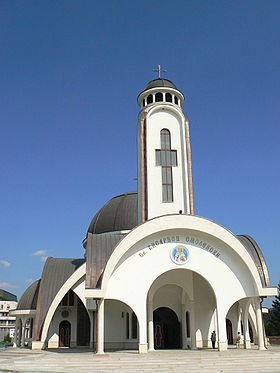
The largest church in southern Bulgaria, the Cathedral of Saint Vissarion of Smolyan
, was inaugurated in the city in July 2006.
on Livingston Island in the South Shetland Islands
, Antarctica is named after Smolyan.
Bulgaria
Bulgaria , officially the Republic of Bulgaria , is a parliamentary democracy within a unitary constitutional republic in Southeast Europe. The country borders Romania to the north, Serbia and Macedonia to the west, Greece and Turkey to the south, as well as the Black Sea to the east...
not far from the border with Greece
Greece
Greece , officially the Hellenic Republic , and historically Hellas or the Republic of Greece in English, is a country in southeastern Europe....
. It is the administrative and industrial centre of the homonymous Smolyan Province
Smolyan Province
-Religion:The Smolyan province along with the Kardzhali Province is a province where the predominant religion is not Orthodox Christianity but Islam. However, unlike Kardzhali where the majority of the population is Turkish, the Muslim population of the Smolyan province is made up almost entirely...
. The town is situated in the valley of the Cherna ("Black") and the Byala
Byala
Byala might refer to:* Byala, Varna Province, a town in Varna Province in northeastern Bulgaria* Byala, Rousse Province, a town in Rousse Province in northern Bulgaria* Byala, Sliven Province, a village in Sliven Province in southeastern Bulgaria...
("White") Rivers in the central Rhodopes at the foot of the mountain
Mountain
Image:Himalaya_annotated.jpg|thumb|right|The Himalayan mountain range with Mount Everestrect 58 14 160 49 Chomo Lonzorect 200 28 335 52 Makalurect 378 24 566 45 Mount Everestrect 188 581 920 656 Tibetan Plateaurect 250 406 340 427 Rong River...
s' highest part south of the popular ski
Ski
A ski is a long, flat device worn on the foot, usually attached through a boot, designed to help the wearer slide smoothly over snow. Originally intended as an aid to travel in snowy regions, they are now mainly used for recreational and sporting purposes...
resorts Pamporovo
Pamporovo
Pamporovo is a popular ski resort in Smolyan Province, southern Bulgaria, one of the best-known in Southeastern Europe. It is set amongst magnificent pine forests and is primarily visited during the winter for skiing and snowboarding. It is also a popular tourist place in summer. The hub of...
and Chepelare
Chepelare
Chepelare is a town and ski resort in Smolyan Province in Southern Bulgaria. It is situated in the central part of the Rhodopes, on the banks of Chepelare River. Chepelare is a popular winter resort with one of the longest ski runs in Southeastern Europe. It is located near Pamporovo, one of the...
. As of February 2011, it has a population of 30,283 inhabitants.
History
According to archaeological evidence, the area around Smolyan was first settled in the 2nd2nd millennium BC
The 2nd millennium BC marks the transition from the Middle to the Late Bronze Age.Its first half is dominated by the Middle Kingdom of Egypt and Babylonia. The alphabet develops. Indo-Iranian migration onto the Iranian plateau and onto the Indian subcontinent propagates the use of the chariot...
-1st millennium BC
1st millennium BC
The 1st millennium BC encompasses the Iron Age and sees the rise of many successive empires, and spanned from 1000 BC to 1 BC.The Neo-Assyrian Empire, followed by the Achaemenids. In Greece, Classical Antiquity begins with the colonization of Magna Graecia and peaks with the rise of Hellenism. The...
. In the Middle Ages it acquired its name from the Slavic
Slavic peoples
The Slavic people are an Indo-European panethnicity living in Eastern Europe, Southeast Europe, North Asia and Central Asia. The term Slavic represents a broad ethno-linguistic group of people, who speak languages belonging to the Slavic language family and share, to varying degrees, certain...
tribe, the Smolyani
Smolyani
The Smolyani were a medieval Slavic tribe that settled in the Rhodope Mountains, the valley of the Mesta River and the region around Blagoevgrad Province, possibly in the 7th-8th century...
, who settled in the region in the 7th century. During the Middle Ages
Middle Ages
The Middle Ages is a periodization of European history from the 5th century to the 15th century. The Middle Ages follows the fall of the Western Roman Empire in 476 and precedes the Early Modern Era. It is the middle period of a three-period division of Western history: Classic, Medieval and Modern...
, it was ruled by the Part of the Byzantine
Byzantine Empire
The Byzantine Empire was the Eastern Roman Empire during the periods of Late Antiquity and the Middle Ages, centred on the capital of Constantinople. Known simply as the Roman Empire or Romania to its inhabitants and neighbours, the Empire was the direct continuation of the Ancient Roman State...
and Bulgarian Empires
First Bulgarian Empire
The First Bulgarian Empire was a medieval Bulgarian state founded in the north-eastern Balkans in c. 680 by the Bulgars, uniting with seven South Slavic tribes...
. For a while during the 14th-century it came under the control of the Bulgarian feudal lord Momchil
Momchil
Momchil was a 14th-century Bulgarian brigand and local ruler. Initially a member of a bandit gang in the borderlands of Bulgaria, Byzantium and Serbia, Momchil was recruited by the Byzantines as a mercenary...
, alongside the whole Rhodope mountains
Rhodope Mountains
The Rhodopes are a mountain range in Southeastern Europe, with over 83% of its area in southern Bulgaria and the remainder in Greece. Its highest peak, Golyam Perelik , is the seventh highest Bulgarian mountain...
, before eventually being subjugated by the Ottoman Empire
Ottoman Empire
The Ottoman EmpireIt was usually referred to as the "Ottoman Empire", the "Turkish Empire", the "Ottoman Caliphate" or more commonly "Turkey" by its contemporaries...
. Smolyan remained under Ottoman rule for five centuries, a township of the Ottoman Gümülcine
Komotini
Komotini is a city in Thrace, northeastern Greece. It is the capital of the region of East Macedonia and Thrace and of the Rhodope regional unit. It is also the administrative center of the Rhodope-Evros super-prefecture. The city is home to the Democritus University of Thrace, founded in 1973...
sanjak
Sanjak
Sanjaks were administrative divisions of the Ottoman Empire. Sanjak, and the variant spellings sandjak, sanjaq, and sinjaq, are English transliterations of the Turkish word sancak, meaning district, banner, or flag...
in Edirne
Edirne
Edirne is a city in Eastern Thrace, the northwestern part of Turkey, close to the borders with Greece and Bulgaria. Edirne served as the capital city of the Ottoman Empire from 1365 to 1453, before Constantinople became the empire's new capital. At present, Edirne is the capital of the Edirne...
vilayet between 1867 and 1912. It was known in Ottoman Turkish
Ottoman Turkish language
The Ottoman Turkish language or Ottoman language is the variety of the Turkish language that was used for administrative and literary purposes in the Ottoman Empire. It borrows extensively from Arabic and Persian, and was written in a variant of the Perso-Arabic script...
as Paşmaklı or Ahiçelebi.
The area was liberated by the 21st Sredna Gora
Sredna Gora
Sredna Gora is a mountain range in central Bulgaria, situated south of and parallel to Balkan mountain range and extending from the river Iskar to the west and the elbow of Tundzha north of Yambol to the east. Sredna Gora is 285 km long, reaching 50 km at its greatest width...
Regiment led by Vladimir Serafimov in 1912, during the First Balkan War
First Balkan War
The First Balkan War, which lasted from October 1912 to May 1913, pitted the Balkan League against the Ottoman Empire. The combined armies of the Balkan states overcame the numerically inferior and strategically disadvantaged Ottoman armies and achieved rapid success...
. The modern town of Smolyan was formed by the merger of three existing villages — Ustovo, Raykovo and Ezerovo — in 1960.
Population
The population of Smolyan just after the World War IIWorld War II
World War II, or the Second World War , was a global conflict lasting from 1939 to 1945, involving most of the world's nations—including all of the great powers—eventually forming two opposing military alliances: the Allies and the Axis...
was about 5,000. Since then it started growing decade by decade, mostly because of the migrants from the rural areas and the surrounding smaller towns, reaching its peak in the beginning of the 1990s, exceeding 34,000.
Culture and sports
Due to its suitable location on top of Mount Rozhen, the Bulgarian National Astronomical Observatory is located nearby, with a planetariumPlanetarium
A planetarium is a theatre built primarily for presenting educational and entertaining shows about astronomy and the night sky, or for training in celestial navigation...
in operation in the town. There is one theatre, the Rhodope
Rhodope
Rhodope may mean:* Queen Rhodope, a figure of Greek mythology* Rhodope Mountains, in Bulgaria and Greece* Rhodope Prefecture, of Greece* Rhodope * 166 Rhodope, an asteroid...
Drama Theatre, and a gathering of theatre practitioners and scholars known as The Rhodopi International Theatre Laboratory is held every summer. There is also a regional historical museum founded in 1935.
Smolyan has an elite division football team, PFC Rodopa Smolyan
PFC Rodopa Smolyan
PFC Rodopa Smolyan was a Bulgarian football club from the town of Smolyan, which used to play in the Bulgarian B Professional Football Group, the top division of football in Bulgaria...
, that had been playing in the A Professional Football Group between 2003-2007.
The largest church in southern Bulgaria, the Cathedral of Saint Vissarion of Smolyan
Cathedral of Saint Vissarion of Smolyan
The Cathedral of Saint Vissarion of Smolyan is an Eastern Orthodox church in Smolyan, Bulgaria, inaugurated on 2 July 2006. It is the second largest church in the country and the largest church in southern Bulgaria...
, was inaugurated in the city in July 2006.
Municipality
Smolyan is also the seat of Smolyan municipality (part of Smolyan Province), which includes the following 79 villages:
|
Mogilitsa Moglitsa is a village in the Rhodope Mountains in southernmost Bulgaria, part of Smolyan municipality, Smolyan Province. As of September 2005, it has a population of 483 and the mayor is Mitko Chochev... Momchilovtsi Momchilovtsi is a Bulgarian village and ski resort in the Central Rhodopes, about 15 km northeast of Smolyan. It has an ethnographic museum, an art gallery and a number of churches and chapels , the most famous of which is the SS. Constantine and Helen Church built in 1836... Potoka Potoka may refer to:* Potoka, Bulgaria* Potoka, Poland* Former Hungarian language name of the Slovak village Potoky* Kříž u potoka* Mikroregion Povodí Mratínského potoka... Shiroka Laka Shiroka Laka is a village in the very south of Bulgaria, located in Smolyan municipality, Smolyan Province. It is a proclaimed architectural and folklore reserve and lies in the central Rhodope Mountains, 23 northwest of Smolyan, 16 km from Pamporovo and 22 southeast of Devin.The dominant and... Smilyan Smilyan is a village in the municipality of Smolyan, located in the Smolyan Province of southern Bulgaria. It is located 176.862 km from Sofia and the village covers an area of 29.248 km2. As of 2007, the village had a population of 1794 inhabitants.... Turyan Turyan , also called Turyanchay is a river of Azerbaijan. It flows through Qabala and Goychay raions.-Overview:Turyanchay starts off at Ragdan Peak which is located on the boundary of Qabala and Oguz raions, in Saral range at 3,680 meters above sea level... Uhlovitsa Uhlovitsa is the name of a cave in the Blue Pools Area in the Smolyan Province of the Rhodope Mountains, southern Bulgaria. The cave is close to the Mogilitsa village and 37 and 47 km away from Pamporovo and Chepelare respectively... Vievo Vievo is a Pomak village in the Rhodope Mountains in the Smolyan Province of Bulgaria.During the First Balkan War, the village was set on fire by the local Bulgarian militia to ethnically cleanse the Muslim Turks from the region. The remaining population took refuge in the nearby town of... |
Honour
Smolyan PointSmolyan Point
Smolyan Point is located on the north-western coast of South Bay, Livingston Island in the South Shetland Islands, Antarctica forming the northwest side of the entrance to Emona Anchorage. The ice-covered point shows conspicuous radial crevasses spreading inland and ends up with a 25 m wide and 4...
on Livingston Island in the South Shetland Islands
South Shetland Islands
The South Shetland Islands are a group of Antarctic islands, lying about north of the Antarctic Peninsula, with a total area of . By the Antarctic Treaty of 1959, the Islands' sovereignty is neither recognized nor disputed by the signatories and they are free for use by any signatory for...
, Antarctica is named after Smolyan.
Official websites
- Smolyan municipality website
- Smolyan municipality at Domino.bg
- Planetarium Smolyan
- National Astronomical Observatory "Rozhen"
- Official website of village of "Kutela"