

Skagway-Hoonah-Angoon Census Area, Alaska
Encyclopedia
U.S. state
A U.S. state is any one of the 50 federated states of the United States of America that share sovereignty with the federal government. Because of this shared sovereignty, an American is a citizen both of the federal entity and of his or her state of domicile. Four states use the official title of...
of Alaska
Alaska
Alaska is the largest state in the United States by area. It is situated in the northwest extremity of the North American continent, with Canada to the east, the Arctic Ocean to the north, and the Pacific Ocean to the west and south, with Russia further west across the Bering Strait...
, United States
United States
The United States of America is a federal constitutional republic comprising fifty states and a federal district...
. As of the 2000 census, the population was 2,574. It is part of the unorganized borough
Unorganized Borough
The Unorganized Borough is the part of the U.S. state of Alaska not contained in any of its 18 organized boroughs. It encompasses more than half of Alaska's area, , an area larger than any other US state...
and therefore has no borough seat. Its largest community is the city of Hoonah
Hoonah, Alaska
Hoonah is a Tlingit community on Chichagof Island, located in Alaska's "panhandle" in the southeast region of the state. It is 30 miles west of Juneau, across the Alaskan Inland Passage. Hoonah is the only first-class city on Chichagof Island, the 109th largest island in the world and the 5th...
. Other significant population centers are the cities of Angoon
Angoon, Alaska
Angoon is a city on Admiralty Island in Hoonah-Angoon Census Area, Alaska, United States. At the 2000 census the population was 572, by the 2010 census the population had declined to 459...
and Gustavus
Gustavus, Alaska
Gustavus is a city in Hoonah-Angoon Census Area in the U.S. state of Alaska. At the 2000 census the population was 429.-Geography:Gustavus is located at ....
.
History
The census area was significantly larger in the 1990 census, at which time it was the Skagway-Yakutat-Angoon Census Area. After Yakutat was incorporated as a unified city-borough on September 22, 1992, it was renamed to Skagway-Hoonah-Angoon Census Area; When Skagway followed suit on June 20, 2007, the census area assumed its current name.Geography
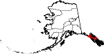
The census area has a land area of 7444 square miles (19,279.9 km²) and a water area of 3468 square miles (8,982.1 km²). A map showing its current boundaries is shown here:Adjacent boroughs and census areas
- Yakutat City and Borough, AlaskaYakutat City and Borough, AlaskaYakutat City and Borough is a unified city-borough in the U.S. state of Alaska. As of the 2010 census, the population was 4035. The name is Tlingit, Yaakwdáat, meaning "the place where canoes rest", but it originally derives from an Eyak name diyaʼqudaʼt and was influenced by the Tlingit word...
- northwest - Haines Borough, AlaskaHaines Borough, Alaska-Demographics:As of the census of 2000, there were 2,392 people, 991 households, and 654 families residing in the borough. The population density was 0,88 people per square mile . There were 1,419 housing units at an average density of 0,52 per square mile...
- northeast - Juneau City and Borough, Alaska - northeast
- Petersburg Census Area, Alaska - southeast
- Sitka City and Borough, AlaskaSitka City and Borough, AlaskaThe City and Borough of Sitka, originally called New Archangel under Russian Rule, is a unified city-borough located on Baranof Island and the southern half of Chichagof Island in the Alexander Archipelago of the Pacific Ocean , in the U.S...
- southwest
Also shares eastern border with British Columbia
British Columbia
British Columbia is the westernmost of Canada's provinces and is known for its natural beauty, as reflected in its Latin motto, Splendor sine occasu . Its name was chosen by Queen Victoria in 1858...
, Canada
Canada
Canada is a North American country consisting of ten provinces and three territories. Located in the northern part of the continent, it extends from the Atlantic Ocean in the east to the Pacific Ocean in the west, and northward into the Arctic Ocean...
.
- Stikine Region, British Columbia - northwest, east
- Kitimat-Stikine Regional District, British Columbia - southeast
National protected areas
- Glacier Bay National Park (part)
- Glacier Bay WildernessGlacier Bay WildernessGlacier Bay Wilderness is a wilderness area in Glacier Bay National Park and Preserve in the U.S. state of Alaska. It consists of the park section of 3.28-million-acre Glacier Bay National Park and Preserve...
(part)
- Glacier Bay Wilderness
- Tongass National ForestTongass National ForestThe Tongass National Forest in southeastern Alaska is the largest national forest in the United States at 17 million acres . Most of its area is part of the temperate rain forest WWF ecoregion, itself part of the larger Pacific temperate rain forest WWF ecoregion, and is remote enough to be home...
(part)- Admiralty Island National MonumentAdmiralty Island National MonumentAdmiralty Island National Monument is located on Admiralty Island in Southeast Alaska. It was created December 1, 1978, and covers 955,747 acres of Tongass National Forest in the Panhandle of southeast Alaska...
(part)- Kootznoowoo WildernessKootznoowoo WildernessThe temperate rainforests of Admiralty Island's Kootznoowoo Wilderness are unique among the of federally protected Wilderness in Southeast Alaska....
(part)
- Kootznoowoo Wilderness
- Chuck River WildernessChuck River WildernessChuck River Wilderness is a wilderness area located within the Tongass National Forest in the U.S. state of Alaska. It was designated by the United States Congress in 1990....
- Pleasant/Lemesurier/Inian Islands Wilderness
- Tracy Arm-Fords Terror Wilderness (part)
- West Chichagof-Yakobi WildernessWest Chichagof-Yakobi WildernessWest Chichagof-Yakobi Wilderness is a federally designated wilderness. It encompasses in Southeastern Alaska, in the United States. It includes Yakobi Island, the entire western side of Chichagof Island, as well as the many small island systems along their coasts.The wilderness was created...
(part)
- Admiralty Island National Monument
Demographics
- NOTE: Demographic data below is for the former "Skagway-Hoonah-Angoon" Census Area, which still includes Skagway Borough.
As of the census
Census
A census is the procedure of systematically acquiring and recording information about the members of a given population. It is a regularly occurring and official count of a particular population. The term is used mostly in connection with national population and housing censuses; other common...
of 2000, there were 3,436 people, 1,369 households, and 866 families residing in the census area. The population density
Population density
Population density is a measurement of population per unit area or unit volume. It is frequently applied to living organisms, and particularly to humans...
was 0.30 people per square mile (0.12/km²). There are 2,108 housing units. The racial makeup of the census area was 58.15% White
Race (United States Census)
Race and ethnicity in the United States Census, as defined by the Federal Office of Management and Budget and the United States Census Bureau, are self-identification data items in which residents choose the race or races with which they most closely identify, and indicate whether or not they are...
, 0.15% Black
Race (United States Census)
Race and ethnicity in the United States Census, as defined by the Federal Office of Management and Budget and the United States Census Bureau, are self-identification data items in which residents choose the race or races with which they most closely identify, and indicate whether or not they are...
or African American
Race (United States Census)
Race and ethnicity in the United States Census, as defined by the Federal Office of Management and Budget and the United States Census Bureau, are self-identification data items in which residents choose the race or races with which they most closely identify, and indicate whether or not they are...
, 35.01% Native American
Race (United States Census)
Race and ethnicity in the United States Census, as defined by the Federal Office of Management and Budget and the United States Census Bureau, are self-identification data items in which residents choose the race or races with which they most closely identify, and indicate whether or not they are...
, 0.38% Asian
Race (United States Census)
Race and ethnicity in the United States Census, as defined by the Federal Office of Management and Budget and the United States Census Bureau, are self-identification data items in which residents choose the race or races with which they most closely identify, and indicate whether or not they are...
, 0.15% Pacific Islander
Race (United States Census)
Race and ethnicity in the United States Census, as defined by the Federal Office of Management and Budget and the United States Census Bureau, are self-identification data items in which residents choose the race or races with which they most closely identify, and indicate whether or not they are...
, 0.96% from other races
Race (United States Census)
Race and ethnicity in the United States Census, as defined by the Federal Office of Management and Budget and the United States Census Bureau, are self-identification data items in which residents choose the race or races with which they most closely identify, and indicate whether or not they are...
, and 5.21% from two or more races. 2.82% of the population were Hispanic
Race (United States Census)
Race and ethnicity in the United States Census, as defined by the Federal Office of Management and Budget and the United States Census Bureau, are self-identification data items in which residents choose the race or races with which they most closely identify, and indicate whether or not they are...
or Latino
Race (United States Census)
Race and ethnicity in the United States Census, as defined by the Federal Office of Management and Budget and the United States Census Bureau, are self-identification data items in which residents choose the race or races with which they most closely identify, and indicate whether or not they are...
of any race. 3.95% reported speaking Tlingit
Tlingit language
The Tlingit language ) is spoken by the Tlingit people of Southeast Alaska and Western Canada. It is a branch of the Na-Dené language family. Tlingit is very endangered, with fewer than 140 native speakers still living, all of whom are bilingual or near-bilingual in English...
at home, while 1.83% speak Spanish
Spanish language
Spanish , also known as Castilian , is a Romance language in the Ibero-Romance group that evolved from several languages and dialects in central-northern Iberia around the 9th century and gradually spread with the expansion of the Kingdom of Castile into central and southern Iberia during the...
http://www.mla.org/map_data_results&state_id=2&county_id=232&mode=geographic&zip=&place_id=&cty_id=&ll=&a=&ea=&order=r.
There were 1,369 households out of which 30.80% had children under the age of 18 living with them, 49.30% were married couples
Marriage
Marriage is a social union or legal contract between people that creates kinship. It is an institution in which interpersonal relationships, usually intimate and sexual, are acknowledged in a variety of ways, depending on the culture or subculture in which it is found...
living together, 8.40% had a female householder with no husband present, and 36.70% were non-families. 30.10% of all households were made up of individuals and 5.60% had someone living alone who was 65 years of age or older. The average household size was 2.50 and the average family size was 3.14.
In the census area the population was spread out with 26.80% under the age of 18, 7.10% from 18 to 24, 29.50% from 25 to 44, 29.30% from 45 to 64, and 7.30% who were 65 years of age or older. The median age was 38 years. For every 100 females there were 116.40 males. For every 100 females age 18 and over, there were 120.70 males.
Cities and towns
- AngoonAngoon, AlaskaAngoon is a city on Admiralty Island in Hoonah-Angoon Census Area, Alaska, United States. At the 2000 census the population was 572, by the 2010 census the population had declined to 459...
- Cube CoveCube Cove, AlaskaCube Cove is a census-designated place on the northwestern side of Admiralty Island in Hoonah-Angoon Census Area, Alaska, United States. The population was 72 at the 2000 census.-Geography:Cube Cove is located at ....
- Elfin CoveElfin Cove, AlaskaElfin Cove is a census-designated place near the northwestern corner of Chichagof Island in Hoonah-Angoon Census Area, Alaska, United States...
- Game CreekGame Creek, AlaskaGame Creek is a census-designated place on Chichagof Island in Hoonah-Angoon Census Area, Alaska, United States. The population was 35 at the 2000 census.-Geography:Game Creek is located at...
- GustavusGustavus, AlaskaGustavus is a city in Hoonah-Angoon Census Area in the U.S. state of Alaska. At the 2000 census the population was 429.-Geography:Gustavus is located at ....
- Hobart BayHobart Bay, AlaskaHobart Bay is a census-designated place located in Hoonah-Angoon Census Area, Alaska. As of the 2010 Census, the population of the CDP was one....
- HoonahHoonah, AlaskaHoonah is a Tlingit community on Chichagof Island, located in Alaska's "panhandle" in the southeast region of the state. It is 30 miles west of Juneau, across the Alaskan Inland Passage. Hoonah is the only first-class city on Chichagof Island, the 109th largest island in the world and the 5th...
- KlukwanKlukwan, AlaskaKlukwan is a census-designated place in Hoonah-Angoon Census Area, Alaska, United States. At the 2000 census the population was 139.-History:...
- PelicanPelican, AlaskaPelican is a city in the northwestern part of Chichagof Island in Hoonah-Angoon Census Area in the U.S. state of Alaska. As of the 2000 census, the population of the city is 163.-Geography:...
- Tenakee SpringsTenakee Springs, AlaskaTenakee Springs is a city on Chichagof Island in Hoonah-Angoon Census Area, Alaska, United States. At the 2000 census the population was 104.-Geography:Tenakee Springs is located at ....
- Whitestone Logging CampWhitestone Logging Camp, AlaskaWhitestone Logging Camp is a census-designated place on Chichagof Island in Hoonah-Angoon Census Area, Alaska, United States. At the 2000 census the population was 116.-Geography:...
See also
- List of airports in the Hoonah-Angoon Census Area