

Skagit Bay
Encyclopedia
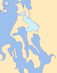
Bay
A bay is an area of water mostly surrounded by land. Bays generally have calmer waters than the surrounding sea, due to the surrounding land blocking some waves and often reducing winds. Bays also exist as an inlet in a lake or pond. A large bay may be called a gulf, a sea, a sound, or a bight...
and strait
Strait
A strait or straits is a narrow, typically navigable channel of water that connects two larger, navigable bodies of water. It most commonly refers to a channel of water that lies between two land masses, but it may also refer to a navigable channel through a body of water that is otherwise not...
located in the U.S. state
U.S. state
A U.S. state is any one of the 50 federated states of the United States of America that share sovereignty with the federal government. Because of this shared sovereignty, an American is a citizen both of the federal entity and of his or her state of domicile. Four states use the official title of...
of Washington. It is part of the Whidbey Island Basin of Puget Sound
Puget Sound
Puget Sound is a sound in the U.S. state of Washington. It is a complex estuarine system of interconnected marine waterways and basins, with one major and one minor connection to the Strait of Juan de Fuca and the Pacific Ocean — Admiralty Inlet being the major connection and...
. The Skagit River
Skagit River
The Skagit River is a river in southwestern British Columbia in Canada and northwestern Washington in the United States, approximately 150 mi long...
empties into Skagit Bay. To the south, Skagit Bay connects with the rest of Puget Sound via Saratoga Passage
Saratoga Passage
Saratoga Passage lies in Puget Sound between Whidbey Island and Camano Island.Saratoga Passage extends about 18 miles in a northwesterly direction from its entrance between Sandy Point on the Whidbey Island side and Camano Head on the other. At its northern end, Saratoga Passage connects with Penn...
and Possession Sound
Possession Sound
Possession Sound is part of Puget Sound, located in the U.S. state of Washington between Whidbey Island and the coastline of Snohomish County approximately between the cities of Everett and Mukilteo. Possession Sound connects the main Puget Sound basin to the south with Saratoga Passage and Port...
. The boundary between Saratoga Passage and Skagit Bay is between Ponell Point on Whidbey Island
Whidbey Island
Whidbey Island is one of nine islands located in Island County, Washington, in the United States. Whidbey is located about north of Seattle, and lies between the Olympic Peninsula and the I-5 corridor of western Washington...
and Rocky Point on Camano Island
Camano Island
Camano Island is a large island in the Possession Sound portion of Puget Sound, located in Island County, Washington, between Whidbey Island and the mainland. The body of water separating Whidbey Island and Camano Island is called Saratoga Passage. Camano Island is separated from mainland...
. To the northwest, Skagit Bay connects to the Strait of Juan de Fuca
Strait of Juan de Fuca
The Strait of Juan de Fuca is a large body of water about long that is the Salish Sea outlet to the Pacific Ocean...
via the narrow strait of Deception Pass
Deception Pass
Deception Pass is a strait separating Whidbey Island from Fidalgo Island, in the northwest part of the U.S. state of Washington. It connects Skagit Bay, part of Puget Sound, with the Strait of Juan de Fuca.-History:...
. A third waterway, the Swinomish Channel, connects Skagit Bay with Padilla Bay
Padilla Bay
Padilla Bay is bay located in the U.S. state of Washington, between the San Juan Islands and the mainland. Fidalgo Island and Guemes Island lie to the west of Padilla Bay. Guemes Channel, between the islands, connects Padilla Bay to Rosario Strait...
to the north.
Skagit Bay is bounded by the Whidbey Island to the west, Fidalgo Island
Fidalgo Island
Fidalgo Island is an island in Skagit County, Washington, located about north of Seattle. To the east, it is separated from the mainland by the Swinomish Channel, and from Whidbey Island to the south by Deception Pass...
to the north, Camano Island to the south, and the mainland to the east. The mainland coast consists almost entirely of the Skagit River delta, including Fir Island
Fir Island (Washington)
Fir Island is bounded by North and South Forks of the Skagit River and Skagit Bay of Puget Sound in the southwestern corner of Skagit County, Washington. Triangular in outline, east–west by north–south with an area of nearly , Fir Island is occupied by 195 families...
, between the North Fork and South Fork distributaries
Distributary
A distributary, or a distributary channel, is a stream that branches off and flows away from a main stream channel. They are a common feature of river deltas. The phenomenon is known as river bifurcation. The opposite of a distributary is a tributary...
of the Skagit River.
The northern end of Skagit Bay is called Similk Bay. Two islands at the northern end are marine state parks, Hope Island and Skagit Island. The Swinomish Indian Reservation is also located at the north end of Skagit Bay, between Similk Bay and the Swinomish Channel on Fidalgo Island.
History
Members of the 1792 Vancouver ExpeditionVancouver Expedition
The Vancouver Expedition was a four-and-a-half-year voyage of exploration and diplomacy, commanded by Captain George Vancouver. The expedition circumnavigated the globe, touched five continents and changed the course of history for the indigenous nations and several European empires and their...
were the first non-indigenous people to find and explore Skagit Bay. On May 30, 1792, Joseph Whidbey
Joseph Whidbey
Joseph Whidbey was a member of the Royal Navy who served on the Vancouver Expedition 1791–1795, and later achieved renown as a naval engineer. He is notable for having been the first European to discover and chart Admiralty Island in the Alexander Archipelago in 1794.Little is recorded of...
led a boat survey team up Saratoga Passage
Saratoga Passage
Saratoga Passage lies in Puget Sound between Whidbey Island and Camano Island.Saratoga Passage extends about 18 miles in a northwesterly direction from its entrance between Sandy Point on the Whidbey Island side and Camano Head on the other. At its northern end, Saratoga Passage connects with Penn...
and into Skagit Bay. They spent a day surveying but did not see Deception Pass
Deception Pass
Deception Pass is a strait separating Whidbey Island from Fidalgo Island, in the northwest part of the U.S. state of Washington. It connects Skagit Bay, part of Puget Sound, with the Strait of Juan de Fuca.-History:...
and so thought Skagit Bay was closed. The next day George Vancouver
George Vancouver
Captain George Vancouver RN was an English officer of the British Royal Navy, best known for his 1791-95 expedition, which explored and charted North America's northwestern Pacific Coast regions, including the coasts of contemporary Alaska, British Columbia, Washington and Oregon...
noted the swampy waterway connecting Port Susan
Port Susan
Port Susan is a bay and strait located in the U.S. state of Washington. Part of the Whidbey Island Basin of Puget Sound, Port Susan is bounded by Camano Island to the west and the mainland to the east. The Stillaguamish River empties into the northern end of Port Susan. To the south, Port Susan...
to Skagit Bay at the north end of Camano Island. Later, on June 7, Vancouver's ships passed by Deception Pass from the west. Peter Puget
Peter Puget
Peter Puget was an officer in the Royal Navy, best known for his exploration of Puget Sound.-Mr. Midshipman Puget:Puget's ancestors had fled France for Britain during Louis XIV's persecution of the Huguenots. His father, John, was a successful merchant and banker, but died in 1767, leaving Puget's...
and Joseph Whidbey took boats to investigate the opening and found it connected to Skagit Bay, making Whidbey Island an island instead of a peninsula.