
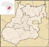
Simolândia
Encyclopedia
| Simolândia | |
|---|---|
| State | Goiás Goiás Goiás is a state of Brazil, located in the central part of the country. The name Goiás comes from the name of an indigenous community... |
| Geographical Coordinates: | 14°28′38"S 46°28′56"W |
| Area: | 347.8 km² |
| Population: | 6,915 (IBGE 2007) |
| Elevation: | 500m above sea level |
| Postcode (CEP): | 73930-000 |
| IBGE statistical microregion: | 018 Vão do Paranã |
| Became a city: | 1989 |
| Mayor: | Celso Zanon |
| Distance to Goiânia Goiânia -Climate:The city has a tropical wet and dry climate with an average temperature of . There's a wet season, from October to April, and a dry one, from May to September. Annual rainfall is around 1,520 mm.... : |
460 km. |
| Website: | none |
Town
A town is a human settlement larger than a village but smaller than a city. The size a settlement must be in order to be called a "town" varies considerably in different parts of the world, so that, for example, many American "small towns" seem to British people to be no more than villages, while...
and municipality
Municipality
A municipality is essentially an urban administrative division having corporate status and usually powers of self-government. It can also be used to mean the governing body of a municipality. A municipality is a general-purpose administrative subdivision, as opposed to a special-purpose district...
in northeast Goiás
Goiás
Goiás is a state of Brazil, located in the central part of the country. The name Goiás comes from the name of an indigenous community...
state, Brazil
Brazil
Brazil , officially the Federative Republic of Brazil , is the largest country in South America. It is the world's fifth largest country, both by geographical area and by population with over 192 million people...
.
Location and Geography
Simolândia is situated in the northeast of Goiás, at kilometer 250 of the important BR-020 (Belém-Brasília highway). It forms boundaries with PossePosse, Goiás
Posse is a small town and municipality in northeastern Goiás state, Brazil.-Geography:It is located northeast of Brasília, 24 km. from the state boundary with Bahia, on interstate highway BR-020...
, Alvorada do Norte
Alvorada do Norte
Alvorada do Norte is a small town and municipality in northeastern Goiás state, Brazil. It is an important commercial center on the Brasília-Salvador highway.-Location:...
and Buritinópolis
Buritinópolis
Buritinópolis is a small town and municipality in eastern Goiás state, Brazil. It is the poorest municipality in the state.-Location:Buritinópolis is located in the Vão do Paranã statistical micro-region in the area near Simolândia and Alvorada do Norte. It is close to the important BR-020...
. It belongs to the Vão do Paranã statistical micro-region]].
The distance to Goiânia
Goiânia
-Climate:The city has a tropical wet and dry climate with an average temperature of . There's a wet season, from October to April, and a dry one, from May to September. Annual rainfall is around 1,520 mm....
is 460 km. Highway connections are made by BR-153 / Anápolis
Anápolis
Anápolis is the third largest city in the State of Goiás in Brazil. It lies in the center of a rich agricultural region and has become a leader in food processing and pharmaceutical plants.-Location and population:...
/ BR-060 / Alexânia
Alexânia
Alexânia is a small town and municipality in central Goiás state, Brazil. Alexânia is known for its alleged extraterrestrial sightings in the late sixties and early seventies. The Areias River passes through the municipality.-Location:...
/ Sobradinho
Sobradinho
The Sobradinho Reservoir is a large reservoir located in Sobradinho, north of the Brazilian state of Bahia. The reservoir measures approximately long, in surface area, and a storage capacity of at its nominal elevation of , making it the 12th-largest reservoir in the world...
/ Planaltina
Planaltina
Planaltina is one of the administrative districts of the Federal District of Brazil, with an area of 1,534 kmª and a population of 147,114 in 2000, of whom 134,663 were classified as urban and 12,451 as rural...
/ Formosa
Formosa, Goiás
Formosa is a city and municipality located in the state of Goiás, Brazil, approximately 80 kilometers east of Brasília. The population was 90,247 in a total area of 5,806.89 km² . Formosa is known for its waterfalls and natural beauty...
/ BR-020 / BR-030 / BR-020 / Vila Boa
Vila Boa, Goiás
Vila Boa is a small town and municipality in northeastern Goiás state, Brazil.-Location:Vila Boa is located on the extreme northeast limit of the Entorno de Brasília microregion. The nearest major population center is Formosa, which is 95 km. to the southeast...
/ Alvorada do Norte
Alvorada do Norte
Alvorada do Norte is a small town and municipality in northeastern Goiás state, Brazil. It is an important commercial center on the Brasília-Salvador highway.-Location:...
.
The municipality lies mainly on the slopes of the Serra da Chapadinha and the topography is broken by several rivers: the Corrente, Salobro and Buriti, which are popular with tourists. The climate is hot and dry. The vegetation is made up of 60% forest and 40% savanna. Hardwoods are exported or used in the furniture industry.
Demographic Information
- Population density: 19.88 inhab/km² (2007)
- Urban population: 5,735 (2007)
- Rural population: 1,189 (2000)
- Population growth: a gain of about 1,000 people since 1991
Economic Information
The economy is based on subsistence agriculture, cattle raising (19,100 head in 2006), services, public administration, and small transformation industries. There were no banks in 2007. There were 362 automobiles in 2007.- Motor vehicles: 443 (automobiles and pickup trucks)
- Number of inhabitants per motor vehicle: 15
Agricultural data 2006
- Farms: 345
- Total area: 23,174 ha.
- Area of permanent crops: 255 ha.
- Area of perennial crops: 723 ha.
- Area of natural pasture: 14,657 ha.
- Area of woodland and forests: 7,432 ha.
- Persons dependent on farming: 950
- Tractors: 33
- Cattle herd: 19,100
- Main crops: 540 hectares
Health and education
- Schools: 15
- Classrooms: 49
- Teachers: 110
- Students: 2,596 (2006)
- Hospitals: 1 with 16 beds (2007)
- Higher education: none
- Adult literacy rate: 76.1% (2000) (national average was 86.4%)
- Infant mortality rate: 33.48 (2000) (national average was 33.0)
Simolândia was ranked 233 out of 242 municipalities in the state of Goiás on the United Nations Human Development Index
Human Development Index
The Human Development Index is a composite statistic used to rank countries by level of "human development" and separate "very high human development", "high human development", "medium human development", and "low human development" countries...
with a score of 0.657. Nationally it was ranked 3,649 out of 5,507 municipalities in 2000. (All data are from 2000.)
See also
- List of municipalities in Goiás
- Microregions in GoiásMicroregions in GoiásThe state of Goiás is divided into 18 statistical microregions by the Instituto Brasileiro de Geografia e Estatístic . These have no administrative function but are used only for statistics...